Characteristics of modern flood deposits in the Drainage basin of Mi River, Shandong Province and the reconstruction of hydrodynamic processes
-
摘要: 随着全球气候变化加剧,强天气过程以及由此引发的洪水危害愈来愈严重。理解现代洪水沉积特征,不仅可以为减轻洪水灾害提供理论指导,而且也为识别古洪水沉积提供参照依据。2018年8月中旬,山东弥河流域受双台风影响发生洪涝灾害,对当地社会发展、人民生活造成严重影响。在对洪水淹没区考察基础上,于下游高河漫滩区、洪水沉积物保存完好的地点获取21.5 cm长岩芯MH1(含现代土壤),并进行了粒度、孢粉、磁化率、烧失量分析。结果显示:钻孔岩芯洪水层沉积物以黏土和细粉砂为主,平均砂含量仅为1.7%,反映洪水强度不大;洪水沉积层粒度可识别出7.9和30.0 μm两个敏感组分,根据其含量变化特征,可将此次洪水过程划分为洪水初期、第一次洪峰、高水位期、第二次洪峰、退水期5个阶段;洪水沉积层烧失量显著高于土壤层,而磁化率值整体低于下伏土壤层;洪水层与土壤层孢粉特征无明显差异,表明两者孢粉组合均能反映小流域植被状况,但洪水堆积层孢粉丰度(7313.96粒/g)远高于下伏土壤层(1562.65粒/g)。实验结果揭示洪水沉积环境有利于孢粉富集,磁化率值可能反映土壤发育过程中磁性矿物的产生与积累(成壤强度),因此可作为识别古洪水层与古土壤层的参考指标,但其地理空间适用性有待进一步探讨。Abstract: With the aggravation of global climate change, severe weather processes and resulted flood disasters become more and more serious nowadays. Understanding the characteristics of modern flood deposition, not only provide theoretical guidance for flood mitigation, but also offer evidence and referential benchmarks for the identification of paleoflood deposits and reconstruction of paleoenvironment. In the mid-August of 2018, two typhoons hit the drainage basin of the Mihe River in the northern Shandong Province and caused serious damage and economic loss. Based on the surveys of the flooded areas, a 21.5-cm-long sediments core labeled MH1, including modern soil, was drilled in the high floodplain of downstream area where flood deposits are well preserved, and the grain size, pollen, magnetic susceptibility, and loss-on -ignition are analyzed. The results suggest that flood layer deposits are mainly composed of clay and fine silt, and the average content of sand is only 1.7%, indicating that the flood intensity was quite low. Two environmentally sensitive grain size components, 7.9 μm and 30 μm respectively, are identified in the flood sediment layer. According to the variation characteristics of sediments, the flood process can be divided into five stages: initial flooding, first flood peak, high-water level period, second flood peak, and flood recession period. The loss-on-ignition of flood sediment layer is also significantly higher than that of soil layer, with a lower magnetic susceptibility value. There is no significant difference in pollen characteristics between the flood layer and soil layer, suggesting that the pollen assemblages of flood plain soil and flood sediment can both be used to define the vegetation of the watershed. However, the pollen abundance of flood accumulation layer (7313.96 grains/g) is much higher than that of underlying soil layer (1562.65 grains/g). The experimental results suggest that the flood has the function to enrich the sporopollen to certain extent, and the magnetic susceptibility value may reflect the generation and accumulation of magnetic minerals in the process of soil formation. Therefore, they can be used as a reference index to identify palaeoflood and palaeosoil layers. However, the geospatial scope of their use needs to be further investigated.
-
Keywords:
- modern flood deposition /
- hydrodynamic process /
- grain size /
- pollen /
- magnetic susceptibility /
- Mihe River
-
近几十年来,在考古地层与现代河漫滩沉积中均发现有洪水事件沉积[1-3],进一步研究揭示,古洪水可能极大地影响了流域内文明演进,甚至带来毁灭性打击[4-5]。洪水沉积层作为古洪水事件的地质信息载体,其准确识别是进行古气候与古水文研究的必要前提[6-7]。目前学术界对现代洪水沉积特征研究集中于河流中上游地区的巨能洪水沉积与滞流沉积[8-9],滞流沉积是洪水期河流两岸达到最高水位且流速接近零的状态下,逐渐在岸边沉积下来的“上细下粗”沉积单元层[10],是识别古洪水事件的常用载体,其沉积学特征和识别标志主要有:呈现明显斜层理或交错层理、水平或波状层理,末端翘起的构造特征;粒度负偏分布的结构特征;重矿物组合单调且含量偏低的矿物特征[11];磁化率和有机质含量较低的地球物理化学特征[12];以及古生物学标志等[13-15]。然而,滞流沉积物仅在河流中上游的峡谷地区较易赋存,河流下游泛滥平原地区的洪水沉积特征研究相对较少[16],尤其缺乏系统研究一次洪水沉积过程及其与下伏地层的对比。由此导致古洪水层识别缺乏参考系,仍多依赖经验法,从而可能造成判识偏差,甚至产生一定争议[17-18]。因此,遵循“将今论古”的研究思路,充分认识现代洪水沉积特征是识别地层中古洪水事件的重要前提和依据[19-20]。弥河位于山东省北部,下游属泛滥平原地区,是全国重要的蔬菜种植区,区域内古文化遗址众多,历史时期洪水灾害频发,严重影响和威胁该地区人民生命财产安全和社会经济可持续发展[21]。本文选取弥河下游2018年洪水事件为研究案例,获取新鲜洪水沉积物及下伏土壤层岩芯,进行孢粉、粒度、烧失量和磁化率等指标分析,充分认识现代洪水沉积特征,探讨其变化规律及影响因素,对比洪水层与土壤层沉积差异并建立洪水沉积判定标志,为识别全新世泛滥平原地区古洪水层提供可靠依据。
1. 研究区概况
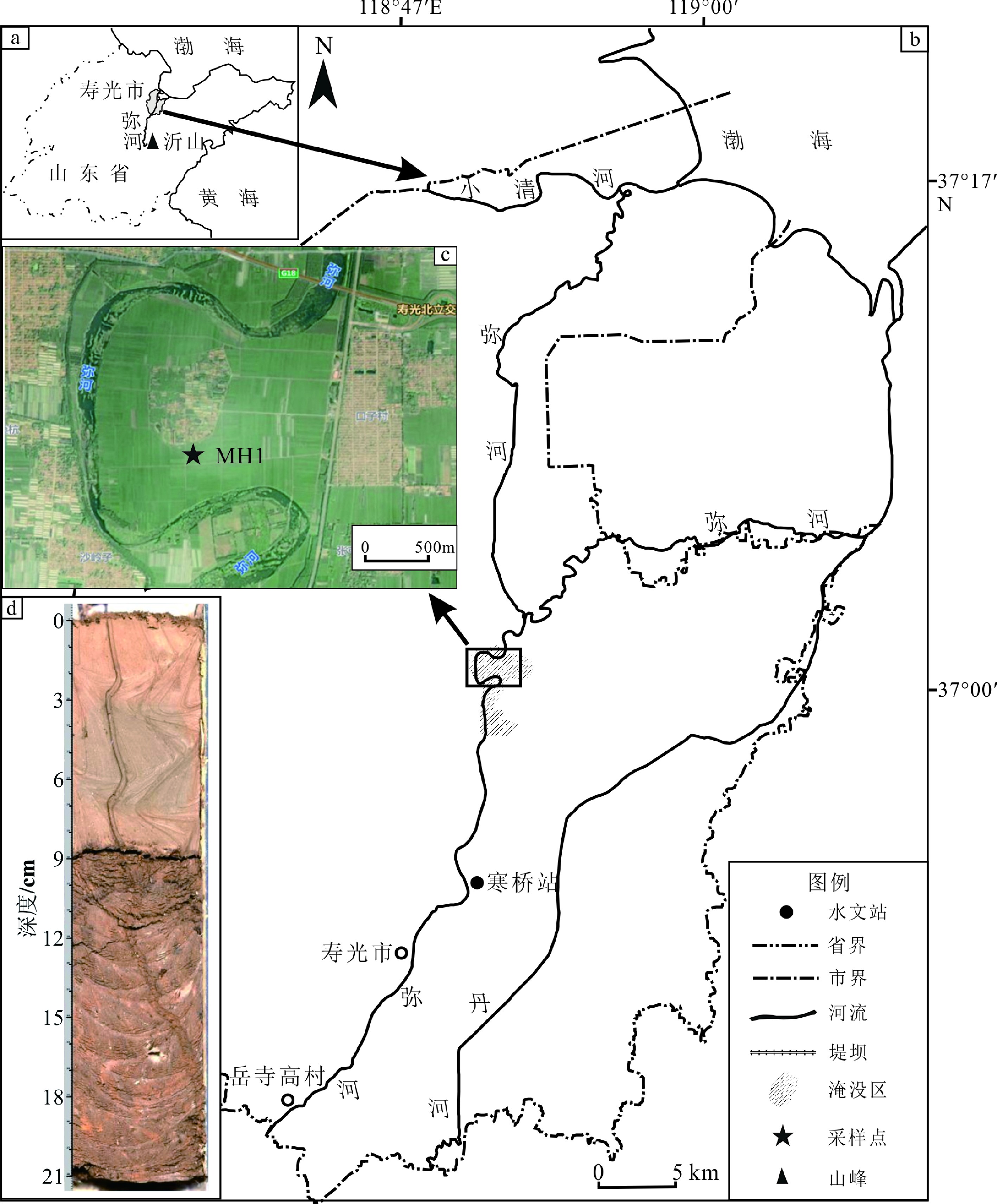
弥河发源于山东中部沂山,全长206 km,总体为北偏东流向,注入渤海莱州湾(图1a),流域面积3847.5 km2,多年平均径流深度156.5 mm。岳寺高村以下为下游,河长96 km,流经山前平原和滨海低地区,河道平均比降为0.4‰(图1b)。流域年均降水量约为600 mm,降水分配不均,集中在5—8月,多发旱涝灾害,有水文记录以来(截至2017年),最大洪峰流量发生在1963年7月19日,达到2870 m3/s。近40年来断流天数呈逐渐增加趋势,特别是1981年以来,寒桥站监测年断流天数均在150天以上。河流上游地区林地面积相对较大,下游以旱作粮食作物和蔬菜种植为主[22]。2018年8月中旬,台风“摩羯”和“温比亚”接连影响弥河流域,带来强降水,河流水位迅速升高,中游洪峰流量接近2500 m3/s,下游发生多处漫堤和决堤险情,形成洪涝灾害。
![]() 图 1 弥河下游流域及钻孔位置a. 弥河流域位置图,b. 弥河下游流域图,c. 采样点位置遥感图,d. MH1钻孔岩芯图。Figure 1. Location of the downstream of Mi river and the drilling pointa. Location of Mi River basin, b. The lower reaches of Mi River, c. Location of sampling site, d. The lithology of MH1 core.
图 1 弥河下游流域及钻孔位置a. 弥河流域位置图,b. 弥河下游流域图,c. 采样点位置遥感图,d. MH1钻孔岩芯图。Figure 1. Location of the downstream of Mi river and the drilling pointa. Location of Mi River basin, b. The lower reaches of Mi River, c. Location of sampling site, d. The lithology of MH1 core.2. 材料与方法
2.1 样品采集
2018年10月,笔者考察了弥河流域洪水淹没区,并在下游高河漫滩区选择新鲜洪水沉积物保存较为原始的地点(图1b—c),提取21.5 cm长沉积物岩芯MH1,其中0~9 cm为黄色洪水沉积,以黏土和粉砂为主,未见明显层理,下段为棕色现代土壤层(图1d)。钻孔位于弥河下游宽谷地区,地势平坦,河床宽100~200 m,行洪河道宽约2 km,河漫滩高出河床约2.5 m(图1c),堤坝高出河漫滩约3 m。2018年洪水水位接近坝顶,并于部分河段发生漫堤和决堤,淹没堤坝外侧部分地区(图1b)。该区域以小麦、玉米等旱作农业为主,河滩区域为杂草荒地。
浅钻带回实验室后剖开,以0.5 cm间隔分样,获得43个样品,全部进行粒度、碳酸盐及有机质含量、磁化率分析(少数层位样品量不足时将相邻样品合并测试),并选取洪水和土壤层各两个样品(深度分别为2~2.5、6~6.5、10~10.5、15~15.5 cm)进行孢粉分析。
2.2 实验方法
样品粒度测试所用仪器为Mastersizer 2000型激光粒度仪,首先加浓度为30%的H2O2以除去样品中有机质,然后加10 mL浓度为0.05 mol/L的(NaPO3)6作为分散剂,并用超声波震荡10 min后测量[23]。测试结果采用粒级-标准偏差法进行分析[24],通过计算每一粒级所对应含量的标准偏差获得粒度敏感组分的个数和分布范围,计算公式为:
$$S=\sqrt {\frac{1}{N-1}\sum_{i=1}^N (x_i-\bar x)^2}$$ (1) 式中,S为变量x的标准偏差(本文x为各粒级含量),xi为样本值,N为样本数。
有机质和碳酸盐含量采用烧失法测定[25-26]:将恒重坩埚清洗干净,放入105 ℃恒温鼓风烘箱加热8 h,取出放入干燥器至室温后称重;取充分干燥的粉末状样品至称量好的坩埚中,放入105 ℃恒温鼓风烘箱加热6~8 h,取出放入干燥器冷却至室温后称重;将称重后的坩埚及样品放入设定温度为550 ℃的马弗炉内加热2 h,放入干燥器中冷却至室温后称重;再将称重过后的坩埚放入950 ℃马弗炉里烧1 h,关掉马弗炉冷却至250 ℃,用镊子取出放入干燥器至室温后称重。根据称量结果,进行数学换算得到有机质含量和碳酸盐含量。
磁化率采用英国Bartington仪器公司生产的MS2型磁化率仪,在远离干扰磁场的情况下,对样品进行低频磁化率(470 Hz)和高频磁化率(4700 Hz)测试。每个样品分别测试3次后取平均值,得到低频质量磁化率(χlf)和高频质量磁化率(χhf),并由此计算出频率磁化率(χfd)和频率磁化率百分比(χfd%),其中,频率磁化率χfd=χlf−χhf,频率磁化率百分比χfd%=(χlf−χhf)/χlf×100%[27]。以上实验在云南师范大学高原湖泊生态与全球变化重点实验室完成。
孢粉提取采用HF法,鉴定和统计在Nikon光学显微镜10×100倍下进行,每个样品不少于300粒花粉,孢粉百分比含量按孢子和花粉总数计算[28],该实验在中国科学院南海海洋研究所边缘海与大洋地质重点实验室完成。
3. 结果
3.1 粒度组分与参数特征
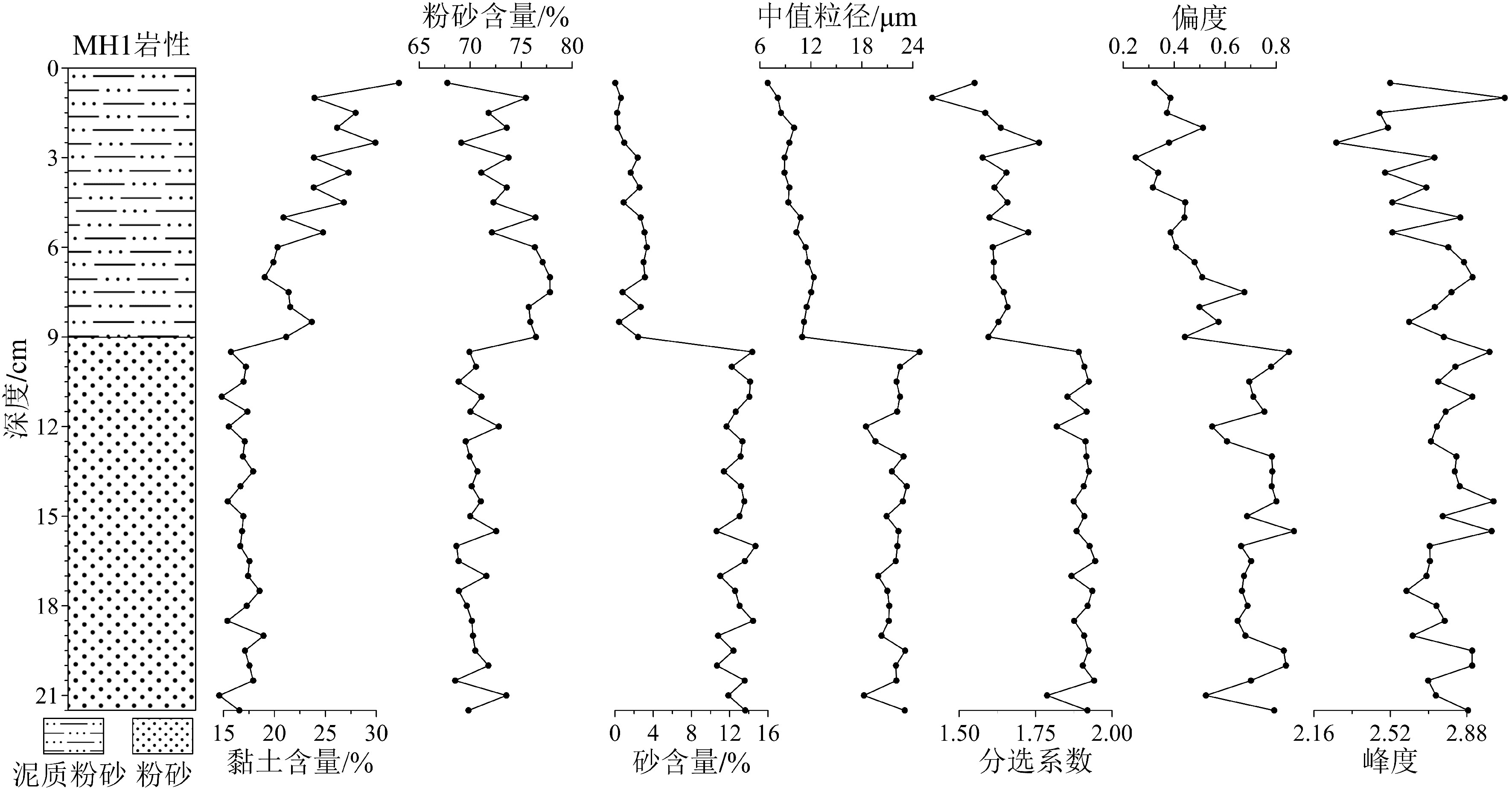
粒度测试结果显示(表1,图2),MH1孔以粉砂为主,含量变化范围为67.76%~77.83%,平均含量达到71.95%;黏土平均含量19.90%,大致呈逐渐增加趋势;砂含量变化范围为0.03%~14.69%,呈显著两段式特征:0~9 cm平均含量仅为1.73%,下段平均含量达到12.78%;中值粒径范围为5.82~24.81 μm,平均值6.34 μm,变化模式与砂含量相似。
表 1 MH1孔各指标参数数值Table 1. Values of index parameters of MH1 core深度/cm 中值粒径/μm 黏土含量/% 砂含量
/%有机质含量
/%碳酸盐含量
/%磁化率χlf
/(10−8 m3/kg)孢粉丰度
/(粒/g)0~0.5 6.93 32.21 0.03 7.24 6.35 8.03 0.5~1 8.12 23.92 0.62 6.77 6.45 1~1.5 8.48 27.97 0.23 6.47 6.54 8.32 1.5~2 10.02 26.14 0.27 6.13 6.22 7.76 2~2.5 9.45 29.91 0.95 5.78 5.68 8.46 6608.14 2.5~3 8.92 23.86 2.38 6.68 5.92 8.71 3~3.5 8.88 27.27 1.64 6.09 6.17 8.47 3.5~4 9.46 23.84 2.57 6.07 6.26 4~4.5 9.33 26.82 0.90 5.88 6.18 8.78 4.5~5 10.77 20.90 2.69 6.15 6.03 8.69 5~5.5 10.31 24.78 3.10 5.87 6.19 8.68 5.5~6 11.38 20.31 3.34 5.91 6.11 7.91 6~6.5 11.65 19.90 2.99 6.12 5.84 7.94 8019.79 6.5~7 12.34 19.05 3.13 6.01 5.99 7.21 7~7.5 12.03 21.38 0.79 5.92 6.62 7.32 7.5~8 11.51 21.56 2.69 5.97 6.73 7.05 8~8.5 11.20 23.67 0.42 5.96 6.78 6.52 8.5~9 10.96 21.15 2.41 6.18 7.73 9~9.5 24.81 15.73 14.35 6.40 7.55 6.48 9.5~10 22.49 17.21 12.21 4.94 3.17 10~10.5 22.07 16.98 14.15 4.34 3.17 9.25 1614.49 10.5~11 22.49 14.83 14.06 5.54 3.02 11~11.5 22.15 17.34 12.63 4.68 2.68 9.36 11.5~12 18.47 15.53 11.66 4.42 2.89 9.20 12~12.5 19.59 17.09 13.34 5.13 2.72 9.23 12.5~13 22.89 16.91 13.14 4.88 2.69 9.63 13~13.5 21.52 17.90 11.40 4.40 2.70 9.52 13.5~14 23.28 16.67 13.18 4.01 2.48 9.24 14~14.5 22.83 15.43 13.52 3.81 2.65 9.03 14.5~15 20.91 16.96 13.04 3.73 2.42 9.55 15~15.5 22.31 16.82 10.63 4.75 2.62 9.43 1510.82 15.5~16 22.18 16.65 14.69 4.95 2.42 9.62 16~16.5 21.99 17.55 13.58 4.03 2.31 9.50 16.5~17 19.92 17.41 11.01 4.10 2.50 9.83 17~17.5 21.00 18.55 12.57 4.17 2.31 9.25 17.5~18 21.23 17.29 13.04 3.87 2.51 9.17 18~18.5 21.17 15.40 14.43 3.70 2.63 9.34 18.5~19 20.31 18.93 10.80 3.85 2.63 9.44 19~19.5 23.10 17.11 12.39 3.77 2.65 9.28 19.5~20 22.01 17.54 10.67 4.34 2.64 9.36 20~20.5 22.05 17.91 13.57 4.23 2.26 9.59 20.5~21 18.24 14.59 11.86 3.87 2.66 9.50 21~21.5 23.04 16.55 13.63 3.74 2.80 9.04 ![]() 图 2 MH1钻孔粒度参数及组分随深度变化曲线Figure 2. Curves of grain size parameters and components with depth in MH1 core
图 2 MH1钻孔粒度参数及组分随深度变化曲线Figure 2. Curves of grain size parameters and components with depth in MH1 core粒度参数根据McManus 1988年提出的矩值法公式[29]计算(表1,图2),分选系数变化范围为1.41~1.95,平均值1.78,洪水沉积层分选性稍好于土壤层;峰度波动范围为2.27~3.06,属宽平或很宽平峰态,洪水沉积物相比土壤层略偏细;偏度变化范围为0.25~0.87,平均值为0.60,属近对称或正偏,无明显变化特征。
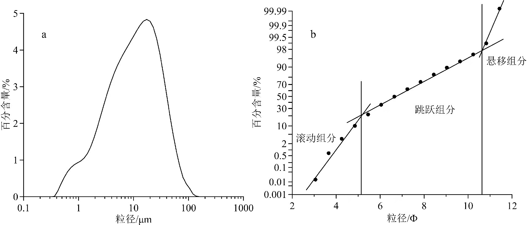
洪水淤积层粒度频率曲线呈单峰态(图3a),峰值出现在约20 μm,主峰较窄,略偏粗,同时在约1 μm处出现较明显细粒组分。概率累积曲线为典型三段式(图3b),截点分别出现在约5和10.7Φ处,粒度组成以跳跃搬运组分为主,含量接近80%,滚动组分约占20%,悬移组分含量不足5%。
![]() 图 3 MH1钻孔洪水沉积层平均粒度频率曲线(a)与概率累积曲线(b)Figure 3. Distribution frequency(a) and probability accumulation curves(b) of the flood deposits in the MH1 core
图 3 MH1钻孔洪水沉积层平均粒度频率曲线(a)与概率累积曲线(b)Figure 3. Distribution frequency(a) and probability accumulation curves(b) of the flood deposits in the MH1 core3.2 烧失量
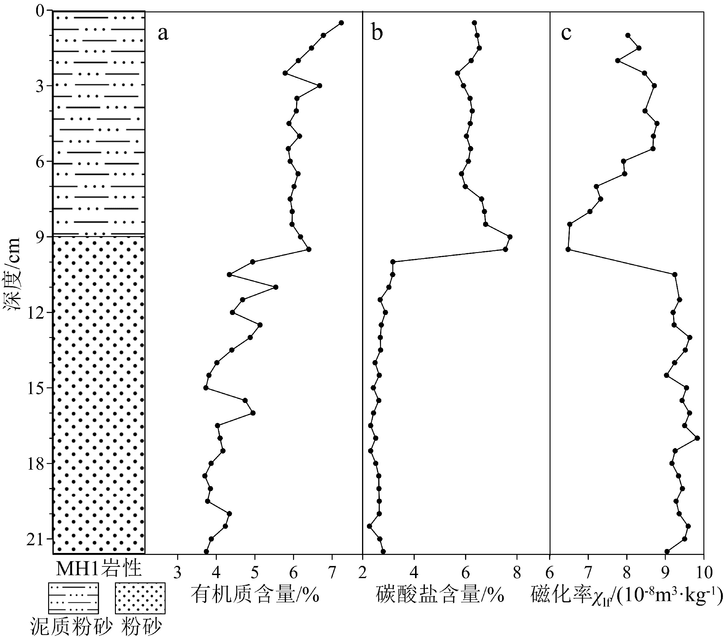
MH1孔有机质含量范围为3.70%~7.24%,呈波动增加趋势,洪水层含量明显高于下部土壤层(图4a);碳酸盐含量为2.26%~7.73%,平均值4.30%(表1),变化特征与有机质含量相似,但其两段式模式更为显著:下段土壤层碳酸盐含量非常稳定,波动范围为2.26%~3.17%,平均2.65%,上段洪水层平均值6.39%,且在沉积界面处呈突变式升高(图4b)。
![]() 图 4 MH1孔烧失量、磁化率变化曲线Figure 4. Curves of ignition loss and magnetic susceptibility of MH1 core
图 4 MH1孔烧失量、磁化率变化曲线Figure 4. Curves of ignition loss and magnetic susceptibility of MH1 core3.3 磁化率特征
钻孔低频质量磁化率χlf变化范围为6.48×10⁻⁸~9.82×10⁻⁸ m3/kg,平均值8.75×10−8 m3/kg,土壤层为磁化率高值区,且波动较小,平均为9.25×10−8 m3/kg(表1),沉积界面处磁化率值迅速降低,虽然随后又有所回升,但总体而言洪水层磁化率低于土壤层(图4c)。
3.4 孢粉组合变化
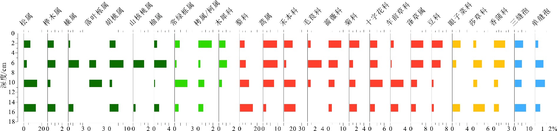
MH1孔所选4个样品共鉴定出孢粉35个科属。孢粉组合中以草本花粉为主,共19个属种,占总含量的68.40%,主要有禾本科(Gramineae)(21.22%)、藜科(Chenopodiaceae)(10.08%)、蒿属(Artemisia)(7.67%)、蔷薇科(Rosaceae)(5.51%)、葎草属(Humulus)(4.91%)、十字花科(Cruciferae)(3.57%)、豆科(Leguminosae)(3.37%)、莎草科(Cyperaceae)(3.07%)、车前草科(Plantaginaceae)(1.89%)、菊科(Compositae)(1.83%)、香蒲科(Typhaceae)(1.78%)和眼子菜科(Potamogetonaceae)(1.13%)等;其次是木本花粉,共16个科属,占总含量的24.50%,主要有胡桃属(Juglans)(5.59%)、松属(Pinus)(5.56%)、榆属(Ulmus)(4.03%)、桦木属(Betula)(1.94%)、落叶栎属(Deciduous Quercus)(1.68%)等;蕨类孢子含量最小,为7.11%,以三缝孢为主(图5)。
4. 讨论
4.1 细粒洪水沉积及其成因
粒度组成是洪水沉积物研究的基本手段之一,其结果有助于推断沉积物来源、搬运动力及沉积环境[6]。剖面宏观特征显示洪水层水平沉积层理不发育,粒级含量结果(图2)表明MH1孔粒度下粗上细,指示钻孔位置洪水动力较弱,粗粒组分输入少。从粒度自然分布频率曲线与概率累积曲线特征也可以看出(图3),洪水沉积物以跳跃搬运组分为主,分选性较好,揭示洪水具有一定流动性,但流速不快。
MH1孔粒度沉积特征除受洪水水动力影响外,还与取样点土壤粒度粗细相关,不同地点和洪水条件下可能具有截然相反的粒度模式[30-31],但即便不与土壤层粒度对比,钻孔洪水沉积物粒度也可以称为偏细:黏土和细粉砂含量达到66.1%,平均砂含量仅为1.7%(表1)。由此推断此次洪水强度不大,以细粒组分的输入和沉积为主。除此之外,分析还与以下三点地貌-水文因素有关:①钻孔取自河流下游地区,流域比降小,距物源区较远(图1b),粗粒组分难以到达;②采样位置为宽河道区域,行洪道突然展宽至约2 km(图1c),洪水过境此处时流速变慢,输砂能力进一步减弱;③研究区位于滨海平原地区,靠近河口(图1b),受河道淤积、海水顶托、人类活动等综合影响,洪水滞流现象严重,出现准静水沉积环境。
4.2 敏感组分揭示的洪水过程
4.2.1 敏感组分识别
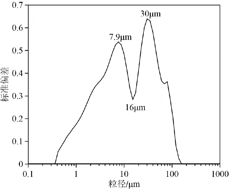
自然条件下物源和沉积动力都具有复杂性,因此常规粒度划分可能无法准确揭示沉积区物质来源和搬运动力变化。目前采用较为广泛的粒度分析方法有端元法[32]、组分分析法[33]、粒级-敏感组分法[34]等,可以一定程度上辅助解译沉积古环境。相较黄土和湖沼沉积,洪水沉积属快速堆积过程,时间尺度上物质来源较为一致,但流速变化较快,并不是所有粒级组分都对环境变化有明显响应[35],如对水流流速敏感的粒径范围可能很小[36-37]。鉴于洪水沉积这些特征,本文选择粒级-标准偏差法,从粒度数据中提取水动力敏感组分[38],并进一步解译其动力学过程。粒级-标准偏差曲线可以反映每个粒级组分的标准偏差随粒级的变化,标准偏差值越高,表明所对应粒级组分含量离散度越大,即为环境敏感组分[39]。MH1孔洪水沉积层18个样品标准偏差曲线大致以16 μm为界线,呈典型双峰分布(图6),峰值分别为0.54和0.64,对应粒径即为敏感组分:组分1(C1,7.9 μm),组分2(C2,30.0 μm)。C1属于细粉砂组分,能在水体中较长时间悬浮,理论上可存在于所有动力类型的水体环境中,但通常只在弱水动力条件下才能稳定沉积,因此可指示沉积环境稳定性[40]。C2属于中粉砂,为跳跃-悬浮组分,可指示粗粒物质的输入与水动力大小。
![]() 图 6 MH1钻孔洪水沉积物粒度敏感组分Figure 6. Sensitive grain-size components of the flood sediments of MH1 core
图 6 MH1钻孔洪水沉积物粒度敏感组分Figure 6. Sensitive grain-size components of the flood sediments of MH1 core4.2.2 水动力过程重建
提取洪水沉积层敏感组分C1与C2含量并绘制变化曲线(图7),两者具有显著镜像相关关系,表明受同一水动力因子控制,而且该控制因子使两个敏感组分含量朝相反方向变化。总体来看,C1含量呈增加趋势,C2含量波动减少。具体来看,可以划分为5个阶段,对应此次洪水过程的5个时期。
![]() 图 7 MH1钻孔粒度敏感组分含量变化特征与洪水阶段划分Figure 7. Results of sensitive grain-size components contents of flood layer in MH1 core and the division of flood stage
图 7 MH1钻孔粒度敏感组分含量变化特征与洪水阶段划分Figure 7. Results of sensitive grain-size components contents of flood layer in MH1 core and the division of flood stage阶段Ⅰ:9.5~9 cm,洪水初期,水位上涨淹没钻孔位置并开始洪水沉积。C1含量迅速升高并达到洪水层第一个峰值,C2含量则相对处于低值,反映洪水初期水位上升但流速并未同步加快。一方面与初期洪水强度较弱有关,另一方面可能反映了气候干旱化及人地矛盾突出背景下,人为活动阻滞了河水自由流动[41-42]。洪水发生前,MH1孔周围农田种植玉米,北侧为养殖场(图1c),行洪河道被严重侵占,影响洪水流动。
阶段Ⅱ:9~7.5 cm,第一次洪峰过程,C1含量有所下降,C2含量上升,达到洪水沉积层第一个峰值,也是最高值,表明该阶段流速显著加快,指示此次洪水的第一次洪峰过程,输入到钻孔位置的C2组分增多,同时强水动力环境使C1组分沉积量减少。
阶段Ⅲ:7.5~3 cm,高水位沉积阶段,经过阶段Ⅱ第一次洪峰过程,洪水上涨到高水位,但由于自然和人为双重因素影响,滞流现象严重[8],机械沉积分异作用主导该阶段沉积过程,粗粒组分沉积快于细粒组分,表现为C2所占比重逐渐减少,C1含量则波动升高,表明该阶段弥河下游在2018年洪水事件中经历了较长时间高水位滞流期。
阶段Ⅳ:3~1 cm,第二次洪峰过程,C1含量先快速下降后逐步回升,C2含量出现峰值,指示第二次水动力显著增强过程,可能对应第二次洪峰。
阶段Ⅴ:1~0 cm,退水过程,C1含量减少,C2含量略有增加,表明沉积动力短暂加强。揭示洪水末期快速退水过程中,钻孔位置水体流动性加强,细粒组分缺乏,粗粒组分含量相对增加。从该阶段沉积特征分析,洪水退水过程迅速,其中人为疏导排水起了重要作用。
4.3 烧失量、磁化率与粒度相关性分析
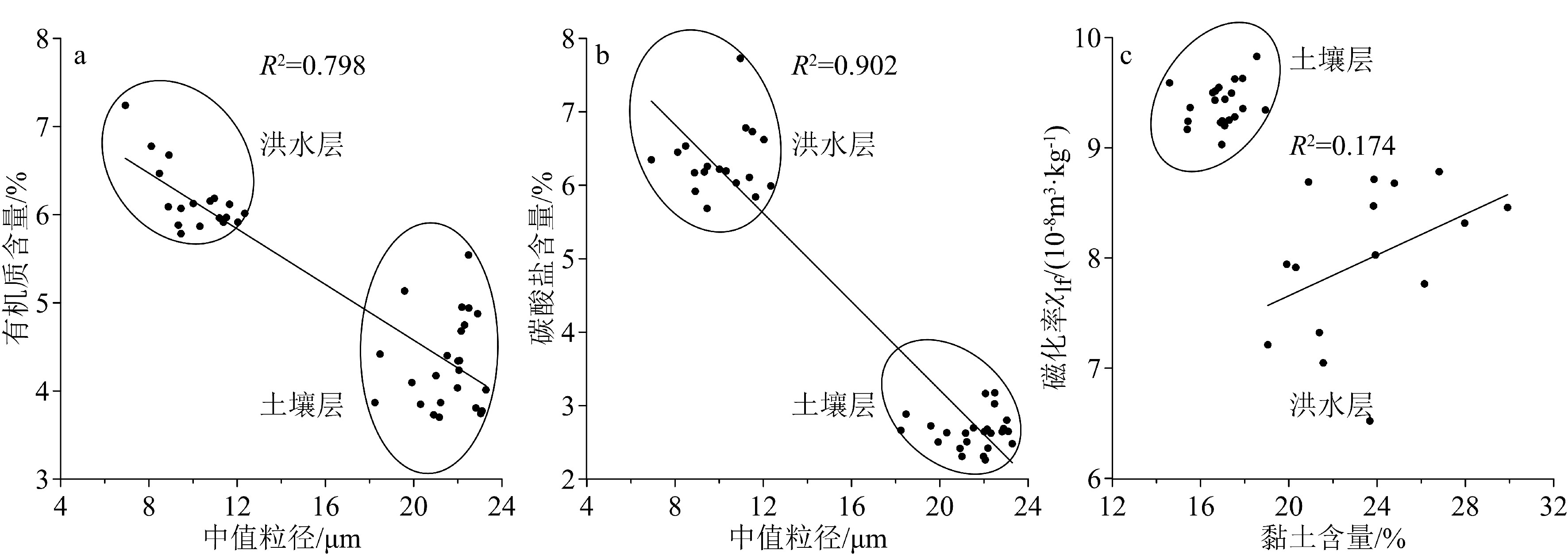
钻孔土壤层平均有机质含量为4.4%(表1),符合华北平原地区土壤有机质含量背景值[43]。洪水层有机质、碳酸盐含量均明显高于土壤层(图4a—b),与粒度负相关关系显著(图8a—b)。弥河上游地区以林地为主,地表有机质含量丰富,为洪水及其沉积物提供了充足的有机质来源,而且,有机颗粒比重较轻,在弱水动力条件下才能稳定沉积[44-46],粒度特征显示钻孔位置流速较慢,具备其富集并存储的沉积环境。而外源碳酸盐一般富集在黏土矿物中,粒度越细,其含量越高[47-48]。因此,水动力强度决定了洪水层碳酸盐和有机质含量,水流流速越快,粒度越大,烧失量越低;水动力越弱,粒度越细,烧失量越高。但洪水层与接触土壤层烧失量多寡关系并非由水动力单一因素控制,还取决于土壤层特征。
![]() 图 8 MH1钻孔烧失量、磁化率与中值粒径相关关系散点图Figure 8. Correlation between ignition loss, magnetic susceptibility and median grain size of MH1 core
图 8 MH1钻孔烧失量、磁化率与中值粒径相关关系散点图Figure 8. Correlation between ignition loss, magnetic susceptibility and median grain size of MH1 coreMH1孔磁化率与粒度相关关系不显著,土壤层磁化率值整体明显高于上覆洪水沉积层,仅就洪水层而言,其磁化率值与黏土含量正相关(图4c,图8c)。黄土和古洪水地层研究认为,古土壤层在成壤过程中就地产生细粒磁铁矿,因而磁化率明显高于其接触黄土层和洪水沉积层[49]。弥河流域现代洪水层磁化率研究结果支持了这一观点,但洪水沉积物磁化率在后期成壤作用之下如何表现需要进一步研究,其适用的地理空间范围也有待探讨。
4.4 洪水层与土壤层孢粉特征差异分析
孢粉含量及其组合特征可作为划分地层中洪水沉积旋回的可靠代用指标,并且已经在黄河和长江流域古洪水研究中取得研究案例[5,50]。洪水泛滥期间河流从区域外带来的孢粉类型与本土植物组成存在一定差异[51],孢粉丰度也通常高于洪水间歇期沉积[52],且同期洪水沉积层顶部孢粉丰度明显高于底部[53]。
此次弥河流域洪水持续时间仅数天,大气孢粉沉降的窗口期很短,贡献相对有限,因此可认为洪水层孢粉全部来自中上游地区,由水力搬运而来,而土壤层孢粉主要来自当地植物生产与区域内风力传输[54]。于洪水层和土壤层各取两个样品进行孢粉分析,对比孢粉特征差异。洪水层共鉴定出孢粉35个科属,土壤层鉴定出34种,且两个层位花粉科属种类几乎一致(图5),表明两者虽然孢粉沉积机制不同,但来源较为一致,原因之一弥河为小流域,上下游植物种类相差不大,其二上游地区植物花粉可通过风和水媒介搬运到下游河漫滩地区[54],这与长江、黄河等大河流域洪水沉积地层中孢粉特征存在一定差别[51-52]。
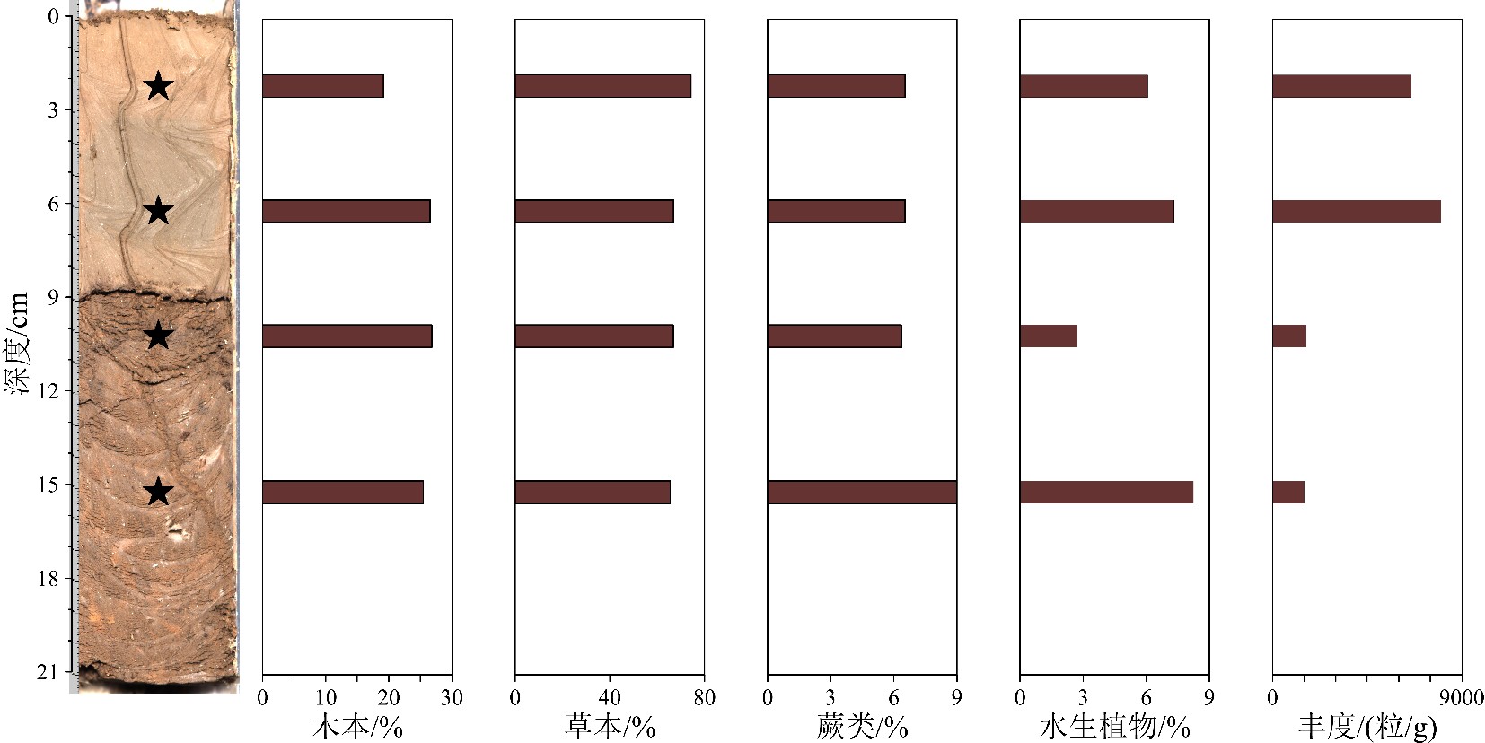
取孢粉丰度及木本、草本、蕨类、水生植物百分比等5个指标对比洪水层与土壤层孢粉差异(图9)。MH1孔洪水层草本植物花粉含量(70.61%)略高于土壤层(66.18%),木本植物花粉含量略低(22.85%~26.14%),10~10.5 cm处木本花粉含量最高(26.82%),可能因为该处是洪水层掩盖之前的土壤暴露面,随风携带而来的松属花粉含量最高(15.00%)。洪水层水生植物花粉含量为6.69%,比土壤层稍高(5.48%),水生植物花粉可通过多种途径富集于河流两侧河漫滩及冲积平原地区[54-55],因此无法作为区分洪水层与土壤层的标志。洪水层中的孢粉丰度(7313.96粒/g)远高于土壤层(1562.65粒/g),一方面因为钻孔位置水动力较弱,细颗粒物质沉积速度较慢,有利于孢粉沉降;另一方面可能与洪水层沉积物粒径小,更有利于孢粉存储有关[50,53]。
![]() 图 9 MH1钻孔孢粉种类与浓度分布图★号表示取样位置。Figure 9. Distribution and concentration of pollen species in MH1 core
图 9 MH1钻孔孢粉种类与浓度分布图★号表示取样位置。Figure 9. Distribution and concentration of pollen species in MH1 core5. 结论
(1)沉积剖面洪水层粒度较细,以黏土和细粉砂为主,揭示此次洪水强度不大,反映了小流域下游洪泛平原区的洪水水文特征。洪水沉积层粒度可识别出7.9 和30.0 μm两个敏感组分,根据其含量变化特征,可将此次洪水过程划分为洪水初期、第一次洪峰、高水位期、第二次洪峰、退水期5个阶段。
(2)洪水沉积层烧失量明显高于土壤层,一方面是弱水动力环境有利于有机颗粒和碳酸盐沉积,另一方面与土壤层较低的烧失量背景值有关。
(3)洪水层孢粉组合与土壤层并无明显差异,基本与流域植被状况相吻合,但孢粉丰度洪水层(7313.96粒/g)远高于土壤层(1562.65粒/g),揭示弱洪水动力条件对孢粉具有一定富集作用。
(4)剖面下伏土壤层磁化率值整体高于洪水层,可能与成壤过程中磁性矿物的产生与积累有关,可作为识别古洪水层的参考指标,但其适用地理空间范围有待进一步探讨。
致谢:云南师范大学博士研究生孙启发协助完成孢粉提取工作,两位审稿专家悉心审阅并提出建设性意见,在此一并致谢。
-
![]()
图 1 弥河下游流域及钻孔位置
a. 弥河流域位置图,b. 弥河下游流域图,c. 采样点位置遥感图,d. MH1钻孔岩芯图。
Figure 1. Location of the downstream of Mi river and the drilling point
a. Location of Mi River basin, b. The lower reaches of Mi River, c. Location of sampling site, d. The lithology of MH1 core.
![]()
图 2 MH1钻孔粒度参数及组分随深度变化曲线
Figure 2. Curves of grain size parameters and components with depth in MH1 core
![]()
图 3 MH1钻孔洪水沉积层平均粒度频率曲线(a)与概率累积曲线(b)
Figure 3. Distribution frequency(a) and probability accumulation curves(b) of the flood deposits in the MH1 core
![]()
图 4 MH1孔烧失量、磁化率变化曲线
Figure 4. Curves of ignition loss and magnetic susceptibility of MH1 core
![]()
图 6 MH1钻孔洪水沉积物粒度敏感组分
Figure 6. Sensitive grain-size components of the flood sediments of MH1 core
![]()
图 7 MH1钻孔粒度敏感组分含量变化特征与洪水阶段划分
Figure 7. Results of sensitive grain-size components contents of flood layer in MH1 core and the division of flood stage
![]()
图 8 MH1钻孔烧失量、磁化率与中值粒径相关关系散点图
Figure 8. Correlation between ignition loss, magnetic susceptibility and median grain size of MH1 core
![]()
图 9 MH1钻孔孢粉种类与浓度分布图
★号表示取样位置。
Figure 9. Distribution and concentration of pollen species in MH1 core
表 1 MH1孔各指标参数数值
Table 1 Values of index parameters of MH1 core
深度/cm 中值粒径/μm 黏土含量/% 砂含量
/%有机质含量
/%碳酸盐含量
/%磁化率χlf
/(10−8 m3/kg)孢粉丰度
/(粒/g)0~0.5 6.93 32.21 0.03 7.24 6.35 8.03 0.5~1 8.12 23.92 0.62 6.77 6.45 1~1.5 8.48 27.97 0.23 6.47 6.54 8.32 1.5~2 10.02 26.14 0.27 6.13 6.22 7.76 2~2.5 9.45 29.91 0.95 5.78 5.68 8.46 6608.14 2.5~3 8.92 23.86 2.38 6.68 5.92 8.71 3~3.5 8.88 27.27 1.64 6.09 6.17 8.47 3.5~4 9.46 23.84 2.57 6.07 6.26 4~4.5 9.33 26.82 0.90 5.88 6.18 8.78 4.5~5 10.77 20.90 2.69 6.15 6.03 8.69 5~5.5 10.31 24.78 3.10 5.87 6.19 8.68 5.5~6 11.38 20.31 3.34 5.91 6.11 7.91 6~6.5 11.65 19.90 2.99 6.12 5.84 7.94 8019.79 6.5~7 12.34 19.05 3.13 6.01 5.99 7.21 7~7.5 12.03 21.38 0.79 5.92 6.62 7.32 7.5~8 11.51 21.56 2.69 5.97 6.73 7.05 8~8.5 11.20 23.67 0.42 5.96 6.78 6.52 8.5~9 10.96 21.15 2.41 6.18 7.73 9~9.5 24.81 15.73 14.35 6.40 7.55 6.48 9.5~10 22.49 17.21 12.21 4.94 3.17 10~10.5 22.07 16.98 14.15 4.34 3.17 9.25 1614.49 10.5~11 22.49 14.83 14.06 5.54 3.02 11~11.5 22.15 17.34 12.63 4.68 2.68 9.36 11.5~12 18.47 15.53 11.66 4.42 2.89 9.20 12~12.5 19.59 17.09 13.34 5.13 2.72 9.23 12.5~13 22.89 16.91 13.14 4.88 2.69 9.63 13~13.5 21.52 17.90 11.40 4.40 2.70 9.52 13.5~14 23.28 16.67 13.18 4.01 2.48 9.24 14~14.5 22.83 15.43 13.52 3.81 2.65 9.03 14.5~15 20.91 16.96 13.04 3.73 2.42 9.55 15~15.5 22.31 16.82 10.63 4.75 2.62 9.43 1510.82 15.5~16 22.18 16.65 14.69 4.95 2.42 9.62 16~16.5 21.99 17.55 13.58 4.03 2.31 9.50 16.5~17 19.92 17.41 11.01 4.10 2.50 9.83 17~17.5 21.00 18.55 12.57 4.17 2.31 9.25 17.5~18 21.23 17.29 13.04 3.87 2.51 9.17 18~18.5 21.17 15.40 14.43 3.70 2.63 9.34 18.5~19 20.31 18.93 10.80 3.85 2.63 9.44 19~19.5 23.10 17.11 12.39 3.77 2.65 9.28 19.5~20 22.01 17.54 10.67 4.34 2.64 9.36 20~20.5 22.05 17.91 13.57 4.23 2.26 9.59 20.5~21 18.24 14.59 11.86 3.87 2.66 9.50 21~21.5 23.04 16.55 13.63 3.74 2.80 9.04  下载: 导出CSV
-
[1] 白九江, 邹后曦, 朱诚. 玉溪遗址古洪水遗存的考古发现和研究[J]. 科学通报, 2008, 53(S1):18-27 BAI Jiujiang, ZOU Houxi, ZHU Cheng. Archaeological discovery and research on the remains of the paleoflood of the Yuxi site [J]. Chinese Science Bulletin, 2008, 53(S1): 18-27.
[2] 李兰, 白九江, 代玉彪. 重庆永川汉东城遗址地层记录的长江上游唐代洪水事件[J]. 第四纪研究, 2020, 40(2):556-567 doi: 10.11928/j.issn.1001-7410.2020.02.24 LI Lan, BAI Jiujiang, DAI Yubiao. Flood event recorded by the layer of Handongcheng site and its significance to the upper reaches of Yangtze River [J]. Quaternary Sciences, 2020, 40(2): 556-567. doi: 10.11928/j.issn.1001-7410.2020.02.24
[3] Zhang L H, Zhang Z K, Chen Y Y, et al. Sediment characteristics, floods, and heavy metal pollution recorded in an overbank core from the lower reaches of the Yangtze River [J]. Environmental Earth Sciences, 2015, 74(11): 7451-7465. doi: 10.1007/s12665-015-4733-8
[4] Huang C C, Pang J L, Zha X C, et al. Extraordinary hydro-climatic events during the period AD 200−300 recorded by slackwater deposits in the upper Hanjiang River valley, China [J]. Palaeogeography, Palaeoclimatology, Palaeoecology, 2013, 374: 274-283. doi: 10.1016/j.palaeo.2013.02.001
[5] 朱诚, 马春梅, 王慧麟, 等. 长江三峡库区玉溪遗址T0403探方古洪水沉积特征研究[J]. 科学通报, 2008, 53(S1):1-17 ZHU Cheng, MA Chunmei, Xu Weifeng, et al. Characteristics of paleoflood deposits archived in unit T0403 of Yuxi Site in the Three Gorges Reservoir areas, China [J]. Chinese Science Bulletin, 2008, 53(S1): 1-17.
[6] 朱诚, 郑朝贵, 马春梅, 等. 长江三峡库区中坝遗址地层古洪水沉积判别研究[J]. 科学通报, 2005, 50(21):2493-2504 doi: 10.1007/BF03183641 ZHU Cheng, ZHENG Chaogui, MA Chunmei, et al. Identifying paleoflood deposits archived in Zhongba Site, the Three Gorges reservoir region of the Yangtze River, China [J]. Chinese Science Bulletin, 2005, 50(21): 2493-2504. doi: 10.1007/BF03183641
[7] Hattingh J, Zawada P K. Relief peels in the study of palaeoflood slack-water sediments [J]. Geomorphology, 1996, 16(2): 121-126. doi: 10.1016/0169-555X(95)00137-T
[8] Lam D, Croke J, Thompson C, et al. Beyond the gorge: palaeoflood reconstruction from slackwater deposits in a range of physiographic settings in subtropical Australia [J]. Geomorphology, 2017, 292: 164-177. doi: 10.1016/j.geomorph.2017.05.008
[9] 王慧颖, 王萍, 胡钢, 等. 溃决大洪水的地貌、沉积特征与水力学重建[J]. 第四纪研究, 2020, 40(5):1334-1349 doi: 10.11928/j.issn.1001-7410.2020.05.21 WANG Huiying, WANG Ping, HU Gang, et al. Landform, sedimentary features and hydraulic models of high-magnitude outburst flood [J]. Quaternary Sciences, 2020, 40(5): 1334-1349. doi: 10.11928/j.issn.1001-7410.2020.05.21
[10] 李长安, 黄俊华, 张玉芬, 等. 黄河上游末次冰盛期古洪水事件的初步研究[J]. 地球科学——中国地质大学学报, 2002, 27(4):456-458 LI Chang’an, HUANG Junhua, ZHANG Yufen, et al. Preliminary study of Paleoflood of last glacial maximum in upper reaches of the Yellow River [J]. Earth Science—Journal of China University of Geosciences, 2002, 27(4): 456-458.
[11] 王军, 高红山, 潘保田, 等. 早全新世沙沟河古洪水沉积及其对气候变化的响应[J]. 地理科学, 2010, 30(6):943-949 WANG Jun, GAO Hongshan, PAN Baotian, et al. Pleoflood sediment of Shagou river and its response to the climate change During early Holocene [J]. Scientia Geographica Sinica, 2010, 30(6): 943-949.
[12] 张玉芬, 李长安, 陈亮, 等. 基于磁组构特征的江汉平原全新世古洪水事件[J]. 地球科学——中国地质大学学报, 2009, 34(6):985-992 doi: 10.3799/dqkx.2009.112 ZHANG Yufen, LI Chang’an, CHEN Liang, et al. Magnetic fabric of holocene palaeo-floods events in Jianghan plain [J]. Earth Science—Journal of China University, 2009, 34(6): 985-992. doi: 10.3799/dqkx.2009.112
[13] 张强, 姜彤, 施雅风, 等. 6 000a BP以来长江下游地区古洪水与气候变化关系初步研究[J]. 冰川冻土, 2003, 25(4):368-374 ZHANG Qiang, JIANG Tong, SHI Yafeng, et al. Relationship between climate changes and the flood occurrences since 6 000 a BP in the Yangtze River Delta [J]. Journal of Glaciology and Geocryology, 2003, 25(4): 368-374.
[14] 朱诚, 张芸, 张强, 等. 江苏江阴祁头山新石器时代遗址考古地层研究[J]. 地层学杂志, 2003, 27(4):314-317,323 doi: 10.3969/j.issn.0253-4959.2003.04.008 ZHU Cheng, ZAHNG Yun, ZHANG Qiang, et al. Research on the archaeological strata of the Qitoushan neolithic site, Jiangyin, Jiangsu Province [J]. Journal of Stratigraphy, 2003, 27(4): 314-317,323. doi: 10.3969/j.issn.0253-4959.2003.04.008
[15] Xie S C, Pancost R D, Chen L, et al. Microbial lipid records of highly alkaline deposits and enhanced aridity associated with significant uplift of the Tibetan Plateau in the late Miocene [J]. Geology, 2012, 40(4): 291-294. doi: 10.1130/G32570.1
[16] 张凌华, 张振克. 河漫滩沉积与环境研究进展[J]. 海洋地质与第四纪地质, 2015, 35(5):153-163 ZHANG Linghua, ZHANG Zhenke. Research progress of river overbank deposits and implications for environment [J]. Marine Geology & Quaternary Geology, 2015, 35(5): 153-163.
[17] 吴庆龙, 赵志军, 刘莉, 等. 公元前1920年溃决洪水为中国大洪水传说和夏王朝的存在提供依据[J]. 中国水利, 2017(3):1-5 doi: 10.3969/j.issn.1000-1123.2017.03.002 WU Qinglong, ZHAO Zhijun, LIU Li, et al. Outburst flood at 1920 BC supports historicity of China's Great Flood and the Xia dynasty [J]. China Water Resources, 2017(3): 1-5. doi: 10.3969/j.issn.1000-1123.2017.03.002
[18] Dong G H, Zhang F Y, Liu F W, et al. Multiple evidences indicate no relationship between prehistoric disasters in Lajia site and outburst flood in upper Yellow River valley, China [J]. Science China Earth Sciences, 2018, 61(4): 441-449. doi: 10.1007/s11430-017-9079-3
[19] 李长安, 张玉芬, 袁胜元, 等. 江汉平原洪水沉积物的粒度特征及环境意义: 以2005年汉江大洪水为例[J]. 第四纪研究, 2009, 29(2):276-281 doi: 10.3969/j.issn.1001-7410.2009.02.11 LI Chang’an, ZHANG Yufen, YUAN Shengyuan, et al. Grain size characteristics and environmental significance of Hanjiang 2005 flood sediments [J]. Quaternary Sciences, 2009, 29(2): 276-281. doi: 10.3969/j.issn.1001-7410.2009.02.11
[20] Sheffer N A, Rico M, Enzel Y, et al. The Palaeoflood record of the Gardon River, France: a comparison with the extreme 2002 flood event [J]. Geomorphology, 2007, 98(1-2): 71-83.
[21] 伍俊斌, 刘雷震, 田丰, 等. 面向重大洪涝灾害应急响应的灾情动态评估方法研究: 以2018年8月山东寿光洪涝灾害为例[J]. 北京师范大学学报:自然科学版, 2020, 56(6):846-855 WU Junbin, LIU Leizhen, TIAN Feng, et al. Dynamic emergency assessment of flood disaster with emergency disaster index: case of Shouguang, Shandong Province in August, 2018 [J]. Journal of Beijing Normal University:Natural Science, 2020, 56(6): 846-855.
[22] 黄振国, 陈仲新, 刘芳清, 等. 基于HJ-1影像的大棚菜地遥感监测技术研究: 以山东寿光市为例[J]. 中国农业资源与区划, 2013, 34(5):102-106 doi: 10.7621/cjarrp.1005-9121.20130516 HUANG Zhenguo, CHEN Zhongxin, LIU Fangqing, et al. Monitoring of greenhouse vegetables land using HJ-1 remotely-sensed imagery [J]. Chinese Journal of Agricultural Resources and Regional Planning, 2013, 34(5): 102-106. doi: 10.7621/cjarrp.1005-9121.20130516
[23] 李华勇, 唐倩玉, 张虎才, 等. MS2000激光粒度仪测量第四纪沉积物粒度的定量进样研究[J]. 海洋地质与第四纪地质, 2020, 40(2):200-207 LI Huayong, TANG Qianyu, ZHANG Hucai, et al. Quantitative sampling for grain size analysis by MS2000 laser analyzer [J]. Marine Geology & Quaternary Geology, 2020, 40(2): 200-207.
[24] 丁喜桂, 叶思源, 宫少军, 等. 黄河三角洲ZK1孔岩心环境敏感粒度组分及沉积环境分析[J]. 世界地质, 2010, 29(4):575-581 doi: 10.3969/j.issn.1004-5589.2010.04.007 DING Xigui, YE Siyuan, GONG Shaojun, et al. Analysis on environmentally sensitive grain-size population and sedimentary environment of ZK1 drilling core in Yellow River delta [J]. Global Geology, 2010, 29(4): 575-581. doi: 10.3969/j.issn.1004-5589.2010.04.007
[25] 胡彩莉, 马玉贞, 郭超, 等. 烧失量法测定土壤有机质含量的实验条件探究[J]. 地球与环境, 2016, 44(1):110-118 HU Caili, MA Yuzhen, GUO Chao, et al. Optimization of the experiment conditions for estimating organic matter content with loss-on-ignition method [J]. Earth and Environment, 2016, 44(1): 110-118.
[26] 张文河, 穆桂金. 烧失法测定有机质和碳酸盐的精度控制[J]. 干旱区地理, 2007, 30(3):455-459 doi: 10.3321/j.issn:1000-6060.2007.03.021 ZHANG Wenhe, MU Guijin. Precision control on measuring organic and carbonate content with loss on ignition method [J]. Arid Land Geography, 2007, 30(3): 455-459. doi: 10.3321/j.issn:1000-6060.2007.03.021
[27] 王喜生, 杨振宇, Løvlie R, 等. 黄土高原东南缘黄土-古土壤序列的环境磁学结果及其古气候意义[J]. 科学通报, 2006, 51(22):2755-2762 doi: 10.1007/s11434-006-2192-z WANG Xisheng, YANG Zhenyu, Løvlie R, et al. Environmental magnetism and paleoclimatic interpretation of the Sanmenxia loess-paleosol sequence in the southeastern extremity of the Chinese Loess Plateau [J]. Chinese Science Bulletin, 2006, 51(22): 2755-2762. doi: 10.1007/s11434-006-2192-z
[28] 李春海, 何翠玲. 黄土孢粉HF处理方法[J]. 微体古生物学报, 2004, 21(3):346-348 doi: 10.3969/j.issn.1000-0674.2004.03.012 LI Chunhai, HE Cuiling. Preparation technique of HF treatment for extracting pollen and spores from loess sediments [J]. Acta Micropalaeontologica Sinica, 2004, 21(3): 346-348. doi: 10.3969/j.issn.1000-0674.2004.03.012
[29] McManus J. Grain size determination and interpretation[M]//Tucker M. Techniques in Sedimentology. Oxford: Blackwell, 1988: 63-85.
[30] 黄春长, 庞奖励, 查小春, 等. 黄河流域关中盆地史前大洪水研究: 以周原漆水河谷地为例[J]. 中国科学:地球科学, 2011, 41(11):1658-1669 doi: 10.1360/zd-2011-41-11-1658 HUANG Chunchang, PANG Jiangli, ZHA Xiaochun, et al. Prehistorical floods in the Guanzhong Basin in the Yellow River drainage area: a case study along the Qishuihe River valley over the Zhouyuan Loess Tableland [J]. Scientia Sinica Terrae, 2011, 41(11): 1658-1669. doi: 10.1360/zd-2011-41-11-1658
[31] 张跞颖, 李长安, 张玉芬, 等. 长江武汉段4.5~2.5 ka沉积地层与古洪水标志识别[J]. 地质论评, 2019, 65(4):973-982 ZHANG Luoying, LI Chang’an, ZHANG Yufen, et al. Sedimentary strata and paleoflood identification indexes of Wuhan section, Yangtze River, during 4.5~2.5 ka BP [J]. Geological Review, 2019, 65(4): 973-982.
[32] Yu S Y, Colman S M, Li L X. BEMMA: a hierarchical Bayesian end-member modeling analysis of sediment grain-size distributions [J]. Mathematical Geosciences, 2016, 48(6): 723-741. doi: 10.1007/s11004-015-9611-0
[33] Qin X G, Cai B G, Liu T. Loess record of the aerodynamic environment in the east Asia monsoon area since 60, 000 years before present [J]. Journal of Geophysical Research, 2005, 110(B1): B01204.
[34] Boulay S, Colin C, Trentesaux A, et al. Mineralogy and sedimentology of Pleistocene sediment in the South China Sea (ODP Site 1144)[M]//Prell W L, Wang P, Blum P, et al. Proceedings of the Ocean Drilling Program, Scientific Results. 2003: 1-21.
[35] 万世明, 李安春, Stuut J B W, 等. 南海北部ODP1146站粒度揭示的近20 Ma以来东亚季风演化[J]. 中国科学 D辑:地球科学, 2007, 50(10):1536-1547 doi: 10.1007/s11430-007-0082-0 WAN Shiming, LI Anchun, Stuut J B W, et al. Grain-size records at ODP site 1146 from the northern South China Sea: implications on the East Asian monsoon evolution since 20 Ma [J]. Science in China Series D:Earth Sciences, 2007, 50(10): 1536-1547. doi: 10.1007/s11430-007-0082-0
[36] 陈桥, 刘东艳, 陈颖军, 等. 粒级-标准偏差法和主成分因子分析法在粒度敏感因子提取中的对比[J]. 地球与环境, 2013, 41(3):319-325 CHEN Qiao, LIU Dongyan, CHEN Yingjun, et al. Comparative analysis of grade-standard deviation method and factors analysis method for environmental sensitive factor analysis [J]. Earth and Environment, 2013, 41(3): 319-325.
[37] de Mahiques M M, Goya S C, da Silva Nogueira de Matos M C, et al. Grain-size end-members and environmentally sensitive grain-size components: a comparative study in the mud shelf depocenters off southern Brazil [J]. International Journal of Sediment Research, 2021, 36(2): 317-327. doi: 10.1016/j.ijsrc.2020.07.004
[38] Ma L, Abuduwaili J, Liu W. Environmentally sensitive grain-size component records and its response to climatic and anthropogenic influences in Bosten Lake region, China [J]. Scientific Reports, 2020, 10(1): 942. doi: 10.1038/s41598-020-57921-y
[39] 赵西西, 王天阳, 朱丽东, 等. 庐山JL剖面粒度敏感组分的提取与环境意义初探[J]. 地理与地理信息科学, 2015, 31(2):115-118,124 doi: 10.3969/j.issn.1672-0504.2015.02.023 ZHAO Xixi, WANG Tianyang, ZHU Lidong, et al. Extraction of environmentally sensitive grain size group from JL section and initial exploration of its environmental significance [J]. Geography and Geo-Information Science, 2015, 31(2): 115-118,124. doi: 10.3969/j.issn.1672-0504.2015.02.023
[40] 肖舜, 周爱锋, 黄小忠, 等. 柴达木盆地表土与大气降尘粒度Weibull组成及其环境意义[J]. 中国沙漠, 2012, 32(5):1193-1200 XIAO Shun, ZHOU Aifeng, HUANG Xiaozhong, et al. Grain-size Weibull composition of surface dust deposits and atmospheric dustfall, and their environmental implications in Qaidam basin, China [J]. Journal of Desert Research, 2012, 32(5): 1193-1200.
[41] 邓慧平, 李爱贞, 刘厚风, 等. 气候波动对莱州湾地区水资源及极端旱涝事件的影响[J]. 地理科学, 2000, 20(1):56-60 doi: 10.3969/j.issn.1000-0690.2000.01.010 DENG Huiping, LI Aizhen, LIU Houfeng, et al. Impacts of climate fluctuations on water resources and extremes in the Laizhou Bay area [J]. Scientia Geographica Sinica, 2000, 20(1): 56-60. doi: 10.3969/j.issn.1000-0690.2000.01.010
[42] Grill G, Lehner B, Thieme M, et al. Mapping the world’s free-flowing rivers [J]. Nature, 2019, 569(7755): 215-221. doi: 10.1038/s41586-019-1111-9
[43] 俞海, 黄季焜, Rozelle S, 等. 中国东部地区耕地土壤肥力变化趋势研究[J]. 地理研究, 2003, 22(3):380-388 doi: 10.3321/j.issn:1000-0585.2003.03.015 YU Hai, HUANG Jikun, Rozelle S, et al. Soil fertility changes of cultivated land in Eastern China [J]. Geographical Research, 2003, 22(3): 380-388. doi: 10.3321/j.issn:1000-0585.2003.03.015
[44] 李华, 杨世伦, Ysebaert T, 等. 长江口潮间带淤泥质沉积物粒径空间分异机制[J]. 中国环境科学, 2008, 28(2):178-182 doi: 10.3321/j.issn:1000-6923.2008.02.017 LI Hua, YANG Shilun, Ysebaert T, et al. Spatial difference mechanism of sludge sediment grain size in tidal wetlands of Yangtze delta [J]. China Environmental Science, 2008, 28(2): 178-182. doi: 10.3321/j.issn:1000-6923.2008.02.017
[45] 杨冰洁, 余凤玲, 郑卓, 等. 南澳岛青澳湾沉积物粒度与烧失量指示的全新世沉积环境变化[J]. 海洋地质与第四纪地质, 2015, 35(6):41-51 YANG Bingjie, YU Fengling, ZHENG Zhuo, et al. Changes in Holocene depositional environment of Qin′ao embayment on Nan′ao island inferred from sediment grain-size and loss-on-ignition [J]. Marine Geology & Quaternary Geology, 2015, 35(6): 41-51.
[46] 蔡进功, 曾翔, 韦海伦, 等. 从水体到沉积物: 探寻有机质的沉积过程及其意义[J]. 古地理学报, 2019, 21(1):49-66 doi: 10.7605/gdlxb.2019.01.003 CAI Jingong, ZENG Xiang, WEI Hailun, et al. From water body to sediments: Exploring the depositional processes of organic matter and their implications [J]. Journal of Palaeogeography (Chinese Edition), 2019, 21(1): 49-66. doi: 10.7605/gdlxb.2019.01.003
[47] 何良彪. 黄河三角洲沿岸及邻近海区细粒沉积物中的碳酸盐[J]. 海洋科学, 1991(3):41-45 HE Liangbiao. Study of carbonate in the fine grained sediment from the coastal zone of the Huanghe delta and adjacent Bohai gulf [J]. Marine Sciences, 1991(3): 41-45.
[48] 王艳君, 金秉福. 黄河河口段与海河河口段沉积物碳酸盐对比分析[J]. 海洋科学, 2017, 41(7):94-104 doi: 10.11759/hykx20161208001 WANG Yanjun, JIN Bingfu. Comparative analysis of carbonates in sediments of the Yellow River and the Haihe River estuaries [J]. Marine Sciences, 2017, 41(7): 94-104. doi: 10.11759/hykx20161208001
[49] Maher B A, Taylor R M. Origin of soil magnetite [J]. Nature, 1989, 340(6229): 106. doi: 10.1038/340106c0
[50] Liu D X, Ma J H, Wu P F, et al. A new indicator for dividing sedimentary rhythms in alluvial deposits: a pollen-based method [J]. CATENA, 2020, 189: 104500. doi: 10.1016/j.catena.2020.104500
[51] 刘德新, 马建华, 谷蕾, 等. 全新世中后期开封西郊黄泛沉积序列的孢粉记录[J]. 地理学报, 2016, 71(5):852-863 doi: 10.11821/dlxb201605013 LIU Dexin, MA Jianhua, GU Lei, et al. The middle and late Holocene pollen record from the Yellow River flooding sedimentary sequence in the western suburbs of Kaifeng City, China [J]. Acta Geographica Sinica, 2016, 71(5): 852-863. doi: 10.11821/dlxb201605013
[52] 崔安宁, 马春梅, 朱诚, 等. 长江三峡库区玉溪遗址的环境与人类活动的孢粉记录[J]. 微体古生物学报, 2015, 32(2):161-173 CUI Anning, MA Chunmei, ZHU Cheng, et al. Pollen records of the Yuxi culture site in the three gorges reservoir area, Yangtze River [J]. Acta Micropalaeontologica Sinica, 2015, 32(2): 161-173.
[53] Long Y, Zhang X B, Li M, et al. Identification of the deposited layers in landslides reservoir and investigation of the sediment yields during the later sixteenth century on the Hill Loess Plateau, China [J]. Chinese Science Bulletin, 2008, 53(24): 3908-3913.
[54] 常婧, 惠争闯, 耿豪鹏, 等. 黑河中游现代孢粉传播过程研究[J]. 地理科学, 2017, 37(12):1925-1932 CHANG Jing, HUI Zhengchuang, GENG Haopeng, et al. Modern pollen transportation process in the middle reach of the Heihe River [J]. Scientia Geographica Sinica, 2017, 37(12): 1925-1932.
[55] 许清海, 王子惠, 朱宣清. 滹沱河饶阳段表土花粉的初步研究[J]. 河北省科学院学报, 1991(3):49-55 XU Qinghai, WANG Zihui, ZHU Xuanqing. Preliminary study on surface pollen in Raoyang section of the Hutuo river [J]. Journal of the Hebei Academy of Sciences, 1991(3): 49-55.
-
期刊类型引用(2)
1. 李明宸,闫粟,公力维,王雪晨,耿润玉,徐润喆,周亮,汪亚平,沈治雄. 2020年特大洪水期间长江水下三角洲沉积物沉积特征. 海洋地质与第四纪地质. 2025(02): 31-42 .  本站查看
本站查看
2. 张宏亮,侯依林,李华勇,李智慧,王倩,杨艺萍,许惟栋,于正松. 鲁北现代洪水沉积物XRF元素扫描特征及其指示意义. 海洋地质与第四纪地质. 2023(03): 185-194 . 本站查看
其他类型引用(1)


计量
- 文章访问数: 2134
- HTML全文浏览量: 655
- PDF下载量: 49
- 被引次数: 3