TOPOGRAPHIC CONSTRAINTS ON THE SUBDUCTION EROSION OF THE YAP ARC, WESTERN PACIFIC
-
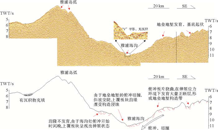
摘要: 俯冲侵蚀是一种将地壳及岛弧物质从弧前搬运走的地质过程,会导致弧前物质的缺失,这种地质过程普遍地出现在汇聚型板块边缘。雅浦海沟位于加罗林板块与菲律宾海板块之间,是一个活跃的俯冲带。利用2015年中科院海洋所在西太平洋雅浦海采集的最新的多波束和地震数据,给出了雅浦海沟发生俯冲侵蚀的直接证据:(1)雅浦海沟具有异常短的沟弧间距(41 km);(2)海沟呈不对称的“V”字形,增生楔缺失;(3)俯冲板片基底起伏程度大,加罗林洋底高原上洋脊、海山、地垒地堑构造发育;(4)海沟内壁斜坡较陡,弧前斜坡坡度的平均值约8.69°,雅浦海沟的弧前增生楔缺失。揭示了雅浦海沟南北两侧俯冲侵蚀模式的差异,北部的俯冲侵蚀主要由于洋底高原上地垒地堑与上覆板块的摩擦造成,板块之间可能不是直接接触,存在“剥蚀带”;南部的俯冲侵蚀主要由于洋底高原上的海山与上覆板块的摩擦造成,板块之间可能是直接接触的。Abstract: As a specific geological process, subduction erosion can move the substance of the earth crust and arc away from the forearc wedge and cause the missing of forearc crustal material, which generally occurs at the convergent plate boundaries. The Yap trench is an active subduction zone which is located at the convergence zone of the Caroline Plate and Philippine Sea Plate. According to the new multi-beam and seismic data that acquired by the integrated geophysical survey off the Yap Island, western Pacific, conducted by Institute of Oceanology, Chinese Academy of Sciences, we found evidence of erosion as follows: (1)The Yap trench has unusually short distance to the arc from the trench axis (41 km); (2)The cross-sections across the axis show asymmetry V-shape and the accretionary wedge is absent in the trench; (3)The relief of oceanic basement is severe, because ridges, sea mountains, structural belt of horst and graden exist in the oceanic plateaux of Caroline Plate; (4) The trench wall exhibits a steep slope and the mean forearc slope is 8.69° and the accretionary wedge is missing. We speculate that the mode of subduction erosion is different on both sides of the Yap trench. The subduction erosion of oceanic plateau in the northern Yap trench is mainly resulted from the friction between the structural belt of horst and graben and the overlying plate, and the structural belt of horst and graben initially might be filled with sediment, so there is a zone of basal erosion between the plates rather than direct contact; However, the subduction erosion of oceanic plateau in the southern Yap trench is mainly resulted from friction between the seamounts and overlying plate and the two plates contact directly.
-
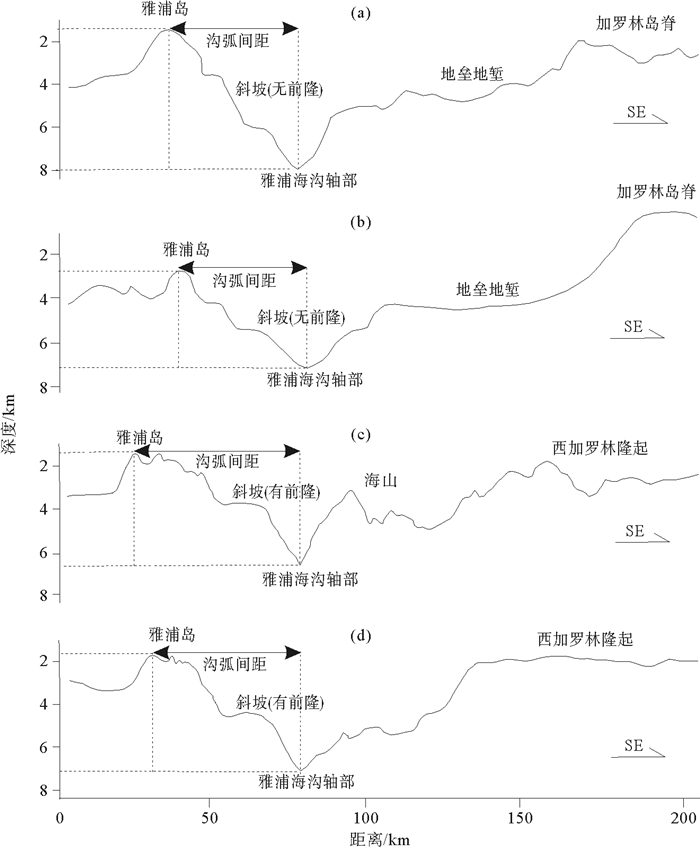
图 2 雅浦海沟北部(9°N以北地区)和南部(9°N以南地区)典型地形剖面图
(剖面a、b、c和d的海沟轴线位置分别为10°07′N、9°38′N、8°58′N和8°49′N,具体位置见图 1)
Figure 2. Typical bathymetric profiles around the northern Yap trench(to the north of 9°N in Yap trench)and the southern Yap trench(to the south of 9°N in Yap trench)
(The trench axis location of profiles a, b, c and d is 10°07′N, 9°38′N, 8°58′N and 8°49′N respectively. See Fig. 1 for the location of profiles)
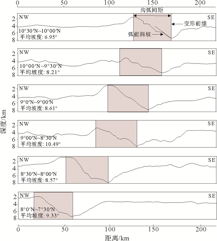
图 6 从北至南(10°30′~7°30′N)雅浦海沟地形深度剖面追踪
(在10°30′~7°30′N纬度范围内,每隔30′选取一个典型的地形剖面进行绘制,并计算弧前斜坡的平均坡度。可看出从北至南雅浦海沟岛弧一侧的斜坡有增大的趋势,这不仅暗示了雅浦海沟南北部俯冲开始时间的不同,也暗示了俯冲侵蚀方式的差异)
Figure 6. Bathymetric track across the Yap trench between 10°30′~7°30′N
(The mean frontal slope was calculated over the typical bathymetric profiles taken every 30 minutes latitude. Mean frontal slope gradually increased from the north to the south. It implied that the time of initial subduction and subduction erosion mode are different)
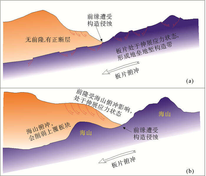
图 7 雅浦海沟北部和南部俯冲侵蚀模式
(参考Huene等[38]和Kukowski等[33]提出的俯冲侵蚀模式)。(a)雅浦海沟北部的俯冲侵蚀主要由于俯冲板块上的地垒地堑与上覆板块的摩擦造成,由于地垒地堑中会有沉积物充填,所以板块之间可能不是直接接触,存在“剥蚀带”;(b)雅浦海沟南部的俯冲侵蚀主要由于俯冲板块上的海山与上覆板块的摩擦造成,板块之间可能是直接接触的。
Figure 7. Subduction erosion mode in the northern and south Yap trench
(modified from Von Huene et al.[38]and Kukowski et al.[33]) (a)The subduction erosion in the northern Yap trench mainly resulted from friction between the structural belt of horst and graben and overlying plate. The structural belt of horst and graben initially might be filled with sediment, so there is a zone of basal erosion between the plate rather than direct contact; (b)The subduction erosion in the southern Yap trench mainly resulted from friction between the seamounts and overlying plate. The two plates contacted directly
-
[1] Kopp H, Flueh E R, Petersen C J, et al. The Java margin revisited: Evidence for subduction erosion off Java[J]. Earth & Planetary Science Letters, 2006, 242(1):130-142.
[2] Clift P, Vannucchi P. Controls on tectonic accretion versus erosion in subduction zones: Implications for the origin and recycling of the continental crust[J]. Reviews of Geophysics, 2004, 42(2):117-128. doi: 10.1029/2003rg000127
[3] Huene R V, Scholl D W. Observations at convergent margins concerning sediment subduction, subduction erosion, and the growth of continental crust. Rev Geophys[J]. Reviews of Geophysics, 1991, 29(3):279-316.
[4] Stern C R. Subduction erosion: Rates, mechanisms, and its role in arc magmatism and the evolution of the continental crust and mantle[J]. Gondwana Research, 2011, 20(2):284-308. doi: 10.1016/j.gr.2011.03.006
[5] Huene R V, Ranero C R, Vannucchi P. Generic model of subduction erosion[J]. Geology, 2004, 32(10):913-916. doi: 10.1130/G20563.1
[6] Scholl D W, Von Huene R. Implications of estimated magmatic additions and recycling losses at the subduction zones of accretionary (non-collisional) and collisional (suturing) orogens[J]. Geological Society London Special Publications, 2009, 318(1):105-125. doi: 10.1144/SP318.4
[7] Lee S M. Deformation from the convergence of oceanic lithosphere into Yap trench and its implications for early-stage subduction[J]. Journal of Geodynamics, 2004, 37(1):83-102. doi: 10.1016/j.jog.2003.10.003
[8] Fujiwara T.Morphology and tectonics of the Yap Trench[J]. Marine Geophysical Researches, 2000, 21(1):69-86. doi: 10.1023/a:1004781927661
[9] Hawkins J, Batiza R. Metamorphic rocks of the Yap arc-trench system[J]. Earth & Planetary Science Letters, 1977, 37(2):216-229. doi: 10.1016/0012-821x(77)90166-2
[10] Hayes D E. Hypothetical Model for the Bending of the Mariana Arc[M]. The Tectonic and Geologic Evolution of Southeast Asian Seas and Islands: Part 2. American Geophysical Union, 2013:281-293.
[11] Ohara Y, Fujioka K, Ishizuka O, et al. Peridotites and volcanics from the Yap arc system: implications for tectonics of the southern Philippine Sea Plate[J]. Chemical Geology, 2002, 189(1):35-53. doi: 10.1016/S0009-2541(02)00062-1
[12] Seno T, Stein S, Gripp A E. A model for the motion of the Philippine Sea Plate consistent with NUVEL-1 and geological data[J]. Journal of Geophysical Research Atmospheres, 1993, 98(B10):17941-17948. doi: 10.1029/93JB00782
[13] Nagihara S, Kinoshita M, Fujimoto H, et al. Geophysical observations around the northern Yap Trench: seismicity, gravity and heat flow[J]. Tectonophysics, 1989, 163(1-2):93-104. doi: 10.1016/0040-1951(89)90120-0
[14] Fujika, K, Kobayashi K, Fujiwara T, et al. Tectonics of the southern tip of the Philippine Sea: results of Southerncross' 95 cruise[J]. Jamstec J. Deep Sea, 1996, 12:275-290.
[15] Breitsprecher K, Thorkelson D J. Neogene kinematic history of Nazca-Antarctic-Phoenix slab windows beneath Patagonia and the Antarctic Peninsula[J]. Tectonophysics, 2009, 464(1-4):10-20. doi: 10.1016/j.tecto.2008.02.013
[16] Sato T, Matsu′Ura M. A kinematic model for evolution of island arc-trench systems[J]. Geophysical Journal International, 1993, 114(3):512-530. doi: 10.1111/j.1365-246X.1993.tb06984.x
[17] Fryer P, Sujimoto H, Sekine M, et al. Volcanoes of the southwestern extension of the active Mariana island arc: New swath-mapping and geochemical studies[J]. Island Arc, 2004, 7(3):596-607. doi: 10.1111/j.1440-1738.1998.00212.x
[18] Isozaki Y, Aoki K, Nakama T, et al. New insight into a subduction-related orogen: A reappraisal of the geotectonic framework and evolution of the Japanese Islands[J]. Gondwana Research, 2010, 18(1):82-105. doi: 10.1016/j.gr.2010.02.015
[19] Jacobson C E, Grove M, Pedrick J N, et al. Late Cretaceous-early Cenozoic tectonic evolution of the southern California margin inferred from provenance of trench and forearc sediments[J]. Geological Society of America Bulletin, 2011, 123(3/4):485-506. http://www.wanfangdata.com.cn/details/detail.do?_type=perio&id=ed2069950c2d410a3a67f84a203f53a5
[20] Kay S M, Godoy E, Kurtz A. Episodic arc migration, crustal thickening, subduction erosion, and magmatism in the south-central Andes[J]. Geological Society of America Bulletin, 2005, 117(1/2):67-88. doi: 10.1130-B25431.1/
[21] Kobayashi K. Origin of the Palau and Yap trench-arc systems[J]. Geophysical Journal International, 2004, 157(3):1303-1315. doi: 10.1111/j.1365-246X.2003.02244.x
[22] Fuller M, Haston R, Schmidtke E. Paleomagnetism in SE Asia: Sinistral Shear Between Philippine Sea Plate and Asia[M]// Paleomagnetic Rotations and Continental Deformation. 1989: 411-430.
[23] Haston R. Paleomagnetic results from Palau, West Caroline Islands: A constraint on Philippine Sea plate motion[J]. Geology, 1988, 16(16):654-657. doi: 10.1130/0091-7613(1988)0162.3.CO;2
[24] Kitada K, Seama N, Yamazaki T, et al. Distinct regional differences in crustal thickness along the axis of the Mariana Trough, inferred from gravity anomalies[J]. Geochemistry Geophysics Geosystems, 2006, 7(4):1-14. http://www.wanfangdata.com.cn/details/detail.do?_type=perio&id=10.1029/2005GC001119
[25] Ballance P F, Scholl D W, Vallier T L. Subduction of a late Cretaceous seamount of the Louisville ridge at the Tonga trench: A model of normal and accelerated tectonic erosion[J]. Tectonics, 1989, 8(5):953-962. doi: 10.1029/TC008i005p00953
[26] Altis S. Origin and tectonic evolution of the Caroline Ridge and the Sorol Trough, western tropical Pacific, from admittance and a tectonic modeling analysis[J]. Tectonophysics, 1999, 313(3):271-292. doi: 10.1016/S0040-1951(99)00204-8
[27] Hegarty K A, Weissel J K. Complexities in the Development of the Caroline Plate Region, Western Equatorial Pacific[M]// The Ocean Basins and Margins. Springer US, 1988: 277-301.
[28] Fornari D J, Weissel J K, Perfit M R, et al. Petrochemistry of the Sorol and Ayu Troughs: implications for crustal accretion at the northern and western boundaries of the Caroline plate[J]. Earth & Planetary Science Letters, 1979, 45(1):1-15. doi: 10.1016/0012-821X(79)90102-X
[29] Perfit M R, Fornari D J. Mineralogy and geochemistry of volcanic and plutonic rocks from the boundaries of the Caroline plate: Tectonic implications[J]. Tectonophysics, 1982, 87(1-4):279-313. doi: 10.1016/0040-1951(82)90230-X
[30] 陆鹿, 严立龙, 李秋环, 等.洋底高原及其对地球系统意义研究综述[J].岩石学报, 2016, 32(6):1851-1876. http://d.old.wanfangdata.com.cn/Periodical/ysxb98201606019 LU Lu, YAN Lilong, LI Qiuhuan, et al. Oceanic plateau and its significances on the Earth system: A review[J]. Acta Petrologica Sinica, 2016, 32(6):1851-1876. http://d.old.wanfangdata.com.cn/Periodical/ysxb98201606019
[31] Bracey D R, Andrews J E. Western Caroline Ridge: Relic island arc?[J]. Marine Geophysical Researches, 1974, 2(2):111-125. http://d.old.wanfangdata.com.cn/NSTLQK/NSTL_QKJJ0232162521/
[32] Weissel J K, Anderson R N. Is there a Caroline plate?[J]. Earth & Planetary Science Letters, 1978, 41(2):143-158. doi: 10.1016/0012-821X(78)90004-3
[33] Kukowski N, Oncken O. Subduction Erosion— the "Normal" Mode of Fore-Arc Material Transfer along the Chilean Margin?[M]. The Andes, 2006:217-236.
[34] Gao X, Wang K. Strength of stick-slip and creeping subduction megathrusts from heat flow observations[J]. Science, 2014, 345(6200):1038-41. doi: 10.1126/science.1255487
[35] Keating B H, Mattey D P, Helsley C E, et al. Evidence for a hot spot origin of the Caroline Islands[J]. Journal of Geophysical Research Atmospheres, 1984, 89(NB12):9937-9948. doi: 10.1029/JB089iB12p09937
[36] Cande S C, Leslie R B. Late Cenozoic tectonics of the Southern Chile Trench[J]. Journal of Geophysical Research, 1986, 91(91):471-496. doi: 10.1029/jb091ib01p00471
[37] Laursen J, Scholl D W, Huene R V. Neotectonic deformation of the central Chile margin: Deepwater forearc basin formation in response to hot spot ridge and seamount subduction[J]. Tectonics, 2002, 21(5):2-1. doi: 10.1029/2001TC901023
[38] Huene R V, Ranero C R, Vannucchi P. Generic model of subduction erosion[J]. Geology, 2004, 32(10):913-916. doi: 10.1130/G20563.1
[39] Hayes D E. The Tectonic and Geologic Evolution of Southeast Asian Seas and Islands[M]. The Tectonic and geologic evolution of Southeast Asian seas and islands. American Geophysical Union, 1980.
[40] Hilde T W C. Sediment subduction versus accretion around the pacific[J]. Tectonophysics, 1983, 99(2-4):381-397. doi: 10.1016/0040-1951(83)90114-2
[41] Lallemand S, Pichon X L. Coulomb wedge model applied to the subduction of seamounts in the Japan Trench[J]. Geology, 1987, 15(11):1065-1069. doi: 10.1130/0091-7613(1987)15<1065:CWMATT>2.0.CO;2
[42] Dupont J, Herzer R H. Effect of subduction of the Louisville Ridge on the Structure and Morphology of the Tonga Arc[C]//Geology and Offshore Resource of Pacific Island Arcs: Tonga Region. 1985: 323-332.
[43] Clift P, Vannucchi P. Controls on tectonic accretion versus erosion in subduction zones: Implications for the origin and recycling of the continental crust[J]. Reviews of Geophysics, 2004, 42(2):117-128. doi: 10.1029/2003rg000127
[44] Demets C, Gordon R G, Argus D F, et al. Effect of recent revisions to the geomagnetic reversal time scale on estimates of current plate motions[J]. Geophysical Research Letters, 1994, 21(20):2191-2194. doi: 10.1029/94GL02118
[45] Timm C, Davy B, Haase K, et al. Subduction of the oceanic Hikurangi Plateau and its impact on the Kermadec arc[J]. Wseas Transactions on Mathematics, 2014, 9(5):123-146. doi: 10.1038/ncomms5923
[46] Bassett D, Sutherland R, Henrys S, et al. Three-dimensional velocity structure of the northern Hikurangi margin, Raukumara, New Zealand: Implications for the growth of continental crust by subduction erosion and tectonic underplating[J]. Geochemistry Geophysics Geosystems, 2010, 11(10):155-162. doi: 10.1029/2010GC003137
[47] Bangs N L, Cande S C. Episodic development of a convergent margin inferred from structures and processes along the southern Chile margin[J]. Tectonics, 1997, 16(3):489-503. http://www.wanfangdata.com.cn/details/detail.do?_type=perio&id=10.1029/97TC00494
[48] Clift P D, Pecher I, Kukowski N, et al. Tectonic erosion of the Peruvian forearc, Lima Basin, by subduction and Nazca Ridge collision[J]. Tectonics, 2003, 22(3), 1023, doi:10.1029/2002TC 001386.
[49] Encinas A, Finger K L. Slow rates of subduction erosion and coastal underplating along the Andean margin of Chile and Peru: Comment and Reply: Comment[J]. Geology, 2007, 35(6):503-506. doi: 10.1130/G23584A.1
-
期刊类型引用(14)
1. 田兴雨, 孙承君, 闫艺心, 丁海兵. 雅浦海沟北部深渊沉积物中脂肪酸的分布特征. 海洋科学进展. 2025(03)  百度学术
百度学术
2. 黄彤宇,王强,杨宗永. 俯冲侵蚀的研究历史、现状与展望. 岩石学报. 2024(03): 719-740 .  百度学术
百度学术
3. 唐宇,王根厚,韩芳林,李典,梁晓,冯翼鹏,张莉,王卓胜,韩宁. 西藏加查地区特提斯喜马拉雅带晚三叠世地层重新厘定及构造变形研究. 地学前缘. 2023(02): 35-56 .  百度学术
百度学术
4. 刘喆昊,王冰,张建兴,宋永东,庄丽华,栾振东. 雅浦-卡罗琳海区精细地貌解译与分析. 海洋科学进展. 2023(03): 477-487 .  百度学术
百度学术
5. 韩潇,付永涛. 雅浦俯冲带北段地球物理场及构造活动性分析. 海洋科学进展. 2022(03): 449-460 .  百度学术
百度学术
6. 田原,陈灵,唐立梅,高鹏,方银霞. 西太平洋雅浦海沟地幔演化与岩浆作用研究进展. 地球科学. 2021(03): 840-852 .  百度学术
百度学术
7. 刘海洋,薛颖瑜,孙卫东. 勘察加岛弧岩浆岩研究进展. 岩石学报. 2020(02): 560-574 .  百度学术
百度学术
8. 陈康,徐继尚,李广雪,田举,杨继超,周尚,孙思婷. 雅浦海沟南缘海底表层矿物碎屑粒度特征及其物源指示. 海洋地质与第四纪地质. 2020(05): 46-57 .  本站查看
本站查看
9. 赵永芳,郑珊,孙晓霞. 2014年冬季热带西太平洋雅浦Y3海山光合色素分布及其对浮游植物群落的指示作用. 海洋与湖沼. 2019(04): 830-837 .  百度学术
百度学术
10. 张臻,李三忠. 雅浦沟-弧体系构造演化过程. 海洋地质与第四纪地质. 2019(05): 138-146 .  本站查看
本站查看
11. 张吉,张国良. 雅浦岛弧变质岩成因和构造环境研究. 海洋地质与第四纪地质. 2018(04): 71-82 .  本站查看
本站查看
12. 岳新安,闫艺心,丁海兵,孙承君,杨桂朋. 雅浦海沟沉积物的生物地球化学特征及其海洋学意义. 中国海洋大学学报(自然科学版). 2018(03): 88-96 .  百度学术
百度学术
13. 张国良,王帅,张吉,罗青,李铁刚. 西太平洋若干沟-弧-盆体系及板内岩浆成因研究进展. 海洋与湖沼. 2017(06): 1220-1234 .  百度学术
百度学术
14. 闾国年,熊礼阳,陈旻,汤国安,盛业华,刘学军,宋志尧,陆玉麒,俞肇元,张卡,王美珍. 中国数字地形学研究进展(英文). Journal of Geographical Sciences. 2017(11): 1389-1412 .  百度学术
百度学术
其他类型引用(5)


 下载:
下载:


