Morphodynamic characteristics and genetic mechanism of the submarine sandbanks in Xuande Atoll, Xisha Islands
-
摘要: 海底地形地貌研究可以揭示海底表面形态特征,探索海底物质结构及其形成、演化和分布规律。通过单波束测深、单道地震、海底表层沉积物取样和潮汐水文水动力实测等方法,开展了宣德环礁水文要素和水动力条件定量化研究,对宣德环礁水下沙洲动力地貌特征及动力作用下形成机制进行了探讨。研究结果表明:宣德环礁潟湖内水深50~55 m及60 m发育的礁滩体和埋藏珊瑚礁,与全新世50~60 m的低海平面时期发育的系列特征地貌应为同时期形成,水深50~55 m处的地貌边界很可能保留了早全新世时期古潟湖礁盘地貌轮廓形态;宣德环礁潟湖发育5类动力地貌特征形态的水下沙洲,环礁底层涨落潮流是塑造水下沙洲的主要现代动力因素。在常态天气下,涨落潮流输运的砂质沉积物足以在原有地形的基础上沉积和发育形成现今水下沙洲地貌形态。影响水下沙洲发育的主要因素由强至弱依次为气候变化引起的海平面升降,地形基础(珊瑚礁格架、礁盘岸线、口门)和涨落潮流。Abstract: Submarine geomorphology can reveal the topographic characteristics of seafloor, which is helpful to understand the composition, formation, evolution, and distribution of the sediment. The hydrologic elements and hydrodynamic conditions in Xuande Atoll, Xisha, Islands, South China Sea were quantitatively investigated by the combination of single beam sounding, single-channel seismology, sampling of surface sediments, and hydrodynamic measurements. Furthermore, the morphodynamic characteristics and genetic mechanism of submarine sandbanks were discussed in detail. Results show that the coral reef frame and buried corals that developed in water depth of 50~55 m and 60 m in the atoll lagoon were formed in the same period of typical landforms that formed in the 50~60 m depth during the lower sea level period of the Holocene in South China Sea. It is likely that the boundary of the submarine geomorphology developed in water depth of 50~55 m retained the paleo-lagoon reef morphology of the Early Holocene. Five types of submarine sandbanks with own morphodynamic characteristics were identified in the atoll lagoon where tidal currents at the bottom are the main modern dynamic factors that shape the submarine sandbanks. Under normal weather condition, tidal currents in the study area are strong to transport sandy sediments and shape the geomorphology of present submarine sandbanks on the previous topography formed during sea level fluctuations. The sea level fluctuations are induced by climate change, followed by topographic foundation (coral frame, reef shoreline, reef gate) and tidal currents, and are the main factors that control the development of submarine sandbanks in the study area.
-
Keywords:
- submarine sandbanks /
- morphodynamic /
- hydrodynamic conditions /
- genetic mechanism /
- Xuande Atoll
-
海底地形地貌研究可以揭示海底表面形态特征,探索海底物质结构及其形成、演化和分布规律[1-4]。珊瑚礁地貌是其中特殊的生物动力地貌类型,强调生物过程和动力-沉积-地貌过程的相互作用,且对海平面变化、自然环境变异、动力作用响应敏感并能良好记录[5]。开展珊瑚礁地貌在物理、化学和生物等营力作用下形成的现代过程和机制研究,探讨地貌与各作用力变量间的关系,并再现地貌形成和演变历史,是目前南海珊瑚礁研究的热点之一。
20世纪六七十年代以来,随着多波束测深、卫星遥感、侧扫声呐等新技术的应用,学者可综合多种手段开展海底地形地貌的研究[6-10]。国内学者在中国近海,尤其是南海海域进行了综合调查和大规模的海底地貌学研究。陈俊仁[11] 、曾昭璇和余克服等[12-14] 总结了环礁的类型和地貌特征,孙宗勋和赵焕庭[15]研究了风、流和潮汐等动力因素对珊瑚礁坪地貌发育的作用。王雪木等[16]对宣德环礁晚第四纪灰砂岛沉积地层的平面分布特征和纵向演化规律进行了研究,表明主要是季风和海岸地貌通过控制海滩岩的发育来影响灰砂岛形状。王宇喆等[17]研究了七连屿海滩沙-沿岸沙丘-植被地质特征,揭示海滩沙-沿岸沙丘的形成不仅受到海浪、潮汐和风暴潮等动力作用,还与沉积物搬运过程和沉积作用密切相关。随着调查技术手段的不断完善和发展,珊瑚礁动力地貌研究也在不断深入,珊瑚礁砾洲地貌及环礁沙洲沉积特征[18-19]、珊瑚岛礁海岸多尺度波流运动特性[20]、海滩-珊瑚礁系统风暴响应特征[21]、南中国海珊瑚岛礁水动力现场观测及数值模拟[22]等科学问题受到众多学者的关注。然而目前的研究多停留在珊瑚海岸-砂岛与浅表层风、浪、流作用领域,对潟湖水下地貌研究不足。由于缺乏实测数据,我国对南海潟湖内潮流研究也严重滞后,仅王道儒、蔡志文进行了潟湖潮流的特征分析[23-24]。何其江等[25]通过单波束测深及侧扫声呐探测数据,分析了西沙群岛宣德环礁水下精细动力地貌单元及地貌组合特征及其成因机制,但这些研究仅根据沙波等地貌特征对环礁内潮水的运动趋势作了简要分析,对环礁水下沙洲动力等特征及其对潟湖动力响应机制过程尚不明确。
1. 研究区概况
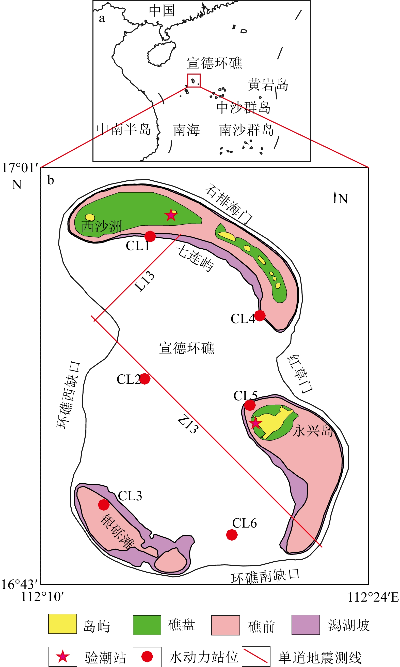
西沙群岛现今的岛礁碳酸盐台地是西沙台地大面积淹没以后的残留部分,宣德环礁就是其中的典型代表之一,其一直延续发育至今,完整地记录了西沙海域碳酸盐台地生物礁从旺盛到衰减的演化历史[26]。宣德环礁位于海南岛东南约180海里的海域(图1),环礁内发育七连屿及永兴岛礁盘。环礁发育4个深水口门,潟湖内水体交换以北部为主,发育沙波、槽沟、水下沙洲等多种特征地貌[25],环礁内沉积物以自生珊瑚碎屑和生物贝壳为主[27]。宣德海区为热带季风气候,盛行夏季偏南、冬季偏北的双向季风,潮汐为不规则日潮,潮流随季风变化,海浪以风浪为主[28]。
![]()
环礁潟湖的水动力条件是塑造区内地貌形态及演化发育的关键影响因素,受气候、季节周期化变化和地形等多种因素作用,水下沙洲等动力地貌处于动态变化中,目前对环礁内水动力缺乏实测数据,对环礁内动力地貌作用过程尚未有定性认识。本文通过单波束水下地形测量、海底表层沉积物取样、单道地震剖面探测和潮汐水文水动力实测等方法,开展环礁水动力现场观测、水文要素和水动力条件定量化分析,并对宣德环礁水下沙洲动力地貌开展综合调查,查明其物质组成和地貌形态,进而对其地貌类型进行划分,研究其在动力作用下的形成机制,并探讨宣德环礁古地形地貌的演变历史。
2. 数据和方法
2.1 数据采集概况
2015—2016年,海南省海洋地质调查研究院利用单波束测深、单道地震剖面测量、水文水动力测量及表层沉积物取样等多种现场调查手段,对宣德环礁开展了综合地质调查研究。测量采用WGS-84坐标系、UTM投影、GMT时间和三沙独立高程系。海上导航定位使用SF-3050接收机,亚米级精度,海底表层沉积物由蚌式取样器获取,由中科院海洋研究所进行表层沉积物粒度测试分析,粒度分级采用尤登-温德华氏等比制粒级标准,沉积物分类采用Folk&Ward分类法[29]。
2.2 单波束测深
单波束地形测量按1∶10000比例尺布设,采用南方SDE-28S单波束回声测深仪,工作频率200 kHz,测量误差优于水深的1%,水深数据经声速校正、潮汐校正、测线自动数据滤清和人工测线数据处理。
2.3 水文水动力
本次水文动力调查(位置见图1)包括CTD (Conductivity, Temperature, Depth)测量、潮位观测和海流观测,潮位观测使用RBR virtuoso duo T.D|tide潮位仪,海流观测使用美国RDI ADCP(300、600 k)声学多普勒流速剖面仪。验潮站位布设在永兴岛和赵述岛近岸,水位观测数据采样时间间隔为5 min,准确度优于25 cm。海流观测共6个站位,为舷挂式三船定点同测,分别于2016年的5月5日、8日两个周日进行连续25 h沉积动力实测,层位按1 m/层设置,盲区2 m,水体潮流分析分为3层:表层(2 m)、中层(0.6 h)和底层(h−2),h为站位水深。
2.4 单道地震
本次研究选用单道地震剖面Z13和L13(测线位置如图1所示)进行宣德环礁浅部地层特征及古环境地貌界线分析。其中Z13测线长24.8 km,NW-SE向;L13测线9.3 km,NE-WS向。单道地震测量设备采用Geo Marine Survey单道地震系统,GeoSpark-2000J震源、24单元液缆水听器,震源能量1 200/1 400 J,采样频率6 kHz,记录长度600 ms,采集软件选用GeoSuite Acquisition。单道地震数据经原始资料输入、道检查、极性检查延时校正、球面扩散补偿、振幅均衡、带通滤波、F-K变换、预测反褶积、时窗压制、空间变换和混波等流程处理。
3. 结果
3.1 潮汐特征
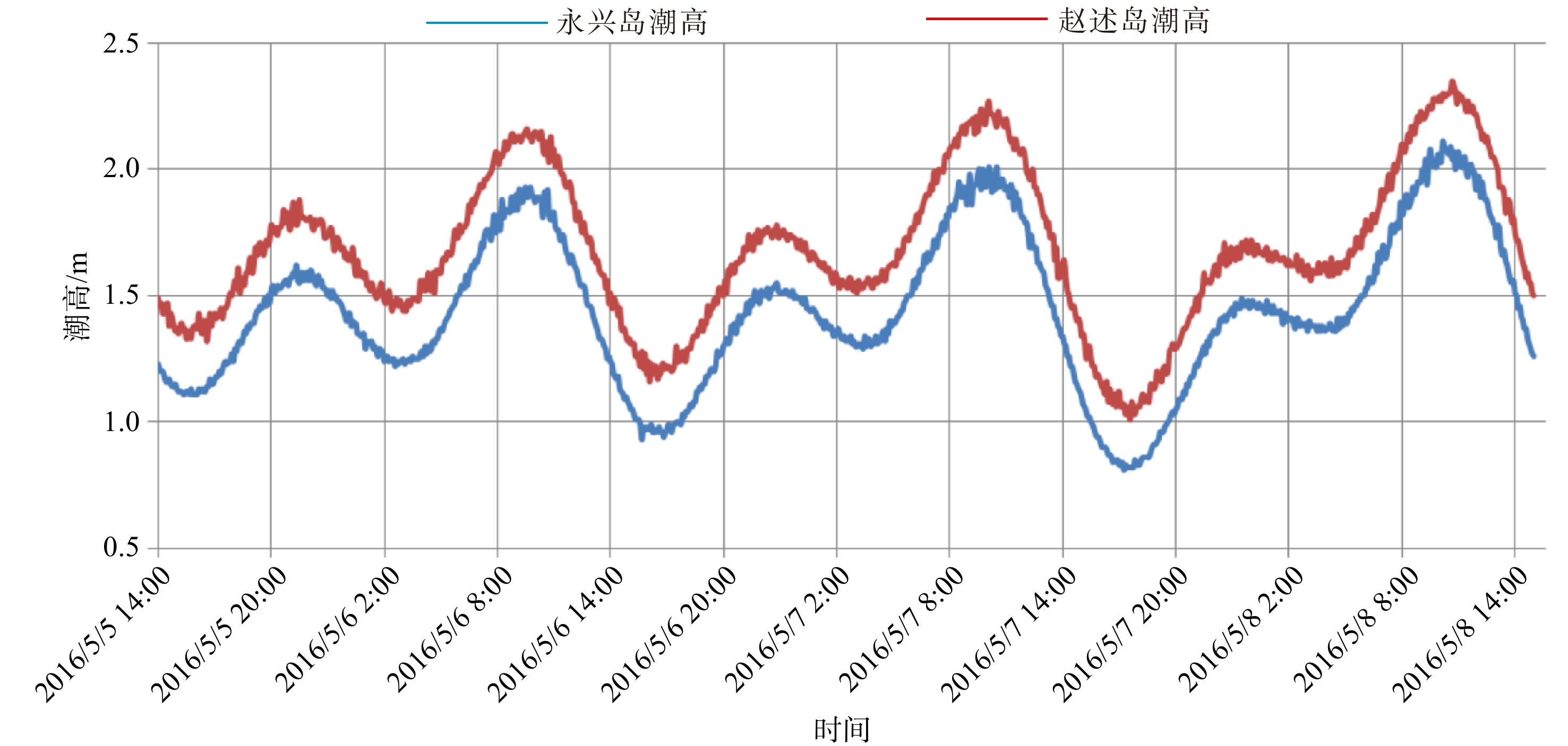
研究区为不规则全日潮,5月5—8日的实测潮位数据显示(图2),一个周日内,由两次高潮和两次低潮向一次高潮和一次低潮变化。以永兴站数据为例,5月5—6日的周日中,第一次涨落潮潮差分别为0.44和0.33 m,历时为6和5 h,第二次涨落潮潮差分别0.66和0.98 m,历时均为7 h;5月7—8日的潮日中,只有一次涨落潮,涨潮时存在一次平潮期。赵述岛潮位曲线平均高于永兴岛潮位曲线约0.24 m,应与两站位所处礁盘的影响有关,两个潮位曲线相位基本相同,涨潮平均约5~7 h,落潮历时约4~7 h,涨潮历时大于落潮历时。
![]() 图 2 调查期间永兴岛和赵述岛潮位变化Figure 2. Tidal level variations in the Yongxing Island and Zhaoshu Island during the investigation
图 2 调查期间永兴岛和赵述岛潮位变化Figure 2. Tidal level variations in the Yongxing Island and Zhaoshu Island during the investigation3.2 潮流特征
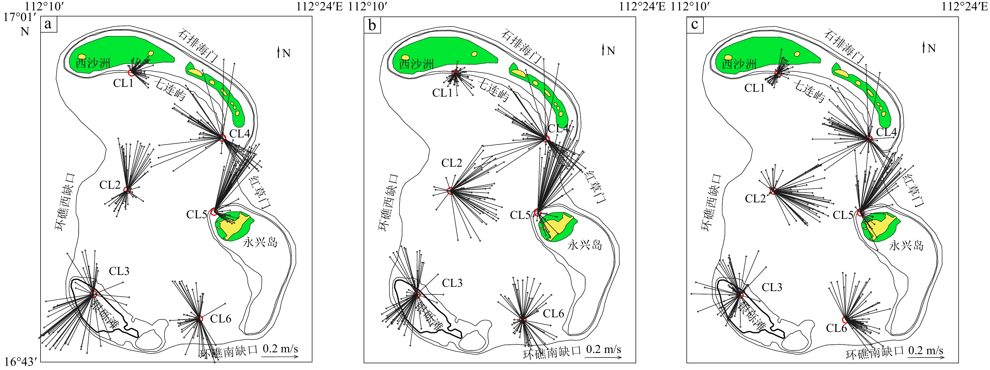
海流实测数据(表1)显示研究区涨落潮的动力强度差别不大,从同站位同层内实测数据来看,涨潮及落潮的流速极值和平均值没有较大差异;以平均流速分析,中层流速大于表层流速,底层流速最低,其差值在0.02~0.05 m/s。但值得注意的是各层最大流速差别不大,尤其是水深最深的底层流,其最大流速依然可以达到与表层和中层的最大流速相近数值。流向上,研究区潮流流向变化复杂,以平均流向分析,同点位涨落潮时,表、中、底各层之间的流向一致性差,显示出较杂乱特征(图3)。通过各站位水动力数据分析,底层平均流速与平均流向数据稳定性最佳,庄振业等[30]对陆架沙波的波流计算表明,扬子浅滩(水深40 m)处的水下沙波在常态天气下,浪流作用几乎可以忽略,起主导作用的为涨落潮流,尤其是近底100 cm的底层海流。因此,本文以底层水动力数据为依据(表2),分析近底水动力环境特征。
表 1 研究区6个调查站位实测涨落潮流最大流速、流向及平均流速、流向Table 1. The measurements of the maximum, average flow velocity, and flow direction of flood and ebb tides at six survey sites in the study area站号 水深/m 流速/(m/s) 流向/(°) 表层 中层 底层 表层 中层 底层 CL1 24 涨潮最大 0.13 0.16 0.14 33.2 308.8 80.3 落潮最大 0.12 0.08 0.14 330.8 241.8 50.5 涨潮平均 0.07 0.07 0.05 130.6 259.3 164 落潮平均 0.05 0.04 0.06 132 174.8 161.4 CL2 50 涨潮最大 0.35 0.38 0.42 55.5 28.8 348.7 落潮最大 0.32 0.36 0.39 98.8 92.4 327.7 涨潮平均 0.19 0.21 0.23 154.7 144.4 227.5 落潮平均 0.12 0.25 0.25 188.7 236.8 220.2 CL3 16 涨潮最大 0.46 0.31 0.4 222.7 108.1 195.4 落潮最大 0.39 0.31 0.29 239.7 262.6 155.8 涨潮平均 0.29 0.25 0.19 164 163.6 150.6 落潮平均 0.26 0.16 0.11 216.8 212.2 209.6 CL4 30 涨潮最大 0.44 0.46 0.47 229.7 218.9 216.3 落潮最大 0.48 0.48 0.49 209.3 206.6 91.8 涨潮平均 0.24 0.25 0.21 230.5 233.2 0.2 落潮平均 0.15 0.19 0.2 101.5 158.7 154.3 CL5 22 涨潮最大 0.49 0.6 0.47 70.5 69.3 60.4 落潮最大 0.56 0.51 0.44 57.9 78.3 53.9 涨潮平均 0.25 0.28 0.23 145.9 122.8 133.1 落潮平均 0.29 0.32 0.26 70.9 89.7 97.7 CL6 56 涨潮最大 0.3 0.27 0.3 127.1 94.5 91.7 落潮最大 0.26 0.29 0.31 295.4 83.1 300.5 涨潮平均 0.19 0.17 0.17 188.9 199.2 202.2 落潮平均 0.14 0.11 0.12 191.7 162.7 206.5 ![]() 图 3 研究区6个调查站位实测流速、流向图a: 表层, b: 中层, c: 底层。Figure 3. The flow velocity and direction of flood and ebb tides at six sites in the study areaa: Surface water, b: middle water, c: bottom water.表 2 研究区6个调查站位实测底层流参数Table 2. Parameters of bottom flows measured at six survey sites in the study area
图 3 研究区6个调查站位实测流速、流向图a: 表层, b: 中层, c: 底层。Figure 3. The flow velocity and direction of flood and ebb tides at six sites in the study areaa: Surface water, b: middle water, c: bottom water.表 2 研究区6个调查站位实测底层流参数Table 2. Parameters of bottom flows measured at six survey sites in the study area站号 最大流速/(m/s) 流向 平均流速/(m/s) 流向 CL1 0.14 E 0.06 SE CL2 0.42 NW 0.24 SW CL3 0.4 S 0.15 SE/S CL4 0.49 SW/E 0.21 N/SE CL5 0.47 NE 0.25 SE CL6 0.3 E/W 0.15 SW CL1测站位于七连屿广大弧形礁盘内侧,水深24 m,最大底层流速0.14 m/s,平均底层流速0.06 m/s,流向SE与礁盘地形弯曲变化方向一致,潮流由西沙洲深水口门进入潟湖后在七连屿形成E向为主的沿岸流。CL4测站位于七连屿南沙洲附近,水深30 m,最大底层流速0.49 m/s,平均底层流速0.21 m/s,最大流速及平均流速在涨落潮时,流向均不一致,显示其所处区域水动力环境复杂,以平均流速分析,涨落潮动力强度相近,流向呈现近N-S向往复流,表明七连屿E向沿岸流由环礁西北的西沙洲口门运动至南沙洲后受“红草门”潮流作用而产生转向。CL5测站位于永兴岛礁盘,水深22 m,流速与CL4测站大小一致,流向SE向,是“红草门”进入潟湖潮流在永兴受礁盘形成的沿岸流向。环礁西侧CL2测站水深50 m,最大底层流速0.42 m/s,平均底层流速0.24 m/s,最大流速流向NW,平均流速流向SW,总体表现为W向底层水流运动特征。CL3测站位于银砾滩,水深16 m,最大底层流速0.40 m/s,平均底层流速0.15 m/s,差异较大,流向以S向为主。CL6测站位于环礁南侧潟湖区,水深56 m,最大底层流速0.30 m/s,平均底层流速0.15 m/s,平均流向SW。CL2、CL4、CL5的底层平均流速为0.24 m/s,与其余站点有明显区别,代表着研究区潟湖口门处底层强水动力环境;CL1、CL3站主要受到礁盘及浅滩影响,CL6站点显示出潟湖南部相对封闭的弱水动力环境。
3.3 水下沙洲动力地貌特征
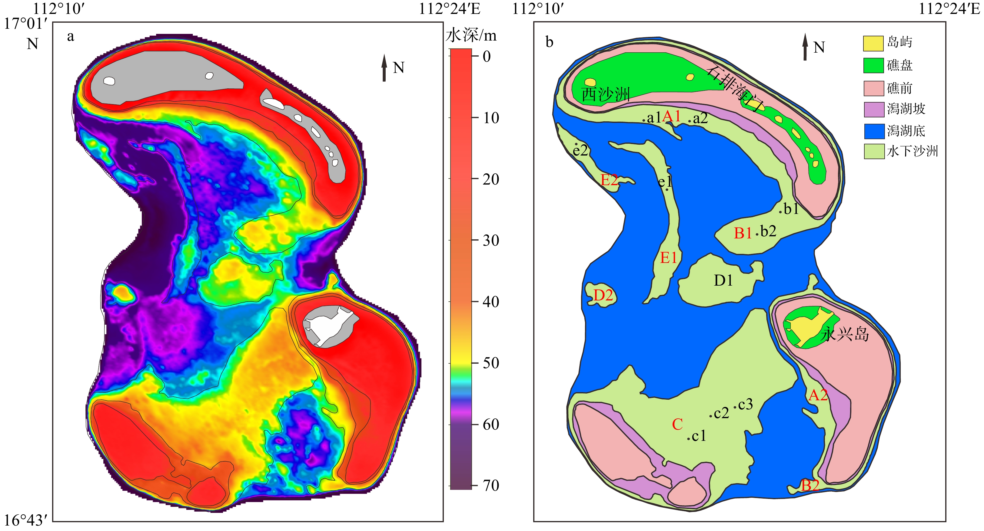
笔者前期根据研究区侧扫声纳探测的微地貌特征,结合沉积物测试、水深地形数据,在研究区划分出3级11类水下地貌单元,编制了宣德环礁水下地貌类型图,提出了宣德环礁潟湖砂质沉积地貌受潮流动力作用控制,以及地貌界限与海底等深线吻合较好的认识,同时对研究区水下沙洲地貌进行了初步研究并圈定了其主要范围[25]。本文在该研究基础上,以水下沙洲地貌为研究主体,依据实测水深数据,细化50~55 m水深的色阶划分,并生成水深渲染图(图4a)。结果表明,研究区潟湖坡水深为20~45 m,水下沙洲发育水深为45~55 m,其中45~50 m水深区间(图4a中黄绿色区域)边缘形态破碎锐利,显示其动态变化的特征,50~55 m水深范围内沙洲边缘形态则较平滑完整。沉积动力是砂质堆积地貌的主要影响因素,参考海岸动力地貌学砂质沉积地貌分类[31-32],根据形态特征将宣德环礁水下沙洲分为A1—E2共5类9个水下沙洲,绘制出宣德环礁水下沙洲类型分布图(图4b)。沙洲基本参数见表3,表层沉积物站位(图4b中a1、a2)的粒度参数见表4。
![]() 图 4 研究区水深渲染图(a)及水下沙洲类型分布图(b)Figure 4. Bathymetry map of the study area (a) and the distribution of different types of submarine sandbanks in the study area(b)表 3 研究区水下沙洲参数Table 3. Parameters of submarine sandbanks in the study area
图 4 研究区水深渲染图(a)及水下沙洲类型分布图(b)Figure 4. Bathymetry map of the study area (a) and the distribution of different types of submarine sandbanks in the study area(b)表 3 研究区水下沙洲参数Table 3. Parameters of submarine sandbanks in the study area水下沙洲 长/km 宽/km 水深/m 走向 A1 17 1 45~50 NW-SE A2 12.1 0.8 45~50 NW-SE B1 5.4 2 45~50 NE-SW B2 1.9 0.9 45~50 W-E C 10.3 4.8 43~53 NE-SW D1 4.7 3.1 45~55 W-E D2 1.6 1.1 45~55 W-E E1 11.5 1.3 50~55 NW-SE E2 5.4 0.9 50~55 NW-SE 表 4 表层沉积物粒度参数Table 4. Parameters of submarine surface sediments in the study area站号 水深/m 平均粒径/ϕ 分选系数 偏态 峰态 a1 52 2.96 2.38 0.12 1.5 a2 50 3.14 1.37 0.33 1.39 b1 49 3.13 2.25 0.42 1.43 b2 50 0.42 2.28 0.64 0.92 c1 44 0.15 1.54 0.55 0.64 c2 48 1.13 1.61 -0.37 1.2 c3 46 0.96 2.16 0 0.88 e1 55 1.1 1.54 -0.31 0.69 e2 51 1.43 3.5 0.91 0.85 3.3.1 沿岸型
沿岸型水下沙洲出现在七连屿(图4b中A1)和永兴岛(图4b中A2),沿广大弧形礁盘的潟湖坡发育,形态狭长弯曲,受礁盘控制明显,发育水深45~50 m,最大水深53 m,长宽比约17~15。其中七连屿A1砂体沉积物(图4b中a1、a2)的平均粒径ϕ值分别为2.96、3.14,粒径由西沙洲向红草门方向减小,分选系数降低,表明其受礁盘E向沿岸流水动力作用的影响。
3.3.2 沙嘴型
海岸动力地貌中,沙嘴是海岸泥沙流在陆地突出部位形成的堆积体[31]。当海岸泥沙流绕过岬角时,波浪能量降低,被搬运的泥沙开始沉积,形成沙嘴。沙嘴形成的方向与泥沙流的方向一致,但与泥沙流方向不同的水流也可以导致沙嘴弯曲。研究区水下沙嘴位于七连屿-永兴岛深水口门“红草门”(图4b中B1)及宣德环礁南部缺口处(图4b中B2),其发育与沿岸型沙洲紧密相连,是沿岸沙洲口门处的沿岸流与口门入潟湖的潮流相互作用而沉积形成的,发育水深45~50 m,长宽比约2.7~2。B1砂体沉积物(图4b中b1、b2)的平均粒径ϕ值分别为3.13、0.42,水深、分选系数均相同,表明“红草门”口门中部水动力强度远大于近岸。
3.3.3 潮流沙脊型
潮流沙脊是潮流在海底塑造的堆积地貌,延伸方向与潮流方向平行,发育于河口、海峡及风暴频繁的浅海环境。潮流沙脊的发育受多种因素作用影响,主要为水深变化、物源供给及沉积动力(主要为潮流)。沉积动力塑造沙脊的线状外形,水深变化决定其发育和终止时间,物源是其发育的基础[31]。研究区西沙洲深水口门处(图4b中E2)、口门至潟湖中心(图4b中E1)发育有潮流沙脊状水下沙洲,发育水深50~55 m,长宽比约8.8~6。沉积物(图4b中e1、e2)的平均粒径变化不大,粒径ϕ值分别为1.1、1.4,表明其水动力作用强劲,而e2处的高分选系数表明,西沙洲深水口门处动力比潟湖内更强,水动力环境出现较大变化。高抒等[33]指出,潮流沙脊形成的流速条件为0.7~1.3 m/s,脊线几乎平行于潮流流向。研究区实测站位最大流速为0.49 m/s,潮流强度不足以塑造E1如此规模的水下沙洲。笔者曾依据侧扫地貌图像[25]发现,该区域主要由砂质沉积物沉积和填充在珊瑚礁格架中。E1的侧扫图像(图5b)展现了清晰的珊瑚礁体形态,表明潮流沙脊是在原珊瑚礁基础上发育的。同区域中潟湖60 m水深处(图5b中A区)发育珊瑚点礁群,其侧扫影像(图5a)及水深剖面(图5c)显示,礁体与其他海底沉积物无显著高差,93 m剖面长度的高差仅为0.15 m,同时有沙波结构发育并贯穿在礁体及其他沉积物中,表明其为埋藏型礁体。胡新迪等[34]通过浅层地震剖面数据分析,在南沙道明群礁潟湖基底内相对水深60~65 m处也发现存在埋藏点礁,该点礁发育于地质历史时期的低海平面环境,后期由于海平面快速上升,珊瑚礁生长速度追不上海平面上升速度而停止发育,继而被埋藏。
![]()
以上证据表明,E1在低海平面时期显著发育,海平面上升后则停止发育并形成礁体格架,砂质沉积物经海流搬运后填充沉积在礁体格架中,因而地貌上继承了原珊瑚礁的形态特征。
3.3.4 连岛型
海岸动力地貌中,将相邻岛屿连接起来的泥沙堆积体称为连岛沙洲。岛后形成波影区,波、流能量降低,泥沙流容纳量降低,在波影区形成沉积,先形成三角形沙嘴,后形成连岛沙洲。连岛沙洲的形成与岛屿长度L和岛屿与陆地距离J密切相关。J/L<1.5时,形成连岛沙坝;J/L>3.5时,岛屿对海岸无明显影响;1.5<J/L<3.5时,岛后波影区形成三角岬、突出岸和海角[31]。研究区银砾滩及永兴岛礁盘间发育连岛型水下沙洲(图4b中C),发育水深43~53 m,沉积物(图4b中c1—c3)的平均粒径ϕ值分别为0.15、1.13、0.96,指示出水动力强度c1远大于c2、c3。c1—c3分布在沿银砾滩展布的方向上(图4b),c2粒径数值最小,表明永兴岛向银砾滩方向输运了物质。以银砾滩为岛,永兴礁盘为岸,取水深20 m处礁前区为测量起止边界,银砾滩长约9.89 km,距永兴礁盘11.30 km,J/L为1.14,该数值符合连岛沙坝形成条件。但应考虑到海岸沙洲形成动力以浪控为主,水深十余米以内,而研究区连岛沙洲水深四十余米,动力以底层潮流为主,且实测水动力强度较弱。故推测其发育过程可能与潮流珊瑚沙洲相似,即低海平面时浅水浪控环境下发育,形成连岛基础,海平面上升后,受现代潮流动力输运沉积物的沉积影响,因此,该连岛沙洲在早期的发育和现今格局形成,都很可能受永兴-银砾滩相互作用影响。
3.3.5 中心型
以潟湖中心区域发育的D1砂体为代表,发育水深45~55 m,平面形态近圆形,长宽比约1.5。发育水深较深及近圆形的平面形态,显示出其所处的潟湖中心区的水动力强度应较弱。
3.4 单道地震剖面特征
本文结合水深、侧扫和单道地震解译数据,绘制了宣德环礁水下沙洲综合解释图(图6)。对测线L13、Z13单道地震剖面的实测数据,基于地震反射同相轴特征分析了地震相反射结构、几何关系、波阻特征和反射界面特征。在潟湖区域中识别了T0—T2共3个地震反射界面,4个珊瑚礁体地震相(图6c、图6d)。T0是海底反射面,表现为强振幅、高能量和高连续性,其起伏形态主要反映海底地形的变化。T1表现为强振幅、高频率、连续性好,其上地层内部表现为空白反射,相对水深约50~71 m,潟湖内平均相对水深65 m,T0—T1沉积厚度在潟湖底内约为3 m,在礁滩体处为5~7 m,整个研究区内的平均厚度为5 m。T2为一套中—强振幅、中等频率、连续性较差的反射界面,其上地层内部表现为近平行的反射结构,其下地层内部多呈杂乱反射,相对水深约60~80 m,潟湖内平均相对水深为70 m。
![]() 图 6 研究区水下沙洲综合解释图a: 测线L13、Z13路线示意图,b: 测线L13侧扫及水深渲染图,c: 单道地震相解译图,d: 测线L13、Z13单道地震剖面解释图。Figure 6. Comprehensive interpretation of submarine sandbanks in the study areaa: Survey lines L13 and Z13, b: side scan images and bathymetry of line L13, c: interpretation of seismic facies, d: interpretation map of seismic facies in L13 and Z13.
图 6 研究区水下沙洲综合解释图a: 测线L13、Z13路线示意图,b: 测线L13侧扫及水深渲染图,c: 单道地震相解译图,d: 测线L13、Z13单道地震剖面解释图。Figure 6. Comprehensive interpretation of submarine sandbanks in the study areaa: Survey lines L13 and Z13, b: side scan images and bathymetry of line L13, c: interpretation of seismic facies, d: interpretation map of seismic facies in L13 and Z13.地震相1为低位礁,顶部尖挺,内部杂乱或空白反射,主要分布于环礁向海坡,通常为向海坡阶地地貌,测线L13、Z13低位礁体发育水深约80 m。地震相2为边缘礁,呈丘状但顶部较平整,内部为杂乱或空白反射,主要分布在台地边缘。地震相3为塔礁,丘状,顶部像塔尖,发育于潟湖内。地震相4为礁滩体,丘状且顶部起伏较大,内部为杂乱或空白反射,主要分布在潟湖区域。
4. 讨论
4.1 早全新世宣德环礁潟湖地貌
赵焕庭[35]研究认为南海诸岛自晚渐新世长期呈下降趋势,但沉降速率很小;詹文欢等[36]、冯英辞等[37]分别通过珊瑚礁信息和西沙单道地震剖面,发现西沙群岛在更新世后构造稳定,因此,气候变化造成的海平面升降是控制西沙环礁发育的主要因素。
研究区内水下沙洲E1、E2、A1和水下沙洲C(图6d)发育晚于水深80 m左右的低位礁体,应始于T1界面,相对水深约64 m。结合宣德环礁60 m水深处发育的埋藏珊瑚礁地貌(图6a、图6b),其发育时代应与珠江口水深50~60 m处的水下阶地、南海北部水深50 m处的古潟湖、永暑岛东南坡水深50 m处的水下阶地等地貌相似,为早全新世(距今12~11 ka)低海平面(低于现今海平面50~60 m)时形成[38-40]。
地震剖面中,水下沙洲表现为碳酸盐岩丘状体,反射特征显示其为礁滩体,为全新世早期的生物礁在潟湖浅水环境生长以及生物碎屑在原地堆积形成。同时发育了碳酸盐岩台地边缘平顶的早期边缘礁(图6d),后期海平面快速上升,边缘礁体被淹没并停止发育。据前期的研究结果显示,这种海平面快速上升的过程在南海是区域性的,至9 ka时海平面(–20 m)淹没了美济环礁暴露面,8 ka珊瑚礁开始全面发育[41-42]。基于数值模型开展的末次冰期以来南海西北部古海岸线的重建结果也表现了这一过程[43]。
张宝民等[44]在礁滩体与建设性成岩作用研究中指出,礁、礁丘、丘和滩的发育及沉积与当时的古地理背景、古地貌位置、古水深和古水动力条件密切相关。生物礁发育于海域各种古地貌的中等—高能环境,以台地边缘最为常见。滩广泛发育于开阔台地(粒屑滩)和台地边缘(浅滩)等的中等—高能环境,平坦的沉积地形和浅水潮汐、波浪、风暴作用是必备条件。据此,可以通过研究区的礁滩体和反射界面特征重建早全新世时期宣德环礁古潟湖地貌形态。T1界面在七连屿礁盘边坡可追索至相对水深约48 m处,可指示出当时海平面高度和礁坪沙洲地貌单元发育边界。礁滩体发育于浅水环境中,受波浪、潮流作用,其指示的古环境地貌单元为礁盘,T1界面上,礁滩体发育相对水深约56~64 m,平均相对水深60 m,考虑到研究区自T1平均沉积厚度约5 m,早全新世时礁盘地貌单元边界在环礁现代地形中的界线应为现今水深55 m,则早全新世时研究区礁盘区水深为50~55 m,古水深约5 m,礁坪和砂岛发育边界水深为50 m。
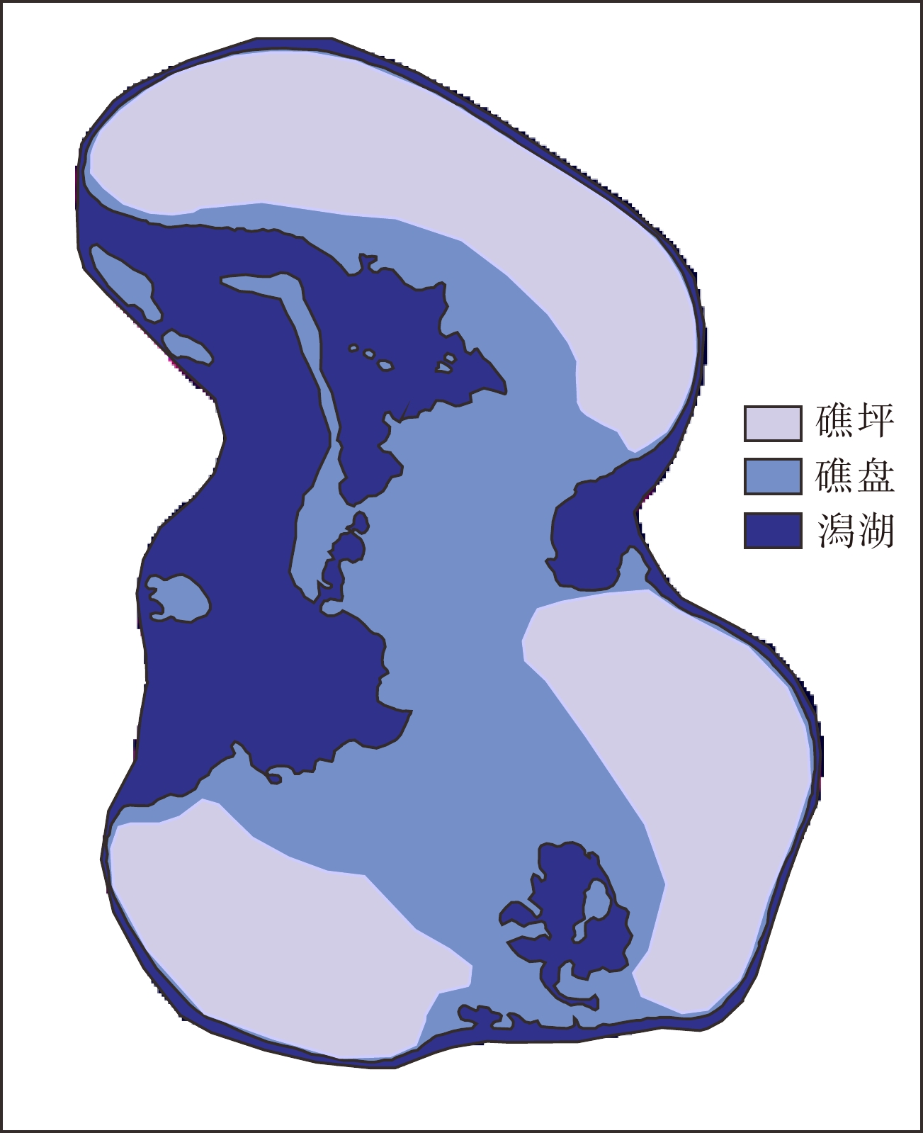
据由上述礁盘、礁坪和潟湖发育范围生成的宣德环礁早全新世古地貌图(图7)可见,宣德环礁呈半开放状态,环礁内发育次生潟湖,地形西低东高,西侧为主要开放端,西北端的西沙洲是主要口门,环礁西侧缺口为另一口门,东侧由七连屿、永兴至环礁南端发育广大礁坪,很可能就是现今银砾滩-永兴礁盘之间水下连岛沙洲发育的基础。地貌显示,由西沙洲口门处进入潟湖的涨落流体在早全新世也仍然是潟湖地貌的主要塑造水体,口门处珊瑚礁走向为NW-SE向,指示了当时的涨落潮流方向。
![]() 图 7 宣德环礁早全新世地貌模拟图Figure 7. The simulated geomorphic map of Xuande Atoll in the Early Holocene
图 7 宣德环礁早全新世地貌模拟图Figure 7. The simulated geomorphic map of Xuande Atoll in the Early Holocene4.2 宣德环礁水下沙洲动力地貌成因机制
吴自银等[45]研究认为气候、海平面、风暴、潮流、水深、地形、岸线等因素在沙脊的形成过程中共同构成相互关联的响应系统,并提出全球性气候变化形成的海平面升降是沙脊地貌形成的根本因素,合适的沉积动力是发育的直接原因,物源供给、水深变化、海底地形是影响海底沙脊发育过程及沙脊类型的重要因素。
在沉积动力方面,沉积物供给充足、大潮流速达到0.6~1 m/s是海底沙丘形成的基本条件 [33],而潮流沙脊形成流速条件为0.7~1.3 m/s,高度可达20 m以上。Simons 等[46]发现流速为0.26~1.3 m/s的缓紊流是发育沙波的主要动力。庄振业等[47]对国内外19片水下沙丘进行了统计分析,发现陆架底流速为0.4~0.8 m/s时沙丘发育最好。
宣德环礁潟湖地貌发育的阶段性结果表明,研究区水下沙洲发育主要是受气候变化引起的海平面升降作用控制,在低海平面时期礁体显著发育,海平面快速上升导致珊瑚礁停止发育而形成礁体格架。研究区水动力实测数据显示,表、中、底最大流速均可达到0.4 m/s,底层平均流速0.15~0.2 m/s,最大流速可以达到陆架沙丘良好发育条件,但无法满足大型潮流沙脊发育流速条件。此外,区内底层平均流速低于0.26~1.3 m/s的缓紊流限值,研究区水下沙洲发育规模以5、10 km为主(表3),现今水动力条件不适于单独建造研究区水下沙洲形态,但在继承原珊瑚礁格架形态的基础上,涨落潮流足以通过运输砂质沉积物并填充沉积来塑造出现今水下沙洲地貌。因此,水下沙洲发育的主要影响因素为海平面升降>地形基础(珊瑚礁格架、礁盘岸线、口门)>涨落潮流。
基于以上认识,本研究提出水下沙洲的发育演化过程为:末次冰期后海平面开始上升,在早全新世(12~11 ka)上升至–50~60 m处停滞,海平面的停滞造成珊瑚礁侧向生长,塑造了环礁潟湖内水深50~55 m区间的礁体格架、银砾滩和永兴礁盘间的连岛基础及水深60 m处的埋藏珊瑚礁。随后海平面快速上升,珊瑚礁停止发育并形成了现代水深60~70 m处潟湖底与深水口门的格局。
海平面停滞上升后,现代潮流由深水口门进入潟湖,遇广大礁盘形成沿岸流并依其地形走势而变向,“西沙洲”口门在七连屿形成E向为主的沿岸流,由西向东输运砂质沉积物,“红草门”潮流在永兴礁盘形成SE向沿岸流,并在礁盘区塑造沿岸型沙洲。沿岸流运移至口门处,遇方向不同的水流互相影响,形成沙嘴状沉积,使得研究区沿岸型沙洲在口门处伴生沙嘴状沙洲,七连屿沿岸流在南沙洲处与“红草门”水体发生顶推,形成NE-SW走向沙嘴,永兴礁盘沿岸流在潟湖南端口门处,形成W-E向沙嘴。在潟湖内部,由于不同方向流体相互作用及地形影响,形成了多因素作用的复杂机制,银砾滩及永兴礁盘间发育连岛型水下沙洲;表层沉积物粒径分析表明,银砾滩和永兴礁盘均向其间的连岛沙洲输运了砂质沉积物,“红草门”、潟湖西侧及南侧口门水体均对其产生作用。该连岛沙洲在早期发育和后期格局形成过程中,都很可能一直受永兴-银砾滩相互作用影响。潟湖中部水动力强度弱,较深的发育水深及接近中和的水动力作用,使其发育了平面形态为近圆形的中心型水下沙洲。
5. 结论
(1)宣德环礁潟湖内水深50~55及60 m发育的礁滩体和埋藏珊瑚礁,是全新世50~60 m低海平面时发育的地貌,海平面停滞造成珊瑚礁侧向生长,形成现代60~70 m深潟湖与深水口门的格局。研究区50~55 m水深发育的地貌边界很可能保留了早全新世时期古潟湖礁盘地貌轮廓形态。
(2)宣德环礁潟湖发育5类动力地貌特征形态的水下沙洲:沿岸型、沙嘴型、潮流沙脊型、连岛型、中心型。宣德环礁表、中、底最大流速均可到达0.4 m/s,底层平均流速0.15~0.2 m/s,环礁底层涨落潮流是塑造水下沙洲主要现代动力因素。
(3)涨落潮流运输砂质沉积物在海平面升降后形成的地形基础上沉积,塑造了现今水下沙洲地貌。水下沙洲发育的主要影响因素强弱次序为海平面升降、地形基础(珊瑚礁格架、礁盘岸线、口门)和涨落潮流。
致谢:感谢海南省海洋地质调查研究院陈飞高级工程师,中国科学院深海科学与工程研究所张汉羽、陈万利博士在地震解译方面给予的大力支持!
-
![]()
![]()
图 2 调查期间永兴岛和赵述岛潮位变化
Figure 2. Tidal level variations in the Yongxing Island and Zhaoshu Island during the investigation
![]()
图 3 研究区6个调查站位实测流速、流向图
a: 表层, b: 中层, c: 底层。
Figure 3. The flow velocity and direction of flood and ebb tides at six sites in the study area
a: Surface water, b: middle water, c: bottom water.
![]()
图 4 研究区水深渲染图(a)及水下沙洲类型分布图(b)
Figure 4. Bathymetry map of the study area (a) and the distribution of different types of submarine sandbanks in the study area(b)
![]()
![]()
图 6 研究区水下沙洲综合解释图
a: 测线L13、Z13路线示意图,b: 测线L13侧扫及水深渲染图,c: 单道地震相解译图,d: 测线L13、Z13单道地震剖面解释图。
Figure 6. Comprehensive interpretation of submarine sandbanks in the study area
a: Survey lines L13 and Z13, b: side scan images and bathymetry of line L13, c: interpretation of seismic facies, d: interpretation map of seismic facies in L13 and Z13.
![]()
图 7 宣德环礁早全新世地貌模拟图
Figure 7. The simulated geomorphic map of Xuande Atoll in the Early Holocene
表 1 研究区6个调查站位实测涨落潮流最大流速、流向及平均流速、流向
Table 1 The measurements of the maximum, average flow velocity, and flow direction of flood and ebb tides at six survey sites in the study area
站号 水深/m 流速/(m/s) 流向/(°) 表层 中层 底层 表层 中层 底层 CL1 24 涨潮最大 0.13 0.16 0.14 33.2 308.8 80.3 落潮最大 0.12 0.08 0.14 330.8 241.8 50.5 涨潮平均 0.07 0.07 0.05 130.6 259.3 164 落潮平均 0.05 0.04 0.06 132 174.8 161.4 CL2 50 涨潮最大 0.35 0.38 0.42 55.5 28.8 348.7 落潮最大 0.32 0.36 0.39 98.8 92.4 327.7 涨潮平均 0.19 0.21 0.23 154.7 144.4 227.5 落潮平均 0.12 0.25 0.25 188.7 236.8 220.2 CL3 16 涨潮最大 0.46 0.31 0.4 222.7 108.1 195.4 落潮最大 0.39 0.31 0.29 239.7 262.6 155.8 涨潮平均 0.29 0.25 0.19 164 163.6 150.6 落潮平均 0.26 0.16 0.11 216.8 212.2 209.6 CL4 30 涨潮最大 0.44 0.46 0.47 229.7 218.9 216.3 落潮最大 0.48 0.48 0.49 209.3 206.6 91.8 涨潮平均 0.24 0.25 0.21 230.5 233.2 0.2 落潮平均 0.15 0.19 0.2 101.5 158.7 154.3 CL5 22 涨潮最大 0.49 0.6 0.47 70.5 69.3 60.4 落潮最大 0.56 0.51 0.44 57.9 78.3 53.9 涨潮平均 0.25 0.28 0.23 145.9 122.8 133.1 落潮平均 0.29 0.32 0.26 70.9 89.7 97.7 CL6 56 涨潮最大 0.3 0.27 0.3 127.1 94.5 91.7 落潮最大 0.26 0.29 0.31 295.4 83.1 300.5 涨潮平均 0.19 0.17 0.17 188.9 199.2 202.2 落潮平均 0.14 0.11 0.12 191.7 162.7 206.5  下载: 导出CSV
表 2 研究区6个调查站位实测底层流参数
Table 2 Parameters of bottom flows measured at six survey sites in the study area
站号 最大流速/(m/s) 流向 平均流速/(m/s) 流向 CL1 0.14 E 0.06 SE CL2 0.42 NW 0.24 SW CL3 0.4 S 0.15 SE/S CL4 0.49 SW/E 0.21 N/SE CL5 0.47 NE 0.25 SE CL6 0.3 E/W 0.15 SW
下载: 导出CSV
表 3 研究区水下沙洲参数
Table 3 Parameters of submarine sandbanks in the study area
水下沙洲 长/km 宽/km 水深/m 走向 A1 17 1 45~50 NW-SE A2 12.1 0.8 45~50 NW-SE B1 5.4 2 45~50 NE-SW B2 1.9 0.9 45~50 W-E C 10.3 4.8 43~53 NE-SW D1 4.7 3.1 45~55 W-E D2 1.6 1.1 45~55 W-E E1 11.5 1.3 50~55 NW-SE E2 5.4 0.9 50~55 NW-SE
下载: 导出CSV
表 4 表层沉积物粒度参数
Table 4 Parameters of submarine surface sediments in the study area
站号 水深/m 平均粒径/ϕ 分选系数 偏态 峰态 a1 52 2.96 2.38 0.12 1.5 a2 50 3.14 1.37 0.33 1.39 b1 49 3.13 2.25 0.42 1.43 b2 50 0.42 2.28 0.64 0.92 c1 44 0.15 1.54 0.55 0.64 c2 48 1.13 1.61 -0.37 1.2 c3 46 0.96 2.16 0 0.88 e1 55 1.1 1.54 -0.31 0.69 e2 51 1.43 3.5 0.91 0.85
下载: 导出CSV
-
[1] 郑勇玲, 吴承强, 蔡锋, 等. 我国海底地貌研究进展及其在东海近海的新发现、新认识[J]. 地球科学进展, 2012, 27(9):1026-1034 ZHENG Yongling, WU Chengqiang, CAI Feng, et al. The present research trend of China’s submarine geomorphology and new discovery of the East China Sea offshore [J]. Advances in Earth Science, 2012, 27(9): 1026-1034.
[2] 周成虎. 地貌学辞典[M]. 北京: 中国水利水电出版社, 2006. ZHOU Chenghu. A Dictionary of Geomorphology[M]. Beijing: China Water & Power Press, 2006.
[3] 刘希林, 谭永贵. 现代地貌学基本思想的认识和发展[J]. 中山大学学报:自然科学版, 2012, 51(4):112-118 LIU Xilin, TAN Yonggui. Recognition and development of basic ideas of modern geomorphology [J]. Acta Scientiarum Naturalium Universitatis Sunyatseni, 2012, 51(4): 112-118.
[4] 程维明, 周成虎, 申元村, 等. 中国近40年来地貌学研究的回顾与展望[J]. 地理学报, 2017, 72(5):755-775 doi: 10.11821/dlxb201705001 CHENG Weiming, ZHOU Chenghu, SHEN Yuancun, et al. Retrospect and perspective of geomorphology researches in China over the past 40 years [J]. Acta Geographica Sinica, 2017, 72(5): 755-775. doi: 10.11821/dlxb201705001
[5] 余克服. 珊瑚礁科学概论[M]. 北京: 科学出版社, 2018. YU Kefu. Introduction to the Science of Coral Reefs[M]. Beijing: Science Press, 2018.
[6] Davis R A. Coastal Sedimentary Environments[M]. New York: Springer, 1978.
[7] Kennett J P. Marine Geology[M]. New York: Prentice-Hall, 1981: 76-371.
[8] Ren P, Bornhold B D, Prior D B. Seafloor morphology and sedimentary processes, Knight Inlet, British Columbia [J]. Sedimentary Geology, 1996, 103(3-4): 201-228. doi: 10.1016/0037-0738(95)00090-9
[9] Shaw J, Courtney R C. Multibeam bathymetry of glaciated terrain off southwest Newfoundland [J]. Marine Geology, 1997, 143(1-4): 125-135. doi: 10.1016/S0025-3227(97)00093-5
[10] Gardner J V, Dartnell P, Mayer L A, et al. Geomorphology, acoustic backscatter, and processes in Santa Monica Bay from multibeam mapping [J]. Marine Environmental Research, 2003, 56(1-2): 15-46. doi: 10.1016/S0141-1136(02)00323-9
[11] 陈俊仁. 我国南部西沙群岛地区第四纪地质初步探讨[J]. 地质科学, 1978(1):45-56 CHEN Junren. A preliminary discussion on quaternary geology of Xisha Qundao Islands of South China [J]. Chinese Journal of Geology, 1978(1): 45-56.
[12] 曾昭璇. 试论中国珊瑚礁地貌类型[J]. 热带地貌资料, 1980:1-16 ZENG Zhaoxuan. The geomorphological types of coral reef of China [J]. Tropical Landforms, 1980: 1-16.
[13] 曾昭璇, 黄少敏, 曾迪鸣. 西沙群岛石岛地貌学上诸问题[J]. 石油与天然气地质, 1984, 5(4):335-341 doi: 10.11743/ogg19840404 ZENG Zhaoxuan, HUANG Shaomin, ZENG Diming. Some problems concerning geomorphology of Shidao, Xisha Islands [J]. Oil & Gas Geology, 1984, 5(4): 335-341. doi: 10.11743/ogg19840404
[14] 余克服, 宋朝景, 赵焕庭. 西沙群岛永兴岛地貌与现代沉积特征[J]. 热带海洋, 1995, 14(2):24-31 YU Kefu, SONG Chaojing, ZHAO Huanting. The characters of geomorphology and modern sediments of Yongxing Island, Xisha Islands [J]. Tropic Oceanology, 1995, 14(2): 24-31.
[15] 孙宗勋, 赵焕庭. 南沙群岛珊瑚礁动力地貌特征[J]. 热带海洋, 1996, 15(2):53-60 SUN Zongxun, ZHAO Huanting. Features of dynamic geomorphology of coral reefs in Nansha Islands [J]. Tropic Oceanology, 1996, 15(2): 53-60.
[16] 王雪木, 陈万利, 薛玉龙, 等. 西沙群岛宣德环礁晚第四纪灰砂岛沉积地层[J]. 海洋地质与第四纪地质, 2018, 38(6):37-45 doi: 10.16562/j.cnki.0256-1492.2018.06.004 WANG Xuemu, CHEN Wanli, XUE Yulong, et al. The late quaternary carbonate sand deposits at the Xuande atoll [J]. Marine Geology & Quaternary Geology, 2018, 38(6): 37-45. doi: 10.16562/j.cnki.0256-1492.2018.06.004
[17] 王宇喆, 邱隆伟, 许红, 等. 七连屿海滩沙-沿岸沙丘-现代植物-砂岛成因模式[J]. 海洋地质前沿, 2021, 37(6):92-100 doi: 10.16028/j.1009-2722.2020.208 WANG Yuzhe, QIU Longwei, XU Hong, et al. Beach sand-coastal dunes-modern vegetation-sand island genetic model of the Qilianyu Island [J]. Marine Geology Frontiers, 2021, 37(6): 92-100. doi: 10.16028/j.1009-2722.2020.208
[18] 周胜男, 施祺, 周桂盈, 等. 南沙群岛珊瑚礁砾洲地貌特征[J]. 海洋科学, 2019, 43(6):48-59 doi: 10.11759/hykx20180822001 ZHOU Shengnan, SHI Qi, ZHOU Guiying, et al. Geomorphic features of coral shingle cays in the Nansha Islands [J]. Marine Sciences, 2019, 43(6): 48-59. doi: 10.11759/hykx20180822001
[19] 许眸莹, 高抒, 葛晨东, 等. 南海九章环礁中牛轭礁和西门礁新生沙洲沉积特征与动态[J]. 热带海洋学报, 2020, 39(2):44-53 XU Mouying, GAO Shu, GE Chendong, et al. Characteristics and morphodynamics of newly-formed coral debris deposits on the Niu’e and Ximen Reefs, Jiuzhang Atoll, South China Sea [J]. Journal of Tropical Oceanography, 2020, 39(2): 44-53.
[20] 郑金海, 时健, 陈松贵. 珊瑚岛礁海岸多尺度波流运动特性研究新进展[J]. 热带海洋学报, 2021, 40(3):44-56 doi: 10.11978/YG2020013 ZHENG Jinhai, SHI Jian, CHEN Songgui. Recent research advances on multi-scale coastal wave and current characteristics of coral reefs and islands [J]. Journal of Tropical Oceanography, 2021, 40(3): 44-56. doi: 10.11978/YG2020013
[21] 邵超, 戚洪帅, 蔡锋, 等. 海滩–珊瑚礁系统风暴响应特征研究: 以1409号台风“威马逊”对清澜港海岸影响为例[J]. 海洋学报, 2016, 38(2):121-130 SHAO Chao, QI Hongshuai, CAI Feng, et al. Study on storm-effects on beach-coral reef system: Taking the response of Qinglangang Coast on No. 1409 Typhoon Rammasun as an exam-ple [J]. Acta Oceanologica Sinica, 2016, 38(2): 121-130.
[22] 姚宇. 珊瑚礁海岸水动力学问题研究综述[J]. 水科学进展, 2019, 30(1):139-152 YAO Yu. A review of the coral reef hydrodynamics [J]. Advances in Water Science, 2019, 30(1): 139-152.
[23] 王道儒, 侍茂崇, 南峰. 西沙群岛潮、余流特征研究[J]. 中国海洋大学学报, 2012, 42(10):1-9 WANG Daoru, SHI Maochong, NAN Feng. Study on features of tide and residual currents in the region of Paracel Islands [J]. Periodical of Ocean University of China, 2012, 42(10): 1-9.
[24] 蔡志文, 周扬, 惠力, 等. 西沙岛礁泻湖潮流特征分析[J]. 中国造船, 2021, 62(1):192-201 doi: 10.3969/j.issn.1000-4882.2021.01.019 CAI Zhiwen, ZHOU Yang, HUI Li, et al. Characters of tide and current in a lagoon of the Xisha [J]. Shipbuilding of China, 2021, 62(1): 192-201. doi: 10.3969/j.issn.1000-4882.2021.01.019
[25] 何其江, 刘刚, 王雪木, 等. 西沙群岛宣德环礁的精细水下地貌组合特征及其成因机制[J]. 海洋学报, 2021, 43(8):81-92 HE Qijiang, LIU Gang, WANG Xuemu, et al. Submarine geomorphologic features and genetic mechanism in the Xuande atoll, Xisha Islands [J]. Acta Oceanologica Sinica, 2021, 43(8): 81-92.
[26] 李学林, 张汉羽, 刘刚, 等. 西沙孤立碳酸盐台地的地震层序及演化模式: 以永乐环礁为例[J]. 海洋地质与第四纪地质, 2020, 40(5):87-96 LI Xuelin, ZHANG Hanyu, LIU Gang, et al. Seismic sequence and evolution model of isolated carbonate platform: A case from Yongle Atoll, Xisha Islands [J]. Marine Geology & Quaternary Geology, 2020, 40(5): 87-96.
[27] 李亮, 何其江, 龙根元, 等. 南海宣德海域表层沉积物粒度特征及其输运趋势[J]. 海洋地质与第四纪地质, 2017, 37(6):140-148 LI Liang, HE Qijiang, LONG Genyuan, et al. Sediment grain size distribution pattern and transportation trend in the Xuande Water, South China Sea [J]. Marine Geology & Quaternary Geology, 2017, 37(6): 140-148.
[28] 赵焕庭, 宋朝景, 余克服, 等. 西沙群岛永兴岛和石岛的自然与开发[J]. 海洋通报, 1994, 13(5):44-56 ZHAO Huanting, SONG Chaojing, YU Kefu, et al. Nature and development of Yongxing Island and Shi Island of Xisha Islands [J]. Marine Science Bulletin, 1994, 13(5): 44-56.
[29] Folk R L. A review of grain-size parameters [J]. Sedimentology, 1966, 6(2): 73-93. doi: 10.1111/j.1365-3091.1966.tb01572.x
[30] 庄振业, 曹立华, 刘升发, 等. 陆架沙丘(波)活动量级和稳定性标志研究[J]. 中国海洋大学学报, 2008, 38(6):1001-1007 ZHUANG Zhenye, CAO Lihua, LIU Shengfa, et al. Activity level and balance signs of subaqueous dunes(waves) in the Continental Shelf [J]. Periodical of Ocean University of China, 2008, 38(6): 1001-1007.
[31] 王颖, 朱大奎. 海岸地貌学[M]. 北京: 高等教育出版社, 1994. WANG Yin, ZHU Dakui. Coastal Geomorphology[M]. Beijing: Higher Education Press, 1994.
[32] 王永红. 海岸动力地貌学[M]. 北京: 科学出版社, 2012. WANG Yonghong. Coastal Dynamics and Geomorphology[M]. Beijing: Science Press, 2012.
[33] 高抒, 方国洪, 于克俊, 等. 沉积物输运对砂质海底稳定性影响的评估方法及应用实例[J]. 海洋科学集刊, 2001(43):25-37 GAO Shu, FANG Guohong, YU Kejun, et al. Methodology for evaluating the Stability of sandy seabed controlled by sediment movement, with an example of application [J]. Studia Marina Sinica, 2001(43): 25-37.
[34] 胡心迪, 张永战. 南沙道明群礁珊瑚礁地貌[J]. 高校地质学报, 2021, 27(4):469-479 HU Xindi, ZHANG Yongzhan. Coral reef geomorphology of Daoming Reefs in Nansha islands [J]. Geological Journal of China Universities, 2021, 27(4): 469-479.
[35] 赵焕庭. 南海诸岛珊瑚礁新构造运动的特征[J]. 海洋地质与第四纪地质, 1998, 18(1):37-45 doi: 10.16562/j.cnki.0256-1492.1998.01.006 ZHAO Huanting. Characteristics of neotectonic movement of coral reef area of the South China Sea islands [J]. Marine Geology & Quaternary Geology, 1998, 18(1): 37-45. doi: 10.16562/j.cnki.0256-1492.1998.01.006
[36] 詹文欢, 朱照宇, 姚衍桃, 等. 南海西北部珊瑚礁记录所反映的新构造运动[J]. 第四纪研究, 2006, 26(1):77-84 doi: 10.3321/j.issn:1001-7410.2006.01.010 ZHAN Wenhuan, ZHU Zhaoyu, YAO Yantao, et al. Neotectonic movement recorded in coral reefs in the Northwestern South China Sea [J]. Quaternary Sciences, 2006, 26(1): 77-84. doi: 10.3321/j.issn:1001-7410.2006.01.010
[37] 冯英辞, 詹文欢, 姚衍桃, 等. 西沙群岛礁区的地质构造及其活动性分析[J]. 热带海洋学报, 2015, 34(3):48-53 doi: 10.3969/j.issn.1009-5470.2015.03.006 FENG Yingci, ZHAN Wenhuan, YAO Yantao, et al. Analysis of tectonic movement and activity in the organic reef region around the Xisha islands [J]. Journal of Tropical Oceanography, 2015, 34(3): 48-53. doi: 10.3969/j.issn.1009-5470.2015.03.006
[38] 刘以宣, 詹文欢, 陈欣树, 等. 南海輓近海平面变化与构造升降初步研究[J]. 热带海洋, 1993, 12(3):24-31 LIU Yixuan, ZHAN Wenhuan, CHEN Xinshu, et al. The Preliminary study on Neoid sea level change and crustal elevation and subsidence movement in South China Sea [J]. Tropic Oceanology, 1993, 12(3): 24-31.
[39] 时小军, 余克服, 陈特固. 南海周边中全新世以来的海平面变化研究进展[J]. 海洋地质与第四纪地质, 2007, 27(5):121-132 SHI Xiaojun, YU Kefu, CHEN Tegu. Progress in researches on sea-level changes in South China Sea since mid-Holocene [J]. Marine Geology & Quaternary Geology, 2007, 27(5): 121-132.
[40] 赵焕庭, 王丽荣, 宋朝景. 南海珊瑚礁地貌模型研究[J]. 海洋学报, 2014, 36(9):112-120 ZHAO Huanting, WANG Lirong, SONG Chaojing. Geomorphological model of coral reefs in the South China Sea [J]. Acta Oceanologica Sinica, 2014, 36(9): 112-120.
[41] 覃业曼, 余克服, 王瑞, 等. 西沙群岛琛航岛全新世珊瑚礁的起始发育时间及其海平面指示意义[J]. 热带地理, 2019, 39(3):319-328 QIN Yeman, YU Kefu, WANG Rui, et al. The initiation time of the holocene coral reef at the Chenhang island (Xisha islands) and its significance as a sea level indicator [J]. Tropical Geography, 2019, 39(3): 319-328.
[42] 罗云, 黎刚, 徐维海, 等. 南科1井第四系暴露面特征及其与海平面变化的关系[J]. 热带海洋学报, 2022, 41(1):143-157 doi: 10.11978/2021013 LUO Yun, LI Gang, XU Weihai, et al. Characteristics of Quaternary exposure surfaces in Well Nanke-1 and their relationship with sea-level changes [J]. Journal of Tropical Oceanography, 2022, 41(1): 143-157. doi: 10.11978/2021013
[43] Yao Y T, Harff J, Meyer M, et al. Reconstruction of paleocoastlines for the northwestern South China Sea since the Last Glacial Maximum [J]. Science in China Series D:Earth Sciences, 2009, 52(8): 1127-1136. doi: 10.1007/s11430-009-0098-8
[44] 张宝民, 刘静江, 边立曾, 等. 礁滩体与建设性成岩作用[J]. 地学前缘, 2009, 16(1):270-289 doi: 10.3321/j.issn:1005-2321.2009.01.029 ZHANG Baomin, LIU Jingjiang, BIAN Lizeng, et al. Reef banks and reservoir constructive diagenesis [J]. Earth Science Frontiers, 2009, 16(1): 270-289. doi: 10.3321/j.issn:1005-2321.2009.01.029
[45] 吴自银, 金翔龙, 曹振轶, 等. 东海陆架沙脊分布及其形成演化[J]. 中国科学:地球科学, 2010, 53(1):101-112 WU Ziyin, JIN Xianglong, CAO Zhenyi, et al. Distribution, formation and evolution of sand ridges on the East China Sea shelf [J]. Science in China Series D:Earth Sciences, 2010, 53(1): 101-112.
[46] Simons D B, Richardson E V, Nordin C F Jr. Sedimentary structures generated by flow in alluvial channels[M]//Middleton G V. Primary Sedimentary Structures and Their Hydrodynamic Interpretation. Tulsa: SEPM Society for Sedimentary Geology, 1965.
[47] 庄振业, 林振宏, 周江, 等. 陆架沙丘(波)形成发育的环境条件[J]. 海洋地质动态, 2004, 20(4):5-10 doi: 10.3969/j.issn.1009-2722.2004.04.002 ZHUANG Zhenye, LIN Zhenhong, ZHOU Jiang, et al. Environmental conditions for the formation and development of sand dunes (waves) in the continental shelf [J]. Marine Geology Letters, 2004, 20(4): 5-10. doi: 10.3969/j.issn.1009-2722.2004.04.002
-
期刊类型引用(2)
1. 吴承强,董超,王建强,陈选博,周宇渤,张朋,仇建东. 瓯江口动力地貌演化的水沙环境研究. 海洋地质前沿. 2025(04): 60-70 .  百度学术
百度学术
2. 王明壮,张喜洋,谭飞,王冠,施祺,杨红强. 南沙珊瑚礁潟湖坡微地貌对沉积物粒度特征的影响. 热带地理. 2024(10): 1826-1837 . 百度学术
其他类型引用(0)


计量
- 文章访问数: 1238
- HTML全文浏览量: 417
- PDF下载量: 169
- 被引次数: 2