
Seismic stratigraphy and buried special geomorphological features in shallow strata off middle and south Fujian Province, China
-
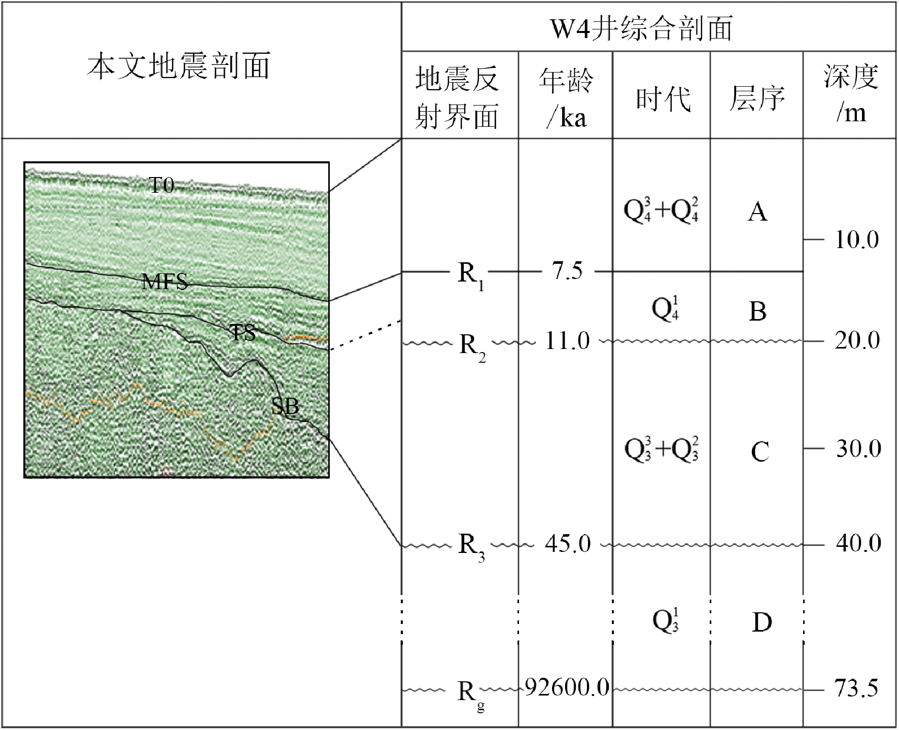
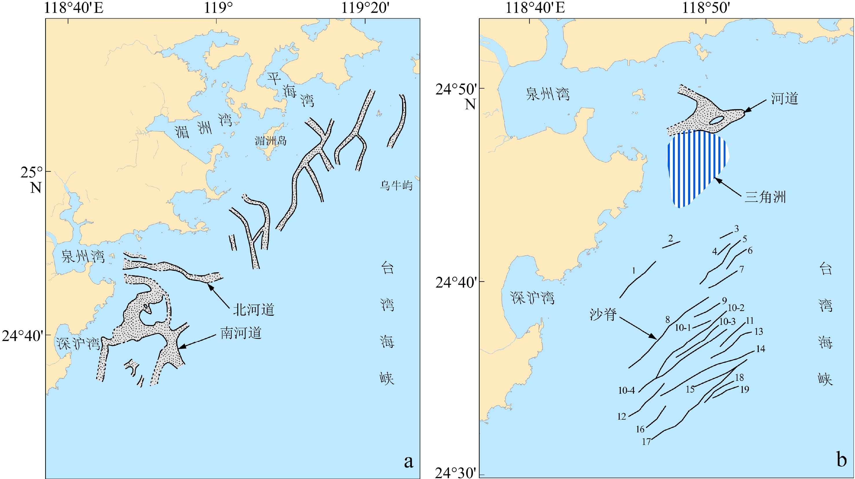
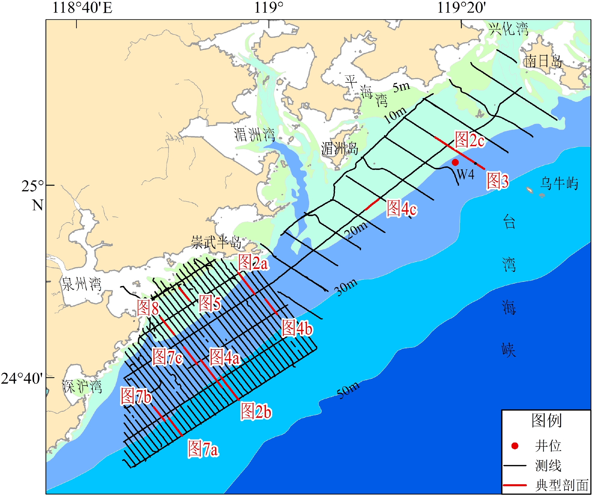
摘要: 在闽中南近海台湾海峡中西部的湄洲湾和泉州湾采用拖筏震源进行高分辨率单道浅地震调查,测线网格在南部海域为1 km×5 km,北部为约5 km×8 km。有两个区域性的强反射界面:海底面和陆相强侵蚀面。局部可以辨识海侵面、最大海泛面和基岩面。除了在晚更新世古河道等负地形区外,陆相强侵蚀面与海侵面重合,该强侵蚀面将地震剖面分隔为上层序和下层序,而海侵面又将上层序划分为全新世海相和晚更新世古河道充填相层。其中,全新世海相层为主体,全区有分布,部分海域可以分成上亚层和下亚层。在晚更新世末次低海面时期,研究区南部发育古晋江南河道和北河道,最宽分别约7~8 km和2 km,北部为密集的溪沟地貌,宽约1 km;推测随着海平面上升,古晋江河道发生堆积退缩,直至消失,时间为约12.0~9.6 kaBP,而后掩埋于全新世海相层之下。在研究区最南部,有19 条长度1 km以上的潮流沙脊埋藏于全新世海相层内,高约1~7 m,长约1.5~10 km,大体相互平行,主要发育年代可能在约10 kaBP。沙脊分为单脊型和多脊型,前者又分为单脊孤立型和单脊多列型,后者分为简单多脊型和超复多脊型,沙脊高度与下伏亚层的厚度基本上呈正相关。泉州湾口外发育小型河道和水下三角洲,主要浅埋于全新世海相层内,形成于全新世。这些埋藏特殊地貌的发育,除北部海域的溪沟外,均与晋江水沙有关。Abstract: High-resolution shallow-seismic profiles using boomer in inshore area off Meizhou Bay and Quanzhou Bay, the middle of the western Taiwan Strait were analyzed. The survey grids are 1 km×5 km in the southern area and about 5 km×8 km in the northern. The seismic profiles reveal two regional strong reflectors: T0 (sea bottom) and SB (subaerial erosion surface); and three locally recognizable: TS (transgressive surface), MFS (maximum flooding surface), and TR (rock surface). Apart from paleo-negative topography, such as river channels of MIS 2, SB coincides with TS. In addition, the seismic profiles can be divided at SB into upper sequence (USQ) and lower sequence (LSQ). The USQ is subdivided at TS into unit U1 (marine Holocene) and U2 (infillings of paleo-channel of MIS 2). During the last low sea level, the south and north channels of paleo-Jinjiang River were developed in the southern study area in 7~8 km and 2 km, the widest width, respectively. In the northern study area were developed quite dense gullies, about 1 km wide, which might be related to complicated paleo-ground and streams from Meizhou Bay region varying strongly in season. Considering sea level curves, as sea level rising, the south channels were gradually submerged landward about 12.0~9.6 kaBP. In addition, 19 buried linear tidal sand ridges in NE-SW direction within unit U1 in the southernmost part of the study area were recognized. The sand ridges are about 1~7 m high, 1.5–10 km long, and usually in intervals of several-hundred meters to about 1 km. They were mainly formed at about 10 kaBP. In terms of the profile shapes and internal structures, they could be divided into single-crest sand ridges and multiple-crests sand ridges. The former ones are in turn subdivided into isolated single-crest ridges and single-crest ridges of multiple-lines, while the latter ones, into simple multiple-crests ridges and overlapped multiple-crests ridges. A small river channel and a subaqueous delta were mainly buried inside U1 just outside Quanzhou Bay mouth. They were formed during the Holocene. The development of all these buried special geomorphological features, but gullies in the northern area, were related with sand and water discharges of paleo-Jinjiang River.
-
冲绳海槽位于东海和琉球群岛之间,具有过渡性地壳,是菲律宾海板块向欧亚板块俯冲形成的处于张裂阶段的年轻弧后盆地[1-7],其与琉球海沟、琉球岛弧构成了完整的沟-弧-盆体系,成为研究弧后扩张早期阶段的盆地演变、岩浆作用和壳幔过程的天然实验室,也是了解弧后盆地的发生和发展、地幔物质熔融及岩浆起源的一个罕见的“窗口”[8],对于认识海洋环境演化过程、了解气候环境的变化情况等具有重要意义。同时海槽内发育第四纪以来巨厚的连续沉积层,其保存并记录了陆源物质的输入、海平面变化、海洋环流等重要的沉积信息,加之其位于陆地向海洋的过渡地带,也是研究海陆相互作用及古环境变化的理想区域。特别是冲绳海槽南段是整个海槽中自全新世以来具最高沉积速率的地区[9],更成为了研究海洋环流和古气候演化的重要区域[10]。
1984年在冲绳海槽中部的伊平屋脊段发现海底热液活动以来[11],该区域便成为了中外学者研究热液活动的重点及热点地区。槽内火山和地震等构造活动剧烈,具有独特的区别于其他成熟弧后盆地的基底岩石、构造环境,发育着特殊的热液活动和成矿作用,形成了特殊的类似于陆地上古代Kuroko型火山成因的块状硫化物矿床[12]。不仅如此,由于热液活动在冲绳海槽中段和南段广泛发育,因此周围沉积物或多或少受到热液活动的影响,易在热液喷口附近区域或在离热液活动区较远的周围形成近喷口含金属沉积物或远端含金属沉积物[13-15],这些热液沉积物在元素组成上明显区别于正常远洋沉积物,主要以富集Fe、Mn、Cu、Pb、Zn、As等元素并亏损Al和Ti等元素[16-18]为主要特征。热液活动与沉积物之间通过元素交换等地球化学过程形成了紧密的联系,且海底热液区附近区域的热液沉积物是海底热液循环存在的证据, 同时也是研究海底热液系统形成与演化的重要窗口。
冲绳海槽作为一个热液活动发育的弧后盆地,前人已进行了大量与热液活动相关的研究工作,且主要集中于热液区地球物理特征、热液流体的物理化学性质、热液沉积物的矿物及地球化学特征、热液多金属硫化物堆积体的矿物及地球化学特征、热液喷口附近生物群落和基底岩石的类型及矿物学、地球化学特征的研究[8,12,19-33]。尽管如此,对于冲绳海槽南段沉积物的研究主要聚焦于矿物和化学组成方面的研究,缺少利用顺序提取法对沉积物分相态以进行元素赋存状态分析的相关研究。众所周知,通过顺序提取法进行赋存状态研究可以提供更多的元素总量难以反映的沉积物源及环境等信息,加之冲绳海槽南段构造活动较为频繁、沉积环境较为动荡以及多种来源沉积物混杂的特征导致了沉积物中的热液活动记录信号较弱。因此,本文基于Bayon[34-35]、Chester[36]、Gutjahr[37]等的顺序提取法实验,对冲绳海槽南部沉积物岩芯样品进行顺序提取实验、常量和微量元素组成分析,进而研究了沉积物中元素的赋存状态,以探讨热液活动对沉积物的元素组成及赋存状态的影响,寻找其中热液活动的沉积记录,并评估热液活动对沉积物的元素地球化学贡献和赋存状态的影响。
1. 地质背景
冲绳海槽位于欧亚板块与太平洋板块之间的汇聚带上,是西太平洋活动大陆边缘的组成部分,受菲律宾海板块俯冲形成[38-39]。冲绳海槽的北段以日本的九州岛为界,南段以中国的台湾岛为界,整体呈向东南方向凸出的新月形,总体走向为北东-南西向,长约1200 km,宽约100~150 km。基于地形和构造演化的差异,Shinjo等[38]将冲绳海槽以Tukara和Miyako断层构造带为界分为北段、中段及南段。冲绳海槽的特征是高热通量,强烈的火山活动,大量的断层发育,较强的重力异常以及弱的负地磁异常,存在基底凹陷和上地幔隆起[40-41]。俯冲的菲律宾海板块在海槽中轴线以下约150~200 km,在海槽南轴线以下约150 km[42]。菲律宾海板块俯冲的速度在海槽南段约为7 cm/a,在海槽中段约为5 cm/a[43]。冲绳海槽南段地壳的厚度为13~16 km,向北逐渐增加,最高可达30 km,中段地区的地壳厚度为16~22 km[1,44]。槽内广泛分布了来自周围大陆和岛屿的厚层碎屑沉积物,以及与弧和弧后火山活动有关的火山碎屑沉积物[26,45]。
2. 材料与方法
本文研究的沉积物岩芯HOBAB4-S2(长度24°52′49.906″N 、122°37′19.702″E,长度477 cm,)位于冲绳海槽南段的唐印热液区和第四与那国热液区之间(图1),取样水深1505 m,由中国科学院海洋研究所“科学”号考察船于2016年5月使用重力取样器采集。该岩芯沉积物主要由深灰色泥组成,偶尔可见淤泥和细砂层。作者以1 cm间隔进行取样获得了477个样品,选取了40个层位的样品进行了全岩常量、微量元素组成测试,选取了20个层位的样品进行了顺序提取实验,顺序提取法流程参考了Bayon[34]和Yu[47]等改进的实验方法,并采用李康[48]等的方法将沉积物分为碳酸盐相、铁锰氧化物相、有机结合相及残留相,并测定了各相的主量和微量元素组成。
![]()
样品处理及分析流程:首先,将沉积物样品放置烘箱中于60℃下烘干24 h。然后,取出用玛瑙研钵研磨成200目的粉末以备全岩分析测试。取40 mg粉末,加入特氟龙消解罐中,向其中加入1.5 mL浓氢氟酸和0.5 mL浓硝酸后,密封并放置加热板于150℃加热24 h。放凉至液体不会喷出,打开盖子将剩余液体加热蒸干,然后加入1 mL浓硝酸和1 mL超纯水,密封后继续放置于150℃电热板上加热24 h至样品完全溶解,再加入超纯水定容至40 g。主量元素含量的测试在青岛斯八达分析测试有限公司使用美国瓦里安公司Vrian720ES型ICP-OES完成,相对标准偏差<2%;微量元素含量的测试在青岛斯八达分析测试有限公司使用美国瓦里安公司Varian820型电感耦合等离子体质谱仪(ICP-MS)完成,相对标准偏差<5%。测试过程中采用GBW07314、GBW07315、GBW07316以及美国地质调查局玄武岩标准物质BHVO-2作为标准样品。残留相的消解步骤与沉积物全岩相同,碳酸盐相、铁锰氧化物相、有机结合相在经过顺序提取分离后,分别将其置于特氟龙消解罐中,加入1.5 mL浓氢氟酸和0.5 mL浓硝酸后,不封盖放置于150℃电热板上加热蒸至近干,然后加入1 mL浓硝酸和1 mL超纯水,密封后继续放置于150℃电热板上加热12 h,冷却后加入超纯水转移至定容瓶中定容至40 g。各相主量元素和微量元素组成的测定方法同沉积物全样。
3. 结果
3.1 岩芯沉积物不同相态中各元素含量及萃取比例的分布特征
HOBAB4-S2岩芯沉积物中主量及微量元素在各相态中的含量分布见图2,由图可见岩芯沉积物中元素在四种相态中的分布极不均匀,Al、Ti、K均表现为在残留相中的含量普遍高于其他相态。Fe在残留相中的含量最高,其次是碳酸盐相,其在铁锰氧化物相及有机结合相中的含量均较低。Mn在碳酸盐相中的含量明显高于其他相态。Cu在有机结合相中的含量高于其他三相,Pb在铁锰氧化物相中的含量高于其余相的,Zn、Co、Ni在碳酸盐相中含量明显高于其他相态。Al、Ti、K元素的总含量随岩芯深度变化不大,平均值分别为20.0%、0.9%、4.2%,较海槽表层沉积物[49]稍高。Fe元素含量随深度变化也不大,其总含量平均为16%,与海槽南段表层沉积物相比偏高。Mn元素总含量相较于海槽表层沉积物偏低,平均为0.48%。Cu、Zn、Pb元素总含量均比海槽沉积物高很多,随深度变化较大,且随深度变化趋势相同。Co、Ni元素总含量也较海槽沉积物更高,随深度变化不大,但变化趋势相同。
![]() 图 2 岩芯沉积物中元素在各相态中含量的分布F1-碳酸盐相,F2-铁锰氧化物相,F3-有机结合相,F4-残留相(下同)。虚线表示冲绳海槽南部表层沉积物元素丰度,数据引自文献[49]。Figure 2. Distribution of elemental contents of various phase states in core sedimentsF1: carbonate phase,F2: Fe-Mn oxide phase, F3: organic bound phase,F4: residual phase (same below). The dashed line indicates the elemental abundance of surface sediments in the southern of the Okinawa Trough. Data are obtained from reference [49].
图 2 岩芯沉积物中元素在各相态中含量的分布F1-碳酸盐相,F2-铁锰氧化物相,F3-有机结合相,F4-残留相(下同)。虚线表示冲绳海槽南部表层沉积物元素丰度,数据引自文献[49]。Figure 2. Distribution of elemental contents of various phase states in core sedimentsF1: carbonate phase,F2: Fe-Mn oxide phase, F3: organic bound phase,F4: residual phase (same below). The dashed line indicates the elemental abundance of surface sediments in the southern of the Okinawa Trough. Data are obtained from reference [49].为进一步确定元素含量在各相态中的分布比例,采用元素在各相态中的含量与其在沉积物中的总含量之比,即用各相态的萃取比例作萃取比例分布图(图3)。由图可见,几乎全部的Al、K和Ti都赋存于残留相中,尤其是Al、Ti在整个岩芯各层位沉积物中的萃取比例均在90%以上,而K的萃取比例稍低,但平均在70%以上,且含量随深度变化微弱,另有小部分进入碳酸盐相中,基本不赋存于有机结合相及铁锰氧化物相中。Fe主要赋存于残留相,其平均萃取比例约为50%,次要赋存相为碳酸盐相,平均萃取比例为25%,另有少部分赋存在铁锰氧化物相与有机结合相中。Mn主要赋存于碳酸盐相,萃取比例平均为78%,且萃取比例随深度变化不大,而在其余三相中萃取比例均极低,特别是在有机结合相中,Mn萃取比例很低,平均为5%,在铁锰氧化物相中Mn萃取比例变化较为明显,但平均萃取比例也很低,约为12%。
![]() 图 3 岩芯沉积物中各元素在不同相态中萃取比例的分布Figure 3. Distribution of extraction ratios of elements in different phases in core sediments
图 3 岩芯沉积物中各元素在不同相态中萃取比例的分布Figure 3. Distribution of extraction ratios of elements in different phases in core sedimentsCu的赋存形态在不同的层位也具有较大的差异,整体上主要赋存于有机结合相中(51%),其次是碳酸盐相和残留相中,二者萃取比例基本相当,平均分别为24%和19%。而铁锰氧化物相的萃取比例很低,平均只有8%,但在某些层位变化较大。Pb的赋存状态较为特别,其主要赋存于铁锰氧化物相与碳酸盐相,且在铁锰氧化物相与碳酸盐相中的萃取比例随深度变化较大,两者萃取比例变化趋势呈现相反的特征,萃取比例的平均值分别为42%与47%,极少部分赋存于有机结合相与残留相中,且在其中的平均萃取比例均低于5%。
Zn与Co、Ni元素的萃取比例分布很相似,均主要赋存于碳酸盐相中,平均萃取比例分别为33%、58%、47%,这3个元素中Co在碳酸盐相中的平均萃取比例最高。Co元素有少部分进入除碳酸盐相的其余三相中,且萃取比例随深度变化微弱。Zn和Ni元素的次要存在相均为残留相,在残留相中的萃取比例平均分别为28%和34%,且Zn元素在残留相中萃取比例的变化较Co元素的变化大。
综上所述,在铁锰氧化物相与有机结合相中大部分金属元素含量较低甚至缺乏,除Cu大部分赋存于有机结合相中,Pb大部分赋存于铁锰氧化物相中之外,大部分元素在铁锰氧化物相及有机结合相中的萃取比例均较低,在铁锰氧化物相中的萃取比例均低于26%,在有机结合相中的萃取比例均低于25%。整体上看,各元素赋存状态极不均匀。除Al、Ti外,其余元素在碳酸盐相中均有所赋存,尤其以Mn、Co在该相中占比最高,其余元素占比的平均值均高于30%。除Al、Ti、K外其余元素在铁锰氧化物相中均有存在,但所占比例不高,除Pb外萃取比例均较低。除K、Mn、Pb有极少量存在于有机结合相中外,其余元素在有机结合相中均有存在,但所占比例均不高,除Cu在该相中萃取比例较高外其余元素在该相中萃取比例均较低。除Mn、Pb有极少量存在于残留相中外,其余元素在残留相中均有存在,Al、Ti、K、Fe、Ni均在残留相中占主要优势。
残留相是所研究的主量元素中最主要的赋存形式,除Mn以外,残留相中各元素的含量及萃取比例一般均高于其余相态,尤其以Al、Ti最为典型,元素含量93%以上均赋存于残留相中。残留相中主要包括碎屑硫酸盐、铝硅酸盐和少量难溶硫化物或难溶有机质[50]。因此岩芯沉积物中多种元素主体赋存于残留相中的特征反映了这些元素在沉积物中主要以碎屑硅酸盐形式赋存,同时也反映了该区陆源或火山碎屑形式的供给对沉积物的元素聚集有着重要贡献。这与前人在该区的研究结果相一致[49]。
碳酸盐相是岩芯沉积物中元素的另一主要赋存形态,除Al、Ti之外其余元素在该相态中均有所赋存,且表现出岩芯沉积物该相态中K、Cu、Zn、Pb的元素含量与萃取比例变化趋势一致的特征,在该相态中Fe、Mn、Co、Ni元素的含量与萃取比例变化趋势呈大致相同的特征。
值得注意的一点是,除Al、Ti、K外其余的金属元素在铁锰氧化物相中的萃取比例随深度变化趋势相同,且在该相态中Cu、Zn、Pb、Co、Ni、Fe、Mn元素的含量随深度变化趋势一致同时与萃取比例随深度变化情况基本相同(图4、图5)。可见Cu、Zn、Pb、Co、Ni、Fe、Mn元素的萃取比例在78、190、294、420 cm层位处出现高值(图4、图5)。Pb在铁锰氧化物相中的萃取比例变化范围极大,萃取比例最大可达61%,最低为19%。Cu、Zn、Co、Fe的萃取比例均在30%以内变化,Ni和Mn的萃取比例相对较低且均在20%以内变化。Pb的元素含量在岩芯铁锰氧化物相各层位中也是最高的,同时变化范围也很大,元素含量最高为511 μg/g,最低为42 μg/g,含量平均值为150 μg/g。岩芯铁锰氧化物相中Zn的元素含量在11~67 μg/g之间变化,平均值为41 μg/g。Cu的元素含量变化范围是3.3~40 μg/g,平均值为16.7 μg/g。Ni的元素含量变化区间为2.8~19.6 μg/g,平均值为9.4 μg/g。Co的元素含量变化范围为1.8~12.6 μg/g,平均值为6.3 μg/g。Fe、Mn的含量在铁锰氧化物相中均较低,其中Fe的元素含量变化范围为0.6%~3.9%,平均值为1.8%。元素Mn的含量在铁锰氧化物相中最低,变化范围为0.01%~0.06%,平均值为0.03%。
![]() 图 4 铁锰氧化物相中几种金属元素萃取比例随深度变化Figure 4. Variation of extraction ratio of several metal elements in Fe-Mn oxide phase with depth
图 4 铁锰氧化物相中几种金属元素萃取比例随深度变化Figure 4. Variation of extraction ratio of several metal elements in Fe-Mn oxide phase with depth![]() 图 5 铁锰氧化物相中元素含量随深度变化Figure 5. Variation of elemental content in Fe-Mn oxide phase with depth
图 5 铁锰氧化物相中元素含量随深度变化Figure 5. Variation of elemental content in Fe-Mn oxide phase with depth3.2 岩芯沉积物的稀土元素地球化学特征
可以看出,岩芯铁锰氧化物相中稀土元素总量随深度变化趋势与Fe、Mn、Cu、Zn、Pb、Co、Ni元素在铁锰氧化物相中的萃取比例及含量随深度变化趋势一致(图6),稀土元素总量变化范围很大,最低只有15 μg/g,最高达到122 μg/g,平均值为55.3 μg/g。轻稀土元素(La—Eu)变化范围为12.8~104 μg/g,平均值46.9 μg/g。重稀土元素(Gd—Lu)总量变化范围为2.4~18.1 μg/g,平均值8.4 μg/g。轻稀土元素与重稀土元素均表现为统一的含量变化趋势,同时该相态中轻稀土元素明显较重稀土元素富集。
![]() 图 6 铁锰氧化物相中稀土元素总量随深度变化Figure 6. Variation of total rare earth elements in Fe-Mn oxide phase with depth
图 6 铁锰氧化物相中稀土元素总量随深度变化Figure 6. Variation of total rare earth elements in Fe-Mn oxide phase with depth岩芯各层位的铁锰氧化物相中稀土元素球粒陨石标准化配分模式图(图7)显示,其整体上呈现右倾趋势,具有明显Eu负异常(δEu平均为0.67),轻微Ce正异常(δCe平均为1.07),各个层位中铁锰氧化物相的稀土元素球粒陨石标准化配分模式大体一致,该特征与南大西洋受热液活动影响较小的沉积物[52]的铁锰氧化物相的稀土元素球粒陨石标准化配分模式相似(δEu=0.71,δCe=1.60),相较于南大西洋受热液活动影响较小的沉积物没有较为明显的Ce正异常,Eu的负异常则较为相似。
![]()
$$ {\delta }\text{Eu}=\frac{\text{E}{\text{u}}_{\text{N}}}{\sqrt{\text{S}{\text{m}}_{\text{N}}\times \text{G}{\text{d}}_{\text{N}}}}{\text ,}{\delta }\text{Ce}=\frac{\text{C}{\text{e}}_{\text{N}}}{\sqrt{\text{L}{\text{a}}_{\text{N}}\times P{r}_{\text{N}}}} $$ 由稀土元素在铁锰氧化物相和残留相中的萃取比例分布(图8),可以看出稀土元素在铁锰氧化物相中的萃取比例在10%~30%之间,稀土元素萃取比例平均值低于20%。而在残留相中,基本上所有稀土元素的萃取比例明显高于30%,个别稀土元素萃取比例可达70%以上,平均萃取比例为44%,对比发现稀土元素主要赋存于残留相中。所有的稀土元素均显示了同一变化趋势,反映了其极为相似的地球化学性质。
![]() 图 8 铁锰氧化物相(a)和残留相(b)中稀土元素萃取比例分布图Figure 8. Distribution of extraction ratio of rare earth elements in Fe-Mn oxide phase (a) and residual phase (b)
图 8 铁锰氧化物相(a)和残留相(b)中稀土元素萃取比例分布图Figure 8. Distribution of extraction ratio of rare earth elements in Fe-Mn oxide phase (a) and residual phase (b)4. 讨论
前人的研究认为,铁锰氧化物通过对周围水体中元素的清扫作用,可以从周围海水捕获大量元素,同时通过前人对冲绳海槽中段热液区附近沉积物的顺序提取分析的研究可知,铁锰氧化物结合态是热液源组分在沉积物中的主要赋存形式[47]。冲绳海槽南段热液活动发育,岩芯沉积物周围有唐印热液区与第四与那国热液区,岩芯沉积物的取样位置距离东南部的第四与那国热液活动区大约10 km,距离西北部的唐印热液区大约20 km,岩芯沉积物取自于唐印热液区和第四与那国热液区之间(图1),指示了样品中很可能有热液来源物质的加入,因此推测岩芯在78、190、294、420 cm层位处的沉积物经历了热液活动的影响,并且改变了该层位沉积物中元素的赋存状态,从而影响岩芯沉积物整体的元素富集形式。对于唐印热液区的研究表明,热液羽流会在洋流作用下向南或东南方向迁移扩散[53]。深海沉积物中的热液组分主要通过两种方式形成:(1)热液物质从中性浮力羽流中扩散和沉降以及热液的横向扩散形成广泛分布的高Fe(20.01%~39.33%)、Mn(4.00%~13.65%)含量的热液沉积物[17,54-56],(2)在喷口附近形成的硫化物的大规模冲刷和侵蚀。前人的研究表明,热液羽流中的颗粒大小不超过70 μm[18],其中大多数颗粒的直径都小于2 μm,而硫化物颗粒的粒度大于63 μm,同时HOBAB4-S2岩芯中的Fe(2.66%~4.72%)、Mn(0.04%~0.05%)含量均低于由热液羽流扩散形成的热液沉积物的Fe、Mn含量,因此可以认为热液活动形成的硫化物颗粒会通过热液羽流的迁移和输送而在距离热液喷口的远端剧烈沉降至海底沉积。唐印热液区的热液沉淀物中富含Fe、Zn、Pb及自然硫,含金属沉积物中富含黄铁矿、闪锌矿、方铅矿和少量磁黄铁矿。第四与那国热液区中的硫化物主要包括闪锌矿和少量黄铁矿、黄铜矿。黄铁矿、黄铜矿、闪锌矿、方铅矿中富含Fe、Cu、Zn、Pb,而Yang 等[57]在岩芯沉积物中观察到了黄铁矿、方铅矿、黄铁矿和少量闪锌矿,其组成与唐印热液区硫化物更为相似因此认为热液组分来源于唐印热液区。因此可以确定沉积物受热液活动影响,且可能同时接受了来自唐印热液区及第四与那国热液区的热液硫化物的贡献,使Fe、Cu、Zn、Pb等元素在铁锰氧化物相中的含量及萃取比例在几个层位的明显偏高。通过浮游有孔虫的挑选及AMS 14C测年,测年结果通过Calib7.1软件校正后显示岩芯沉积物底部沉积年龄为624 aBP[58]。Fujiwara 等[59]从第四与那国热液区的热液硫化物矿床中提取的重晶石进行电子自旋共振(ESP)年龄研究时,发现取自活动的热液喷口烟囱体的样品年龄为580~990 aBP,来自活动的热液喷口的样品显示出较轻的年龄为200~260 aBP,均表明第四与那国热液区范围内近1 000年来发生过频繁的热液活动现象,因此沉积物岩芯沉积过程中受到频繁的热液活动影响是极为可能的。通过逐次线性内差法对表1中的年代学数据进行计算,发现本次研究中的4个受到热液活动影响的层位沉积年代分别为99、187、312、448 aBP。
表 1 HOBAB4-S2岩芯碳同位素测年结果Table 1. Results of carbon isotope dating for HOBAB4-S2 cores深度/cm 材料 AMS 14C
年龄/aBP校正年龄/aBP 数据来源 中间年龄 年龄范围/2σ 74 浮游有
孔虫290±30 35 0~70 文献[58] 125 560±30 159 260~47 283 690±30 304 424~230 387 730±30 346 432~268 477 1090±30 624 682~541 Hsu[60]等运用顺序提取法对冲绳海槽南段的热液活动区和非热液活动区沉积物中Fe、Mn、Al等元素进行对比研究,同样发现受热液活动影响的沉积物在铁锰氧化相中的Fe、Mn元素萃取比例比非热液影响的沉积物的萃取比例高,尤其是Mn的变化更为明显,而Al萃取比例则很低,亦变化不大。而与之不同的是,本次顺序提取分析中Pb在铁锰氧化物相的萃取比例变化最大,其萃取比例最高可达62%,最低只有18%,这可能是沉积物中热液来源的硫化物中方铅矿含量较高且热液活动强度的变化所导致的。
通过对海槽南部第四与那国热液流体稀土元素的研究发现,随着流体喷出海底与海水的混合及扩散,流体中的正Eu异常越弱,而负Ce异常明显增加[61]。流体中溶解的Fe2+被氧化为氧化物或氢氧化物迅速沉积下来,而热液柱中的Fe氧羟化物则对热液流体及周围海水的稀土元素均具强烈的清扫作用。热液柱中Fe-Mn颗粒物的快速沉积及其对热液柱和海水中稀土元素的强烈清扫作用会对下覆沉积物中的稀土元素组成产生影响[62]。热液柱中也会携带一些硫化物或硫酸盐颗粒,这些颗粒物及Fe-Mn氧羟化物沉降到下覆沉积物中,也可能会对下覆沉积物中的元素组成产生影响[63]。在正常海水中Ce3+易在氧化还原条件下被氧化成Ce4+形成CeO2沉淀而使海水显示出明显的负Ce异常,而海洋自生作用形成的铁锰结核或结壳因吸附海水中的Ce及其他稀土元素,通常会表现出强烈的Ce正异常。因此HOBAB4-S2岩芯铁锰氧化物相态中出现非常轻微的Ce正异常,可以认为是热液活动形成的热液柱中的Fe-Mn氧化物等颗粒物对周围海水及热液柱中稀土元素的清扫,或者是受海水的影响加强所导致的。热液柱中的Fe-Mn颗粒物沉降到下覆沉积物后,会不断改变沉积物的REE配分模式,使沉积物的Ce出现正异常,出现类似于水成型铁锰结壳的REE配分模式,且同时由于铁锰氧化物对热液流体中稀土元素的清扫,沉积物铁锰氧化物相中的稀土元素球粒陨石标准化配分模式显示了热液流体中的轻稀土元素富集,重稀土元素亏损的特征,而其显示的Eu负异常与热液流体的强烈正异常明显区别,可能是距离热液喷口较远,热液流体离开喷口后形成的热液柱随着其远离热液喷口向远处扩散迁移时会逐渐显示海水的稀土元素特征[15,24],同时被铁锰氧化物吸附海水中的稀土元素,这与该区沉积环境动荡、沉积物组成以陆源物质为主掩盖了部分热液活动信息以及该区较快的沉积速率有极大的关系。
众所周知,Cu与有机质如海藻等微生物分解的腐殖酸、代谢物具有很强的络合或生物化学反应能力,因此Cu在有机结合相中的高萃取比例表明有机质对Cu有着较强的吸附络合作用。而Pb主要赋存于铁锰氧化物相,表明热液活动产生的硫化物中方铅矿含量较高,对Pb的元素含量贡献较大。除陆源元素Al、Ti外的其余元素均在碳酸盐相有所赋存,Mn是碳酸盐相中萃取比例最高的元素,表明生物作用是本区的Mn、Co等金属元素进入沉积物的主要机制,Mn在碳酸盐相的萃取比例极高与生物化学作用形成的自生组分如锰结核有关。除典型的陆源代表元素Al、Ti、K外的金属元素在铁锰氧化物相均有存在但所占比例不大,则表明热液活动对这些元素均有一定的贡献。除Cu外的其他元素在有机结合相中的萃取比例明显较低,表明元素与有机质活性基团或硫离子结合的作用较低,与之对应的有机质对于各元素的吸附能力较弱。Mn、Pb在残留相中占比极低,Al、Ti、K、Fe、Ni均在残留相中占主要优势,由于Al可能以硅酸盐结晶矿物的形式存在,Ti可能以类质同相替代而存在于黏土矿物中,K可能以长石的形式存在,而残留相中的金属元素主要存在于黏土、长石、石英等硅酸盐矿物晶格中,因此,残留相中的元素主要来源于陆源碎屑中的硅酸盐、铝硅酸盐矿物。
由铁锰氧化相和残留相中的稀土元素萃取比例对比,发现稀土元素主要赋存于残留相中,即残留相中赋存的陆源稀土元素明显高于铁锰氧化物相中的热液源稀土元素在沉积物总稀土元素含量中的占比,热液源的稀土元素对于沉积物中总的稀土元素的贡献并不占主导地位,而残留相中难溶的陆源碎屑物质本身存在的稀土元素或在沉积过程中进一步吸收周围海水中的稀土对于沉积物总的稀土元素贡献占明显优势。赋存于铁锰氧化物相中的热液源稀土元素总量较低且由于距离热液喷口较远而受热液活动的影响较小,而本身存在于热液来源硫化物中的Fe、Cu、Zn、Pb、Mn则主要赋存在铁锰氧化物相中,因此各元素含量及萃取比例在铁锰氧化物相中的的变化程度受热液活动强度变化的直接影响较大。
5. 结论
(1)对冲绳海槽南部岩芯沉积物进行了顺序提取分析,结果表明残留相是该岩芯沉积物中元素Fe、Mn、Al、Ti、K、Cu、Zn、Pb、Co、Ni的最主要赋存态,碳酸盐相是次要赋存态,表明陆源碎屑沉积与生物碳酸盐沉积是该区的主要沉积作用方式,陆源物质与生源物质占沉积物来源的主导地位。
(2)与热液活动相关的Cu、Zn、Pb、Fe、Mn等金属元素在铁锰氧化物相中的萃取比例与其含量以及稀土元素总量随深度变化趋势相同,且在4个层位出现异常高值,结合前人对于周围热液区的热液喷口喷发周期资料分析,认为热液活动对沉积物中元素组成及赋存状态有显著影响。
(3)岩芯铁锰氧化物相的稀土元素球粒陨石标准化配分模式显示了极轻微的Ce正异常和明显的Eu负异常,以及轻稀土元素较重稀土元素更为富集的特征,这与南大西洋受热液活动影响较小的沉积物铁锰氧化物相的稀土元素配分模式类似,是热液柱中的铁锰氧化物吸附海水及热液柱中的稀土元素,且该处岩芯沉积物距离热液活动区较远、受热液活动影响较小所致。
致谢:对中国科学院海洋研究所“科学号”考察船所有船上队员为采集样品、数据和资料所做出的贡献表示感谢。
-
![]()
![]()
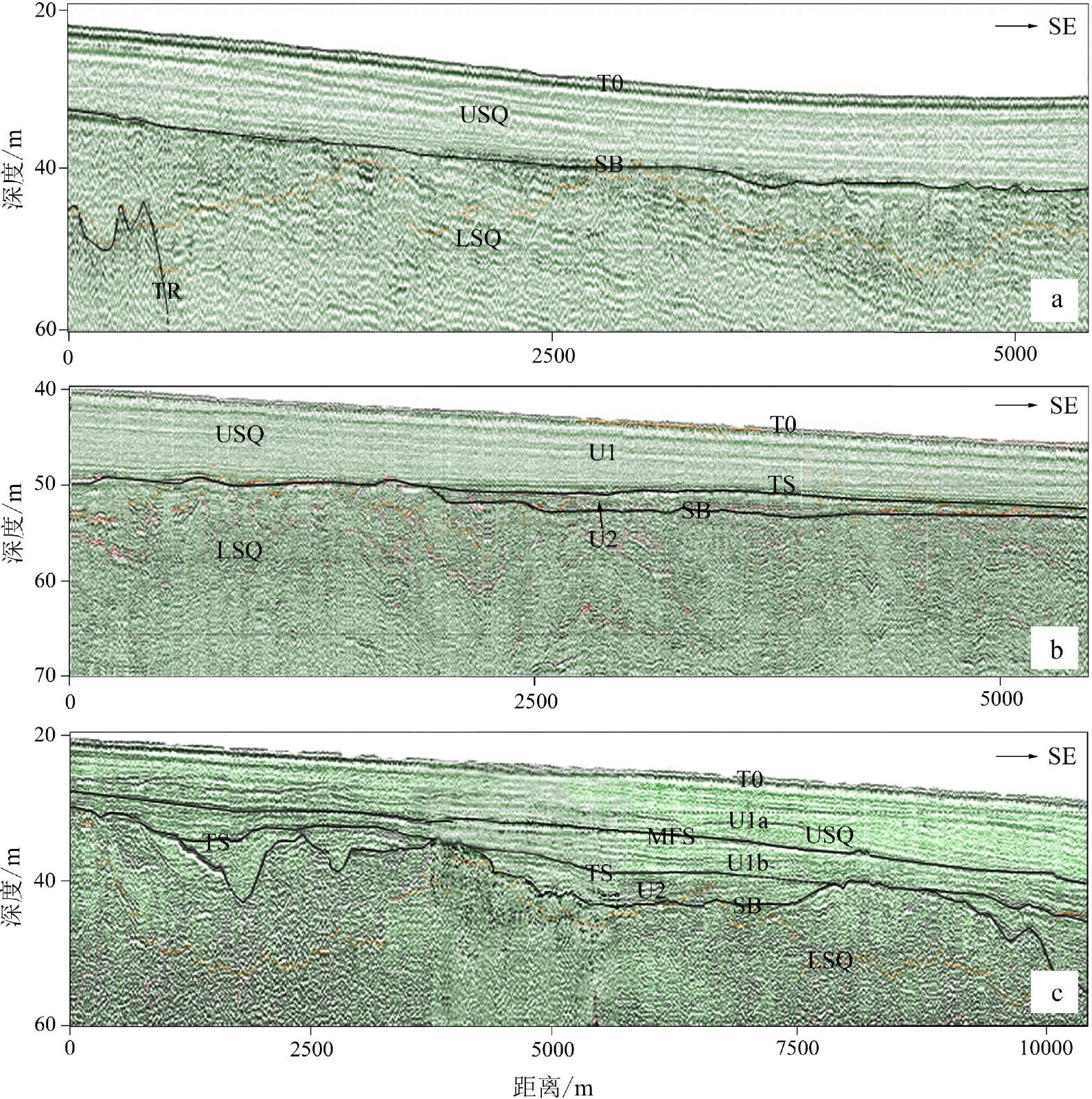
图 4 典型地震层序和MIS 2古河道
a. 南部外海区,b. 南部近岸区,c. 北部外海区。
Figure 4. Typical seismic sequences and paleo-river channels of MIS 2
a. Southern outer sea; b. southern inshore sea; c. northern outer sea.
![]()
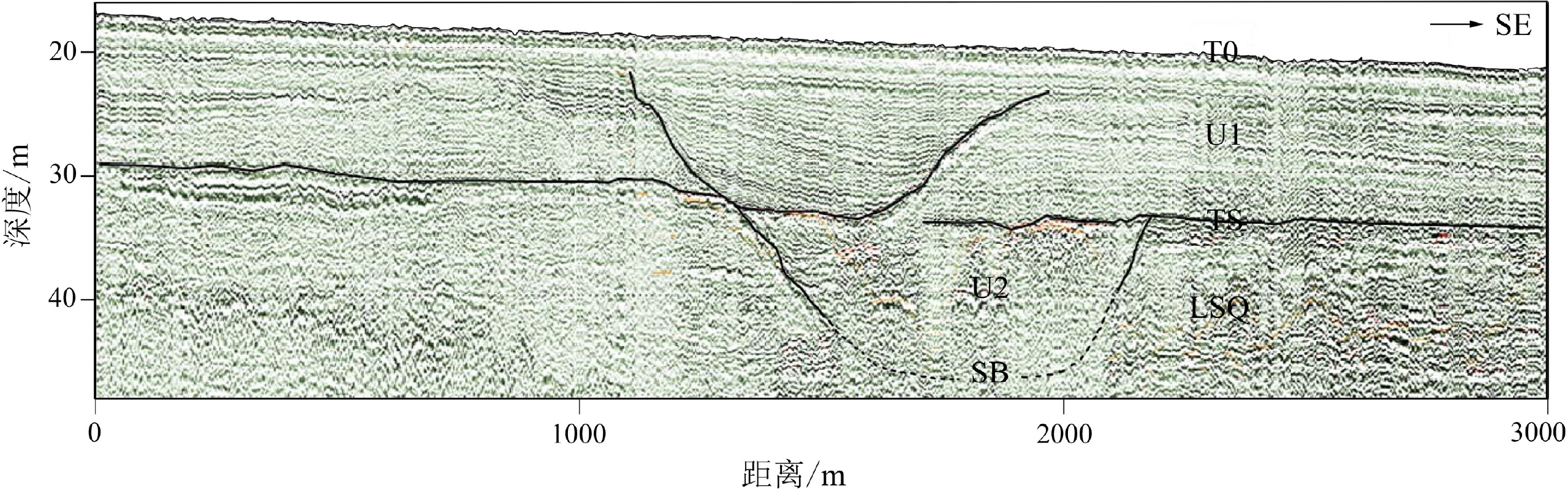
图 5 MIS 1古河道切入U1层后被其顶部地层覆盖
Figure 5. Paleo-river channel of MIS 1 incised U1 and later buried by the top layers
![]()
图 6 埋藏特殊地貌分布图
a. MIS 2古河道,b. MIS 1潮流沙脊、河道和三角洲。
Figure 6. Distribution of buried special geomorphologic features
a. Paleo-river channels of MIS 2; b. tidal sand ridges, river channels and delta of MIS 1.
![]()
图 7 埋藏潮流沙脊的典型地震剖面
a. 多列单脊型沙脊,形成于U1b之上,b. 超复多脊型沙脊,形成于U1b之上,c. 多列单脊型沙脊,基本上形成于TS之上。
Figure 7. Typical seismic profiles showing buried tidal sand ridges
a. Single-crest ridges of multiple-lines atop U1b; b. an overlapped multi-crest sand ridge atop U1b; c. single-crest ridges of multiple-lines, largely atop TS surface.
表 1 沙脊典型(最大)高度和下伏U1b厚度
Table 1 Typical (maximum) height of sand ridges and thickness of their underlain U1b
沙脊编号 TS深度/m 海底深度/m 沙脊高度/m U1b厚度/m 沙脊分区 SR17 47.2 37.7 5.7 3.2 南小区 SR15 45.5 37.2 4.7 1.2 南小区 SR10-4 44.4 33.7 7.2 1.2 南小区 SR07 42.0 32.7 4.4 1.6 南小区 SR05 40.7 27.7 2.0 ~0* 东北小区 SR04 40.0 27.7 3.6 0.4 东北小区 SR01 36.0 25.9 3.6 1.6 西北小区 注:*:~0是指U1b的厚度在剖面中难以分辨出,估计约为0 m。  下载: 导出CSV
-
[1] 许江, 朱嘉, 张异彪, 等. 平潭海域地震层序及地层层序特征[J]. 地球物理学进展, 2010, 25(2):396-402 doi: 10.3969/j.issn.1004-2903.2010.02.004 XU Jiang, ZHU Jia, ZHANG Yibiao, et al. Characteristics of seismic sequence and stratigraphic sequence in the Pingtan sea area [J]. Progress in Geophysics, 2010, 25(2): 396-402. doi: 10.3969/j.issn.1004-2903.2010.02.004
[2] 蔡锋, 曹超, 周兴华, 等. 中国近海海洋: 海底地形地貌[M]. 北京: 海洋出版社, 2013: 22-23, 177-180 CAI Feng, CAO Chao, ZHOU Xinghua, et al. China Offshore Oceanography-Topography and Geomorphology[M]. Beijing: China Ocean Press, 2013: 22-23, 177-180.
[3] 卢惠泉, 吴承强, 许艳. 闽江口外潮流沙脊群特征与成因[J]. 海洋地质与第四纪地质, 2014, 34(2):27-36 LU Huiquan, WU Chengqiang, XU Yan. Characteristics and origin of the tidal sand ridges off the Minjiang River estuary, southeastern China [J]. Marine Geology & Quaternary Geology, 2014, 34(2): 27-36.
[4] 刘阿成, 唐建忠, 吴巍, 等. 闽江口外海域晚第四纪地震层序和古河道演变[J]. 海洋与湖沼, 2019, 50(1):61-73 doi: 10.11693/hyhz20180400087 LIU A’cheng, TANG Jianzhong, WU Wei, et al. Seismic sequences and evolution of paleo-river channels of late Quaternary off Minjiang River estuary, southeast China [J]. Oceanologia et Limnologia Sinica, 2019, 50(1): 61-73. doi: 10.11693/hyhz20180400087
[5] 刘阿成, 张杰, 唐建忠. 闽江口外海域全新统地震地层学特征和沉积作用[J]. 海洋学报, 2020, 42(11):49-61 LIU A’cheng, ZHANG Jie, TANG Jianzhong. Characteristics of seismic stratigraphy and sedimentation of the Holocene off the Minjiang River estuary, southeast China [J]. Haiyang Xuebao, 2020, 42(11): 49-61.
[6] 刘阿成, 张杰, 唐建忠. 闽江口外海域MIS5和MIS3的地震地层学特征和古环境[J]. 应用海洋学学报, 2022, 41(1):109-119 LIU A’cheng, ZHANG Jie, TANG Jianzhong. Characteristics of seismic stratigraphy and paleoenvironment during MIS 5 and MIS 3 off the Minjiang Estuary, Southeast China [J]. Journal of Applied Oceanography, 2022, 41(1): 109-119.
[7] 陈承惠, 蓝东兆, 于永芬, 等. 台湾海峡西部海域晚第四纪地层[J]. 第四纪研究, 1990(4):301-307 doi: 10.3321/j.issn:1001-7410.1990.04.002 CHEN Chenghui, LAN Dongzhao, YU Yongfen, et al. Late quaternary stratigraphy in the western Taiwan Strait [J]. Quaternary Sciences, 1990(4): 301-307. doi: 10.3321/j.issn:1001-7410.1990.04.002
[8] Liu J P, Xu K H, Li A C, et al. Flux and fate of Yangtze River sediment delivered to the East China Sea [J]. Geomorphology, 2007, 85(3-4): 208-224. doi: 10.1016/j.geomorph.2006.03.023
[9] 许江, 赵绍华, 李海东, 等. 闽南海岸带浅层地震层序特征[J]. 地球物理学进展, 2011, 26(2):498-504 doi: 10.3969/j.issn.1004-2903.2011.02.014 XU Jiang, ZHAO Shaohua, LI Haidong, et al. Characteristics of Min-nan offshore shallow seismic sequence [J]. Progress in Geophysics, 2011, 26(2): 498-504. doi: 10.3969/j.issn.1004-2903.2011.02.014
[10] 杜文波, 黄文凯, 朱红涛, 等. 台湾海峡西部海域沉积体系、地层架构与油气勘探前景[J]. 中国地质, 2020, 47(5):1542-1553 DU Wenbo, HUANG Wenkai, ZHU Hongtao, et al. Sedimentary system, stratigraphic architecture and petroleum exploration prospect in the western Taiwan Strait [J]. Geology in China, 2020, 47(5): 1542-1553.
[11] 彭学超, 姚伯初. 台湾海峡西部地震地层分析[J]. 海洋地质与第四纪地质, 1993, 13(2):49-63 PENG Xuechao, YAO Bochu. Seismic stratigraphic analysis of the western Taiwan Strait [J]. Marine Geology & Quaternary Geology, 1993, 13(2): 49-63.
[12] 周勐佳, 吴自银, 马胜中, 等. 台湾海峡晚更新世以来的高分辨率地震地层学研究[J]. 海洋学报, 2016, 38(9):76-88 ZHOU Mengjia, WU Ziyin, MA Shengzhong, et al. High resolution seismic stratigraphy research in the Taiwan Strait since late Pleistocene [J]. Haiyang Xuebao, 2016, 38(9): 76-88.
[13] 吴自银, 温珍河. 中国东部海域海底地貌图[M]. 北京: 科学出版社, 2019. WU Zhiyin, WEN Zhenhe. Submarine geomorphologic map of Eastern China Seas[M]. Beijing: Science Press, 2019.
[14] 吴自银, 温珍河. 中国东部海域海底沉积物类型图[M]. 北京: 科学出版社, 2019. WU Zhiyin, WEN Zhenhe. Submarine sediment type map of Eastern China Seas[M]. Beijing: Science Press, 2019.
[15] 曾成开, 朱永其, 王秀昌. 台湾海峡的底质类型与沉积分区[J]. 台湾海峡, 1982, 1(1):54-61 ZENG Chengkai, ZHU Yongqi, WANG Xiuchang. Bottom material types and sedimentation districts in Taiwan Strait [J]. Journal of Oceanography in Taiwan Strait, 1982, 1(1): 54-61.
[16] 《中国海湾志》编纂委员会. 中国海湾志: 第八分册: 福建省南部海湾[M]. 北京: 海洋出版社, 1993: 1-74. Compiling Commission of Chinese Bays Annals. Chinese Bays Annals: Volume Eight: Bays of southern Fujian Province[M]. Beijing: China Ocean Press, 1993: 1-74.
[17] Tang C, Zhou D, Endler R, et al. Sedimentary development of the Pearl River Estuary based on seismic stratigraphy [J]. Journal of Marine Systems, 2010, 82(S1): S3-S16.
[18] 刘阿成, 陆琦, 吴巍. 南黄海太阳沙西侧海域晚第四系地震层序和沉积环境演变[J]. 海洋学研究, 2017, 35(2):11-22 doi: 10.3969/j.issn.1001-909X.2017.02.002 LIU A’cheng, LU Qi, WU Wei. Seismic sequences and sedimentary environment evolution of Late Quaternary west of Taiyangsha Ridge in the South Yellow Sea [J]. Journal of Marine Sciences, 2017, 35(2): 11-22. doi: 10.3969/j.issn.1001-909X.2017.02.002
[19] 曾从盛. 闽东北沿海晚第四纪海侵与海面变动[J]. 福建师范大学学报:自然科学版, 1997, 13(4):94-101 ZENG Congsheng. Transgressions and sea level changes along the northeast coast of Fujian during the Late Quaternary [J]. Journal of Fujian Teachers University:Natural Science, 1997, 13(4): 94-101.
[20] 徐家声. 黄海晚更新统表层与全新统底层的沉积相及其界面特征[J]. 海洋地质与第四纪地质, 1989, 9(1):53-62 doi: 10.16562/j.cnki.0256-1492.1989.01.008 XU Jiasheng. Characteristics of stratigraphic boundary between Late Pleistocene and early Holocene serieses and their sedimentary facies in the Yellow Sea [J]. Marine Geology & Quaternary Geology, 1989, 9(1): 53-62. doi: 10.16562/j.cnki.0256-1492.1989.01.008
[21] 王雨灼. 福建省第四纪地层的划分[J]. 福建地质, 1990, 9(4):289-306 WANG Yuzhuo. The classification of quaternary strata in Fujian Province [J]. Geology of Fujian, 1990, 9(4): 289-306.
[22] 王律江, 鲁一江, 钱建兴, 等. 南海北部晚第四纪同位素地层学及历史[C]//南海晚第四纪古海洋学研究. 青岛: 青岛海洋大学出版社, 1992: 11-22. WANG Lvjiang, LU Yijiang, QIAN Jianxing et al. Late Quaternary oxygen isotope stratigraphy and sedimentation history of the northern South China Sea[C]//Contributions to late Quaternary paleoceanography of the South China Sea. Qingdao: Qingdao Ocean University Press, 1992: 11-22.
[23] 夏东兴, 刘振夏. 潮流脊的形成机制和发育条件[J]. 海洋学报, 1984, 6(3):361-367 XIA Dongxing, LIU Zhenxia. Formation mechanism and development conditions of tidal sand ridges [J]. Acta Oceanologica Sinica, 1984, 6(3): 361-367.
[24] Dyer K R, Huntley D A. The origin, classification and modelling of sand banks and ridges [J]. Continental Shelf Research, 1999, 19(10): 1285-1330. doi: 10.1016/S0278-4343(99)00028-X
[25] Houbolt J J H C. Recent sediments in the Southern Bight of the North Sea [J]. Geologie en Mijnbouw, 1968, 47(4): 245-273.
[26] Caston V N D. Linaer sand banks in the southern North Sea [J]. Sedimentology, 1972, 18(1-2): 63-78. doi: 10.1111/j.1365-3091.1972.tb00003.x
[27] Kenyon N H, Belderson R H, Stride A H, et al. Offshore tidal sand-banks as indicators of net sand transport and as potential deposits[M]//Nio S D, Shüttenhelm R T E, Van Weering T C E. Holocene Marine Sedimentation in the North Sea Basin. Oxford: Blackwell Scientific Pub. , 1981: 257-268.
[28] Huthnance J M. On one mechanism forming linear sand banks [J]. Estuarine, Coastal and Shelf Science, 1982, 14(1): 79-99. doi: 10.1016/S0302-3524(82)80068-6
[29] 印萍. 东海陆架冰后期潮流沙脊地貌与内部结构特征[J]. 海洋科学进展, 2003, 21(2):181-187 doi: 10.3969/j.issn.1671-6647.2003.02.007 YIN Ping. Geomorphology and internal structure of postglacial tidal sand ridges on the East China Sea shelf [J]. Advances in Marine Science, 2003, 21(2): 181-187. doi: 10.3969/j.issn.1671-6647.2003.02.007
[30] 刘振夏, 余华, 熊应乾, 等. 东海和凯尔特海潮流沙脊的对比研究[J]. 海洋科学进展, 2005, 23(1):35-42 doi: 10.3969/j.issn.1671-6647.2005.01.005 LIU Zhenxia, YU Hua, XIONG Yingqian, et al. A comparative study on tidal sand ridges in the East China Sea and Celtic Sea [J]. Advances in Marine Science, 2005, 23(1): 35-42. doi: 10.3969/j.issn.1671-6647.2005.01.005
[31] 吴自银, 金翔龙, 李家彪, 等, 东海外陆架线状沙脊群[J]. 科学通报, 2006, 51(1): 93-103 WU Ziyin, JIN Xianglong, LI Jiabiao, et al. Linear sand ridges on the outer shelf of the East China Sea[J]. Chinese Science Bulletin, 2005, 50(21): 2517-2528.
[32] 吴自银, 金翔龙, 曹振轶, 等. 东海陆架沙脊分布及其形成演化[J]. 中国科学:地球科学, 2010, 53(1):101-112 WU Ziyin, JIN Xianglong, CAO Zhenyi, et al. Distribution, formation and evolution of sand ridges on the East China Sea shelf [J]. Science in China Series D:Earth Sciences, 2010, 53(1): 101-112.
[33] 王颖. 黄海陆架辐射沙脊群[M]. 北京: 中国环境科学出版社, 2002: 8-9. WANG Ying. Radiative Sandy Ridge Field on Continental Shelf of the Yellow Sea[M]. Beijing: China Environment Press, 2002: 8-9.
[34] Simarro G, Guillén J, Puig P, et al. Sediment dynamics over sand ridges on a tideless mid-outer continental shelf [J]. Marine Geology, 2015, 361: 25-40. doi: 10.1016/j.margeo.2014.12.005
[35] 蔡爱智, 石谦. 台湾海峡成因初探[M]. 厦门: 厦门大学出版社, 2009: 20-22. CAI Aizhi, SHI Qian. Preliminary Inquiring into Formation Causes of Taiwan Strait[M]. Xiamen: Xiamen University Press, 2009: 20-22.
[36] 赵希涛, 耿秀山, 张景文. 中国东部20000年来的海平面变化[J]. 海洋学报, 1979, 1(2):269-281 ZHAO Xitao, GENG Xiushan, ZHANG Jingwen. Sea level chances of the eastern China during the past 20000 years [J]. Acta Oceanologica Sinica, 1979, 1(2): 269-281.
[37] 王鹏, 贾凯, 吴建政, 等. 渤海沙脊和沙席分布及与M2潮流的关系[J]. 海洋地质与第四纪地质, 2015, 35(2):23-32 WANG Peng, JIA Kai, WU Jianzheng, et al. Distribution pattern of sand ridges and sand sheets in Bohai Sea and the relationship with M2 tidal current [J]. Marine Geology & Quaternary Geology, 2015, 35(2): 23-32.
[38] 陈新忠. 台湾海峡及其两岸沿海的潮流[J]. 海洋通报, 1983, 2(2):16-24 CHEN Xinzhong. On the distribution of the tidal currents in the Taiwan Strait [J]. Marine Science Bulletin, 1983, 2(2): 16-24.
[39] 吴頔, 王勇智, 孙永根. 台湾海峡M2分潮潮汐潮流特征分布及机制研究[J]. 应用海洋学学报, 2020, 39(4):460-468 doi: 10.3969/J.ISSN.2095-4972.2020.04.002 WU Di, WANG Yongzhi, SUN Yonggen. Distribution and mechanism of M2 tide and tidal current in Taiwan Strait [J]. Journal of Applied Oceanography, 2020, 39(4): 460-468. doi: 10.3969/J.ISSN.2095-4972.2020.04.002


计量
- 文章访问数: 1174
- HTML全文浏览量: 382
- PDF下载量: 97
