Distribution and morphological features of the patch reefs at Xiaonanxun Reef, Zhenghe Atoll of the Nansha Islands, South China Sea
-
摘要: 点礁是在空间上呈点状分布的礁体,是一种重要的珊瑚暗礁地貌类型,南海南沙群岛北部海区的一系列环礁发育有众多的珊瑚点礁。目前,对点礁地貌的形态特征、发育过程和机制的研究相对匮乏,南海地区的珊瑚点礁地貌定量研究尚为空白。以南沙群岛北部郑和环礁西南端的小南薰礁发育的点礁为研究对象,利用多波束水深实测数据结合Google Earth WorldView-2遥感影像,对所识别的123个点礁的顶底水深、高度、顶底直径等形态参数进行量测与统计分析,结果表明,其底部最大水深为35.05 m,顶部最小水深为7.89 m,平均高度2.62 m。其中,88个点礁(占71.5%)分布于水深25~35 m(深水点礁),27个(占17.9%)分布于水深10~18 m(浅水点礁)。点礁顶部和底部直径的平均值分别为8.49 和19.13 m,形状因子和顶底关系因子的平均值分别为0.15和0.42,其剖面形态呈峰丘型(21.1%)和礁坪型(占78.9%),且多呈孤立型分布,亦见少数以群落型分布。浅水点礁以礁坪型为主,其顶部和底部直径较大,而形状因子较小,反映了波浪动力的控制作用;峰丘型仅见于深水点礁,其形状因子较大(>0.23),顶底关系因子较小(<0.25),高度和直径呈正相关,反映了珊瑚生长作用对点礁地貌的影响。点礁底部直径集中呈NEE-N向延伸,显示了海域盛行风向与海水运动方向的控制作用。Abstract: Coral reef is an efficient indicator for paleoenvironment reconstruction, as it may provide abundant information on paleoclimate changes, sea-level fluctuations and marine environmental variations. Patch reef is a kind of submerged reefs, widely distributed in isolation on reef flat in patch shape in the atolls of the northern Nansha Islands area of the South China Sea. However, the morphological features and formation mechanisms of these patch reefs remain unclear up to present. In this paper, Google Earth WorldView-2 images and multi-beam bathymetric data are processed and carefully studied for the Xiaonanxun Reef, which is located in the southwestern Zhenghe Atoll. Patch reefs are widely distributed there in secondary lagoons, tidal channels, lagoonal slopes and basin floors. Based on the data mentioned above, 123 patch reefs are recognized and measured. The maximum depth of the rim and the minimum depth of the top of the patch reefs are 35.05 m and 7.89 m, and the average height, bottom diameter and top diameter of the patch reefs are 2.62 m, 19.13 m and 8.49 m on average respectively. Most of the patch reefs is distributed in isolation in shapes of “pancake” and “knoll”, and only 3 groups are found combined as colony developed in the area in the water depth of 29 ~ 35 m. The patch reefs developed in the water depth less than 18 m are predominated by the “pancake” type, with the average height and the bottom and top diameters in 1.85 m, 21.98 m and 11.79 m, respectively. The shape index is rather small (less than 0.23), but the relational factor between top and bottom is rather large (87% between 0.30 and 0.75). Wave dynamics are believed the dominant factor to the morphological features. In contrast, “knoll” type of patch reefs is mainly developed in the area under water depth deeper than 25 m, and the average height and bottom and top diameters are 2.74 m, 17.44 m and 6.89 m respectively. The bottom diameter and height of patch reefs are positively correlated and the correlation coefficient R is up to 0.827, which indicates the biological processes of coral growth is the dominant factor to the morphological features. Furthermore, the long axis direction is mainly in NEE to N direction for 82% of the bottoms of the patch reefs, being consistent with the prevailing wind wave direction and perpendicular to the reef crest, which indicate the impacts of the wave dynamic processes as well.
-
Keywords:
- submerged reef /
- patch reef /
- morphological fatures /
- wave dynamics /
- Nansha
-
Fairbridge[1]首次提出用patch reef(点礁)一词来描述与岸礁、堡礁和环礁等完全不同的珊瑚礁地貌。点礁是在空间上相对孤立[2-3]、呈点状分布的礁体[2],典型的珊瑚点礁多呈高塔状或尖塔状[4],边坡较陡[3,5],底部一般呈环形结构[6],规模相对较小(直径<1 000 m)[3],是珊瑚暗礁的重要类型。世界珊瑚礁典型分布区均发育有珊瑚点礁,基于加勒比海和大堡礁地区点礁的相关研究,目前主要依据地貌形态或分布特点对珊瑚点礁地貌进行分类。孙宗勋等[7]根据点礁的地貌形态,将南沙群岛发育的点礁分为礁坪型和峰丘型。Brock等[8]根据点礁发育的水深、高度和形状因子等地貌形态参数,将佛罗里达群岛的点礁也分为峰丘型(knoll)和礁坪型(pancake)。Brown等[9]和Peters等[10]按点礁分布的组合方式与点礁间碎屑堆积物的发育程度,将其划分为呈穹隆状的孤立型、大小两个点礁紧密相连的原子型、大小两个点礁结合的新月型、不同形状与大小的点礁紧密聚集而成的群落型和若干点礁组合分布的聚集型等5种类型。此外,Abbey等[6]根据点礁的高度和复杂程度,将大堡礁地区的点礁分为年青型(under-developed juvenile)和成熟型(well-developed mature)2个不同的类型。Jones[11]通过假设存在超级有机体(super-organisms)来解释点礁的发育阶段,在点礁的建造过程中,垂向发展和横向扩张及侵蚀过程相伴进行。Brock等[8]讨论了不同形态的点礁与水深及海平面变化的关系,认为峰丘型点礁主要由珊瑚礁的垂向发展控制。Brown等[9]初步探讨了点礁分布和延伸方向与水动力的关系。目前的研究既有对点礁地貌发育程度的定性描述[8-9],又有对其发育水深[8-9]、高度[8,10]等的定量分析,但对不同水深点礁地貌的形态与分异及其主控因素的研究仍相对匮乏,对点礁生长过程和发育机制也缺乏深入的揭示。
随着卫星探测技术的发展,遥感影像数据已广泛应用于测绘、灾害监测和珊瑚礁地貌研究等领域[12-13]。高分辨率的多波束声呐水深探测数据能够清晰揭示海底(微)地貌形态,有利于对地貌结构相对复杂的珊瑚礁地貌进行研究[14-15]。中国珊瑚礁区属印度-太平洋生物地理区[16],南沙群岛是其中珊瑚礁面积最大、珊瑚生长最繁盛的区域[17]。南沙群岛北部海区发育了一系列NE-SW向延伸、雁行式排列的大环礁,自北向南包括双子、中业、道明、郑和和九章环礁等[14,18-19],郑和环礁是其中面积最大、自然条件下出露水面最高的环礁[20]。小南薰礁位于郑和环礁西南角,发育有典型的点礁,对其进行研究不仅能够填补南海珊瑚点礁地貌定量研究的空白,而且有利于加深对南沙珊瑚环礁地貌形成演化的理解。本文以小南薰礁为研究对象,在利用Google Earth遥感影像数据进行定性和半定量研究的基础上,结合高分辨率的多波束水深数据及其衍生的坡度数据,识别点礁并提取其深度、高度与直径等形态参数,通过统计分析揭示点礁的形态特征与空间分布特点,并与加勒比海、大堡礁等的点礁地貌进行对比,探讨南沙北部珊瑚点礁地貌特点及其主控因素。
1. 研究区概况
郑和环礁是长轴为WSW-ENE向延伸的一个典型环礁,岛屿、沙洲、口门和暗礁等发育[14,18]。岛屿包括太平岛、敦谦沙洲(已人工建岛)、鸿庥岛和南薰礁(已人工建岛),主要暗礁包括中洲礁、舶兰礁和小南薰礁等(图1)。其长轴与短轴长度分别为66 和24 km,礁区周长170 km,形状率和紧凑度分别为0.25和0.66,形状较为规则,礁盘近似椭圆形,口门众多,潟湖与外海水体交换便捷。礁坪面积约250 km2,潟湖盆深度约50~80 m,口门水深约50 m,潟湖面积约600 km2,礁区总面积约1 100 km2,礁坪发育指数为0.3,尚处于环礁发育的早期阶段,为半开放—准封闭型环礁[21]。
![]() 图 1 郑和环礁与小南薰礁的位置与地形Figure 1. Location and topography of Xiaonanxun Reef and Zhenghe Atoll in the Nansha Islands, South China Sea
图 1 郑和环礁与小南薰礁的位置与地形Figure 1. Location and topography of Xiaonanxun Reef and Zhenghe Atoll in the Nansha Islands, South China Sea南沙海域冬季盛行东北风,风期长且风力强,平均风速达7.2 m/s;夏季盛行西南风,风力相对较弱,平均风速6.0 m/s[23-24],受来自西北太平洋的台风影响显著。波浪的变化与风向变化相似,风浪占76%,涌浪相对较少。冬季风控制时盛行NE向浪,平均波高1.30 m,夏季风时期盛行偏南向浪,平均波高1.03 m,全年最大波高8.0 m,强浪以WSW、SW、NNE和NE向为主[25]。潮汐为不规则日潮,平均潮差0.23~0.63 m,最大潮差2.10 m[2,26-27]。
2. 数据与方法
2.1 遥感影像数据
根据珊瑚礁在遥感影像中的形态特征,使用ArcGIS软件对小南薰礁的Google Earth WorldView-2遥感影像(获取时间为2017年4月29日,星下点分辨率0.61 m)进行解译,按照珊瑚礁地貌分类方法[17-18,22,28-33],识别主要的珊瑚礁地貌类型并对面积进行量测,以了解大范围珊瑚礁地貌特点。
2.2 多波束声呐水深数据
南京大学“中国科学院学部咨询项目第2次南海考察队”于2017年9月在小南薰礁水下暗礁的北侧,利用R2 Sonic 2024(200~400 kHz)多波束声呐测深系统采集了11段高分辨水深数据,采集的数据覆盖了环礁的部分礁坪与潟湖区(面积约1 km2)。使用实时定位数据、声速剖面和运动姿态数据,用Caris HIPS & SIPS软件依次进行多波束探头姿态矫正(包括横摇、纵摇和艏摇)、声速剖面改正和潮位校正等工作,并与水深数据合并,通过手动和自动过滤方法结合剔除异常水深数据点形成三维地理坐标数据[14],生成分辨率为0.5 m的图像,以识别、量测点礁地貌的主要形态参数,进而进行定量分析。
2.3 点礁地貌形态参数定义与统计
已有研究中,既有对点礁发育的水深、形状因子等[8]参数的定量分析,又有对点礁分布及延伸方向[9]的探讨。为准确描述多波束数据覆盖区的点礁地貌形态特征,本文在前人研究的基础上,按照研究区发育的珊瑚点礁地貌特点,定义如下主要形态参数:
顶部深度(H1):点礁顶部的水深;
底部深度(H2):点礁底部的水深;
高度(H):H2 - H1;
直径及其方向:点礁纵剖面下部坡折处的连线所构成的闭合椭圆的长轴为点礁的底部直径(D),而纵剖面上部坡折处的连线所构成的闭合椭圆的长轴为点礁的顶部直径(d)。将底部直径的延伸方向在E、ENE、NE、NNE、N、NNW、NW和WNW 8个方向进行统计;
形状因子(H/D):点礁高度与底部直径的比值;
顶底关系因子(d/D):点礁顶部直径与底部直径的比值。
利用多波束声呐水深数据及其衍生的坡度数据和剖面数据判识点礁,点礁在坡度图中表现为大坡度区构成的闭合椭圆,其纵剖面如图2所示。使用Caris HIPS & SIPS软件提取点礁的底部深度和顶部深度数据,计算得到点礁的高度。在Fledermaus软件中使用水深数据提取点礁的直径并统计其方向,计算点礁的形状因子及顶底关系因子,进而使用SPSS软件的描述统计和相关分析功能统计点礁地貌参数的最大最小值、平均值并计算参数间的相关性。
3. 点礁地貌的特征与分类
遥感影像的解译与量算分析结果表明(表1,图3):小南薰礁面积约4.59 km2,长轴近E-W向。南部和西部向海坡陡直,呈障壁型,北部为潟湖坡,坡度较缓。西部有干出礁发育,面积约0.89 km2,近N-S向延伸;东部为水下暗礁,主要由珊瑚礁脊槽、礁垄、次成潟湖和潮汐通道等组成。
表 1 小南薰礁地貌形态特征及其典型影像Table 1. Morphological characteristics of Xiaonanxun Reef and representative images地貌名称 形态特征 面积/km2 所占比例/% 典型影像 干出礁 水深较浅、破浪带激浪作用活跃,造礁石珊瑚等生长较好,部分低潮时出露[18,28] 0.89 19.4 
次成潟湖 礁坪上的低洼地,低潮不出露,以生物碎屑堆积为主[17,28] 0.45 9.8 
潮汐通道 相对低洼、穿过礁坪的槽道,是潟湖与外海水体交换的通道,一般较少碎屑沉积,与“口门”相比,规模更小,水深更浅[17,29,33] 0.38 8.3 
脊槽 线性的脊和槽相间组成,影像中绿色为脊部,一般为珊瑚聚集生长区;槽部为白色,一般为珊瑚贝壳碎屑堆积区[14,30,33] 0.89 19.4 
珊瑚礁垄* 带状凸起区域,与脊槽相比,规模更大,主要由活珊瑚覆盖 1.98 43.1 
注:*根据其形态特征,参照其他地貌名称进行定义。 ![]() 图 3 小南薰礁地貌类型和代表性点礁位置图中黑色方框2为图4范围;蓝色方框1为图6a位置;绿色方框3为图6b位置;绿色和蓝色框中的白色直线为图6中两个剖面的位置。Figure 3. Geomorphological classification and locations of the representative patch reefs of Xiaonanxun ReefThe black box 2 shows the location of Fig.4, the blue and green boxes show the locations of Fig.6a and 6b, the white lines inside of the green and blue boxes show the location of profiles in Fig.6.
图 3 小南薰礁地貌类型和代表性点礁位置图中黑色方框2为图4范围;蓝色方框1为图6a位置;绿色方框3为图6b位置;绿色和蓝色框中的白色直线为图6中两个剖面的位置。Figure 3. Geomorphological classification and locations of the representative patch reefs of Xiaonanxun ReefThe black box 2 shows the location of Fig.4, the blue and green boxes show the locations of Fig.6a and 6b, the white lines inside of the green and blue boxes show the location of profiles in Fig.6.小南薰礁主要的珊瑚礁地貌类型如图3所示,其中,干出礁在低潮时部分出露,近似卵形,东部由水下暗礁和次成潟湖构成,潜水调查发现干出礁的活珊瑚发育良好,珊瑚礁正处于发展建造阶段。结合遥感影像数据与多波束水深数据表明水下暗礁在水深9~11和14~17 m地形相对平坦,分别为珊瑚礁垄顶部和次成潟湖底部。潮汐通道较发育,穿过礁坪贯通了潟湖与外海,一般有较少的活珊瑚发育,其两侧的珊瑚礁在发育过程中会向潮汐通道中延伸。珊瑚礁脊槽沿与礁缘垂直的方向发育,而珊瑚礁垄则主要与礁缘平行延伸,构成了相对平坦的礁坪顶部。次成潟湖分布于水下暗礁内部的低洼地,向珊瑚礁垄间延伸,点礁发育于次成潟湖和潮汐通道中。
3.1 小南薰礁的点礁地貌特征
典型的点礁在坡度图(图4b)中因其边坡底部坡度骤减而呈现为一个闭合的椭圆,椭圆内部坡度较大,在水深图(图4a)中亦因边坡水深急剧减小而具有椭圆形特征,纵剖面呈凸起的高塔状或尖塔状(图2)。据此,在小南薰礁多波束水深数据覆盖区识别出123个点礁。
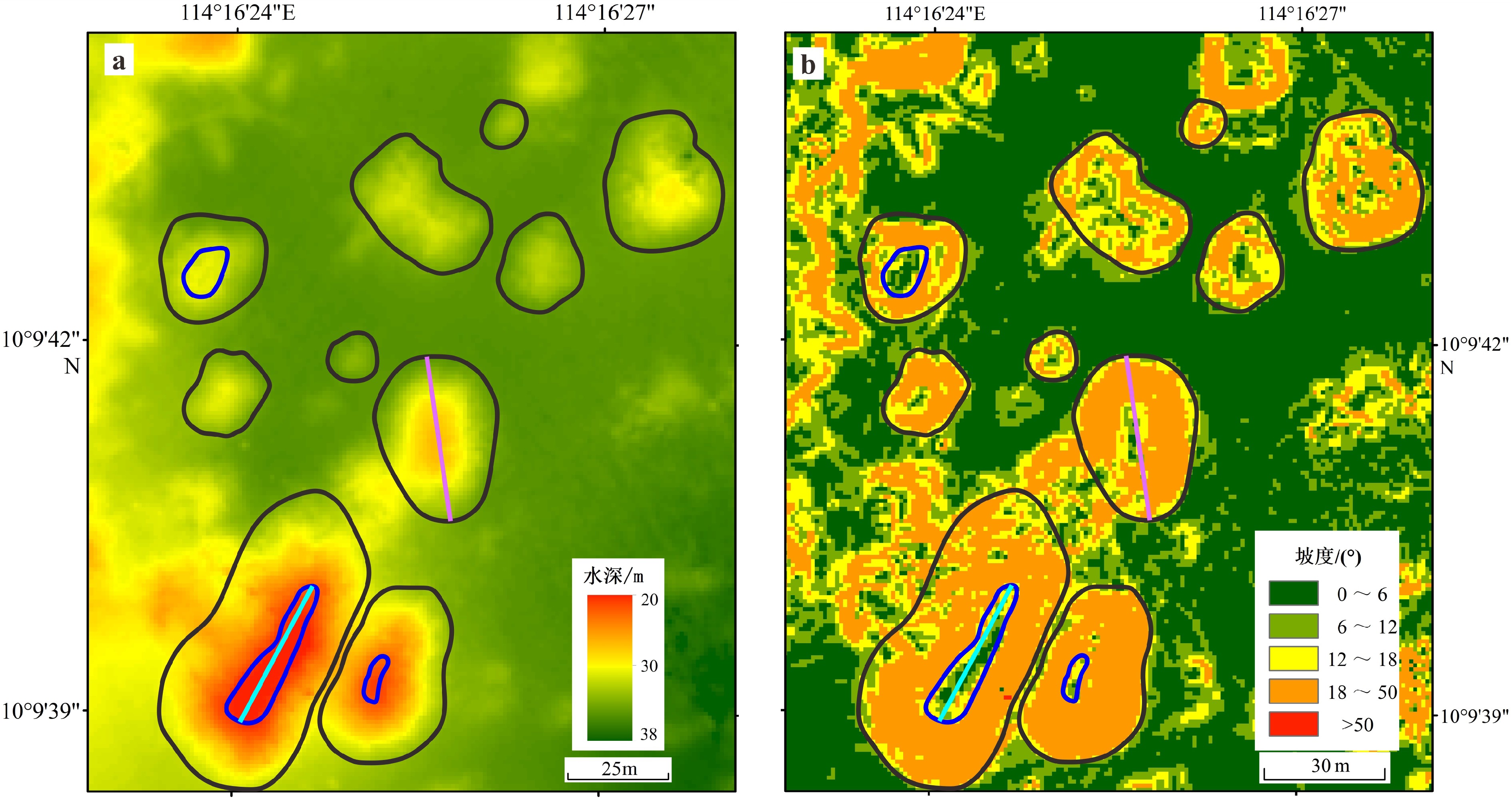
![]() 图 4 水深图(a)和坡度图(b)中的点礁位置见图3黑色方框1;黑色曲线表示点礁的外边界,蓝色曲线表示点礁的顶部,紫色线为其底部直径,青色线为其顶部直径。Figure 4. Patch reefs in bathymetric map (a) and gradient map (b)See black box 1, Fig.3 for location. Black lines are the outer boundaries of patch reefs, blue lines define the tops of the patch reef, purple lines define the basal diameters of patch reefs, while the cyan line shows the top diameters of patch reefs.
图 4 水深图(a)和坡度图(b)中的点礁位置见图3黑色方框1;黑色曲线表示点礁的外边界,蓝色曲线表示点礁的顶部,紫色线为其底部直径,青色线为其顶部直径。Figure 4. Patch reefs in bathymetric map (a) and gradient map (b)See black box 1, Fig.3 for location. Black lines are the outer boundaries of patch reefs, blue lines define the tops of the patch reef, purple lines define the basal diameters of patch reefs, while the cyan line shows the top diameters of patch reefs.点礁的形态参数统计结果见表2。123个点礁的底部直径范围为3.54~71.11 m,平均值为19.13 m,主要集中于5~20 m(60.2%)。顶部直径范围为1.31~50.06 m,平均值为8.49 m,主要集中于0~15 m(84.6%)。最高的点礁高达10.35 m,最小的仅0.30 m,平均高2.62 m,高度主要集中于1~3 m(61.8%)。点礁的最大底部深度为35.05 m,最小顶部深度为7.89 m,其中88个点礁分布于水深25~35 m(称其为深水点礁,占71.5%),其高和形状因子的平均值分别为2.74 m和0.16,顶部和底部直径的平均值分别为6.89 和17.44 m,顶底关系因子范围为0.13~0.77,平均值为0.39。27个分布于水深10~18 m(称其为浅水点礁,占17.9%),其高和形状因子的平均值分别为1.85 m和0.11,顶部和底部平均直径分别为11.79 和21.98 m,顶底关系因子为0.24~0.89,平均值为0.49。显然,与深水点礁相比,浅水点礁的顶部与底部平均直径和顶底关系因子均更大,平均高度和形状因子则相反。
表 2 小南薰礁的点礁地貌形态参数统计Table 2. Statistics of morphological parameters of patch reefs of Xiaonanxun Reef形态参数 平均值 最小值 最大值 点礁
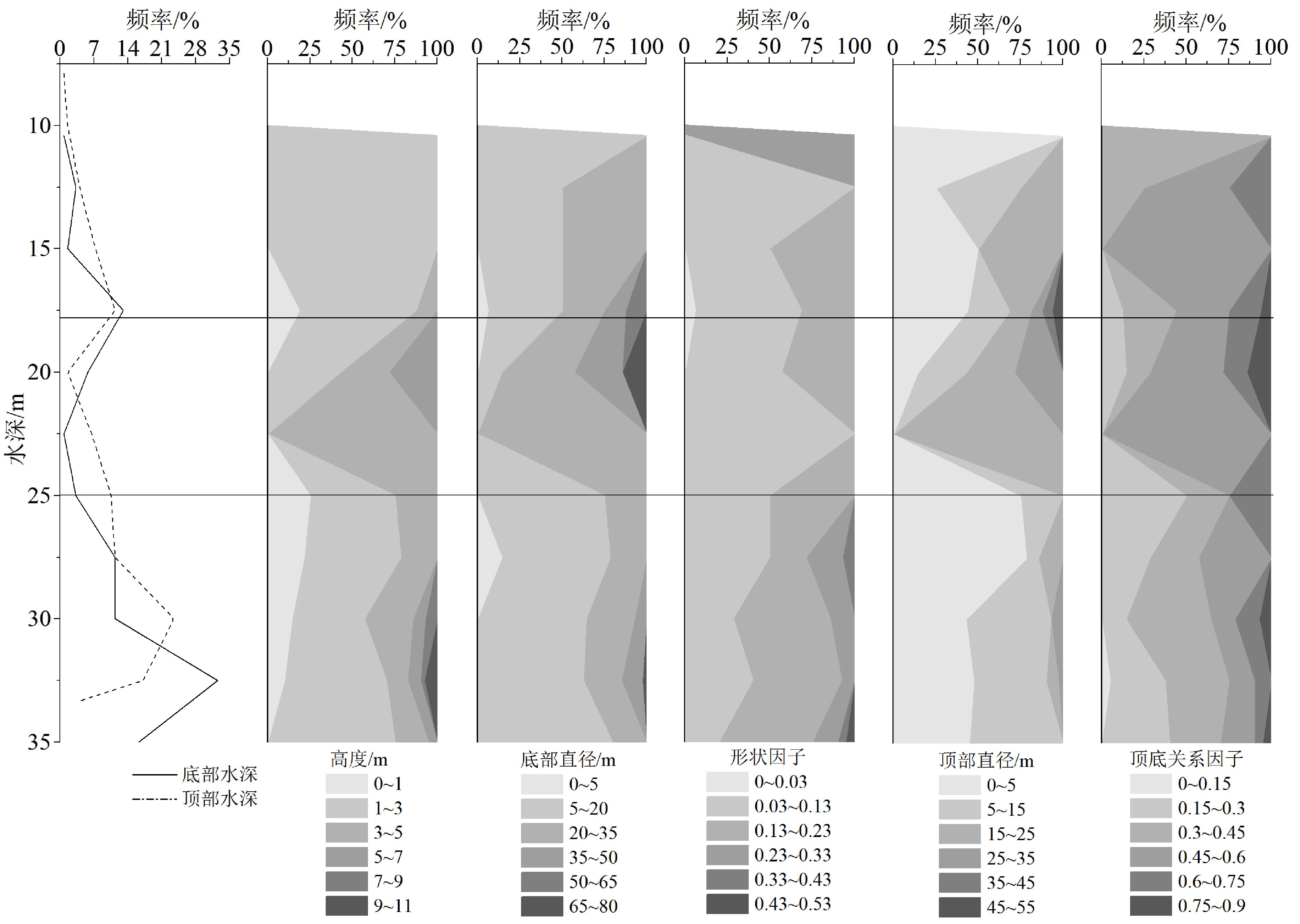
(123个)顶部深度H1/m 24.10 7.89 33.34 底部深度H2/m 26.71 10.42 35.05 高度H/m 2.62 0.30 10.35 底部直径D/m 19.13 3.54 71.11 形状因子H/D 0.15 0.03 0.47 顶部直径d/m 8.49 1.31 50.06 顶底关系因子d/D 0.42 0.13 0.89 深水点礁(88个) 顶部深度H1 /m 27.82 19.70 33.34 底部深度H2 /m 30.56 25.17 35.05 高度H/m 2.74 0.41 10.35 底部直径D/m 17.44 3.54 71.11 形状因子H/D 0.16 0.04 0.47 顶部直径d/m 6.89 1.31 29.83 顶底关系因子d/D 0.39 0.13 0.77 浅水点礁(27个) 顶部深度H1 /m 13.88 7.89 16.89 底部深度H2 /m 15.72 10.42 17.71 高度H/m 1.85 0.30 4.06 底部直径D/m 21.98 4.95 60.12 形状因子H/D 0.11 0.03 0.21 顶部直径d/m 11.79 2.26 50.06 顶底关系因子d/D 0.49 0.24 0.89 不同水深点礁的形态参数有所差异(图5),浅水点礁的高度均小于5 m,其形状因子均小于0.23,顶底关系因子较大,值为0.30~0.75的占87.0%,形状因子为0~0.03,且顶部直径大于35 m的点礁仅分布于浅水区。高于7 m的点礁均为深水点礁,其直径均大于40 m,分布在潮汐通道中。仅1个深水点礁底部直径超过70 m(表2),其余均小于50 m(图5),形状因子大于0.23的点礁仅发育于深水区。深水点礁的顶底关系因子主要为0.15~0.45(占67.4%),而此值为0~0.15的点礁仅发育于水深大于30 m海域,随水深增加顶底关系因子减小。综上,浅水点礁的高度和形状因子较小,直径和顶底关系因子较大,深水点礁则相反。底部水深为18~25 m的点礁数量虽然较少,但其顶部和底部直径都较大。
![]() 图 5 小南薰礁的点礁形态参数分布特点Figure 5. The distribution pattern of morphological parameters of Xiaonanxun Reef
图 5 小南薰礁的点礁形态参数分布特点Figure 5. The distribution pattern of morphological parameters of Xiaonanxun Reef3.2 小南薰礁的点礁地貌分类
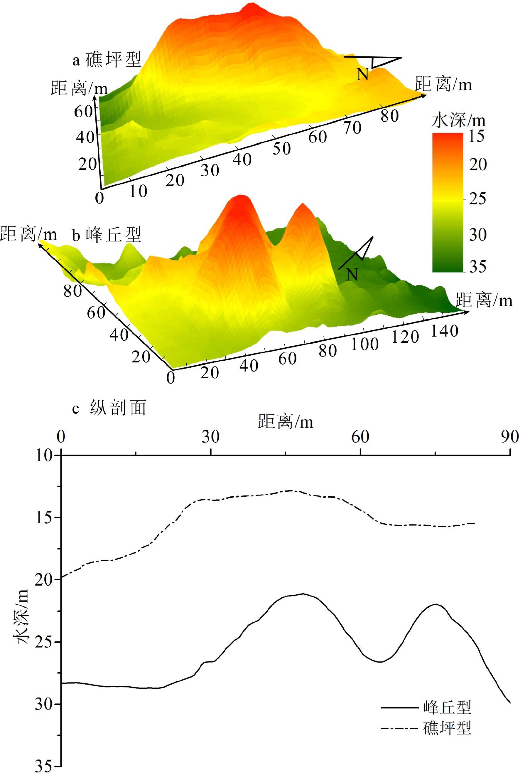
根据点礁底部深度的分布频率(图5),以形状因子和顶底关系因子为依据,可将小南薰礁的点礁划分为礁坪型和峰丘型两类(图6)。峰丘型点礁(图6b)的顶底关系因子较小,且顶部规模不大(形状因子>0.23,顶底关系因子<0.25),峰丘型点礁均发育在深水区(26个,21.1%),顶底关系因子小于0.40且高于3 m的点礁均为深水点礁。研究区以礁坪型点礁(图6a)为主(97个,78.9%),在深水区和浅水区都有发育,其形状因子相对较小,但顶部直径及顶底关系因子较大。典型的礁坪型点礁主要发育于浅水区,18~25 m的水深区仅发育8个点礁,其礁坪型特征显著,但形态参数随水深变化的组合特点与浅水点礁和深水点礁均有差异(图5)。
![]() 图 6 典型礁坪型点礁(a)和峰丘型点礁(b)及纵剖面(c)位置见图 3。Figure 6. Typical “pancake” (a) , “knoll” patch reef (b) and the profiles(c)See Fig.3 for locations.
图 6 典型礁坪型点礁(a)和峰丘型点礁(b)及纵剖面(c)位置见图 3。Figure 6. Typical “pancake” (a) , “knoll” patch reef (b) and the profiles(c)See Fig.3 for locations.按点礁的分布方式,可分为孤立型点礁和群落型点礁,其中,群落型点礁一般由3~10个规模相似的点礁构成,点礁之间的距离较小(<7.50 m)。研究区水深29~35 m海域发育有3处群落型点礁,分别由5、6和9个峰丘型点礁聚集而成,其余均为孤立型点礁,浅水点礁均为孤立分布的点礁。因此,据点礁的形态特点与分布方式,小南薰礁的点礁可以分为深水区的峰丘群落型点礁、峰丘孤立型点礁、礁坪孤立型点礁及浅水区的礁坪孤立型点礁4种类型。
4. 点礁地貌的控制因素
小南薰礁发育的点礁,其高度和底部直径显著相关(表3),指示其垂直方向和水平方向的发育具有协调一致性。深水点礁的相关性尤其显著(R=0.827),表明珊瑚礁以垂直方向上的生长建造为主,如峰丘型深水点礁。南部相邻的九章环礁水下暗礁中发育的珊瑚礁脊槽地貌,其脊长、脊宽和脊高三者之间亦呈正相关,也指示了珊瑚礁生长作用对脊槽地貌的控制[14]。对佛罗里达群岛点礁的研究表明,当生长空间充足时,珊瑚礁以垂向发育为主,形成峰丘型点礁,其底部直径和高度呈正相关[8]。
表 3 小南薰礁的点礁形态参数相关分析结果Table 3. Correlation of morphological parameters of patch reefs of Xiaonanxun Reef相关系数 顶部深度 底部深度 高度 底部直径D 形状因子 顶部直径d d/D 所有点礁 顶部深度 底部深度 0.960** 高度 −0.154 0.127 底部直径D −0.361** −0.165 0.697** 形状因子 0.163 0.264** 0.358** −0.254** 顶部直径d −0.444** −0.299** 0.519** 0.878** −0.239** d/D −0.330** −0.311** 0.070 0.186* 0.041 0.558** 深水点礁 顶部深度 底部深度 0.776** 高度 −0.603** 0.036 底部直径D −0.524** −0.002 0.827** 形状因子 0.190 0.072 0.392** −0.094 顶部直径d −0.535** −0.124 0.691** 0.844** −0.068 d/D −0.144 −0.167 0.017 −0.008 0.094 0.481** 浅水点礁 顶部深度 底部深度 0.824** 高度 −0.346 0.039 底部直径D −0.125 0.137 0.666** 形状因子 0.123 0.066 0.159 −0.669** 顶部直径d −0.153 0.090 0.620** 0.936** −0.549** d/D −0.270 −0.150 0.339 0.413* 0.041 0.644** 注:**在0.01水平(双侧)上显著相关,*在0.05水平(双侧)上显著相关。 点礁的底部深度与直径呈负相关,与形状因子呈正相关(表3),即直径随水深减小而增大,而形状因子随水深减小而减小。顶部直径与水深的相关性更为明显,可推测水深减小导致其所受波浪作用强度增大,点礁以横向生长为主,形成顶部直径和底部直径越大,而形状因子越小的特点。因此,峰丘型点礁仅发育于水深大于25 m区域,礁坪型特征随水深减小而更为显著,其中顶部水深在15 m左右的点礁,顶部更为宽广、平坦,是典型的礁坪型点礁,指示了小南薰礁地区常浪的波浪基面可能为15 m。这亦可能与全新世以来该海区海平面的上升过程有关,即海平面在这一深度曾停滞一段时间[16,34-37],小南薰礁水下暗礁14~17 m处相对平坦的地形,可能也在这一时期形成。当水深减小、珊瑚礁垂向建造的可容空间不足时,转为以横向扩张为主,发育成礁坪型点礁[4]。如发育于佛罗里达群岛[8]及大堡礁[6]水深较浅处的点礁,主要以礁坪型为主,充分体现了海平面对点礁横向生长的控制作用。
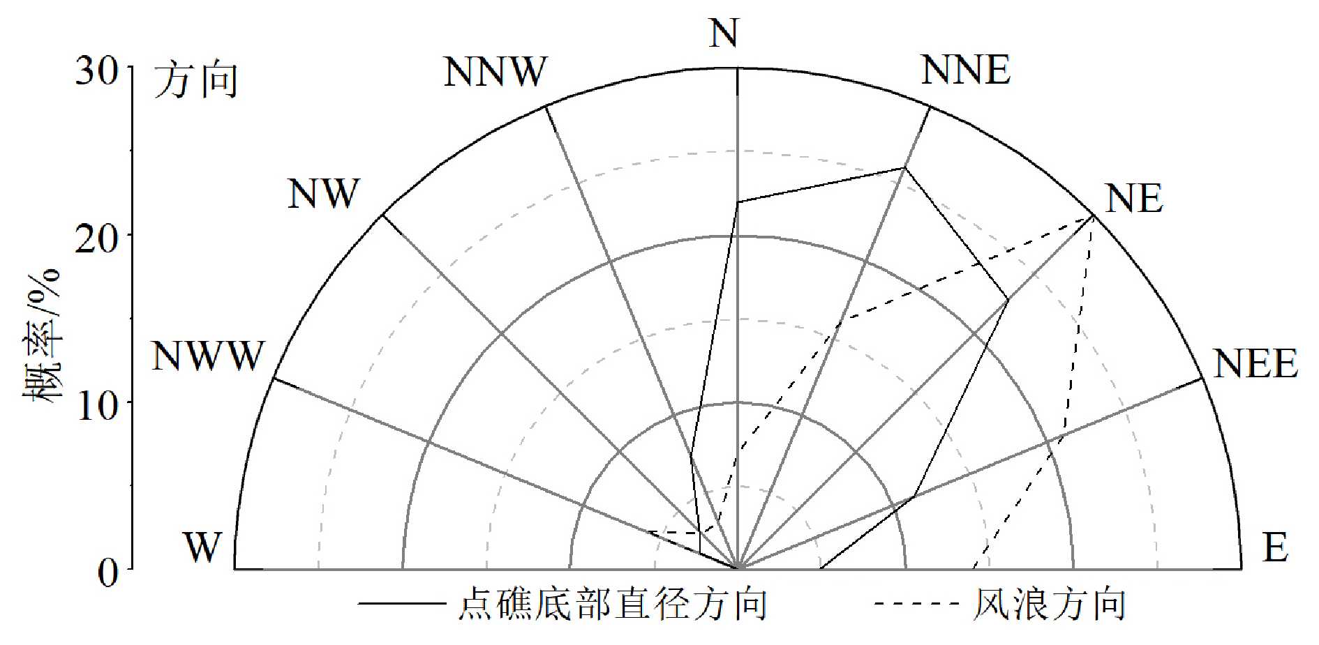
研究区点礁底部直径的延伸方向统计结果表明(图7),82.1%点礁底部直径呈NEE-N向延伸,这一方向与潮汐通道的延伸方向一致,与礁缘近似垂直,指示了浅水波波浪折射的影响,可能是在涨落潮流作用下浅水波与激浪的控制作用所致。据南沙北部永暑礁水文气象观测站1990—2008年的观测资料表明,此海区海水的运动方向与盛行风风向密切相关。每年11月至次年3月中旬,运动方向受东北风影响,5月下旬至9月则为西南风控制,其他时间为两个方向的过渡期[24]。在这种动力作用下,珊瑚礁的生长建造主要沿NE和SW两个方向延伸,故点礁底部直径的主要延伸方向与盛行风向(浪向)一致。这也影响了南沙群岛一系列环礁的整体延伸方向[38]。海水运动不仅影响点礁的剖面形态,而且对其排列方式和直径延伸方向也有影响,如加勒比海北部的点礁在持续的NW-SE向的风海流、洋流和潮流的控制下,点礁的直径亦主要呈NW-SE向延伸[11,39]。因此,点礁地貌特征受水深、海洋水动力及珊瑚礁生长建造过程的综合控制。
小南薰礁的浅水点礁均为孤立型点礁,而浅水点礁与脊槽发育的水深具有一致性,且脊槽延伸方向与点礁底部直径延伸方向也基本一致,这可能指示了点礁地貌与脊槽地貌的发育有一定关系。Peters等[10]认为佛罗里达群岛的点礁发育后期随着空间范围增大点礁之间距离缩小,点礁可能会连接形成脊槽地貌。研究区点礁水深为7.89~35.05 m,且浅水点礁均为礁坪型点礁,这与加勒比海区域在水深浅于2 m处发育点礁及礁坪型点礁主要出现在水深浅于7.7 m[8]相比,显然水深偏大,这可能与加勒比海珊瑚礁发育区水动力相对较弱[8-9]有关。小南薰礁的点礁与郑和环礁北部道明环礁的点礁地貌特征较相似,均以峰丘型和礁坪型为主,且呈孤立型和群落型分布[40],指示了南沙群岛北部环礁发育的现代点礁地貌的相似性。西沙群岛、南沙群岛的信义礁和海口礁等封闭型环礁[28]内点礁水深很浅,规模也较大,与小南薰礁发育的点礁差异较大,表明环礁发育程度与点礁的数量和规模相关[28]。因此,对于小南薰礁的点礁地貌的形成过程和机制,需进一步开展生物学、水动力学和沉积学等方面的研究。
5. 结论
(1)小南薰礁由干出礁和水下暗礁组成,点礁相对发育于水下暗礁的次成潟湖和潮汐通道中,其底部最大深度为35.05 m,顶部最小深度为7.89 m,高0.30~10.35 m,底部直径3.54~71.11 m,顶部直径1.31~50.06 m,形状因子为0.03~0.47,顶底关系因子为0.13~0.89,可分为峰丘型(形状因子>0.23,顶底关系因子<0.25)和礁坪型(顶部和底部直径较大),以礁坪型点礁为主(78.9%)。
(2)深水点礁和浅水点礁分别为88个(占71.5%)和27个(占17.9%),其中深水点礁呈礁坪型和峰丘型,以孤立型为主,出现群落型组合分布方式,顶底关系因子小于0.40且高于3 m的点礁均为深水点礁。浅水点礁为呈孤立分布的礁坪型点礁,其高度和形状因子较小,直径和顶底关系因子较大,礁坪型特点显著,深水点礁则相反,反映了点礁地貌形态在不同水深的分异。
(3)点礁的直径和高度呈正相关,深水点礁的相关性更为显著,相关系数达0.827,表明珊瑚礁以垂向生长为主,峰丘型点礁的发育突出显示了珊瑚礁生长建造作用对点礁地貌特征的控制。浅水点礁的礁坪型特点更为显著,反映了随着水深的减小,珊瑚礁生长建造过程中的横向发育增强的特点,表明水深和波浪作用对点礁地貌形态的控制。82.1%的点礁底部直径呈NEE-N向延伸,与盛行风风向(浪向)一致,表明点礁沿水动力较强的方向生长,使其底部直径延伸方向与海水运动的主要方向一致,反映了海水动力对点礁发育的控制。
致谢:本文多波束测深数据来自中国科学院学部咨询评议项目“南海海域、岛礁开发与海疆权益”与中国南海研究协同创新中心共同支持的2017年9月南京大学南海考察;华东师范大学博士生王黎和南京大学梁鹏硕士对多波束数据处理提供了指导;江苏第二师范大学夏非博士对论文的表达提出了建议;广西大学余克服教授对论文提出了有益的修改意见,谨致谢忱。
-
![]()
图 1 郑和环礁与小南薰礁的位置与地形
a为南海诸岛,据自然资源部标准地图<审图号:GS(2020)4617号>,图中黑色方框为b范围;b为郑和环礁,据Dong Y等[22]的水深、干出礁和暗礁的范围改绘。
Figure 1. Location and topography of Xiaonanxun Reef and Zhenghe Atoll in the Nansha Islands, South China Sea
a shows the islands in South China Sea, after the Standard Maps of Ministry of Natural Resources of the People’s Republic of China: GS(2020)4617.b shows the Zhenghe Atoll, modified from reference [22].The black box in a shows the location of b.
![]()
图 3 小南薰礁地貌类型和代表性点礁位置
图中黑色方框2为图4范围;蓝色方框1为图6a位置;绿色方框3为图6b位置;绿色和蓝色框中的白色直线为图6中两个剖面的位置。
Figure 3. Geomorphological classification and locations of the representative patch reefs of Xiaonanxun Reef
The black box 2 shows the location of Fig.4, the blue and green boxes show the locations of Fig.6a and 6b, the white lines inside of the green and blue boxes show the location of profiles in Fig.6.
![]()
图 4 水深图(a)和坡度图(b)中的点礁
位置见图3黑色方框1;黑色曲线表示点礁的外边界,蓝色曲线表示点礁的顶部,紫色线为其底部直径,青色线为其顶部直径。
Figure 4. Patch reefs in bathymetric map (a) and gradient map (b)
See black box 1, Fig.3 for location. Black lines are the outer boundaries of patch reefs, blue lines define the tops of the patch reef, purple lines define the basal diameters of patch reefs, while the cyan line shows the top diameters of patch reefs.
![]()
图 5 小南薰礁的点礁形态参数分布特点
Figure 5. The distribution pattern of morphological parameters of Xiaonanxun Reef
![]()
图 6 典型礁坪型点礁(a)和峰丘型点礁(b)及纵剖面(c)
位置见图 3。
Figure 6. Typical “pancake” (a) , “knoll” patch reef (b) and the profiles(c)
See Fig.3 for locations.
表 1 小南薰礁地貌形态特征及其典型影像
Table 1 Morphological characteristics of Xiaonanxun Reef and representative images
地貌名称 形态特征 面积/km2 所占比例/% 典型影像 干出礁 水深较浅、破浪带激浪作用活跃,造礁石珊瑚等生长较好,部分低潮时出露[18,28] 0.89 19.4 次成潟湖 礁坪上的低洼地,低潮不出露,以生物碎屑堆积为主[17,28] 0.45 9.8 潮汐通道 相对低洼、穿过礁坪的槽道,是潟湖与外海水体交换的通道,一般较少碎屑沉积,与“口门”相比,规模更小,水深更浅[17,29,33] 0.38 8.3 脊槽 线性的脊和槽相间组成,影像中绿色为脊部,一般为珊瑚聚集生长区;槽部为白色,一般为珊瑚贝壳碎屑堆积区[14,30,33] 0.89 19.4 珊瑚礁垄* 带状凸起区域,与脊槽相比,规模更大,主要由活珊瑚覆盖 1.98 43.1 注:*根据其形态特征,参照其他地貌名称进行定义。  下载: 导出CSV
表 2 小南薰礁的点礁地貌形态参数统计
Table 2 Statistics of morphological parameters of patch reefs of Xiaonanxun Reef
形态参数 平均值 最小值 最大值 点礁
(123个)顶部深度H1/m 24.10 7.89 33.34 底部深度H2/m 26.71 10.42 35.05 高度H/m 2.62 0.30 10.35 底部直径D/m 19.13 3.54 71.11 形状因子H/D 0.15 0.03 0.47 顶部直径d/m 8.49 1.31 50.06 顶底关系因子d/D 0.42 0.13 0.89 深水点礁(88个) 顶部深度H1 /m 27.82 19.70 33.34 底部深度H2 /m 30.56 25.17 35.05 高度H/m 2.74 0.41 10.35 底部直径D/m 17.44 3.54 71.11 形状因子H/D 0.16 0.04 0.47 顶部直径d/m 6.89 1.31 29.83 顶底关系因子d/D 0.39 0.13 0.77 浅水点礁(27个) 顶部深度H1 /m 13.88 7.89 16.89 底部深度H2 /m 15.72 10.42 17.71 高度H/m 1.85 0.30 4.06 底部直径D/m 21.98 4.95 60.12 形状因子H/D 0.11 0.03 0.21 顶部直径d/m 11.79 2.26 50.06 顶底关系因子d/D 0.49 0.24 0.89
下载: 导出CSV
表 3 小南薰礁的点礁形态参数相关分析结果
Table 3 Correlation of morphological parameters of patch reefs of Xiaonanxun Reef
相关系数 顶部深度 底部深度 高度 底部直径D 形状因子 顶部直径d d/D 所有点礁 顶部深度 底部深度 0.960** 高度 −0.154 0.127 底部直径D −0.361** −0.165 0.697** 形状因子 0.163 0.264** 0.358** −0.254** 顶部直径d −0.444** −0.299** 0.519** 0.878** −0.239** d/D −0.330** −0.311** 0.070 0.186* 0.041 0.558** 深水点礁 顶部深度 底部深度 0.776** 高度 −0.603** 0.036 底部直径D −0.524** −0.002 0.827** 形状因子 0.190 0.072 0.392** −0.094 顶部直径d −0.535** −0.124 0.691** 0.844** −0.068 d/D −0.144 −0.167 0.017 −0.008 0.094 0.481** 浅水点礁 顶部深度 底部深度 0.824** 高度 −0.346 0.039 底部直径D −0.125 0.137 0.666** 形状因子 0.123 0.066 0.159 −0.669** 顶部直径d −0.153 0.090 0.620** 0.936** −0.549** d/D −0.270 −0.150 0.339 0.413* 0.041 0.644** 注:**在0.01水平(双侧)上显著相关,*在0.05水平(双侧)上显著相关。
下载: 导出CSV
-
[1] Fairbridge R W. Recent and Pleistocene coral reefs of Australia [J]. The Journal of Geology, 1950, 58(4): 330-401. doi: 10.1086/625751
[2] 曾昭璇. 中国环礁的类型划分[J]. 海洋通报, 1982, 1(4):43-50 ZENG Zhaoxuan. Classfication of atolls in China [J]. Marine Science Bulletin, 1982, 1(4): 43-50.
[3] 海洋科技名词审定委员会. 海洋科技名词[M]. 2版. 北京: 科学出版社, 2007: 60 China National Marine Science and Technology Terminology Validation Committee. Chinese Terms in Marine Science and Technology[M]. 2nd ed. Beijing: Science Press, 2007: 60.
[4] Beaman R J, Webster J M, Wust R A J. New evidence for drowned shelf edge reefs in the Great Barrier Reef, Australia [J]. Marine Geology, 2008, 247(1-2): 17-34. doi: 10.1016/j.margeo.2007.08.001
[5] Harris P T, Davies P J. Submerged reefs and terraces on the shelf edge of the Great Barrier Reef, Australia [J]. Coral Reefs, 1989, 8(2): 87-98. doi: 10.1007/BF00301807
[6] Abbey E, Webster J M, Beaman R J. Geomorphology of submerged reefs on the shelf edge of the Great Barrier Reef: The influence of oscillating Pleistocene sea-levels [J]. Marine Geology, 2011, 288(1-4): 61-78. doi: 10.1016/j.margeo.2011.08.006
[7] 孙宗勋, 赵焕庭. 南沙群岛珊瑚礁动力地貌特征[J]. 热带海洋学报, 1996, 15(2):53-60 SUN Zongxun, ZHAO Huanting. Features of dynamic geomorphology of coral reefs in Nansha Islands [J]. Tropic Oceanology, 1996, 15(2): 53-60.
[8] Brock J C, Palaseanu-Lovejoy M, Wright C W, et al. Patch-reef morphology as a proxy for Holocene sea-level variability, Northern Florida Keys, USA [J]. Coral Reefs, 2008, 27(3): 555-568. doi: 10.1007/s00338-008-0370-y
[9] Brown B E, Dunne R P. Environmental controls of patch-reef growth and development [J]. Marine Biology, 1980, 56(1): 85-96. doi: 10.1007/BF00390598
[10] Peters M, Palandro D, Hallock P, et al. Assessing the distribution of patch reef morphologies in the Lower Florida Keys, USA, using IKONOS satellite imagery[C]//Proceedings of the 11th International Coral Reef Symposium. Lauderdale, 2008: 678-682.
[11] Jones J A. Morphology and development of southeastern Florida patch reefs[C]//Proceedings of the Third International Coral Reef Symposium, University of Miami. Miami, Florida, 1977: 232-235.
[12] Chu S S, Hong L, Cheng L, et al. Weighted multiscale region-level sparse representation for classification of high-spatial resolution remote sensing images [J]. Journal of Applied Remote Sensing, 2018, 12(4): 045005.
[13] Phinn S R, Hochberg E M, Roelfsema C M. Visible and infrared overview[M]//Goodman J A, Purkis S J, Phinn S R. Coral Reef Remote Sensing. Netherlands: Springer, 2013: 3-28.
[14] 王黎, 张永战. 九章环礁水下暗礁脊槽地貌分布与形态[J]. 第四纪研究, 2018, 38(2):485-495 doi: 10.11928/j.issn.1001-7410.2018.02.18 WANG Li, ZHANG Yongzhan. Distribution and morphological characteristics of spur and groove on submerged reefs of Jiuzhang Atoll, South China Sea [J]. Quaternary Sciences, 2018, 38(2): 485-495. doi: 10.11928/j.issn.1001-7410.2018.02.18
[15] Wang G Z. Tectonic and monsoonal controls on coral atolls in the South China Sea[M]//Camoin G F, Davies P J. Reefs and Carbonate Platforms in the Pacific and Indian Oceans. Blackwells: International Association of Sedimentologists, 1998, 25: 237-248.
[16] 王国忠. 全球海平面变化与中国珊瑚礁[J]. 古地理学报, 2005, 7(4):483-492 doi: 10.3969/j.issn.1671-1505.2005.04.006 WANG Guozhong. Global sea-level change and coral reefs of China [J]. Journal of Palaeogeography, 2005, 7(4): 483-492. doi: 10.3969/j.issn.1671-1505.2005.04.006
[17] 左秀玲, 苏奋振, 赵焕庭, 等. 南海珊瑚礁高分辨率遥感地貌分类体系研究[J]. 地理科学进展, 2018, 37(11):1463-1472 doi: 10.18306/dlkxjz.2018.11.003 ZUO Xiuling, SU Fenzhen, ZHAO Huanting, et al. Development of a geomorphic classification scheme for coral reefs in the South China Sea based on high-resolution satellite images [J]. Progress in Geography, 2018, 37(11): 1463-1472. doi: 10.18306/dlkxjz.2018.11.003
[18] 赵焕庭. 中国现代珊瑚礁研究[J]. 世界科技研究与发展, 1998, 20(4):98-105 ZHAO Huanting. Researches of coral reef in modern China [J]. World SCI-TECH R& D, 1998, 20(4): 98-105.
[19] Chang J H, Hsu H H, Liu C S, et al. Seismic sequence stratigraphic analysis of the carbonate platform, north offshore Taiping Island, Dangerous Grounds, South China Sea [J]. Tectonophysics, 2017, 702: 70-81. doi: 10.1016/j.tecto.2015.12.010
[20] 中国科学院南沙综合科学考察队. 南沙群岛自然地理[M]. 北京: 科学出版社, 1996: 46-48. Nansha Comprehensive Scientific Investigation Team, Chinese Academy of Sciences. Physical Geography of Nansha Islands[M]. Beijing, China: Science Press, 1996: 46-48.
[21] 胡心迪. 郑和环礁珊瑚礁地貌及其对海平面变化的响应[D]. 南京大学硕士学位论文, 2020: 19-26 HU Xindi. The geomorphology of Zhenghe Atoll and its response to sea level change[D]. Master Dissertation of Nanjing University, 2020: 19-26.
[22] Dong Y Z, Liu Y X, Hu C M, et al. Coral reef geomorphology of the Spratly Islands: A simple method based on time-series of Landsat-8 multi-band inundation maps [J]. ISPRS Journal of Photogrammetry and Remote Sensing, 2019, 157: 137-154. doi: 10.1016/j.isprsjprs.2019.09.011
[23] 赵焕庭, 宋朝景, 孙宗勋, 等. 南海诸岛全新世珊瑚礁演化的特征[J]. 第四纪研究, 1997(4):301-309 doi: 10.3321/j.issn:1001-7410.1997.04.003 ZHAO Huanting, SONG Zhaojing, SUN Zongxun, et al. The evolutionary characteristics of the Holocene coral reefs of the South China Sea Islands [J]. Quaternary Sciences, 1997(4): 301-309. doi: 10.3321/j.issn:1001-7410.1997.04.003
[24] 李文波, 赵军. 南沙海区波浪的季节变化特征[J]. 广东气象, 2010, 32(2):24-26 doi: 10.3969/j.issn.1007-6190.2010.02.009 LI Wenbo, ZHAO Jun. Seasonal variations of wave in Nansha [J]. Guangdong Meteorology, 2010, 32(2): 24-26. doi: 10.3969/j.issn.1007-6190.2010.02.009
[25] 王婷婷, 梁广建, 周兆黎, 等. 永暑海区波浪要素变化特征分析[J]. 海洋通报, 2012, 31(3):278-282 doi: 10.3969/j.issn.1001-6392.2012.03.006 WANG Tingting, LIANG Guangjian, ZHOU Zhaoli, et al. Analysis of the wave characteristics at Yongshu Reef [J]. Marine Science Bulletin, 2012, 31(3): 278-282. doi: 10.3969/j.issn.1001-6392.2012.03.006
[26] 余克服. 珊瑚记录之近50年南沙群岛高分辨率气候变化[D]. 中国科学院广州地球化学研究所博士学位论文, 2000: 9-16. YU Kefu. The recent fifty years high-resolution climate of Nansha Islands recorded in reef coral[D]. Doctor Dissertation of Guangzhou Institute of Geochemistry, Chinese Academy of Science, 2000: 9-16.
[27] 李维锋, 梁广健, 徐刚. 南沙永暑海区潮汐特征分析[J]. 海洋技术学报, 2014, 33(5):71-77 LI Weifeng, LIANG Guangjian, XU Gang. Analysis on the tide characteristics at the Yongshu Reef of the Nansha Islands [J]. Journal of Ocean Technology, 2014, 33(5): 71-77.
[28] 曾昭璇. 中国珊瑚礁地貌研究[M]. 广东: 广东人民出版社, 1997: 142-370. ZENG Zhaoxuan. Coral Reefs Geomorphic Research in China[M]. Guangzhou: Guangdong People’s Publishing House, 1997: 142-370.
[29] Kinzie I, Robert A. The zonation of West Indian gorgonians [J]. Bulletin of Marine Science, 1973, 23(1): 93-155.
[30] Xu J P, Li F, Zhao J H, et al. Geomorphic zones mapping and development status monitoring of coral reefs in Xisha, China[C]//2016 IEEE International Geoscience and Remote Sensing Symposium (IGARSS). Beijing: IEEE, 2016: 4588-4591.
[31] Mumby P J, Harborne A R. Development of a systematic classification scheme of marine habitats to facilitate regional management and mapping of Caribbean coral reefs [J]. Biological Conservation, 1999, 88(2): 155-163. doi: 10.1016/S0006-3207(98)00108-6
[32] 赵焕庭, 宋朝景, 朱袁智. 南沙群岛“危险地带”腹地珊瑚礁的地貌与现代沉积特征[J]. 第四纪研究, 1992(4):368-377 doi: 10.3321/j.issn:1001-7410.1992.04.009 ZHAO Huanting, SONG Zhaojing, ZHU Yuanzhi. Geomorphic and modern sedimentary features of coral reefs in the hinterland of "Dangerous Ground", Nansha Islands [J]. Quaternary Sciences, 1992(4): 368-377. doi: 10.3321/j.issn:1001-7410.1992.04.009
[33] Heap A, Harris P T. Geomorphology of the Australian margin and adjacent seafloor [J]. Australian Journal of Earth Sciences, 2008, 55(4): 555-585. doi: 10.1080/08120090801888669
[34] 赵焕庭, 孙宗勋, 宋朝景, 等. 南沙群岛永暑礁90多万年以来的海平面变化[J]. 海洋与湖沼, 1996, 27(3): 264-270 doi: 10.3321/j.issn:0029-814X.1996.03.006 ZHAO Huanting, SONG Zhaojing, SUN Zongxun, et al. The change of sea-level of Yongshu Reef in Nansha Islands since 900000 years B. P. [J]. Oceanologia et Limnologia Sinica, 1996, 27(3): 264-270. doi: 10.3321/j.issn:0029-814X.1996.03.006
[35] 聂宝符. 五千年来南海海平面变化的研究[J]. 第四纪研究, 1996(1):80-87 doi: 10.3321/j.issn:1001-7410.1996.01.009 NIE Baofu. Sea-level changes of the South China Sea in the past 5000 years [J]. Quaternary Sciences, 1996(1): 80-87. doi: 10.3321/j.issn:1001-7410.1996.01.009
[36] 时小军, 余克服, 陈特固, 等. 中—晚全新世高海平面的琼海珊瑚礁记录[J]. 海洋地质与第四纪地质, 2008, 28(5):1-9 SHI Xiaojun, YU Kefu, CHEN Tegu, et al. Mid-to Late-Holocene sea level highstands: Evidence from fringing coral reefs at Qionghai, Hainan Island [J]. Marine Geology & Quaternary Geology, 2008, 28(5): 1-9.
[37] 许淑梅, 吴鹏, 张威, 等. 南海关键地质历史时期的古海岸线变化[J]. 海洋地质与第四纪地质, 2013, 33(1):1-10 XU Shumei, WU Peng, ZHANG Wei, et al. Paleo-coastline changes in South China Sea in some critical times [J]. Marine Geology & Quaternary Geology, 2013, 33(1): 1-10.
[38] 曾昭璇. 南海环礁的若干地貌特征[J]. 海洋通报, 1984, 3(3):40-45 ZENG Zhaoxuan. Geomorphological features of atolls in the South China Sea [J]. Marine Science Bulletin, 1984, 3(3): 40-45.
[39] Marszalek D S, Babashoff G, Noel M R, et al. Reef distribution in south Florida[C]//Proceedings of the 3rd International Coral Reef Symposium. Miami, 1977: 223-229.
[40] 黄远静. 南沙郑和和道明环礁点礁地貌特征及其成因[D]. 南京大学硕士学位论文, 2021: 26-39. HUANG Yuanjing. Distribution and morphological characteristics of patch reefs at Xiaonanxun Reef, Zhenghe Atoll and Kuigui Sandbank, Daoming Atoll, South China Sea[D]. Master Dissertation of Nanjing University, 2021: 26-39.
-
期刊类型引用(1)
1. 王明壮,张喜洋,谭飞,王冠,施祺,杨红强. 南沙珊瑚礁潟湖坡微地貌对沉积物粒度特征的影响. 热带地理. 2024(10): 1826-1837 .  百度学术
百度学术
其他类型引用(0)


计量
- 文章访问数: 1469
- HTML全文浏览量: 356
- PDF下载量: 103
- 被引次数: 1