Characteristics and genetic dynamics of mud diapirs and mud volcanoes on the western slope of Okinawa Trough schematic geographic map of studied area mud diapirs with different morphology in multi-channel seismic section
-
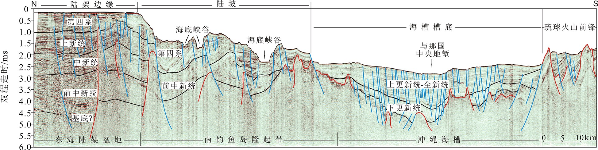
摘要: 海底泥底辟和泥火山对研究海底深部地球化学过程与全球碳循环、油气与天然气水合物资源勘查和新构造运动等具有重要的意义。利用高分辨率多道地震、浅地层剖面以及多波束等地球物理数据,对冲绳海槽西部陆坡泥底辟和泥火山的特征进行了分析和总结。冲绳海槽西部陆坡发育大量的泥底辟和泥火山,多发育于断裂活动强烈的区域,随着泥底辟的活动和甲烷流体的运移,在海底形成泥火山和气烟囱,因此,泥火山和气烟囱多发育于泥底辟上部,两翼存在强振幅异常,内部表现为低频特征,证明泥底辟和泥火山与甲烷流体活动存在密切联系。冲绳海槽西部陆坡泥火山和泥底辟的形成演化的动力学过程与成因主要包括3个方面,即区域拉张作用形成的构造薄弱带、快速沉积造成的超压和浮力作用以及流体的驱动作用。Abstract: Submarine mud diapirs and mud volcanoes are of great significance to the study of deep sea geochemical processes and global carbon cycle, the exploration of oil and gas hydrate resources and neotectonic activities. In this paper, the characteristics of mud diapir and mud volcanoes on the western slope of the Okinawa Trough are described and summarized with the geophysical data of high-resolution multi-channel seismic, sub-bottom profiling and multi-beam bathymetry survey. A large number of mud diapirs and mud volcanoes have been observed on the western slope of Okinawa Trough, mostly in the areas with strong fault activities. With the movement of mud diapirs and the migration of methane fluid, mud volcanoes and gas chimneys are commonly formed on the seafloor, mostly on the upper part of mud diapirs, with strong amplitude anomalies on the two wings and low frequency inside, which proves that the formation of mud diapirs and mud volcanoes are closely related to methane fluid activities. The dynamic evolution of mud volcanoes and mud diapirs on the western slope of the Okinawa Trough mainly includes three types: the weak structural zone formed by regional tension, the overpressure and buoyancy zone caused by rapid deposition, and the type formed by fluid driving.
-
Keywords:
- mud diapir /
- mud volcano /
- high resolution seismic /
- fluid migration /
- Okinawa Trough
-
天然气水合物是一种重要的战略能源和潜在未来能源,准确地探明中国的天然气水合物资源储量,有效地进行水合物资源的勘探开发,具有非常重要的战略意义、环境意义和经济意义。地震勘探是天然气水合物识别和预测的重要手段之一。地震资料上似海底反射层(BSR)、振幅空白带以及极性反转等地震反射特征[1-2],通常作为海域水合物储层的重要识别标志。地震反射主要是由储层波阻抗差异引起的,但在特定条件下岩性变化或者不整合面等原因也可能造成波阻抗差异,引起类似的地震响应。地震剖面上BSR常见于海域斜坡或者浅部海底沉积地层上,但在一些发现水合物的区域,并未表现出明显的BSR特征[3],如墨西哥湾、中国南海北部陆坡西部区域等,而且不同类型水合物储层的BSR特征也有较大差异[4-5]。BSR等地震反射特征与水合物地层并非一一对应关系,仅依靠地震反射特征难以准确识别天然气水合物[6],这对海域水合物储层的地震识别和预测提出了更高的要求。
天然气水合物的微观赋存形态是影响其储层特性的主要因素[7-8]。为提高水合物识别和预测的可靠性,一个重要的途径是从地震数据中准确提取天然气水合物地层的物性信息,为此需要解决两个关键问题:第一个问题是如何建立储层宏观弹性特征(包括体积模量、剪切模量、纵波速度、横波速度、密度等)与天然气水合物微观结构之间的定量关系。岩石物理建模是建立该定量关系的重要手段,目前应用较多的岩石物理模型包括适用于固结海洋沉积物的胶结模型[9-10]和等效介质模型[11-12]以及适用于未固结海洋沉积物的接触理论[13-15]等。这些岩石物理模型各自具有不同的假设条件和适用条件。水合物的微观赋存形态会因沉积环境的不同而显著变化,实验研究表明,水合物的存在会增强地层的剪切强度[16]。考虑水合物微观赋存形态及剪切性质的岩石物理型有待进一步研究。
第二个问题是如何建立水合物储层地震信息(包括振幅、相位、频率等动力学特征以及BSR、振幅空白带等地球物理响应)与弹性参数之间定量关系。地震反演方法是天然气水合物探测的有效技术手段之一。弹性阻抗反演[17-23]、AVO(Amplitude variation with offset,振幅随偏移距的变化)及AVA(Amplitude variation with angle,振幅随入射角度的变化)反演方法[24-26]以及全波形反演[27-28]等地震反演方法已在天然气水合物探测中取得了成功应用。然而,天然气水合物地层的宏观和微观结构高度复杂、非均质性强,成藏模式随不同区域而变化,基于地震数据进行水合物地层物性信息的定量反演仍存在一定的多解性[29-30],这对水合物的定量解释和勘探提出了挑战。目前流体识别的叠前地震反演方法日趋完善,并在多个地区取得了较好的应用效果[31],而水合物地层的微观赋存形态以及宏观沉积环境区别于常规含流体储层,因此此类反演方法在水合物地层的应用还有待进一步研究。
针对第一个问题,本文根据海域天然气水合物的微观结构特征,在岩石物理建模的框架下,考虑水合物非零剪切模量的特征,使用基于非耦合微分有效介质(DEM)理论和斑块饱和理论进行岩石物理建模,计算水合物地层物性参数与弹性参数的定量关系;针对第二个问题,在岩石物理分析的基础上,使用叠前贝叶斯地震反演方法,从叠前地震数据中提取水合物地层的剪切模量参数。实际应用结果表明,剪切模量对水合物含量有较好的指示性。本文的方法对水合物储层的识别提供了方法和技术支撑,对后续水合物物性参数定量反演提供新的思路。
1. 工区概况
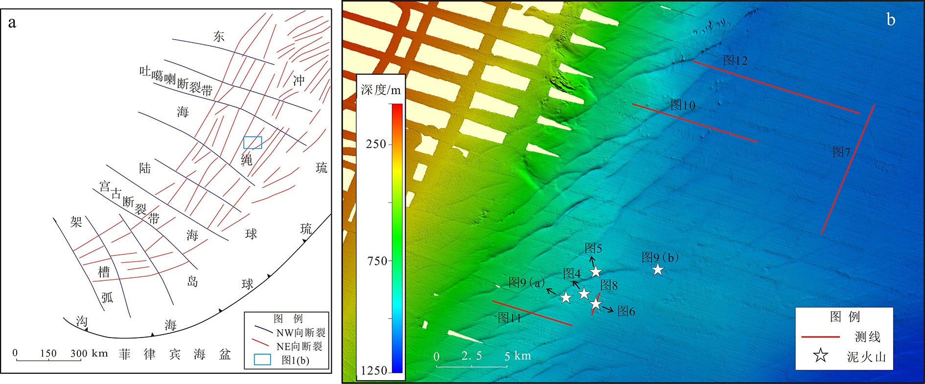
神狐海域位于南海北部陆坡神狐暗沙东南海域附近(图1),水合物钻探区水深为1 000~1 500 m,新生代沉积厚度达1 000~7 000 m,具有扩散型天然气水合物的成藏系统。适宜的温压条件、丰富的气源供给,加之底辟构造、高角度断裂和垂向裂隙系统等有利的运移通道,为水合物发育创造了良好的条件[32]。2006年,广州海洋地质调查局在此区域实施了三维地震采集,2007年完成了中国首次天然气水合物钻探,成功获取了天然气水合物的实物样品。
![]() 图 1 研究区位置图a:神狐海域研究区构造(红色方块) ,b:研究区内水合物钻探站位分布Figure 1. The location of the study areaa: The tectonic map of the Shenhu area (red square), b: the distribution of hydrate drilling stations in the red square (enlarged)
图 1 研究区位置图a:神狐海域研究区构造(红色方块) ,b:研究区内水合物钻探站位分布Figure 1. The location of the study areaa: The tectonic map of the Shenhu area (red square), b: the distribution of hydrate drilling stations in the red square (enlarged)神狐海域水合物稳定带受到周围温压条件限制,含水合物沉积层基本上位于海底以下135~230 m,分布于强振幅BSR的上覆沉积地层中[33],大部分BSR与地层斜交,波形极性与海底同相轴极性相反,且上部发育弱振幅或者振幅空白带[34](图2)。横向上BSR反射振幅及垂向上BSR厚度均存在一定变化,主要是由于地层的孔隙度、渗透率等物性差异导致水合物饱和度不同而造成的。
2. 弹性参数计算
针对前述的第一个问题,本文采用岩石物理建模的方法,建立地层宏观弹性参数与天然气水合物微观结构之间的定量关系。陆红锋等[35]对岩芯进行了X射线衍射成分分析,指出神狐海域沉积物组分以碎屑矿物、黏土矿物和碳酸盐矿物为主,并给出了各组分的含量,据此假设岩石基质由方解石、石英、黏土等组成。水合物含量主要受地层岩性、孔隙的微观结构及表面性质的影响[8],神狐海域水合物主要分散状分布于矿物颗粒的孔隙中[36-37],由于南海沉积物中存在大量有孔虫壳体,水合物主要占据有孔虫壳体内部空间并堵塞了孔隙间的连通喉道,显著降低了沉积物的气、水渗透能力[38];研究还发现,黏土含量的增加会导致被黏土颗粒束缚的孔隙水含量也随之增加[39]。据此考虑孔隙几何形状和连通性,假设地层中孔隙空间包含不连通的束缚水孔隙以及连通的硬币状孔隙和椭球形孔隙,其中硬币状孔隙纵横比较小,受到压力易趋向于闭合,连通性较差,而椭球形孔隙纵横比较大,连通性较好。孔隙空间中可能存在水合物、游离气和水共存的情况[40],该地区的水合物呈现出典型的I型结构,甲烷气体的含量超过99.3%[41],据此,结合前人对水合物微观结构的研究结果(图3a、b),将水合物地层等效为图3c所示的等效介质。
![]() 图 3 实验室获取的水合物CT图像[42]及水合物等效介质模型a:原始图像,b:对a图红色框线内区域进行灰度分析、着色后放大图,c:等效介质模型。Figure 3. CT images of gas hydrate obtained in laboratory and equivalent medium model of gas hydrate-bearing sedimentsa: Original image, b: enlarged image of the area in the red frame after grey analysis and coloring, c: equivalent medium model of gas hydrate-bearing sediments.
图 3 实验室获取的水合物CT图像[42]及水合物等效介质模型a:原始图像,b:对a图红色框线内区域进行灰度分析、着色后放大图,c:等效介质模型。Figure 3. CT images of gas hydrate obtained in laboratory and equivalent medium model of gas hydrate-bearing sedimentsa: Original image, b: enlarged image of the area in the red frame after grey analysis and coloring, c: equivalent medium model of gas hydrate-bearing sediments.在地震岩石物理建模的理论框架下建立天然气水合物地层的岩石物理模型(主要流程见图4):
①利用Hashin-Shtrikman-Walpole界限[43]将矿物组分混合形成颗粒基质。
②在基质中加入充填束缚水的不连通孔隙,作为新的基质。束缚水孔隙纵横比假设为0.1。根据Kuster-Toksöz模型计算基质中加入束缚水孔隙之后的弹性参数:
$$\begin{split}& \left( {{\boldsymbol{K}} - {{\boldsymbol{K}}_{gr}}} \right){\left( {{\boldsymbol{K}} + 4{{{{\boldsymbol{R}}_{gr}}} \mathord{\left/ {\vphantom {{{{\boldsymbol{R}}_{gr}}} 3}} \right. } 3}} \right)^{ - 1}}\left( {{{\boldsymbol{K}}_{gr}}+ 4{{{{\boldsymbol{R}}_{gr}}} \mathord{\left/ {\vphantom {{{{\boldsymbol{R}}_{gr}}} 3}} \right. } 3}} \right) = \\&\quad{\phi _{wc}}\left( {{{\boldsymbol{K}}_w} - {{\boldsymbol{K}}_{gr}}} \right){{\boldsymbol{P}}^{wc}} \end{split}$$ (1) 其中,${\boldsymbol{K}} = (K,\mu )$,$ K $、$ \mu $分别为基质中加入束缚水孔隙之后的体积模量和剪切模量;${{\boldsymbol{K}}_{{\text{gr}}}} = ({K_{{\text{gr}}}},{\mu _{{\text{gr}}}})$,${{\boldsymbol{K}}_{\text{w}}} = ({K_{\text{w}}},{\mu _{\text{w}}})$分别为岩石基质和水的弹性模量;$ {\phi _{{\text{wc}}}} $为束缚水孔隙的孔隙度,${\boldsymbol{R}} = \left( {\mu ,\dfrac{\mu }{8}\dfrac{{9K + 8\mu }}{{K + 2\mu }}} \right)$;系数${{\boldsymbol{P}}^{{\text{wc}}}} = ({P^{{\text{wc}}}},{Q^{{\text{wc}}}})$是几何因子,由孔隙纵横比确定。
③利用非耦合DEM模型[44]向②得到的基质中加入干燥的硬币状孔隙和椭球形孔隙,形成干燥骨架:
$$ K_{\text{d}}^{}\left( \phi \right){\text{ = }}{K_1}{(1 - \phi )^{\left( {{P^0} + {P^1}} \right)}}{e^{{P^1}\phi }} $$ (2) $$ \mu _{\text{d}}^{}\left( \phi \right){\text{ = }}{\mu _1}{(1 - \phi )^{\left( {{Q^0} + {Q^1}} \right)}}{e^{{Q^1}\phi }} $$ (3) 其中,$K_{\text{d}}^{}$和$\mu _{\text{d}}^{}$分别是干燥骨架的体积模量和剪切模量;${P^0} = \dfrac{{{A_1}}}{{{A_4}}}$,${P^1} = \dfrac{{{A_2}{A_4} - {A_1}{A_5}}}{{A_4^2}}$,${Q^0} = \dfrac{{{C_1}}}{{{C_4}}} + \dfrac{{{D_1}}}{{{D_4}}}$,${Q^1} = \dfrac{{{C_2}{C_4} - {C_1}{C_5}}}{{C_4^2}} + \dfrac{{{D_2}{D_4} - {D_1}{D_5}}}{{D_4^2}}$,$ A_1,A_2.\ldots A_5 $,$ C_1,C_2.\ldots C_5 $和$ D_1,D_2.\ldots D_5 $等是与固体基质和孔隙纵横比有关的参数,具体表达式见文献[44]。根据Xu和White(1995)的岩石物理建模思想[45],假设硬币状孔隙的孔隙度与黏土体积含量成正比,其余的孔隙为椭球形孔隙。
④利用广义Gassmann方程[46]将水合物填充到硬币状孔隙中,形成水合物斑块:
$$ K_{\text{s}}^{ - 1} = K_{\text{d}}^{ - 1} - {\left( {K_{\text{d}}^{ - 1} - K_{\text{m}}^{ - 1}} \right)^2}{\left[ {\phi \left( {K_{if}^{ - 1} - K_\phi ^{ - 1}} \right) + \left( {K_{\text{d}}^{ - 1} - K_{\text{m}}^{ - 1}} \right)} \right]^{ - 1}} $$ (4) $$ \mu _{\text{s}}^{ - 1} = \mu _{\text{d}}^{ - 1} - {\left( {\mu _{\text{d}}^{ - 1} - \mu _{\text{m}}^{ - 1}} \right)^2}{\left[ {\phi \left( {\mu _{if}^{ - 1} - \mu _\phi ^{ - 1}} \right) + \left( {\mu _{\text{d}}^{ - 1} - \mu _{\text{m}}^{ - 1}} \right)} \right]^{ - 1}} $$ (5) 其中,$ {\mu _{\text{s}}} $是水合物充填斑块的剪切模量,$ {K_\phi } $和$ {\mu _\phi } $分别是与孔隙相关的体积模量和剪切模量,$ {K_{if}} $和$ {\mu _{if}} $分别是第$i$种孔隙充填物的体积和剪切模量。利用广义Gassmann方程可以得到固体(如有机质、水合物等)充填于孔隙情况下的饱和岩石的弹性模量。
利用Gassmann方程将水/气填充到椭球形孔隙中,形成水/气斑块;最后,利用斑块饱和模型[47]和Reuss平均[48]将水合物斑块和水/气斑块混合,形成饱和岩石:
$$ {K_{\text{R}}} = {\left\langle {{{\left( {K + 4{\mu \mathord{\left/ {\vphantom {\mu 3}} \right. } 3}} \right)}^{ - 1}}} \right\rangle ^{ - 1}} - 4{\mu \mathord{\left/ {\vphantom {\mu 3}} \right. } 3} $$ (6) $$ {\mu _{\text{R}}} = {\left( {\sum\limits_{i = 1}^N {{{{f_i}} \mathord{\left/ {\vphantom {{{f_i}} {{\mu _i}}}} \right. } {{\mu _i}}}} } \right)^{ - 1}} $$ (7) 其中,$ {K_{\text{R}}} $和${\mu _{\text{R}}}$分别表示饱和沉积物的等效体积和剪切模量;${f_i}$为其体积含量;$ \left\langle \cdot \right\rangle $表示对每个斑块按体积含量进行加权平均;$ {\mu _i} $为第$ i $个斑块的剪切模量。
根据上述岩石物理模型计算水合物地层的弹性参数。假设地层的矿物组分为石英和黏土,孔隙度为35%,硬币状和椭球形孔隙的纵横比分别假设为0.04和0.35,孔隙中充填水合物和水,选取的其余弹性常数如表1所示。剪切模量和纵波速度随水合物剪切模量的变化如图5所示,两者都随水合物剪切模量的增大而增大,水合物饱和度越高,地层剪切模量随水合物剪切模量的变化越大。
表 1 数值计算所选用的弹性常数Table 1. The elastic constants used for numerical calculation组分 体积模量/GPa 剪切模量/GPa 密度/(g/cm3) 来源 石英 37.0 44.0 2.65 Carmichale, 1989 黏土 21.0 7.0 2.60 Tosaya and Nur, 1982 水合物 7.7 3.2 0.91 Waite et al, 2000 水 2.25 1000 ![]() 图 5 水合物地层纵波速度(a)和剪切模量(b)随水合物剪切模量的变化Figure 5. P-wave velocity (a) and shear modulus (b) of gas hydrate-bearing sediments versus shear modulus of gas hydrate component
图 5 水合物地层纵波速度(a)和剪切模量(b)随水合物剪切模量的变化Figure 5. P-wave velocity (a) and shear modulus (b) of gas hydrate-bearing sediments versus shear modulus of gas hydrate component使用下式计算弹性参数对水合物含量的敏感性评价指标:
$$ {D_{{S_i}}} = \left| {\frac{{{P_{{S_i}}} - {P_{{S_0}}}}}{{{P_{{S_0}}}}}} \right| $$ (8) 其中,${D_{{S_i}}}$和${P_{{s_i}}}$分别表示水合物饱和度为${S_i}$时的敏感性评价指标和弹性参数;${P_{{s_0}}}$表示地层不含水合物时的弹性参数。计算不同弹性参数对水合物含量的敏感性评价指标(图6)发现,纵波速度、横波速度、泊松比、体积模量和剪切模量等弹性参数对水合物含量都有一定的敏感性,但是泊松比的敏感性较低,纵波速度和横波速度对水合物含量的敏感性相当,剪切模量对水合物含量的敏感性最高。这与数值计算的结论是一致的,也证明了使用剪切模量参数来识别水合物的可行性。
![]() 图 6 不同弹性参数的敏感性评价指标Figure 6. Sensitivity indicator for hydrate content of different elastic parameters
图 6 不同弹性参数的敏感性评价指标Figure 6. Sensitivity indicator for hydrate content of different elastic parameters2007年在神狐海域共实施了8个天然气水合物钻探站位,其中SH2、SH3和SH7站位钻遇了水合物样品。其中SH2站位水合物厚度约25 m,位于海底以下195~220 m,平均饱和度25%[49],最高值达48%,部分测井曲线如图7所示。
![]() 图 7 SH2站位测井曲线绿色层段表示水合物地层。Figure 7. Well logging data of SH2 siteThe green section represents hydrate-bearing sediments.
图 7 SH2站位测井曲线绿色层段表示水合物地层。Figure 7. Well logging data of SH2 siteThe green section represents hydrate-bearing sediments.针对本研究区内的SH2站位,使用上述建模方法计算站位处的弹性参数。硬币状孔隙和椭球形孔隙各自的纵横比根据实测纵波速度反演求得。计算得到的纵横波速度以及剪切模量如图8所示。计算的纵波速度和与实测纵波速度有较好的一致性,两者相关系数为0.824,方差为
0.0182 ,绝对误差平均值为48.49 m/s。对计算得到的弹性参数进行交会分析(图9),实测纵波速度和自然伽马对水合物含量的区分能力有限,而剪切模量对于水合物含量有较好的指示作用,较高水合物饱和度的地层对应着较高的剪切模量。![]() 图 8 SH2站位水合物地层的水合物饱和度及弹性参数计算结果a:根据实测电阻率曲线计算的水合物饱和度,b:纵波速度(红色曲线表示实测值,黑色曲线表示计算值),c:横波速度计算值;d:剪切模量计算值。Figure 8. Calculation results of hydrate saturation and elastic parameters of hydrate strata at SH2 sitea: hydrate saturation calculated according to the measured resistivity, b: P-wave velocity (red curve represents the measured value, black curve represents the calculated value), c: calculated shear wave velocity; d: calculated shear modulus.
图 8 SH2站位水合物地层的水合物饱和度及弹性参数计算结果a:根据实测电阻率曲线计算的水合物饱和度,b:纵波速度(红色曲线表示实测值,黑色曲线表示计算值),c:横波速度计算值;d:剪切模量计算值。Figure 8. Calculation results of hydrate saturation and elastic parameters of hydrate strata at SH2 sitea: hydrate saturation calculated according to the measured resistivity, b: P-wave velocity (red curve represents the measured value, black curve represents the calculated value), c: calculated shear wave velocity; d: calculated shear modulus.![]() 图 9 SH2站位水合物地层弹性参数交会图a:实测纵波速度和实测自然伽马交会图,b:计算的体积模量和剪切模量交会图。Figure 9. Crossplots of elastic parameters of hydrate-bearing sediments at SH2 sitea: Crossplot of measured P-wave velocity and measured Gamma, b: crossplot of calculated bulk modulus and shear modulus.
图 9 SH2站位水合物地层弹性参数交会图a:实测纵波速度和实测自然伽马交会图,b:计算的体积模量和剪切模量交会图。Figure 9. Crossplots of elastic parameters of hydrate-bearing sediments at SH2 sitea: Crossplot of measured P-wave velocity and measured Gamma, b: crossplot of calculated bulk modulus and shear modulus.3. 叠前地震反演
关于纵波模量和剪切模量的弹性阻抗方程,其标准化形式为[50]:
$$ {\text{EI}}(\theta ) = {({M_0}{\rho _0})^{\frac{1}{2}}}{\left( {\frac{M}{{{M_0}}}} \right)^{a(\theta )}}{\left( {\frac{\mu }{{{\mu _0}}}} \right)^{b(\theta )}}{\left( {\frac{\rho }{{{\rho _0}}}} \right)^{c(\theta )}} $$ (9) 其中,$ {\text{EI}} $为弹性阻抗,$ M $和$ \mu $分别为饱和岩石的纵波模量和剪切模量(横波模量),$a = \frac{1}{2}{\sec ^2}\theta $,$ b = - 4\gamma _{}^2{\sin ^2}\theta $,$c = 1 - \frac{1}{2}{\sec ^2}\theta $,$\theta $为入射角。
结合岩石物理框架下弹性参数的计算结果,从测井资料以及地震资料出发,利用弹性阻抗贝叶斯反演方法计算得到弹性阻抗,然后使用上式进行纵横波模量的直接提取。该方法不需要先提取纵横波速度及密度信息,因此避免了从弹性阻抗计算纵横波速度再计算剪切模量过程中的累积误差。
弹性阻抗贝叶斯反演得到的弹性阻抗体以及直接反演得到的水合物地层剪切模量如图10所示。反演结果整体横向连续性较好,水合物地层分属高剪切模量数值区间,与岩石物理交会分析的认识相吻合;测井纵波速度增大的位置与剪切模量较高的位置匹配较好,反演结果与SH2井的实际测井钻遇结果保持较高一致性,验证了本工区使用剪切模量直接反演方法进行水合物识别的可靠性。
![]() 图 10 SH2站位水合物地层弹性参数交会图蓝色曲线为SH2井的实测纵波速度曲线。a:中角度叠加地震剖面,中心角度为20°;b:中角度弹性阻抗剖面,中心角度为20°;c:反演得到的剪切模量剖面。Figure 10. Seismic, elastic impedance, and inverted shear modulus profiles of SH2 siteThe blue curve is the measured P-wave velocity of SH2 site. a: Partial stack seismic profile at centric angle of 20°; b: elastic impedance profile at centric angle of 20°; c: inverted shear modulus profile.
图 10 SH2站位水合物地层弹性参数交会图蓝色曲线为SH2井的实测纵波速度曲线。a:中角度叠加地震剖面,中心角度为20°;b:中角度弹性阻抗剖面,中心角度为20°;c:反演得到的剪切模量剖面。Figure 10. Seismic, elastic impedance, and inverted shear modulus profiles of SH2 siteThe blue curve is the measured P-wave velocity of SH2 site. a: Partial stack seismic profile at centric angle of 20°; b: elastic impedance profile at centric angle of 20°; c: inverted shear modulus profile.4. 结论
(1)考虑神狐海域天然气水合物的微观结构特征,基于测井数据和地震数据,使用岩石物理建模以及叠前贝叶斯地震反演方法,从叠前地震数据中提取水合物地层的剪切模量参数,与SH2站位测井钻遇结果保持较高一致性,验证了使用剪切模量反演方法进行水合物识别的可靠性和有效性。
(2)在岩石物理建模过程中,对于水合物地层的微观结构,本文主要是通过矿物组分、孔隙结构以及水合物和矿物颗粒的接触关系来描述。实际水合物地层的微观结构随沉积环境以及富集条件的变化而差别非常大,因此等效岩石物理模型所用的一些物性参数,比如孔隙形状以及各类孔隙的孔隙度,都是对实际地层微观结构的等效近似。针对水合物地层的矿物组分以及水合物在地层中的赋存状态,许多学者通过CT图像以及实验等途径,给出了具体的描述和大量的数据,这些都是本文进行岩石物理建模的依据。
(3)本文的方法适用于孔隙充填型水合物地层,为该类水合物地层的识别和预测提供了一种新的思路和可靠的方法。但是海域水合物的赋存状态多样,包括颗粒支撑型、裂缝充填型等,不同类型的水合物需要通过岩石物理建模和交会分析等方法查明弹性参数对水合物含量的敏感性,确定敏感弹性参数,再使用地震反演方法进行敏感弹性参数的提取。
-
![]()
![]()
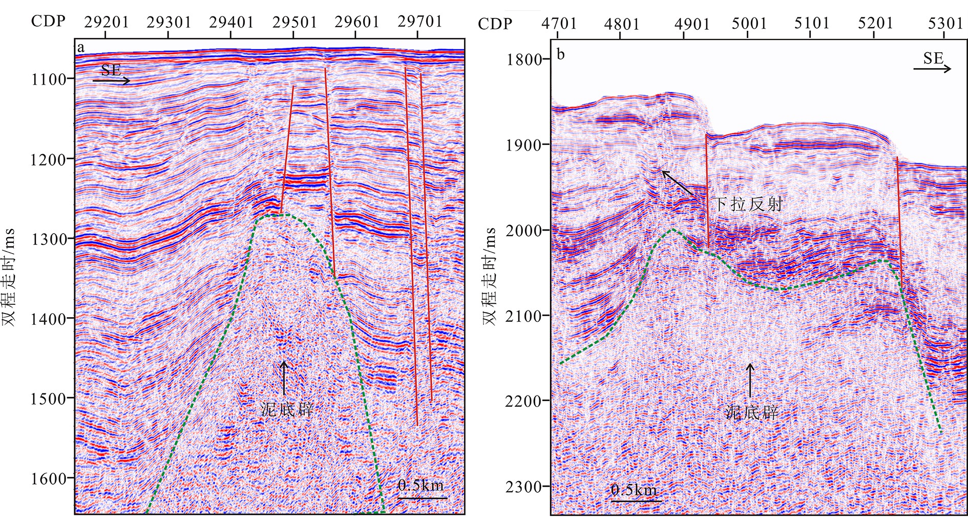
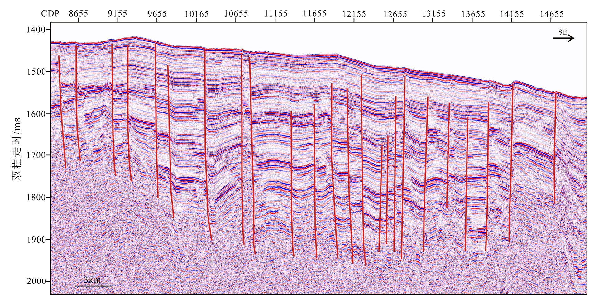
图 3 多道地震剖面显示的不同形态泥底辟
a. 锥状泥底辟,b. 蘑菇状泥底辟。
Figure 3. Mud diapirs with different morphology in multi-channel seismic section
a. conical shaped mud diapir, b. mushroom shaped mud diapir.
![]()
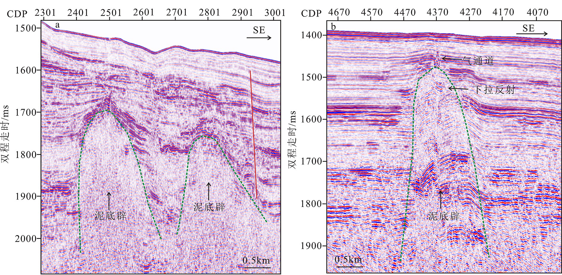
图 4 不同规模泥底辟
a. 深埋型泥底辟,b. 浅埋型泥底辟 。
Figure 4. Different scales of mud diapirs
a. deep buried mud diapir, b. shallow buried mud diapir.
![]()
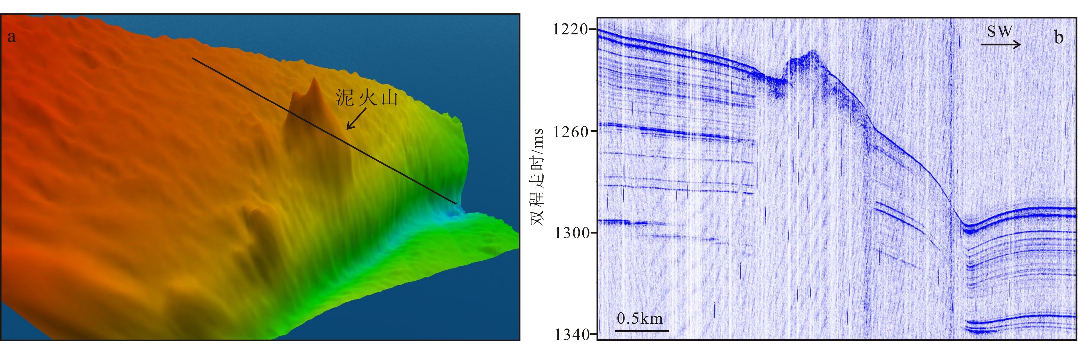
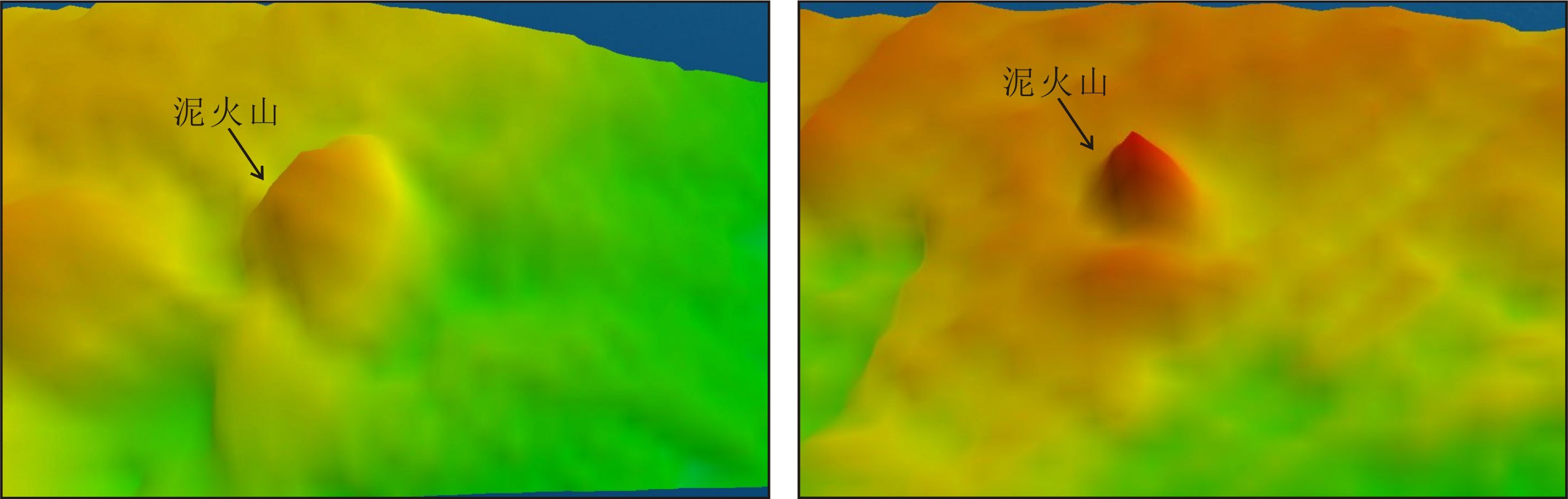
图 5 第1种类型泥火山多波束地形图和浅地层剖面
a. 多波束地形图;b. 过泥火山的浅地层剖面,测线位置如图5a所示。
Figure 5. Multi-beam bathymetry map and sub-bottom profile of the first type of mud volcano
a. multi-beam bathymetry map; b. the sub-bottom profile crossing the mud volcano, see Fig. 5a for location.
![]()
图 6 不规则状泥火山口多波束地形图和浅地层剖面
a. 多波束地形图;b. 过泥火山的为浅地层剖面,测线位置如图6a所示。
Figure 6. Multi-beam bathymetry map and sub-bottom profile of the irregular mud volcano summit caldera
a. multi-beam bathymetry map; b. the sub-bottom profile crossing the mud volcano. See Fig.6a for location.
![]()
图 7 圆锥状泥火山多波束地形图和浅地层剖面
a. 多波束地形图;b. 过泥火山的浅地层剖面,测线位置如图7a所示。
Figure 7. Multi-beam bathymetry map of conical mud volcanoes
a. multi-beam bathymetry map; b. the sub-bottom profile crossing the mud volcano. See Fig.7a for location.
![]()
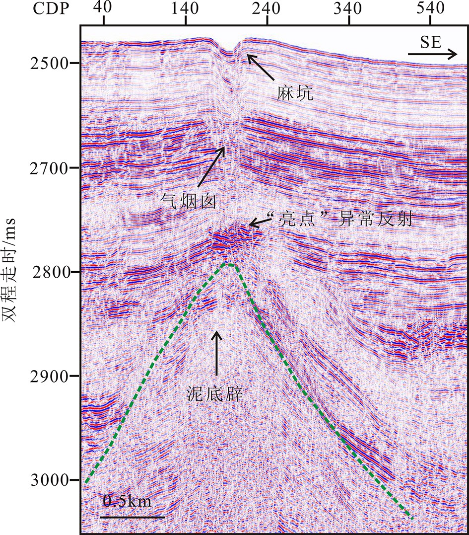
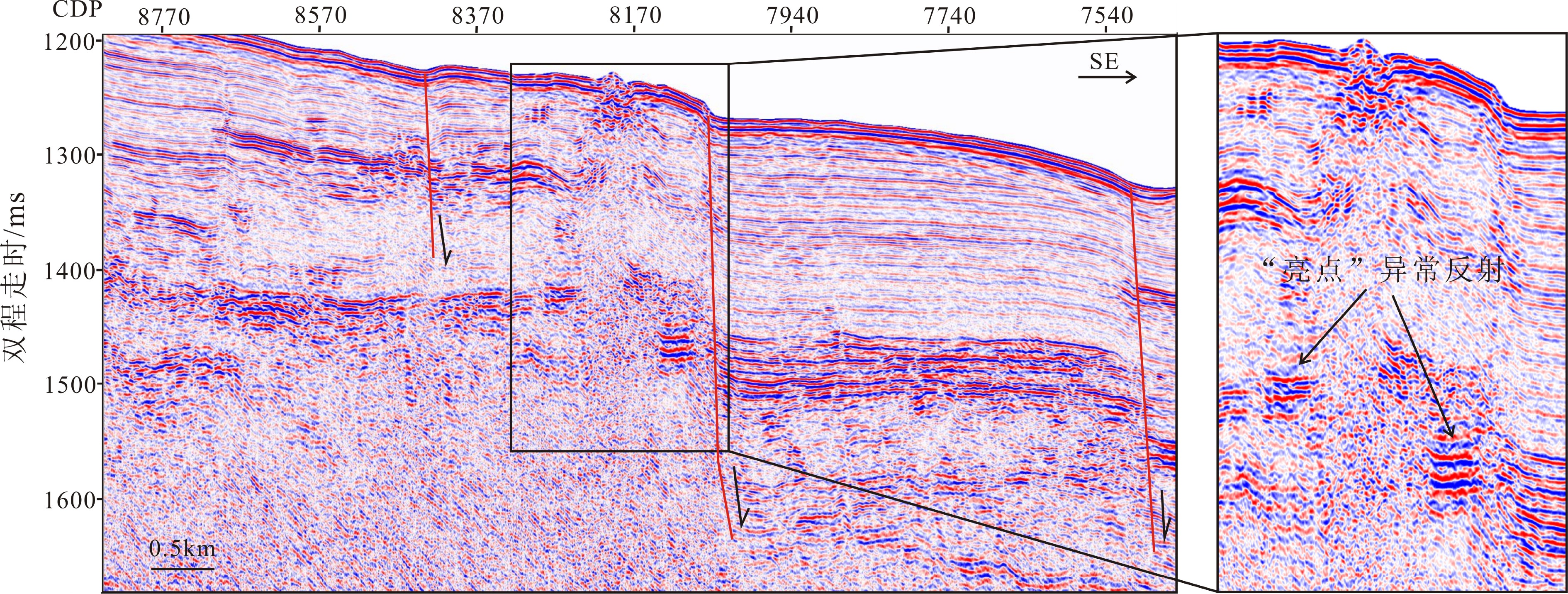
图 8 泥底辟之上发育“亮点”异常反射、气烟囱及麻坑
Figure 8. “Hot spot” abnormal reflections, notice the gas chimneys and porkmarks developed on the top of mud diapirs
![]()
图 10 泥火山周边发育环状塌陷构造
Figure 10. Mud volcanoes surrounded by collapse- subsidence structure
![]()
图 11 研究区最大的泥火山
a. 和b分别为过泥火山的多道地震剖面和浅地层剖面,位置如图11c所示;c. 多波束地形图;d. 瞬时频率属性剖面。
Figure 11. The largest mud volcano in the studied area
a. and b. are multi-channel seismic section and sub-bottom profile crossing the mud volcano, See Fig.11c for location.; c. multi-beam bathymetry map; d. instantaneous frequency profile.
-
[1] Kopf A, Robertson A H F, Clennell M B, et al. Mechanisms of mud extrusion on the Mediterranean Ridge Accretionary Complex [J]. Geo-Marine Letters, 1998, 18(2): 97-114. doi: 10.1007/s003670050058
[2] Mascle J, Mary F, Praeg D, et al. Distribution and geological control of mud volcanoes and other fluid/free gas seepage features in the Mediterranean Sea and nearby Gulf of Cadiz [J]. Geo-Marine Letters, 2014, 34(2-3): 89-110. doi: 10.1007/s00367-014-0356-4
[3] Lykousis V, Alexandri S, Woodside J, et al. Mud volcanoes and gas hydrates in the Anaximander mountains (Eastern Mediterranean Sea) [J]. Marine and Petroleum Geology, 2009, 26(6): 854-872. doi: 10.1016/j.marpetgeo.2008.05.002
[4] Sumner R H, Westbrook G K. Mud diapirism in front of the Barbados accretionary wedge: the influence of fracture zones and North America–South America plate motions [J]. Marine and Petroleum Geology, 2001, 18(5): 591-613. doi: 10.1016/S0264-8172(01)00010-1
[5] 耿明会, 宋海斌, 关永贤, 等. 南海东北部深水区泥火山的分布与特征[J]. 海洋地质前沿, 2019, 35(10):1-10 GENG Minghui, SONG Haibin, GUAN Yongxian., et al The distribution and characteristics of mud volcanoes in the northeastern south China sea [J]. Marine Geology Frontiers, 2019, 35(10): 1-10.
[6] 孟明, 龚建明, 廖晶. 马克兰增生楔海陆泥火山气源成因[J]. 海洋地质前沿, 2020, 36(5):43-48 MENG Ming, GONG Jianming, LIAO Jing. Difference in gas sources for offshore and onshore mud volcanoes in Makran accretionary wedge [J]. Marine Geology Frontiers, 2020, 36(5): 43-48.
[7] Xing J H, Spiess V, Shallow gas transport and reservoirs in the vicinity of deeply rooted mud volcanoes in the central Black Sea[J]. Marine Geology, 2015, 369: 67-78.
[8] 陈江欣, 关永贤, 宋海斌, 等. 麻坑、泥火山在南海北部与西部陆缘的分布特征和地质意义[J]. 地球物理学报, 2015, 58(3):919-938 doi: 10.6038/cjg20150319 CHEN Jiangxin, GUAN Yongxian, SONG Haibin, et al. Distribution characteristics and geological implications of pockmarks and mud volcanoes in the northern and western continental margins of the South China Sea [J]. Chinese Journal of Geophysics, 2015, 58(3): 919-938. doi: 10.6038/cjg20150319
[9] 张伟, 何家雄, 卢振权, 等. 琼东南盆地疑似泥底辟与天然气水合物成矿成藏关系初探[J]. 天然气地球科学, 2015, 26(11):2185-2197 doi: 10.11764/j.issn.1672-1926.2015.11.2185 ZHANG Wei, HE Jiaxiong, LU Zhenquan, et al. Preliminary study of the relationship between the suspected mud diapir and natural gas hydrate in the Qiongdongnan Basin, Northern South China Sea [J]. Natural Gas Geoscience, 2015, 26(11): 2185-2197. doi: 10.11764/j.issn.1672-1926.2015.11.2185
[10] 王潇, 阎贫, 于俊辉, 等. 东沙岛西南泥火山区的地震烃类检测[J]. 地球科学, 2021, 46(2):621-631 WANG Xiao, YAN Pin, YU Junhui, et al. Seismic detection for hydrocarbon in mud volcano-rich area Southwest to the Dongsha Island [J]. Earth Science, 2021, 46(2): 621-631.
[11] Wan Z F, Yao Y J, Chen K W, et al. Characterization of mud volcanoes in the northern Zhongjiannan Basin, western South China Sea [J]. Geological Journal, 2019, 54(1): 177-189. doi: 10.1002/gj.3168
[12] He J X, Wang S H, Zhang W, et al. Characteristics of mud diapirs and mud volcanoes and their relationship to oil and gas migration and accumulation in a marginal basin of the northern South China Sea [J]. Environmental Earth Sciences, 2016, 75(15): 1122. doi: 10.1007/s12665-016-5894-9
[13] Feseker T, Boetius A, Wenzhöfer F, et al. Eruption of a deep-sea mud volcano triggers rapid sediment movement [J]. Nature Communications, 2014, 5(1): 5385. doi: 10.1038/ncomms6385
[14] Rudolph M L, Shirzaei M, Manga M, et al. Evolution and future of the Lusi mud eruption inferred from ground deformation [J]. Geophysical Research Letters, 2013, 40(6): 1089-1092. doi: 10.1002/grl.50189
[15] Chang P Y, Yang T Y, Chyi L L, et al. Electrical resistivity variations before and after the pingtung earthquake in the wushanting mud volcano area in southwestern Taiwan [J]. Journal of Environmental and Engineering Geophysics, 2010, 15(4): 219-231. doi: 10.2113/JEEG15.4.219
[16] Rudolph M L, Manga M. Frequency dependence of mud volcano response to earthquakes [J]. Geophysical Research Letters, 2012, 39(14): L14303.
[17] Bonini M. Mud volcanoes: indicators of stress orientation and tectonic controls [J]. Earth-Science Reviews, 2012, 115(3): 121-152. doi: 10.1016/j.earscirev.2012.09.002
[18] 尚鲁宁, 张训华, 韩波. 重磁资料揭示的冲绳海槽及邻区断裂和岩浆岩分布[J]. 海洋地质与第四纪地质, 2016, 36(1):99-106 SHANG Luning, ZHANG Xunhua, HAN Bo. Fault belts and igneous rocks of the Okinawa Trough and adjacent areas: evidence from gravity and magnetic data [J]. Marine Geology & Quaternary Geology, 2016, 36(1): 99-106.
[19] Xu N, Wu S G, Shi B Q, et al. Gas hydrate associated with mud diapirs in southern Okinawa Trough [J]. Marine and Petroleum Geology, 2009, 26(8): 1413-1418. doi: 10.1016/j.marpetgeo.2008.10.001
[20] Yin P, Berné S, Vagner P, et al. Mud volcanoes at the shelf margin of the East China Sea [J]. Marine Geology, 2003, 194(3-4): 135-149. doi: 10.1016/S0025-3227(02)00678-3
[21] Xing J H, Jiang X D, Li D Y. Seismic study of the mud diapir structures in the Okinawa Trough [J]. Geological Journal, 2016, 51(S1): 203-208.
[22] Sibuet J C, Letouzey J, Barbier F, et al. Back arc extension in the Okinawa Trough [J]. Journal of Geophysical Research:Solid Earth, 1987, 92(B13): 14041-14063. doi: 10.1029/JB092iB13p14041
[23] Park J O, Tokuyama H, Shinohara M, et al. Seismic record of tectonic evolution and backarc rifting in the southern Ryukyu island arc system [J]. Tectonophysics, 1998, 294(1-2): 21-42. doi: 10.1016/S0040-1951(98)00150-4
[24] 刘博, 李三忠, 索艳慧, 等. 冲绳海槽地质属性及其动力学机制[C]//2016中国地球科学联合学术年会论文集[C]. 北京: 中国地球物理学会, 2016 LIU Bo, LI Sanzhong, SUO Yanhui, et al. Geological attributes and dynamic mechanism of Okinawa trough[C]//2016 Annual Meeting of Chinese Geoscience Union. Beijing: Chinese Geophysical Society, 2016.
[25] 杨文达. 冲绳海槽现代张裂的地球物理特征[J]. 海洋地质与第四纪地质, 2004, 24(3):77-82 YANG Wenda. Modern geophysical characteristics of tectonic tension fault in the Okinawa Trough [J]. Marine Geology & Quaternary Geology, 2004, 24(3): 77-82.
[26] 高金耀, 汪俊, 杨春国, 等. 冲绳海槽弧后张裂构造及其动力机制讨论[J]. 地球物理学进展, 2008, 23(4):1001-1012 GAO Jinyao, WANG Jun, YANG Chunguo, et al. Discussion on back-arc rifting tectonics and its geodynamic regime of the Okinawa Trough [J]. Progress in Geophysics, 2008, 23(4): 1001-1012.
[27] Shang L N, Zhang X H, Jia Y G, et al. Late Cenozoic evolution of the East China continental margin: insights from seismic, gravity, and magnetic analyses [J]. Tectonophysics, 2017, 698: 1-15. doi: 10.1016/j.tecto.2017.01.003
[28] 董刚, 蔡峰, 闫桂京, 等. 冲绳海槽西部陆坡第四纪沉积地层划分[J]. 地质学报, 2018, 92(12):2550-2560 doi: 10.3969/j.issn.0001-5717.2018.12.011 DONG Gang, CAI Feng, YAN Guijing, et al. Quaternary stratigraphic division in the western slope of Okinawa Trough [J]. Acta Geologica Sinica, 2018, 92(12): 2550-2560. doi: 10.3969/j.issn.0001-5717.2018.12.011
[29] 王舒畋, 梁寿生. 冲绳海槽盆地的地质构造特征与盆地演化历史[J]. 海洋地质与第四纪地质, 1986(2):17-29 WANG Shutian, LIANG Shousheng. Geologic-tectonic characteristics and evolution of Okinawa Trough basin [J]. Marine Geology & Quaternary Geology, 1986(2): 17-29.
[30] 李乃胜, 姜丽丽, 李常珍. 冲绳海槽地壳结构的研究[J]. 海洋与湖沼, 1998, 29(4):441-450 doi: 10.3321/j.issn:0029-814X.1998.04.016 LI Naisheng, JIANG Lili, LI Changzhen. A study on the nature of crustal structures of the Okinawa Trough [J]. Oceanologia et Limnologia Sinica, 1998, 29(4): 441-450. doi: 10.3321/j.issn:0029-814X.1998.04.016
[31] 李培英, 王永吉, 刘振夏. 冲绳海槽年代地层与沉积速率[J]. 中国科学(D辑), 1999, 42(4):408-415 LI Peiying, WANG Yongji, LIU Zhenxia. Chronostratigraphy and deposition rates in the Okinawa Trough region [J]. Science in China (Series D:Earth Sciences), 1999, 42(4): 408-415.
[32] 骆迪, 蔡峰, 吴志强, 等. 海洋短排列高分辨率多道地震高精度成像关键技术[J]. 地球物理学报, 2019, 62(2):730-742 doi: 10.6038/cjg2019M0178 LUO Di, CAI Feng, WU Zhiqiang, et al. The key technologies of marine small scale high resolution multichannel seismic high-precision imaging [J]. Chinese Journal of Geophysics, 2019, 62(2): 730-742. doi: 10.6038/cjg2019M0178
[33] Luo D, Cai F, Wu Z Q. Numerical simulation for accuracy of velocity analysis in small-scale high-resolution marine multichannel seismic technology [J]. Journal of Ocean University of China, 2017, 16(3): 370-382. doi: 10.1007/s11802-017-3145-7
[34] 骆迪, 蔡峰, 闫桂京, 等. 浅表层天然气水合物高分辨率地震勘探方法与应用[J]. 海洋地质前沿, 2020, 36(9):101-108 LUO Di, CAI Feng, YAN Guijing, et al. High resolution seismic method for shallow gas hydrates exploration [J]. Marine Geology Frontiers, 2020, 36(9): 101-108.
[35] 何家雄, 祝有海, 翁荣南, 等. 南海北部边缘盆地泥底辟及泥火山特征及其与油气运聚关系[J]. 地球科学:中国地质大学学报, 2010, 35(1):75-86 doi: 10.3799/dqkx.2010.008 HE Jiaxiong, ZHU Youhai, WENG Rongnan, et al. Characters of north-west mud diapirs volcanoes in south China sea and relationship between them and accumulation and migration of oil and gas [J]. Earth Science:Journal of China University of Geosciences, 2010, 35(1): 75-86. doi: 10.3799/dqkx.2010.008
[36] 李清, 蔡峰, 闫桂京, 等. 东海冲绳海槽泥火山发育区甲烷气体来源研究[J]. 海洋地质前沿, 2020, 36(9):79-86 LI Qing, CAI Feng, YAN Guijing, et al. Origin of pore water methane recovered from mud volcanos in the Okinawa Trough [J]. Marine Geology Frontiers, 2020, 36(9): 79-86.
[37] 李清, 蔡峰, 梁杰, 等. 东海冲绳海槽西部陆坡甲烷渗漏发育的孔隙水地球化学证据[J]. 中国科学:地球科学, 2015, 58(6):986-995 doi: 10.1007/s11430-014-5034-x LI Qing, CAI Feng, LIANG Jie, et al. Geochemical constraints on the methane seep activity in western slope of the middle Okinawa Trough, the East China Sea [J]. Science China Earth Sciences, 2015, 58(6): 986-995. doi: 10.1007/s11430-014-5034-x
[38] Xu C L, Wu N Y, Sun Z L, et al. Methane seepage inferred from pore water geochemistry in shallow sediments in the western slope of the Mid-Okinawa Trough [J]. Marine and Petroleum Geology, 2018, 98: 306-315. doi: 10.1016/j.marpetgeo.2018.08.021
[39] 李昂, 蔡峰, 李清,等. 浅表层泥火山型天然气水合物成藏地质模型[J]. 海洋地质前沿, 2020, 36(9):94-100 LI Ang, CAI Feng, LI Qing, et al. A geological model for shallow gas hydrates accumulation associated with mud volcano [J]. Marine Geology Frontiers, 2020, 36(9): 94-100.
[40] Dimitrov L I. Mud volcanoes: the most important pathway for degassing deeply buried sediments [J]. Earth-Science Reviews, 2002, 59(1-4): 49-76. doi: 10.1016/S0012-8252(02)00069-7
[41] 郭军华, 吴时国, 徐宁, 等. 冲绳海槽西侧陆坡及其邻区天然气水合物成藏构造特征[J]. 海洋与湖沼, 2007, 38(5):432-437 doi: 10.3321/j.issn:0029-814x.2007.05.006 GUO Junhua, WU Shiguo, XU Ning, et al. Structural characteristics of gas hydrate deposition in the west slope of the Okinawa Trough and its adjacent area [J]. Oceanologia et Limnologia Sinica, 2007, 38(5): 432-437. doi: 10.3321/j.issn:0029-814x.2007.05.006
[42] Talukder A R. Review of submarine cold seep plumbing systems: leakage to seepage and venting [J]. Terra Nova, 2012, 24(4): 255-272. doi: 10.1111/j.1365-3121.2012.01066.x

 下载:
下载:


计量
- 文章访问数: 2188
- HTML全文浏览量: 646
- PDF下载量: 109