Reconstruction of terrestrial input changes in sediments in the Western Pacific warm pool using bacterial membrane lipids
-
摘要: 西菲律宾海作为西太平洋暖池的一部分,重建其在地质历史时期的热力学变化、陆源输入变化,对于理解西太平洋暖池在全球地质时间尺度上的作用具有重要意义。利用古菌与细菌的细胞膜质甘油二烷基甘油四醚(glycerol dialkyl glycerol tetraethers, GDGTs)对西菲律宾海XT-47孔沉积物的陆源输入及其上方水体温度的变化进行重建,发现该沉积柱顶部(0~260 cm,约16.6~18.8 ka)BIT指标为0.01~0.2,TEXH86重建的上层海水平均温度为22.5 ℃,而底部(260~632 cm,约18.8~4 000 ka)TEXH86重建得到的上层海水温度绝对值波动剧烈(0.6~26 ℃),在此范围内BIT>0.3,并呈现逐渐增加的趋势, 超过BIT界定的陆源输入对TEXH86重建古温度有效性的阈值,这导致了该深度范围内TEXH86重建古温度变化的严重偏差。以260和470 cm为界,该沉积柱的沉积相出现明显变化,上层为大量纹层硅藻席沉积,中层为远洋黏土和硅藻泥互层,下层为远洋黏土沉积;同时,支链GDGTs(branched GDGTs, br GDGTs)的组成也出现明显差异,说明其来源可能有所不同。基于以上分析,提出260 cm以浅,brGDGTs可能主要为海相原位自生为主;而260 cm深度以下,主要以风尘输送的陆源brGDGTs为主。该结果显示陆源输入的变化可以间接反映东亚冬季风的强弱,本研究为高低纬之间的海陆相互作用研究提供了新的视角。Abstract: The West Philippine Sea is a part of the Western Pacific Warm Pool. To reconstruct its thermodynamic changes and terrestrial input changes in the geological history is of great significance for understanding the role of the Warm Pool on a global geological time scale. In this paper, the glycerol dialkyl glycerol tetraethers (GDGTs) of archaea and bacteria is used to reconstruct the temperature and terrestrial input proxy changes for the core XT-47 taking from the West Philippine Sea. The BIT index on top layer of 0~260 cm, corresponding to 16.6~18.8 ka, varies between 0.01~0.2, and the average sea surface temperature reconstructed with TEXH86 is 22.5°C. The absolute sea surface temperature at the bottom layer from 260 cm to 632 cm, (18.8~4 000 ka) reconstructed by TEXH86 fluctuates drastically between 0.6°C and 26°C; BIT>0.3 within these depth range, shows a gradual increase trend, exceeding the threshold for the validity of paleotemperature reconstruction of TEXH86 defined by terrestrial input proxy-BIT, which leads to a serious deviation of the TEXH86 reconstructed paleotemperature within this depth range. Taking 260 cm and 400 cm as boundaries, the sedimentary facies of the core has changed significantly. In a descending order, the upper layer is a large number of laminar diatom mats, the middle layer is interbedded pelagic clay and diatom clay, and the lower layer is pelagic clay deposit; simultaneously, obvious differences in the composition of branched GDGTs (brGDGTs) are observed, indicating that their sources may also be different. Based on the above analysis, we propose that brGDGTs below 260 cm are marine in-situ autochthonous deposits; while that below 260 cm, terrigenous brGDGTs dominate, which are mainly transported as aeolian dust. The results suggest that the changes in terrestrial input can indirectly reflect the strength of the East Asian winter monsoon, and the results may provide new insights for the study of sea-land interactions between high and low latitudes.
-
Keywords:
- terrestrial input /
- BIT index /
- GDGTs /
- diatom mats /
- TEXH86 /
- West Philippine Sea
-
天然气水合物是一种重要的战略能源和潜在未来能源,准确地探明中国的天然气水合物资源储量,有效地进行水合物资源的勘探开发,具有非常重要的战略意义、环境意义和经济意义。地震勘探是天然气水合物识别和预测的重要手段之一。地震资料上似海底反射层(BSR)、振幅空白带以及极性反转等地震反射特征[1-2],通常作为海域水合物储层的重要识别标志。地震反射主要是由储层波阻抗差异引起的,但在特定条件下岩性变化或者不整合面等原因也可能造成波阻抗差异,引起类似的地震响应。地震剖面上BSR常见于海域斜坡或者浅部海底沉积地层上,但在一些发现水合物的区域,并未表现出明显的BSR特征[3],如墨西哥湾、中国南海北部陆坡西部区域等,而且不同类型水合物储层的BSR特征也有较大差异[4-5]。BSR等地震反射特征与水合物地层并非一一对应关系,仅依靠地震反射特征难以准确识别天然气水合物[6],这对海域水合物储层的地震识别和预测提出了更高的要求。
天然气水合物的微观赋存形态是影响其储层特性的主要因素[7-8]。为提高水合物识别和预测的可靠性,一个重要的途径是从地震数据中准确提取天然气水合物地层的物性信息,为此需要解决两个关键问题:第一个问题是如何建立储层宏观弹性特征(包括体积模量、剪切模量、纵波速度、横波速度、密度等)与天然气水合物微观结构之间的定量关系。岩石物理建模是建立该定量关系的重要手段,目前应用较多的岩石物理模型包括适用于固结海洋沉积物的胶结模型[9-10]和等效介质模型[11-12]以及适用于未固结海洋沉积物的接触理论[13-15]等。这些岩石物理模型各自具有不同的假设条件和适用条件。水合物的微观赋存形态会因沉积环境的不同而显著变化,实验研究表明,水合物的存在会增强地层的剪切强度[16]。考虑水合物微观赋存形态及剪切性质的岩石物理型有待进一步研究。
第二个问题是如何建立水合物储层地震信息(包括振幅、相位、频率等动力学特征以及BSR、振幅空白带等地球物理响应)与弹性参数之间定量关系。地震反演方法是天然气水合物探测的有效技术手段之一。弹性阻抗反演[17-23]、AVO(Amplitude variation with offset,振幅随偏移距的变化)及AVA(Amplitude variation with angle,振幅随入射角度的变化)反演方法[24-26]以及全波形反演[27-28]等地震反演方法已在天然气水合物探测中取得了成功应用。然而,天然气水合物地层的宏观和微观结构高度复杂、非均质性强,成藏模式随不同区域而变化,基于地震数据进行水合物地层物性信息的定量反演仍存在一定的多解性[29-30],这对水合物的定量解释和勘探提出了挑战。目前流体识别的叠前地震反演方法日趋完善,并在多个地区取得了较好的应用效果[31],而水合物地层的微观赋存形态以及宏观沉积环境区别于常规含流体储层,因此此类反演方法在水合物地层的应用还有待进一步研究。
针对第一个问题,本文根据海域天然气水合物的微观结构特征,在岩石物理建模的框架下,考虑水合物非零剪切模量的特征,使用基于非耦合微分有效介质(DEM)理论和斑块饱和理论进行岩石物理建模,计算水合物地层物性参数与弹性参数的定量关系;针对第二个问题,在岩石物理分析的基础上,使用叠前贝叶斯地震反演方法,从叠前地震数据中提取水合物地层的剪切模量参数。实际应用结果表明,剪切模量对水合物含量有较好的指示性。本文的方法对水合物储层的识别提供了方法和技术支撑,对后续水合物物性参数定量反演提供新的思路。
1. 工区概况
神狐海域位于南海北部陆坡神狐暗沙东南海域附近(图1),水合物钻探区水深为1 000~1 500 m,新生代沉积厚度达1 000~7 000 m,具有扩散型天然气水合物的成藏系统。适宜的温压条件、丰富的气源供给,加之底辟构造、高角度断裂和垂向裂隙系统等有利的运移通道,为水合物发育创造了良好的条件[32]。2006年,广州海洋地质调查局在此区域实施了三维地震采集,2007年完成了中国首次天然气水合物钻探,成功获取了天然气水合物的实物样品。
![]() 图 1 研究区位置图a:神狐海域研究区构造(红色方块) ,b:研究区内水合物钻探站位分布Figure 1. The location of the study areaa: The tectonic map of the Shenhu area (red square), b: the distribution of hydrate drilling stations in the red square (enlarged)
图 1 研究区位置图a:神狐海域研究区构造(红色方块) ,b:研究区内水合物钻探站位分布Figure 1. The location of the study areaa: The tectonic map of the Shenhu area (red square), b: the distribution of hydrate drilling stations in the red square (enlarged)神狐海域水合物稳定带受到周围温压条件限制,含水合物沉积层基本上位于海底以下135~230 m,分布于强振幅BSR的上覆沉积地层中[33],大部分BSR与地层斜交,波形极性与海底同相轴极性相反,且上部发育弱振幅或者振幅空白带[34](图2)。横向上BSR反射振幅及垂向上BSR厚度均存在一定变化,主要是由于地层的孔隙度、渗透率等物性差异导致水合物饱和度不同而造成的。
2. 弹性参数计算
针对前述的第一个问题,本文采用岩石物理建模的方法,建立地层宏观弹性参数与天然气水合物微观结构之间的定量关系。陆红锋等[35]对岩芯进行了X射线衍射成分分析,指出神狐海域沉积物组分以碎屑矿物、黏土矿物和碳酸盐矿物为主,并给出了各组分的含量,据此假设岩石基质由方解石、石英、黏土等组成。水合物含量主要受地层岩性、孔隙的微观结构及表面性质的影响[8],神狐海域水合物主要分散状分布于矿物颗粒的孔隙中[36-37],由于南海沉积物中存在大量有孔虫壳体,水合物主要占据有孔虫壳体内部空间并堵塞了孔隙间的连通喉道,显著降低了沉积物的气、水渗透能力[38];研究还发现,黏土含量的增加会导致被黏土颗粒束缚的孔隙水含量也随之增加[39]。据此考虑孔隙几何形状和连通性,假设地层中孔隙空间包含不连通的束缚水孔隙以及连通的硬币状孔隙和椭球形孔隙,其中硬币状孔隙纵横比较小,受到压力易趋向于闭合,连通性较差,而椭球形孔隙纵横比较大,连通性较好。孔隙空间中可能存在水合物、游离气和水共存的情况[40],该地区的水合物呈现出典型的I型结构,甲烷气体的含量超过99.3%[41],据此,结合前人对水合物微观结构的研究结果(图3a、b),将水合物地层等效为图3c所示的等效介质。
![]() 图 3 实验室获取的水合物CT图像[42]及水合物等效介质模型a:原始图像,b:对a图红色框线内区域进行灰度分析、着色后放大图,c:等效介质模型。Figure 3. CT images of gas hydrate obtained in laboratory and equivalent medium model of gas hydrate-bearing sedimentsa: Original image, b: enlarged image of the area in the red frame after grey analysis and coloring, c: equivalent medium model of gas hydrate-bearing sediments.
图 3 实验室获取的水合物CT图像[42]及水合物等效介质模型a:原始图像,b:对a图红色框线内区域进行灰度分析、着色后放大图,c:等效介质模型。Figure 3. CT images of gas hydrate obtained in laboratory and equivalent medium model of gas hydrate-bearing sedimentsa: Original image, b: enlarged image of the area in the red frame after grey analysis and coloring, c: equivalent medium model of gas hydrate-bearing sediments.在地震岩石物理建模的理论框架下建立天然气水合物地层的岩石物理模型(主要流程见图4):
①利用Hashin-Shtrikman-Walpole界限[43]将矿物组分混合形成颗粒基质。
②在基质中加入充填束缚水的不连通孔隙,作为新的基质。束缚水孔隙纵横比假设为0.1。根据Kuster-Toksöz模型计算基质中加入束缚水孔隙之后的弹性参数:
$$\begin{split}& \left( {{\boldsymbol{K}} - {{\boldsymbol{K}}_{gr}}} \right){\left( {{\boldsymbol{K}} + 4{{{{\boldsymbol{R}}_{gr}}} \mathord{\left/ {\vphantom {{{{\boldsymbol{R}}_{gr}}} 3}} \right. } 3}} \right)^{ - 1}}\left( {{{\boldsymbol{K}}_{gr}}+ 4{{{{\boldsymbol{R}}_{gr}}} \mathord{\left/ {\vphantom {{{{\boldsymbol{R}}_{gr}}} 3}} \right. } 3}} \right) = \\&\quad{\phi _{wc}}\left( {{{\boldsymbol{K}}_w} - {{\boldsymbol{K}}_{gr}}} \right){{\boldsymbol{P}}^{wc}} \end{split}$$ (1) 其中,${\boldsymbol{K}} = (K,\mu )$,$ K $、$ \mu $分别为基质中加入束缚水孔隙之后的体积模量和剪切模量;${{\boldsymbol{K}}_{{\text{gr}}}} = ({K_{{\text{gr}}}},{\mu _{{\text{gr}}}})$,${{\boldsymbol{K}}_{\text{w}}} = ({K_{\text{w}}},{\mu _{\text{w}}})$分别为岩石基质和水的弹性模量;$ {\phi _{{\text{wc}}}} $为束缚水孔隙的孔隙度,${\boldsymbol{R}} = \left( {\mu ,\dfrac{\mu }{8}\dfrac{{9K + 8\mu }}{{K + 2\mu }}} \right)$;系数${{\boldsymbol{P}}^{{\text{wc}}}} = ({P^{{\text{wc}}}},{Q^{{\text{wc}}}})$是几何因子,由孔隙纵横比确定。
③利用非耦合DEM模型[44]向②得到的基质中加入干燥的硬币状孔隙和椭球形孔隙,形成干燥骨架:
$$ K_{\text{d}}^{}\left( \phi \right){\text{ = }}{K_1}{(1 - \phi )^{\left( {{P^0} + {P^1}} \right)}}{e^{{P^1}\phi }} $$ (2) $$ \mu _{\text{d}}^{}\left( \phi \right){\text{ = }}{\mu _1}{(1 - \phi )^{\left( {{Q^0} + {Q^1}} \right)}}{e^{{Q^1}\phi }} $$ (3) 其中,$K_{\text{d}}^{}$和$\mu _{\text{d}}^{}$分别是干燥骨架的体积模量和剪切模量;${P^0} = \dfrac{{{A_1}}}{{{A_4}}}$,${P^1} = \dfrac{{{A_2}{A_4} - {A_1}{A_5}}}{{A_4^2}}$,${Q^0} = \dfrac{{{C_1}}}{{{C_4}}} + \dfrac{{{D_1}}}{{{D_4}}}$,${Q^1} = \dfrac{{{C_2}{C_4} - {C_1}{C_5}}}{{C_4^2}} + \dfrac{{{D_2}{D_4} - {D_1}{D_5}}}{{D_4^2}}$,$ A_1,A_2.\ldots A_5 $,$ C_1,C_2.\ldots C_5 $和$ D_1,D_2.\ldots D_5 $等是与固体基质和孔隙纵横比有关的参数,具体表达式见文献[44]。根据Xu和White(1995)的岩石物理建模思想[45],假设硬币状孔隙的孔隙度与黏土体积含量成正比,其余的孔隙为椭球形孔隙。
④利用广义Gassmann方程[46]将水合物填充到硬币状孔隙中,形成水合物斑块:
$$ K_{\text{s}}^{ - 1} = K_{\text{d}}^{ - 1} - {\left( {K_{\text{d}}^{ - 1} - K_{\text{m}}^{ - 1}} \right)^2}{\left[ {\phi \left( {K_{if}^{ - 1} - K_\phi ^{ - 1}} \right) + \left( {K_{\text{d}}^{ - 1} - K_{\text{m}}^{ - 1}} \right)} \right]^{ - 1}} $$ (4) $$ \mu _{\text{s}}^{ - 1} = \mu _{\text{d}}^{ - 1} - {\left( {\mu _{\text{d}}^{ - 1} - \mu _{\text{m}}^{ - 1}} \right)^2}{\left[ {\phi \left( {\mu _{if}^{ - 1} - \mu _\phi ^{ - 1}} \right) + \left( {\mu _{\text{d}}^{ - 1} - \mu _{\text{m}}^{ - 1}} \right)} \right]^{ - 1}} $$ (5) 其中,$ {\mu _{\text{s}}} $是水合物充填斑块的剪切模量,$ {K_\phi } $和$ {\mu _\phi } $分别是与孔隙相关的体积模量和剪切模量,$ {K_{if}} $和$ {\mu _{if}} $分别是第$i$种孔隙充填物的体积和剪切模量。利用广义Gassmann方程可以得到固体(如有机质、水合物等)充填于孔隙情况下的饱和岩石的弹性模量。
利用Gassmann方程将水/气填充到椭球形孔隙中,形成水/气斑块;最后,利用斑块饱和模型[47]和Reuss平均[48]将水合物斑块和水/气斑块混合,形成饱和岩石:
$$ {K_{\text{R}}} = {\left\langle {{{\left( {K + 4{\mu \mathord{\left/ {\vphantom {\mu 3}} \right. } 3}} \right)}^{ - 1}}} \right\rangle ^{ - 1}} - 4{\mu \mathord{\left/ {\vphantom {\mu 3}} \right. } 3} $$ (6) $$ {\mu _{\text{R}}} = {\left( {\sum\limits_{i = 1}^N {{{{f_i}} \mathord{\left/ {\vphantom {{{f_i}} {{\mu _i}}}} \right. } {{\mu _i}}}} } \right)^{ - 1}} $$ (7) 其中,$ {K_{\text{R}}} $和${\mu _{\text{R}}}$分别表示饱和沉积物的等效体积和剪切模量;${f_i}$为其体积含量;$ \left\langle \cdot \right\rangle $表示对每个斑块按体积含量进行加权平均;$ {\mu _i} $为第$ i $个斑块的剪切模量。
根据上述岩石物理模型计算水合物地层的弹性参数。假设地层的矿物组分为石英和黏土,孔隙度为35%,硬币状和椭球形孔隙的纵横比分别假设为0.04和0.35,孔隙中充填水合物和水,选取的其余弹性常数如表1所示。剪切模量和纵波速度随水合物剪切模量的变化如图5所示,两者都随水合物剪切模量的增大而增大,水合物饱和度越高,地层剪切模量随水合物剪切模量的变化越大。
表 1 数值计算所选用的弹性常数Table 1. The elastic constants used for numerical calculation组分 体积模量/GPa 剪切模量/GPa 密度/(g/cm3) 来源 石英 37.0 44.0 2.65 Carmichale, 1989 黏土 21.0 7.0 2.60 Tosaya and Nur, 1982 水合物 7.7 3.2 0.91 Waite et al, 2000 水 2.25 1000 ![]() 图 5 水合物地层纵波速度(a)和剪切模量(b)随水合物剪切模量的变化Figure 5. P-wave velocity (a) and shear modulus (b) of gas hydrate-bearing sediments versus shear modulus of gas hydrate component
图 5 水合物地层纵波速度(a)和剪切模量(b)随水合物剪切模量的变化Figure 5. P-wave velocity (a) and shear modulus (b) of gas hydrate-bearing sediments versus shear modulus of gas hydrate component使用下式计算弹性参数对水合物含量的敏感性评价指标:
$$ {D_{{S_i}}} = \left| {\frac{{{P_{{S_i}}} - {P_{{S_0}}}}}{{{P_{{S_0}}}}}} \right| $$ (8) 其中,${D_{{S_i}}}$和${P_{{s_i}}}$分别表示水合物饱和度为${S_i}$时的敏感性评价指标和弹性参数;${P_{{s_0}}}$表示地层不含水合物时的弹性参数。计算不同弹性参数对水合物含量的敏感性评价指标(图6)发现,纵波速度、横波速度、泊松比、体积模量和剪切模量等弹性参数对水合物含量都有一定的敏感性,但是泊松比的敏感性较低,纵波速度和横波速度对水合物含量的敏感性相当,剪切模量对水合物含量的敏感性最高。这与数值计算的结论是一致的,也证明了使用剪切模量参数来识别水合物的可行性。
![]() 图 6 不同弹性参数的敏感性评价指标Figure 6. Sensitivity indicator for hydrate content of different elastic parameters
图 6 不同弹性参数的敏感性评价指标Figure 6. Sensitivity indicator for hydrate content of different elastic parameters2007年在神狐海域共实施了8个天然气水合物钻探站位,其中SH2、SH3和SH7站位钻遇了水合物样品。其中SH2站位水合物厚度约25 m,位于海底以下195~220 m,平均饱和度25%[49],最高值达48%,部分测井曲线如图7所示。
![]() 图 7 SH2站位测井曲线绿色层段表示水合物地层。Figure 7. Well logging data of SH2 siteThe green section represents hydrate-bearing sediments.
图 7 SH2站位测井曲线绿色层段表示水合物地层。Figure 7. Well logging data of SH2 siteThe green section represents hydrate-bearing sediments.针对本研究区内的SH2站位,使用上述建模方法计算站位处的弹性参数。硬币状孔隙和椭球形孔隙各自的纵横比根据实测纵波速度反演求得。计算得到的纵横波速度以及剪切模量如图8所示。计算的纵波速度和与实测纵波速度有较好的一致性,两者相关系数为0.824,方差为
0.0182 ,绝对误差平均值为48.49 m/s。对计算得到的弹性参数进行交会分析(图9),实测纵波速度和自然伽马对水合物含量的区分能力有限,而剪切模量对于水合物含量有较好的指示作用,较高水合物饱和度的地层对应着较高的剪切模量。![]() 图 8 SH2站位水合物地层的水合物饱和度及弹性参数计算结果a:根据实测电阻率曲线计算的水合物饱和度,b:纵波速度(红色曲线表示实测值,黑色曲线表示计算值),c:横波速度计算值;d:剪切模量计算值。Figure 8. Calculation results of hydrate saturation and elastic parameters of hydrate strata at SH2 sitea: hydrate saturation calculated according to the measured resistivity, b: P-wave velocity (red curve represents the measured value, black curve represents the calculated value), c: calculated shear wave velocity; d: calculated shear modulus.
图 8 SH2站位水合物地层的水合物饱和度及弹性参数计算结果a:根据实测电阻率曲线计算的水合物饱和度,b:纵波速度(红色曲线表示实测值,黑色曲线表示计算值),c:横波速度计算值;d:剪切模量计算值。Figure 8. Calculation results of hydrate saturation and elastic parameters of hydrate strata at SH2 sitea: hydrate saturation calculated according to the measured resistivity, b: P-wave velocity (red curve represents the measured value, black curve represents the calculated value), c: calculated shear wave velocity; d: calculated shear modulus.![]() 图 9 SH2站位水合物地层弹性参数交会图a:实测纵波速度和实测自然伽马交会图,b:计算的体积模量和剪切模量交会图。Figure 9. Crossplots of elastic parameters of hydrate-bearing sediments at SH2 sitea: Crossplot of measured P-wave velocity and measured Gamma, b: crossplot of calculated bulk modulus and shear modulus.
图 9 SH2站位水合物地层弹性参数交会图a:实测纵波速度和实测自然伽马交会图,b:计算的体积模量和剪切模量交会图。Figure 9. Crossplots of elastic parameters of hydrate-bearing sediments at SH2 sitea: Crossplot of measured P-wave velocity and measured Gamma, b: crossplot of calculated bulk modulus and shear modulus.3. 叠前地震反演
关于纵波模量和剪切模量的弹性阻抗方程,其标准化形式为[50]:
$$ {\text{EI}}(\theta ) = {({M_0}{\rho _0})^{\frac{1}{2}}}{\left( {\frac{M}{{{M_0}}}} \right)^{a(\theta )}}{\left( {\frac{\mu }{{{\mu _0}}}} \right)^{b(\theta )}}{\left( {\frac{\rho }{{{\rho _0}}}} \right)^{c(\theta )}} $$ (9) 其中,$ {\text{EI}} $为弹性阻抗,$ M $和$ \mu $分别为饱和岩石的纵波模量和剪切模量(横波模量),$a = \frac{1}{2}{\sec ^2}\theta $,$ b = - 4\gamma _{}^2{\sin ^2}\theta $,$c = 1 - \frac{1}{2}{\sec ^2}\theta $,$\theta $为入射角。
结合岩石物理框架下弹性参数的计算结果,从测井资料以及地震资料出发,利用弹性阻抗贝叶斯反演方法计算得到弹性阻抗,然后使用上式进行纵横波模量的直接提取。该方法不需要先提取纵横波速度及密度信息,因此避免了从弹性阻抗计算纵横波速度再计算剪切模量过程中的累积误差。
弹性阻抗贝叶斯反演得到的弹性阻抗体以及直接反演得到的水合物地层剪切模量如图10所示。反演结果整体横向连续性较好,水合物地层分属高剪切模量数值区间,与岩石物理交会分析的认识相吻合;测井纵波速度增大的位置与剪切模量较高的位置匹配较好,反演结果与SH2井的实际测井钻遇结果保持较高一致性,验证了本工区使用剪切模量直接反演方法进行水合物识别的可靠性。
![]() 图 10 SH2站位水合物地层弹性参数交会图蓝色曲线为SH2井的实测纵波速度曲线。a:中角度叠加地震剖面,中心角度为20°;b:中角度弹性阻抗剖面,中心角度为20°;c:反演得到的剪切模量剖面。Figure 10. Seismic, elastic impedance, and inverted shear modulus profiles of SH2 siteThe blue curve is the measured P-wave velocity of SH2 site. a: Partial stack seismic profile at centric angle of 20°; b: elastic impedance profile at centric angle of 20°; c: inverted shear modulus profile.
图 10 SH2站位水合物地层弹性参数交会图蓝色曲线为SH2井的实测纵波速度曲线。a:中角度叠加地震剖面,中心角度为20°;b:中角度弹性阻抗剖面,中心角度为20°;c:反演得到的剪切模量剖面。Figure 10. Seismic, elastic impedance, and inverted shear modulus profiles of SH2 siteThe blue curve is the measured P-wave velocity of SH2 site. a: Partial stack seismic profile at centric angle of 20°; b: elastic impedance profile at centric angle of 20°; c: inverted shear modulus profile.4. 结论
(1)考虑神狐海域天然气水合物的微观结构特征,基于测井数据和地震数据,使用岩石物理建模以及叠前贝叶斯地震反演方法,从叠前地震数据中提取水合物地层的剪切模量参数,与SH2站位测井钻遇结果保持较高一致性,验证了使用剪切模量反演方法进行水合物识别的可靠性和有效性。
(2)在岩石物理建模过程中,对于水合物地层的微观结构,本文主要是通过矿物组分、孔隙结构以及水合物和矿物颗粒的接触关系来描述。实际水合物地层的微观结构随沉积环境以及富集条件的变化而差别非常大,因此等效岩石物理模型所用的一些物性参数,比如孔隙形状以及各类孔隙的孔隙度,都是对实际地层微观结构的等效近似。针对水合物地层的矿物组分以及水合物在地层中的赋存状态,许多学者通过CT图像以及实验等途径,给出了具体的描述和大量的数据,这些都是本文进行岩石物理建模的依据。
(3)本文的方法适用于孔隙充填型水合物地层,为该类水合物地层的识别和预测提供了一种新的思路和可靠的方法。但是海域水合物的赋存状态多样,包括颗粒支撑型、裂缝充填型等,不同类型的水合物需要通过岩石物理建模和交会分析等方法查明弹性参数对水合物含量的敏感性,确定敏感弹性参数,再使用地震反演方法进行敏感弹性参数的提取。
-
![]()
图 1 研究区域风场及洋流示意图
Figure 1. Schematic diagram of wind field and ocean currents in the study area
![]()
图 3 XT-47沉积柱记录的深度与年龄、沉积速率对应关系
绿色十字表示用有机碳AMS 14C测年的控制点;黄色十字表示用放射虫生物地层学年龄的控制点。
Figure 3. Correlation between depth, age and sedimentation rate of core XT-47
Green crosses: bulk organic carbon AMS 14C ages; Yellow crosses: radiolarian biostratigraphic ages.
![]()
图 4 XT-47沉积物岩性特征、陆源输入指标(BIT)、上层海水温度(SST)、总brGDGTs含量变化及其与同纬度南海站位SST[21]和中国黄土粒径指标对比[22]
图中BIT、SST和总brGDGTs曲线均由数据点局部加权回归拟合得到;灰色区域中的数字代表MIS时期,LDM:灰色纹层硅藻席,DC:灰黄色硅藻泥,PC:红褐色远洋黏土。
Figure 4. XT-47 sediment lithology, variations of terrestrial input proxy(BIT), sea surface temperature(SST), changes of total brGDGTs compared with SST of South China Sea station site at the same latitude[21], and grains size ratio(G.S.R)of Chinese loess[22]
The curves of BIT, SST and total brGDGTs in the figure are all obtained by data point locally weighted regression(LOESS)fitting. The numbers in the gray area represent the MIS stages. LDM: gray laminated diatom mat; DC: gray-yellow diatom clay; PC: reddish brown pelagic clay.
![]()
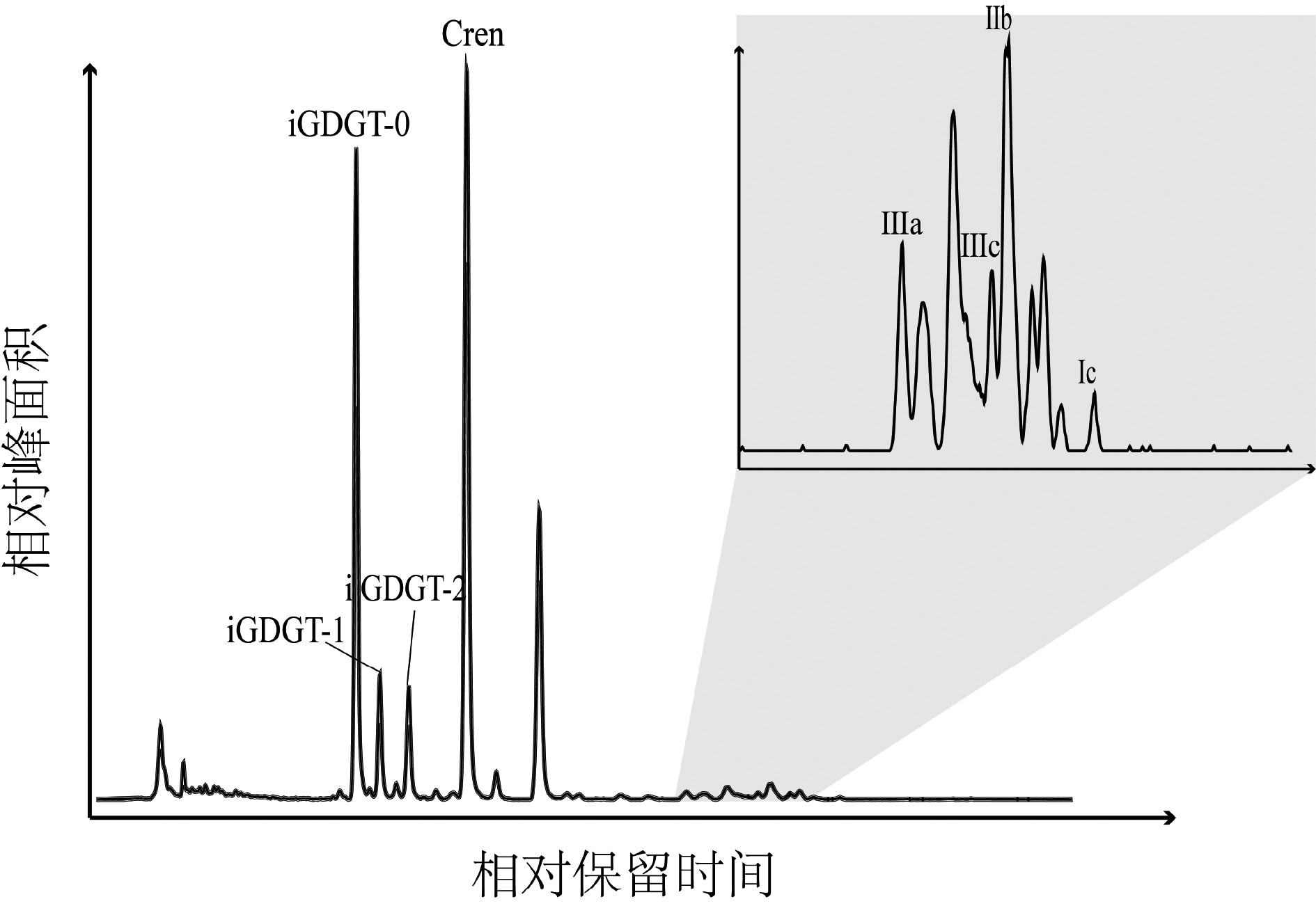
图 5 沉积物中iGDGTs和brGDGTs的液相色谱-质谱图
Figure 5. Total HPLC-MS ion chromatogram of iGDGTs(a)and brGDGTs(b)of a typical marine sediment sample
![]()
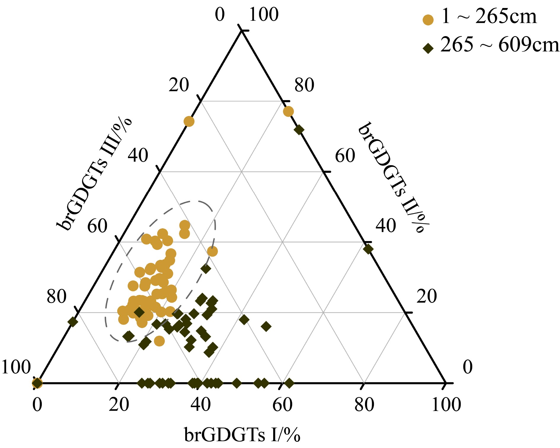
图 6 不同端元brGDGTs三元图分布
Figure 6. Ternary graphs of distributions of brGDGTs with different end-members
表 1 确定XT-47沉积柱年龄模型的年龄控制点及定年方法
Table 1 Age control points and dating method to determine the core XT-47 age model
深度/cm 年龄/kaBP 定年方法 17 16.8 有机碳AMS 14C 257 18.8 有机碳AMS 14C 471 340 放射虫 473 510 放射虫 505 1300 放射虫 561 2609 放射虫  下载: 导出CSV
-
[1] Lea D W. The glacial tropical pacific-not just a west side story [J]. Science, 2002, 297(5579): 202-203. doi: 10.1126/science.1073841
[2] Xu Z K, Li T G, Wan S M, et al. Evolution of East Asian monsoon: Clay mineral evidence in the western Philippine Sea over the past 700 kyr [J]. Journal of Asian Earth Sciences, 2012, 60: 188-196. doi: 10.1016/j.jseaes.2012.08.018
[3] Xu Z K, Li T G, Clift P D, et al. Quantitative estimates of Asian dust input to the western Philippine Sea in the mid-late Quaternary and its potential significance for paleoenvironment [J]. Geochemistry, Geophysics, Geosystems, 2015, 16(9): 3182-3196. doi: 10.1002/2015GC005929
[4] Hun C A, Peng J L, Chen J C. Late Pleistocene pelagic sedimentation in the West Philippine Basin [J]. Journal of Southeast Asian Earth Sciences, 1992, 7(2-3): 159-164. doi: 10.1016/0743-9547(92)90050-L
[5] Seo I, Lee Y I, Yoo C M, et al. Sr-Nd isotope composition and clay mineral assemblages in eolian dust from the central Philippine Sea over the last 600 kyr: Implications for the transport mechanism of Asian dust: Source and transport agent of Asian dust [J]. Journal of Geophysical Research: Atmospheres, 2014, 119(19): 11492-11504. doi: 10.1002/2014JD022025
[6] 李铁刚, 熊志方, 翟滨. 低纬度西太平洋硅藻席沉积与碳循环[M]. 北京: 海洋出版社, 2015: 1-158. LI Tiegang, XIONG Zhifang, ZHAI Bin. Laminated Diatom Mat Deposits from the Low-Latitude Western Pacific Linked to Global Carbon Cycle[M]. Beijing: China Ocean Press, 2015: 1-158.
[7] Xu Z K, Li T G, Wan S M, et al. Geochemistry of rare earth elements in the mid-late Quaternary sediments of the western Philippine Sea and their paleoenvironmental significance [J]. Science China Earth Sciences, 2014, 57(4): 802-812. doi: 10.1007/s11430-013-4786-z
[8] Qiu B. Kuroshio and oyashio currents[M]//Steele J H. Encyclopedia of Ocean Sciences. London: Elsevier Science Ltd., 2001: 1413-1425.
[9] Liu J P, Xu K H, Li A C, et al. Flux and fate of Yangtze River sediment delivered to the East China Sea [J]. Geomorphology, 2007, 85(3-4): 208-224. doi: 10.1016/j.geomorph.2006.03.023
[10] Wan S M, Yu Z J, Clift P D, et al. History of Asian eolian input to the West Philippine Sea over the last one million years [J]. Palaeogeography, Palaeoclimatology, Palaeoecology, 2012, 326-328: 152-159. doi: 10.1016/j.palaeo.2012.02.015
[11] Jiang F Q, Zhou Y, Nan Q Y, et al. Contribution of Asian dust and volcanic material to the western Philippine Sea over the last 220 kyr as inferred from grain size and Sr-Nd isotopes [J]. Journal of Geophysical Research: Oceans, 2016, 121(9): 6911-6928. doi: 10.1002/2016JC012000
[12] 万世明, 徐兆凯. 西太平洋风尘沉积记录研究进展[J]. 海洋与湖沼, 2017, 48(6):1208-1219. [WAN Shiming, XU Zhaokai. Research progress on eolian dust records in the west pacific [J]. Oceanologia et Limnologia Sinica, 2017, 48(6): 1208-1219. [13] Jiang F Q, Frank M, Li T G, et al. Asian dust input in the western Philippine Sea: Evidence from radiogenic Sr and Nd isotopes [J]. Geochemistry, Geophysics, Geosystems, 2013, 14(5): 1538-1551. doi: 10.1002/ggge.20116
[14] Wan S M, Sun Y B, Nagashima K. Asian dust from land to sea: processes, history and effect from modern observation to geological records [J]. Geological Magazine, 2020, 157(5): 701-706. doi: 10.1017/S0016756820000333
[15] Ge H M, Zhang C L. Advances in GDGT research in Chinese marginal seas: A review [J]. Science China Earth Sciences, 2016, 59(6): 1173-1186. doi: 10.1007/s11430-015-5242-z
[16] Schouten S, Hopmans E C, Damsté J S S. The organic geochemistry of glycerol dialkyl glycerol tetraether lipids: A review [J]. Organic Geochemistry, 2013, 54: 19-61. doi: 10.1016/j.orggeochem.2012.09.006
[17] Pearson A, Ingalls A E. Assessing the use of archaeal lipids as marine environmental proxies [J]. Annual Review of Earth and Planetary Sciences, 2013, 41: 359-384. doi: 10.1146/annurev-earth-050212-123947
[18] Schouten S, Hopmans E C, Schefuß E, et al. Distributional variations in marine crenarchaeotal membrane lipids: a new tool for reconstructing ancient sea water temperatures? [J]. Earth and Planetary Science Letters, 2002, 204(1-2): 265-274. doi: 10.1016/S0012-821X(02)00979-2
[19] Li D W, Zhao M X, Tian J, et al. Comparison and implication of TEX86 and UK’ 37 temperature records over the last 356 kyr of ODP Site 1147 from the northern South China Sea [J]. Palaeogeography, Palaeoclimatology, Palaeoecology, 2013, 376: 213-223. doi: 10.1016/j.palaeo.2013.02.031
[20] Hopmans E C, Weijers J W H, Schefuß E, et al. A novel proxy for terrestrial organic matter in sediments based on branched and isoprenoid tetraether lipids [J]. Earth and Planetary Science Letters, 2004, 224(1-2): 107-116. doi: 10.1016/j.jpgl.2004.05.012
[21] Pelejero C, Grimalt J O, Heilig S, et al. High-resolution UK37 temperature reconstructions in the South China Sea over the past 220 kyr [J]. Paleoceanography and Paleoclimatology, 1999, 14(2): 224-231.
[22] Ding Z L, Liu T S, Rutter N W, et al. Ice-volume forcing of East Asian winter monsoon variations in the past 800, 000 years [J]. Quaternary Research, 1995, 44(2): 149-159. doi: 10.1006/qres.1995.1059
[23] Kim J H, Van Der Meer J, Schouten S, et al. New indices and calibrations derived from the distribution of crenarchaeal isoprenoid tetraether lipids: Implications for past sea surface temperature reconstructions [J]. Geochimica et Cosmochimica Acta, 2010, 74(16): 4639-4654. doi: 10.1016/j.gca.2010.05.027
[24] Yamamoto M, Shimamoto A, Fukuhara T, et al. Source, settling and degradation of branched glycerol dialkyl glycerol tetraethers in the marine water column [J]. Geochimica et Cosmochimica Acta, 2016, 191: 239-254. doi: 10.1016/j.gca.2016.07.014
[25] Winckler G, Anderson R F, Fleisher M Q, et al. Covariant glacial-interglacial dust fluxes in the equatorial Pacific and Antarctica [J]. Science, 2008, 320(5872): 93-96. doi: 10.1126/science.1150595
[26] Xu Z K, Li T G, Yu X K, et al. Sediment provenance and evolution of the East Asian winter monsoon since 700 ka recorded by major elements in the West Philippine Sea [J]. Chinese Science Bulletin, 2012, 58(9): 1044-1052.
[27] De Jonge C, Stadnitskaia A, Hopmans E C, et al. Drastic changes in the distribution of branched tetraether lipids in suspended matter and sediments from the Yenisei River and Kara Sea (Siberia): Implications for the use of brGDGT-based proxies in coastal marine sediments [J]. Geochimica et Cosmochimica Acta, 2015, 165: 200-225. doi: 10.1016/j.gca.2015.05.044
[28] Xiao W J, Wang Y H, Zhou S Z, et al. Ubiquitous production of branched glycerol dialkyl glycerol tetraethers (brGDGTs) in global marine environments: a new source indicator for brGDGTs [J]. Biogeosciences, 2016, 13(20): 5883-5894. doi: 10.5194/bg-13-5883-2016
[29] Liu XL, Zhu C, Wakeham SG, et al. In situ production of branched glycerol dialkyl glycerol tetraethers in anoxic marine water columns [J]. Marine Chemistry, 2014, 166: 1-8. doi: 10.1016/j.marchem.2014.08.008
[30] Zhu C, Weijers J W H, Wagner T, et al. Sources and distributions of tetraether lipids in surface sediments across a large river-dominated continental margin [J]. Organic Geochemistry, 2011, 42(4): 376-386. doi: 10.1016/j.orggeochem.2011.02.002
[31] Damsté J S S. Spatial heterogeneity of sources of branched tetraethers in shelf systems: The geochemistry of tetraethers in the Berau River delta (Kalimantan, Indonesia) [J]. Geochimica et Cosmochimica Acta, 2016, 186: 13-31. doi: 10.1016/j.gca.2016.04.033
[32] Weijers J W H, Schouten S, Van Den Donker J C, et al. Environmental controls on bacterial tetraether membrane lipid distribution in soils [J]. Geochimica et Cosmochimica Acta, 2007, 71(3): 703-713. doi: 10.1016/j.gca.2006.10.003
[33] Peterse F, Schouten S, Van Der Meer J, et al. Distribution of branched tetraether lipids in geothermally heated soils: Implications for the MBT/CBT temperature proxy [J]. Organic Geochemistry, 2009, 40(2): 201-205. doi: 10.1016/j.orggeochem.2008.10.010
[34] Weijers J W H, Schouten S, Spaargaren O C, et al. Occurrence and distribution of tetraether membrane lipids in soils: Implications for the use of the TEX86 proxy and the BIT index [J]. Organic Geochemistry, 2006, 37(12): 1680-1693. doi: 10.1016/j.orggeochem.2006.07.018
[35] 陈敏, 兰彬斌, 沈林南, 等. 西菲律宾海盆表层沉积硅藻分布特征[J]. 微体古生物学报, 2014, 31(4):321-334. [CHEN Min, LAN Binbin, SHEN Linnan, et al. Characteristics of diatom distribution in the surface sediments of the Western Philippine Basin [J]. Acta Micropalaeontologica Sinica, 2014, 31(4): 321-334. [36] De Deckker P, Gingele F X. On the occurrence of the giant diatom Ethmodiscus rex in an 80-ka record from a deep-sea core, southeast of Sumatra, Indonesia: implications for tropical palaeoceanography [J]. Marine Geology, 2002, 183(1-4): 31-43. doi: 10.1016/S0025-3227(01)00252-3
[37] Harrison K G. Role of increased marine silica input on paleo-pCO2 levels [J]. Paleoceanography and Paleoclimatology, 2000, 15(3): 292-298.
[38] Nozaki Y, Yamamoto Y. Radium 228 based nitrate fluxes in the eastern Indian Ocean and the South China Sea and a silicon-induced “alkalinity pump” hypothesis [J]. Global Biogeochemical Cycles, 2001, 15(3): 555-567. doi: 10.1029/2000GB001309


计量
- 文章访问数: 1957
- HTML全文浏览量: 336
- PDF下载量: 94