Response of beach characteristics to typhoon “Yagi”: Evidence from Argus video images and on-site measurement
-
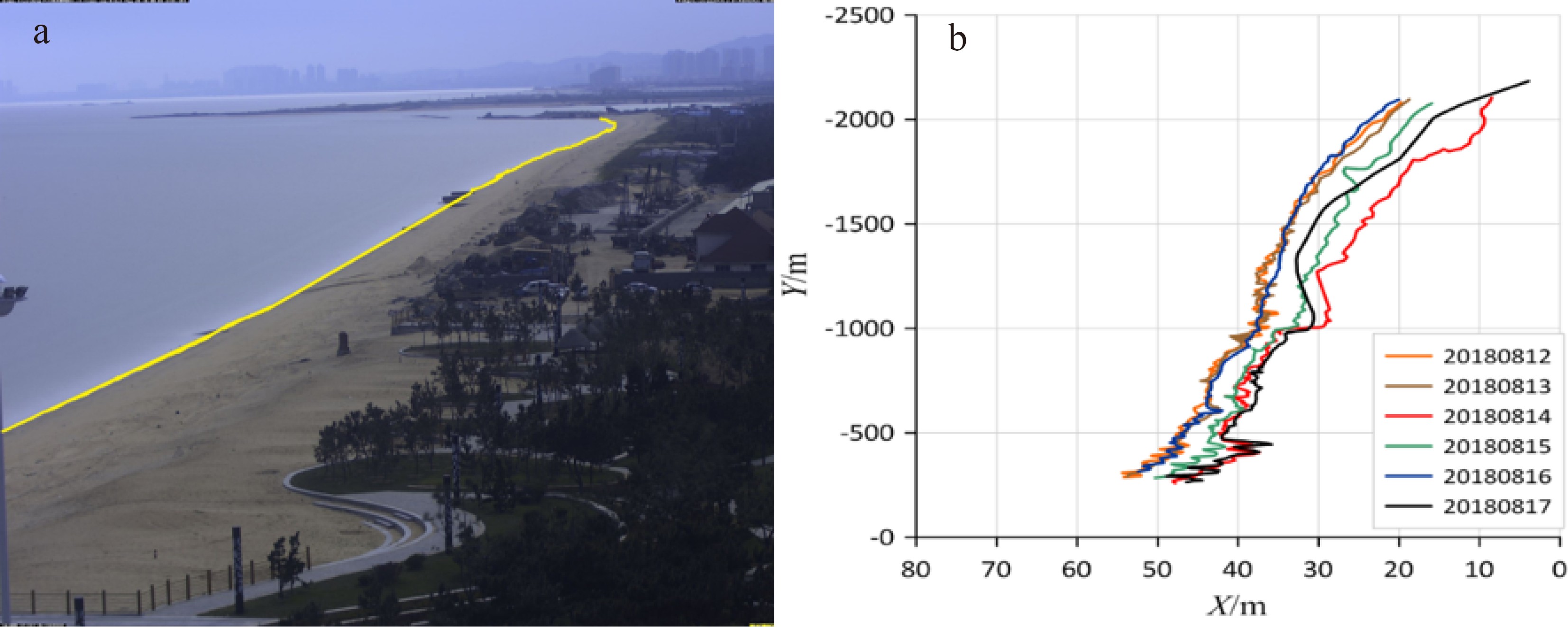
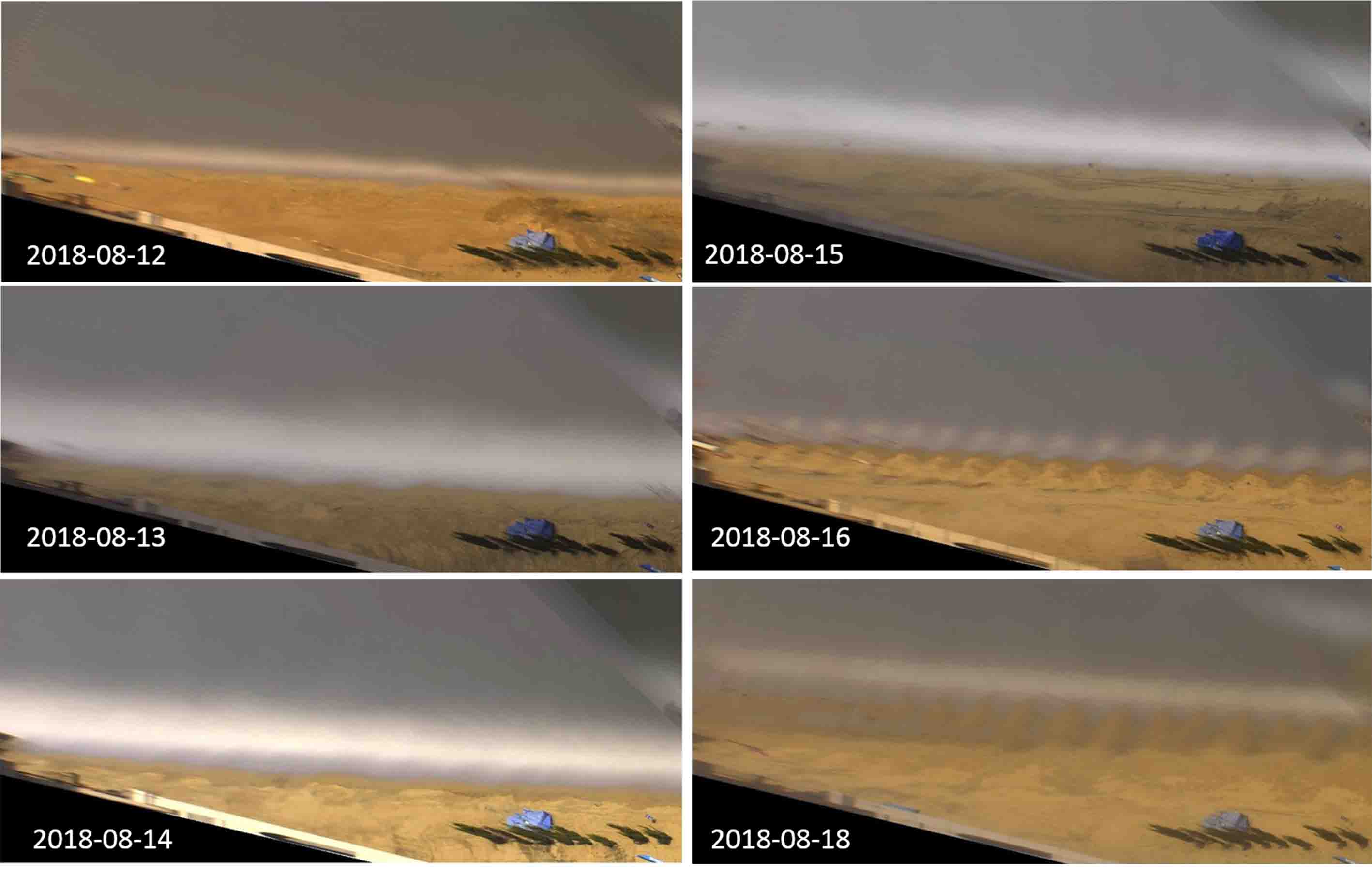
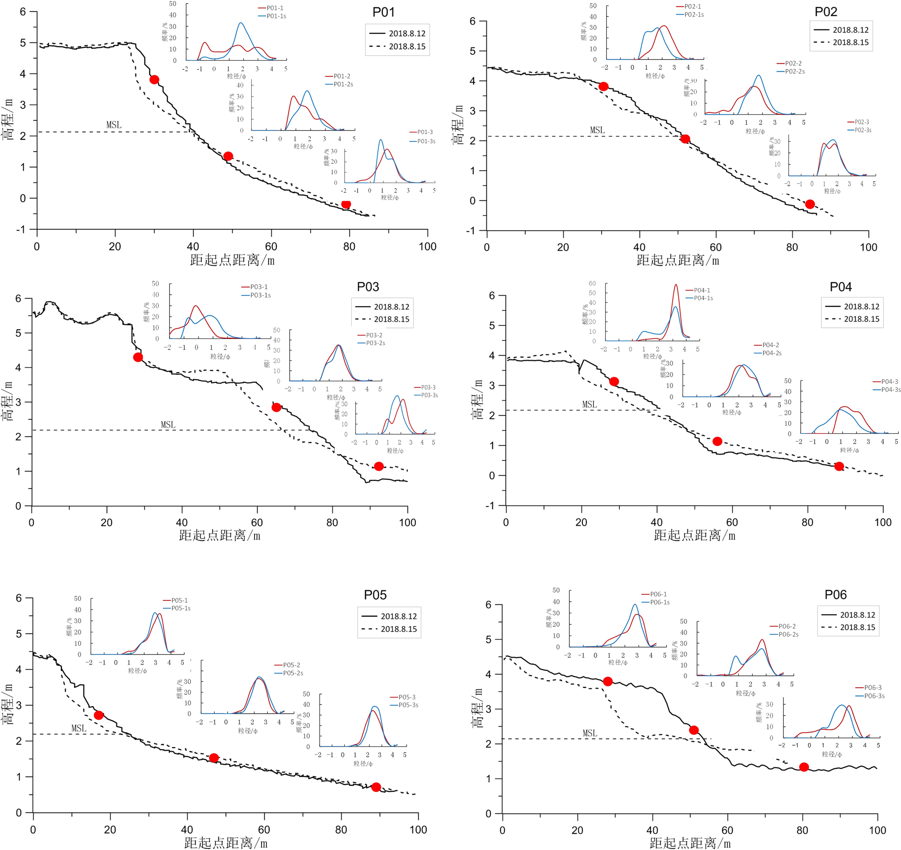
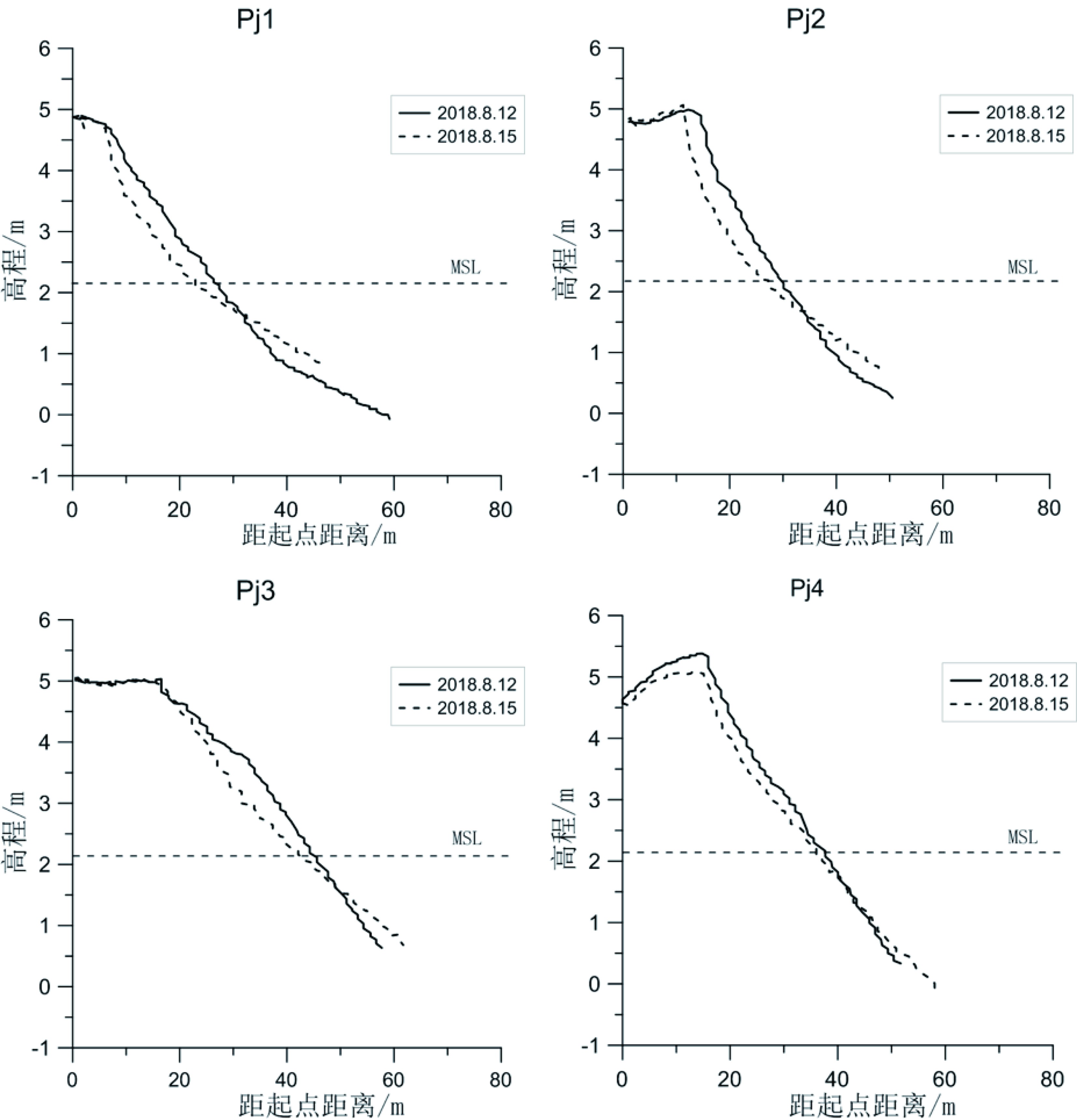
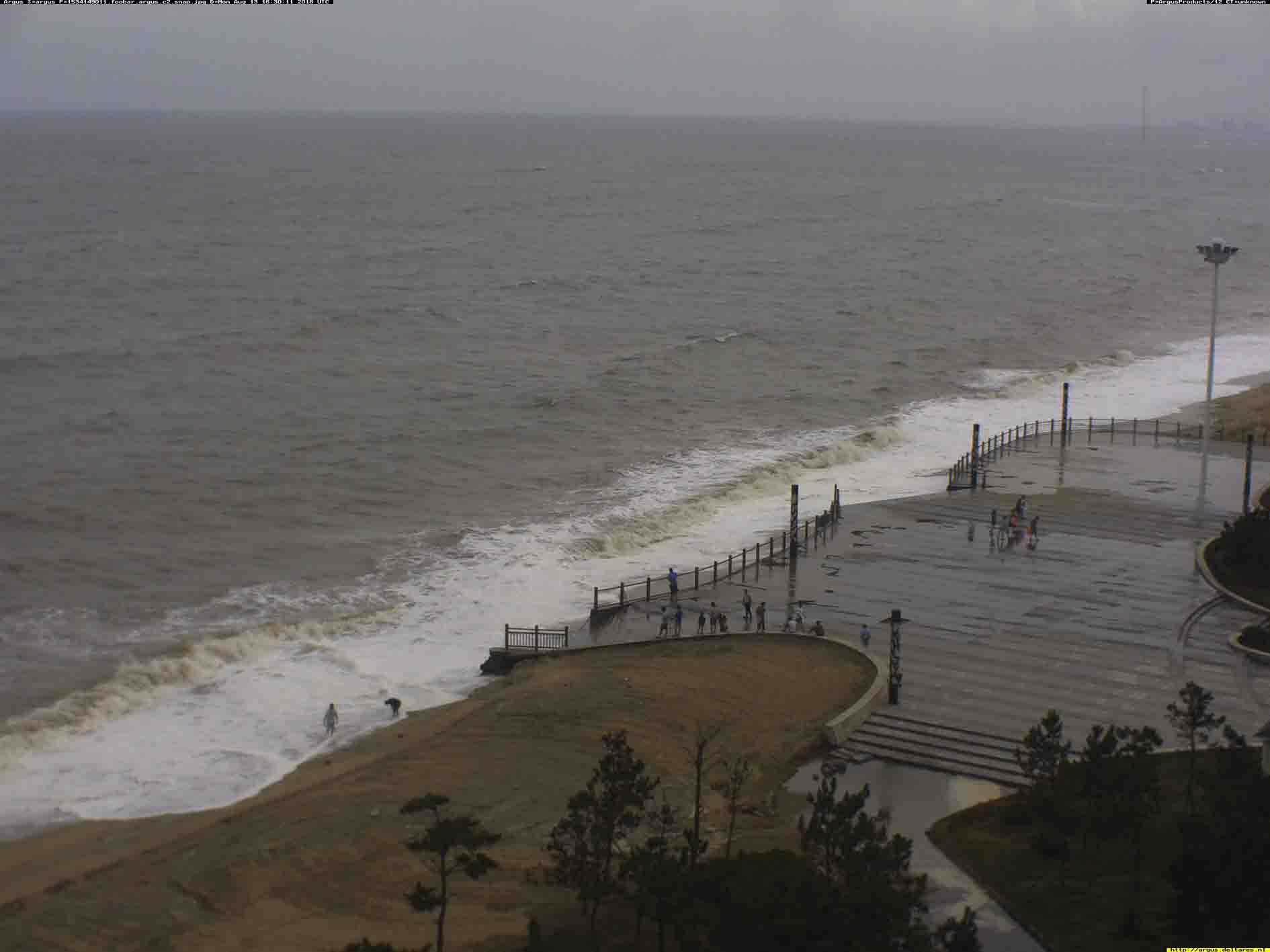
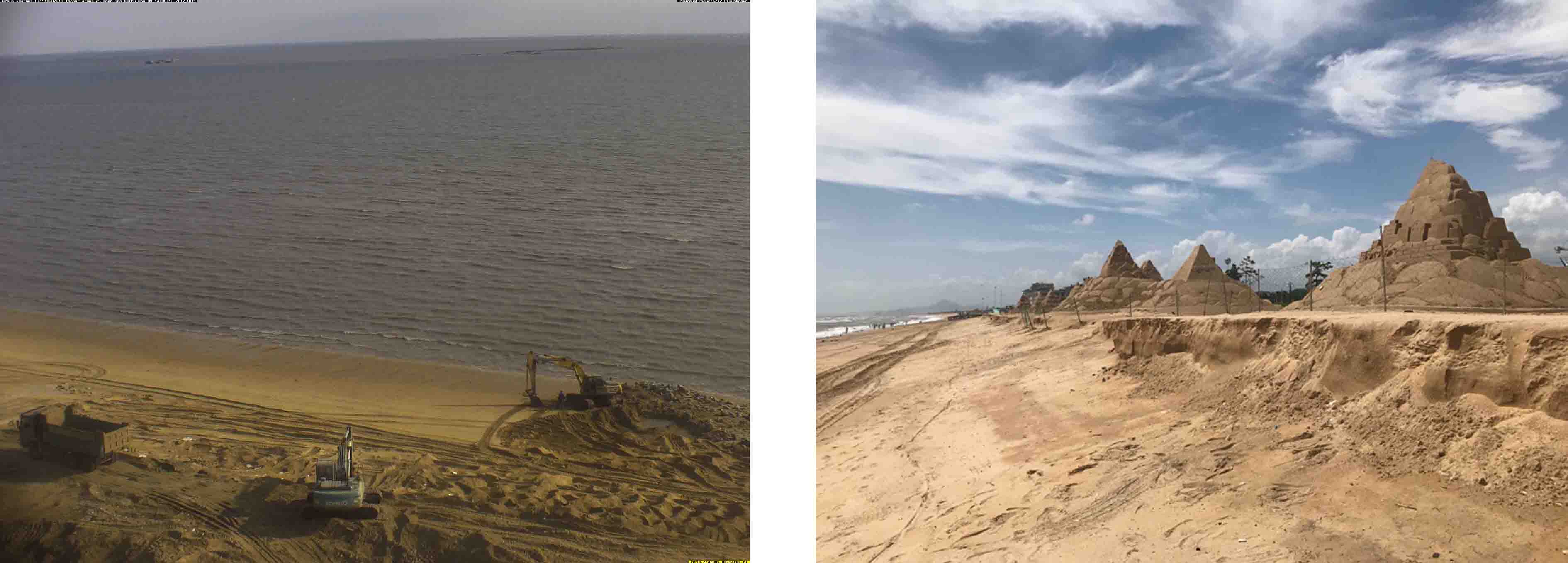
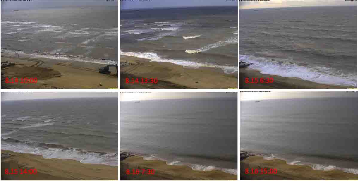
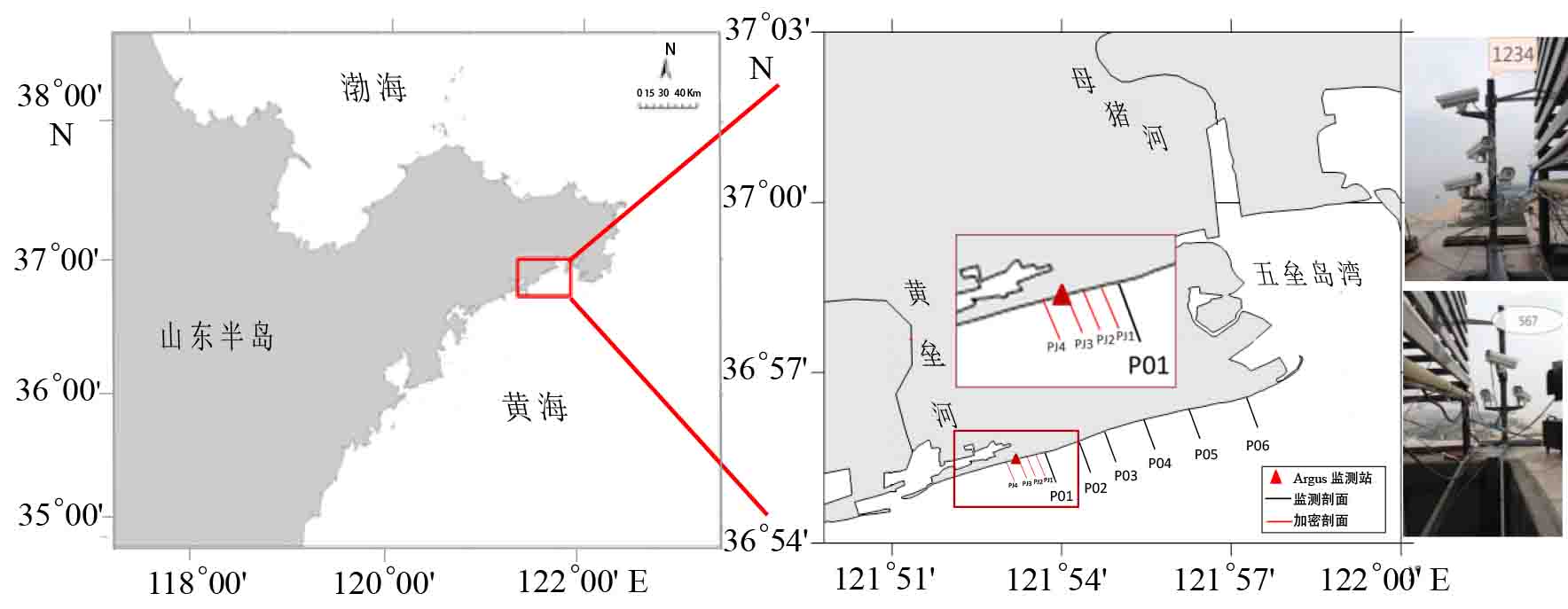
摘要: 综合分析2018年14号台风“摩羯”前后在山东省文登市南海海滩获取的Argus监测站数字影像、海滩剖面地形重复测量和沉积物粒度分析结果,探讨研究海滩地貌和沉积物对台风的响应特征。在台风“摩羯”的影响下,海滩剖面整体呈现上部侵蚀、坡度变陡、平均粒径值变小、分选变好的趋势,而下部淤积、坡度变缓、平均粒径值变大、分选变差的趋势,岸线平均后退3.8 m。Argus数字影像连续观测数据显示台风期间波浪条件主导海岸线响应,且台风导致的强浪破碎后波能在海滩的不均匀耗散使台风后海滩发育韵律性地貌—滩角。Abstract: Integrated analysis is carried out on the video images from the Argus monitoring station, topographic measurements from beach profiles and sediment particle size parameters obtained from the Nanhai Beach in Wendeng City, Shandong Province before and after the 14th Typhoon “Yagi” in 2018. Under the action of the typhoon, the upper part of the beach was eroded, the slope became steeper, the mean grain size decreased, and the sorting of sediments improved, whereas the lower part of the beach was depositional, the slope became gentler, particles coarsened, the sorting of sediments was getting poorer, and the shoreline receded for an average of 3.8 m. The Argus continuous observation video image data further suggests that under the action of typhoon, wave dominated the response of coastline and the cusp beach will develop in a rhythmic manner resulted from the uneven dissipation of wave energy on the beach after the breaking of strong waves caused by typhoon.
-
Keywords:
- typhoon /
- sandy coast /
- beach response /
- Argus /
- Wendeng city
-
-
表 1 台风前后海滩剖面特征变化
Table 1 Characteristics of beach profile before and after typhoon
坡度/(°) 高滩UED(m3/m) 中滩UED(m3/m) 低滩UED(m3/m) 岸线变化/m 陡坎变化/m 陡坎高程/m P01 9.9 2.13 −10.36 6.49 −1.09 −2.24 0.05 P02 4.7 3.25 −10.20 17.24 −2.3 −4.3 0.2 P03 5.4 10.77 −16.15 6.23 −7.6 −7.71 0.28 P04 4.5 2.56 −9.6 8.79 −4.7 −4.8 0.29 P05 5.0 0.4 −1.55 6.15 −2.2 −1.34 0.1 P06 7.2 1.66 −5.53 6.15 −3.6 −8.42 0.25 Pj1 7.6 0 −11.5 NA −3.45 −1.36 0.04 Pj2 7.2 0 −13.96 NA −2.41 −3.36 0.17 Pj3 6.0 0 −18.27 NA −2.18 −0.9 −0.02 Pj4 8.1 NA −6.66 NA −1.57 −0.73 −0.28 注:UED为单宽蚀积量数据,向海淤积为+,向陆后退为−;MSL位置变化和沙丘陡坎位置变化以向海方向移动为+,向陆方向移动为−,沙丘陡坎高程上升为+,下降为−。 表 2 台风前后海滩剖面粒度参数统计
Table 2 Statistics on grain size parameters on beach profiles before and after the typhoon
潮区 时间 平均粒径/ϕ 分选系数 粗砂含量/% 中砂含量/% 细砂含量/% 海滩下部 台风前 1.97 0.88 20.52 18.48 57.36 台风后 2.08 0.74 13.78 30.18 53.55 海滩中部 台风前 1.78 0.97 18.29 33.62 42.61 台风后 1.93 0.75 14.77 37.23 45.35 海滩上部 台风前 1.54 0.84 30.58 35.51 32.6 台风后 1.64 0.7 23.5 44.05 30.89 -
[1] Scott T, Masselink G, O'Hare T, et al. The extreme 2013/2014 winter storms: Beach recovery along the southwest coast of England [J]. Marine Geology, 2016, 382: 224-241. doi: 10.1016/j.margeo.2016.10.011
[2] Aubrey D G. Seasonal patterns of onshore/offshore sediment movement [J]. Journal of Geophysical Research: Oceans, 1979, 84(C10): 6347-6354. doi: 10.1029/JC084iC10p06347
[3] Wright L D, Short A D. Morphodynamic variability of surf zones and beaches: a synthesis [J]. Marine Geology, 1984, 56(1-4): 93-118. doi: 10.1016/0025-3227(84)90008-2
[4] Splinter K D, Kearney E T, Turner I L. Drivers of alongshore variable dune erosion during a storm event: observations and modelling [J]. Coastal Engineering, 2018, 131: 31-41. doi: 10.1016/j.coastaleng.2017.10.011
[5] 任美锷, 张忍顺, 杨巨海, 等. 风暴潮对淤泥质海岸的影响—以江苏省淤泥质海岸为例[J]. 海洋地质与第四纪地质, 1983(04):3-26. [Meie R, Renshun Z, Juhai Y. The influence of storm tide on mud plain coast—with special reference to Jiangsu province [J]. Marine Geology & Quaternary Geology, 1983(04): 3-26. [6] Otvos E G. Beach aggradation following hurricane landfall: impact comparisons from two contrasting hurricanes, Northern Gulf of Mexico [J]. Journal of Coastal Research, 2004, 20(1): 326-339.
[7] Qi H S, Cai F, Lei G, et al. The response of three main beach types to tropical storms in South China [J]. Marine Geology, 2010, 275(1-4): 244-254. doi: 10.1016/j.margeo.2010.06.005
[8] Puig M, Del Río L, Plomaritis T A, et al. Contribution of storms to shoreline changes in mesotidal dissipative beaches: case study in the Gulf of Cádiz (SW Spain) [J]. Natural Hazards and Earth System Sciences, 2016, 16(12): 2543-2557. doi: 10.5194/nhess-16-2543-2016
[9] 蔡锋, 雷刚, 苏贤泽, 等. 台风“艾利”对福建沙质海滩影响过程研究[J]. 海洋工程, 2006, 24(1):98-109. [CAI Feng, LEI Gang, SU Xianze, et al. Study on process response of Fujian beach geomorphology to typhoon Aere [J]. The Ocean Engineering, 2006, 24(1): 98-109. doi: 10.3969/j.issn.1005-9865.2006.01.016 [10] 陈子燊. 弧形海岸海滩地貌对台风大浪的响应特征[J]. 科学通报, 1996, 41(12):1015-1019. [CHEN Zishen. Response characteristics of beach morphologies in an arc-shaped coast to typhoon waves [J]. Chinese Science Bulletin, 1996, 41(12): 1015-1019. [11] 郭俊丽, 时连强, 童宵岭, 等. 浙江朱家尖岛东沙海滩对热带风暴"娜基莉"的响应及风暴后的恢复[J]. 海洋学报, 2018, 40(9):137-147. [GUO Junli, SHI Lianqiang, TONG Xiaoling, et al. The response to tropical storm Nakri and the restoration of Dongsha Beach in Zhujiajian Island, Zhejiang Province [J]. Haiyang Xuebao, 2018, 40(9): 137-147. [12] Holland K T, Holman R A, Lippmann T C, et al. Practical use of video imagery in nearshore oceanographic field studies [J]. IEEE Journal of Oceanic Engineering, 1997, 22(1): 81-92. doi: 10.1109/48.557542
[13] Armaroli C, Ciavola P, Balouin Y, et al. An integrated study of shoreline variability using Gis and ARGUS techniques [J]. Journal of Coastal Research, 2006, SI(39): 473-477.
[14] 中国海湾志编纂委员会. 中国海湾志: 第三分册(山东半岛北部和东部海湾)[M]. 北京: 海洋出版社, 1991: 241-469. China Bays Compling Committee. Encyclopedia of China Bays: Volume III [M]. Beijing: Ocean Press, 1991: 241-469.
[15] 杨继超, 宫立新, 李广雪, 等. 山东威海滨海沙滩动力地貌特征[J]. 中国海洋大学学报, 2012, 42(12):107-114. [YANG Jichao, GONG Lixin, LI Guangxue, et al. Morphodynamic feature on the beaches in Weihai, Shandong Province [J]. Periodical of Ocean University of China, 2012, 42(12): 107-114. [16] Holman R A, Stanley J. The history and technical capabilities of Argus [J]. Coastal Engineering, 2007, 54(6-7): 477-491. doi: 10.1016/j.coastaleng.2007.01.003
[17] Van Enckevort I M J, Ruessink B G. Effect of hydrodynamics and bathymetry on video estimates of nearshore sandbar position [J]. Journal of Geophysical Research: Oceans, 2001, 106(C8): 16969-16979. doi: 10.1029/1999JC000167
[18] Ranasinghe R, Symonds G, Black K, et al. Morphodynamics of intermediate beaches: a video imaging and numerical modelling study [J]. Coastal Engineering, 2004, 51(7): 629-655. doi: 10.1016/j.coastaleng.2004.07.018
[19] 刘海江, 时连强. 海岸带实时实地视频观测ARGUS技术[J]. 海洋工程, 2016, 34(2):80-87. [LIU Haijiang, SHI Lianqiang. Nearshore real-time in-situ video monitoring technique-the ARGUS system [J]. The Ocean Engineering, 2016, 34(2): 80-87. [20] Folk R L, Ward W C. Brazos River bar: a study in the significance of grain size parameters [J]. Journal of Sedimentary Research, 1957, 27(1): 3-26. doi: 10.1306/74D70646-2B21-11D7-8648000102C1865D
[21] Dolan R, Hayden B P, Heywood J. The reliability of shoreline change measurements from aerial photographs [J]. Shore and Beach, 1980, 48(4): 22-29.
[22] Angnuureng D B, Almar R, Senechal N, et al. Shoreline resilience to individual storms and storm clusters on a meso-macrotidal barred beach [J]. Geomorphology, 2017, 290: 265-276. doi: 10.1016/j.geomorph.2017.04.007
[23] Aarninkhof S G J, Turner I L, Dronkers T D T, et al. A video-based technique for mapping intertidal beach bathymetry [J]. Coastal Engineering, 2003, 49(4): 275-289. doi: 10.1016/S0378-3839(03)00064-4
[24] Guza R T, Inman D L. Edge waves and beach cusps [J]. Journal of Geophysical Research, 1975, 80(21): 2997-3012. doi: 10.1029/JC080i021p02997
[25] Werner B T, Fink T M. Beach cusps as self-organized patterns [J]. Science, 1993, 260(5110): 968-971. doi: 10.1126/science.260.5110.968
[26] 李志强, 陈子燊. 两种滩角成因假说的实证分析[J]. 热带海洋学报, 2008, 27(2):12-17. [LI Zhiqiang, CHEN Zishen. Comparing two dominating hypotheses about beach cusp formation with measured data [J]. Journal of Tropical Oceanography, 2008, 27(2): 12-17. doi: 10.3969/j.issn.1009-5470.2008.02.003


 下载:
下载:
