
A comparative study on the Late Quaternary stratigraphic architecture and formation of megadeltas in East and South Asia
-
摘要: 通过整理东亚、南亚典型河口三角洲末次冰消期以来演化历史的研究进展,对比各河口晚第四纪地层结构、沉积体系演替和三角洲开始建造的时间,分析其沉积历史的主要控制因素。结果显示,末次冰消期以来各河口具相似的地层结构和演变过程,即早全新世下切古河谷充填和河口湾发育,中—晚全新世三角洲建造,该过程主要受海平面变化的控制。但是各河口地层结构和沉积历史也存在差异,其中以三角洲开始建造的时间差别最为明显。对比发现这种差异与流域地貌、基岩以及河口沉积盆地的差别有关。流程短、流域基岩易侵蚀的河流,入海泥沙量大,其三角洲开始建造的时间显著早于其他河流,其中以恒河三角洲最为典型。另外,以珠江三角洲为典型,其半封闭、基底浅的河口沉积盆地特征,也有助于中全新世湾顶三角洲的建造。Abstract: Based on the researches on the evolution of megadeltas in East and South Asia since last deglaciation, we carried out a comparative study on the Late Quaternary stratigraphic architecture, sedimentary systems and the initiation time of megadeltas at large river mouths of the region. Major control factors on deltaic evolution are revealed and discussed. Our data suggests that all the river mouths in the region seem having experienced similar evolutionary history, including the infilling of incised palaeo-valleys and estuaries in Early Holocene, and deltaic progradation in Middle to Late Holocene, controlled by the sea-level change. However, there are some differences in the stratigraphic architecture and sedimentary history from river to river. The most remarkable difference is the time of delta initiation, which is related to the geomorphology and geology of the drainage basin and the sedimentary basin at river mouths. Those rivers having short flow paths and erosive bedrocks in the drainage basin, such as the Ganges-Brahmaputra, usually produce a huge amount of sediment load. As a result, the time of the delta initiation was obviously earlier than other rivers. The Pearl River delta is another example. It has a semi-closed shallow sedimentary basin which is beneficial to the formation of delta in the Middle Holocene.
-
Keywords:
- sedimentary system /
- delta initiation /
- sea level /
- sediment load /
- sedimentary basin
-
在有人类历史记载以来,气候变化模式与人类活动的相互作用备受关注。比如最受人们关注的中世纪暖期和小冰期等时期的温度和水文变化,无数科学家已进行了大量的研究,但在区域空间变化特征和动力机制等方面,目前仍然是国内外学者讨论的焦点[1-3]。已有的研究表明,热带辐合带的南北移动[4-5]、海陆热力差异[6]和ENSO活动的强弱[7]等,是影响亚洲季风区和热带区域千年以来不同降雨格局的主要因素[7-9],但亚洲季风动力学复杂的控制过程和多变的内在机制使得上述观点仍存在争议,尤其是类厄尔尼诺和类拉尼娜现象对中国北方、南方、东南亚和西太平洋等不同区域降雨时空模式的影响存在诸多的不确定性[6-7,10-12]。
历史时期,这些不同的气候条件直接影响了区域的生态系统、农业发展、人口密度、人口迁徙和文明演变[13-16];而另外一方面,在某些情况下,强烈的人类活动也可能会影响环境的变化,导致水土流失、土地荒漠化[17-19]以及沙尘暴频发等恶劣气候的出现[20]。虽然区域内气候变化与人类活动关系的探究已屡见不鲜,但二者之间的响应在宏观地理尺度上的联系仍知之甚少。
本文选择西沙群岛的东岛牛塘湖泊近1 000年以来的沉积物,以珊瑚砂粒度组分含量和环境磁学参数为替代指标,讨论热带区域百年时间尺度的降雨变化和可能的人类活动历史,并通过对比中国北方近千年以来的强沙尘暴记录,探讨中国北方粉尘事件传输至低纬度区域的可能性及其区域气候响应特征。
1. 研究材料与方法
1.1 采样位置与样品描述
东岛(16°39′~16°41′N、12°43′~112°45′E)位于西沙群岛东部(图1),是一长椭圆形的热带珊瑚岛屿,发育在独立的礁盘上,大约形成于全新世晚期,海拔3~6 m。东岛四周高,中间低,其东、南、西部均被沙堤包围,沙堤高约6 m;沙堤之内是平坦的盆地,海拔约3 m。牛塘是东岛内部一个长约120 m、最宽约20 m的淡水湖,位于岛的西南侧,距离海边的沙堤约120 m[21]。
![]() 图 1 西沙群岛、采样钻孔及公海湖位置a. 西沙群岛以及公海湖的位置(黑色方框为西沙群岛的位置,红色圆点为公海湖的位置); b. 东岛的位置(黄色方框为牛塘湖泊的位置); c. 钻孔位置(黄色虚线为牛塘湖泊大体边界,红色方块为钻孔位置)。Figure 1. Map of Xisha Islands and Gonghai Lake showing the location of the boreholesa. The location of Xisha Islands and Gonghai Lake (the black box is the location of Xisha Islands and the red dot is the location of Gonghai Lake); b. The location of the Dongdao Island (the yellow box is the location of Cattle Pond); c. Borehole location (the yellow dotted line is the boundary of Cattle Pond, the red square is the drilling location).
图 1 西沙群岛、采样钻孔及公海湖位置a. 西沙群岛以及公海湖的位置(黑色方框为西沙群岛的位置,红色圆点为公海湖的位置); b. 东岛的位置(黄色方框为牛塘湖泊的位置); c. 钻孔位置(黄色虚线为牛塘湖泊大体边界,红色方块为钻孔位置)。Figure 1. Map of Xisha Islands and Gonghai Lake showing the location of the boreholesa. The location of Xisha Islands and Gonghai Lake (the black box is the location of Xisha Islands and the red dot is the location of Gonghai Lake); b. The location of the Dongdao Island (the yellow box is the location of Cattle Pond); c. Borehole location (the yellow dotted line is the boundary of Cattle Pond, the red square is the drilling location).2018年在牛塘湖泊的东南部以重力活塞取样的方式钻取了3条长约80 cm的钻孔(图1),编号分别为DD、DD-1和 DD-2,本文主要研究钻孔DD-1。钻孔顶部约5 cm的沉积被严重扰动,取样时没有保存。钻孔整体岩性为珊瑚砂,顶部为浅灰色至灰褐色的黏土质珊瑚较粗砂,含动物粪便纤维、植物残体以及微体生物,中部为浅灰褐色细粒砂质沉积物,底部为淡黄色较粗粒砂质沉积物,含白色珊瑚、贝壳碎屑较多。
1.2 实验方法
对DD-1钻孔以0.5 cm为间隔进行连续取样,共采取样品124个。从每个样品中取2 g左右用聚乙烯保鲜膜包裹,置于规格为2 cm×2 cm×2 cm的无磁性塑料盒中,压实固定后用于磁学参数测量;同时采取平行样品冷冻干燥,充分分散之后进行沉积物粒度测试。
对所有盒装样品进行如下环境磁学实验。首先在卡帕桥MFK1-FA磁化率仪进行高、低频磁化率测试,测试频率分别为15 616和976 Hz,场强为200 A/m。对测量完磁化率的所有样品,施加80 mT的交变场和0.05 mT的直流场,测量非磁滞剩磁(ARM);之后,对样品分别施加1000、–100和 –300 mT的脉冲场,测量相应的等温剩磁(IRM),两项实验均利用2G-760 超导磁力仪测量。1000 mT场强时的剩磁视为饱和等温剩磁(SIRM)。用(SIRM+IRM−300mT)/2计算得到HIRM, 一般表示样品中赤铁矿的含量,S300=(IRM−300mT/SIRM)一般表示样品中高矫顽力矿物的相对含量(IRM−300mT指的是−300 mT时的剩磁),ARM/SIRM表示磁性矿物粒度的相对大小。根据SIRM的变化,分别选择其高、低值处的代表性样品进行磁滞回线以及磁化率随温度变化的实验,识别磁性矿物的类型。磁滞回线在MicroMag3900 振动磁强计完成,最大磁场为1 T。磁化率随温度变化实验在MFK1-FA磁化率仪完成,温度区间为室温至700 °C。
采用振动筛析法对样品进行粒度分析。将冻干分散后的样品置于分析筛上,充分振荡进行筛分。筛子直径分别为5、2、1、0.5、0.25、0.125、0.063 mm,分别对筛分后各个粒级的物质进行称重。
ARM和IRM实验在中国地质大学(武汉)古地磁实验室完成,其他实验在中山大学地球科学与工程学院磁学实验室进行。
2. 钻孔沉积物年代框架
在3个钻孔中挑选粒径>0.125 mm的底栖有孔虫、植物种子和贝壳共20个样品,加入500 μL乙醇放置在超声波振荡仪中清洗30 s,并用纯水清洗之后,送往Beta实验室进行AMS 14C测年,测量结果见表1。测年数据用Calib 704软件校正至日历年龄,由于东岛“牛塘”为淡水湖泊,校正曲线采用Intcal 13。
表 1 DD-1、DD-2和DD钻孔样品AMS 14C年龄测定结果Table 1. AMS 14C dating results of core DD-1, DD-2 and DD钻孔 样品编号 实验室编号 深度/cm 材料 常规年龄/aBP 校正年龄/(2σ,cal aAD) DD-1 DD-1018 521063 10 有孔虫 300± 30 1490—1602 DD-1039 513103 21.5 有孔虫 900 ± 30 1115—1210 DD-1072 513104 36 贝壳 720 ± 30 1246—1302 DD-1074 546086 40.5 有孔虫 900 ± 30 1115—1210 DD-1080 546088 43.5 有孔虫 880 ± 30 1117—1221 DD-1086 521064 46.5 有孔虫 960 ± 30 1063—1154 DD-1086 546089 46.5 有孔虫 970 ± 30 1063—1154 DD-1093 546090 50 有孔虫 700 ± 30 1262—1308 DD-1114 513105 57 贝壳 980 ± 30 1075—1154 DD-1117 513106 62 有孔虫 990 ± 30 989—1052 DD-1120 517595 63.5 有孔虫 990 ± 30 989—1052 DD-2 DD-286.5 546096 36.5 有孔虫 940 ± 30 1026—1158 DD-260.5 546095 49 种子 720 ± 30 1246—1302 DD-221-2 546094 69 有孔虫 1450 ± 30 561—651 DD-221 546093 69 种子 960 ± 30 1063—1154 DD-24.5 546092 77.5 种子 1130 ± 30 860—998 DD DD 121 513108 5 有孔虫 340 ± 30 1470—1639 DD 61.5 546098 34.75 种子 690 ± 30 1226—1312 DD 37 546097 47 种子 880 ± 30 1117—1221 DD 017 513107 57 有孔虫 1600 ± 30 400—538 由表1可见,3个钻孔的测量年龄均存在倒转现象,甚至同一层位植物种子和有孔虫的年龄也存在很大差异。为建立可靠的沉积物年龄模式,首先基于沉积物岩性和磁化率的变化,对3个钻孔进行对比,确定不同钻孔沉积物的对比方案,然后对3个钻孔的年龄进行综合分析,挑选合适的测年数据进行年龄框架的重建。3个钻孔为相邻的平行钻孔,岩性变化代表了相同的沉积过程,而磁化率的相对大小变化是岩性变化的良好反映。以显著的岩性变化为标志、以磁化率值的高、低变化为可对比层位,建立3个钻孔沉积物的分布模式(图2)。根据3个钻孔磁化率的对比,DD-1钻孔21.5 cm和50 cm两个层位的测量数据900±30 a、700±30 a应该为异常数据,在建立年龄模式时删除。根据前人对在同一湖泊沉积顶部210Pb的测量结果,顶部约13 cm的沉积年代为1861—2003年,约20~21 cm处的AMS14C年龄为1476—1661AD(2 sigma)[22]。可能由于打钻过程中的压实作用,DD-1钻孔在约10 cm处的AMS14C测年结果与前人在20~21 cm处的基本相同,沉积厚度减小一半,估算近100年来的沉积可能只有约5~6 cm厚。而在打钻的过程中顶部约5 cm的样品由于扰动未取样,故无法对沉积钻孔顶部进行年龄限定。对DD-1钻孔其他数据,使用基于R语言的Bacon程序建立年龄-深度模型(图3)[23]。
![]() 图 2 3条钻孔岩性和磁化率对比绿色数字为异常年龄点,红色数字为正常测定年龄;红色虚线代表3条钻孔对应的沉积层位。Figure 2. Comparison of lithology and magnetic susceptibility of core DD-1, DD-2 and DDThe red numbers represent the normal ages while the green numbers represent the uncertain ages; The red dotted lines show the correlation depositional horizons among three boreholes.
图 2 3条钻孔岩性和磁化率对比绿色数字为异常年龄点,红色数字为正常测定年龄;红色虚线代表3条钻孔对应的沉积层位。Figure 2. Comparison of lithology and magnetic susceptibility of core DD-1, DD-2 and DDThe red numbers represent the normal ages while the green numbers represent the uncertain ages; The red dotted lines show the correlation depositional horizons among three boreholes.![]() 图 3 牛塘湖泊沉积DD-1柱状样年龄-深度模型实线代表平均年龄,左侧虚线代表最小年龄,右侧虚线代表最大年龄,三角形点代表校正后的测量数据,三角形点所在的线代表年龄误差。Figure 3. Age-Depth model of borehole in Cattle PondThe solid line represents the mean age; The left and right dotted lines represent the minimum and the maximum age respectively; The triangle symbols represent the calibrated AMS14C ages, and the line on the triangle represents the age error.
图 3 牛塘湖泊沉积DD-1柱状样年龄-深度模型实线代表平均年龄,左侧虚线代表最小年龄,右侧虚线代表最大年龄,三角形点代表校正后的测量数据,三角形点所在的线代表年龄误差。Figure 3. Age-Depth model of borehole in Cattle PondThe solid line represents the mean age; The left and right dotted lines represent the minimum and the maximum age respectively; The triangle symbols represent the calibrated AMS14C ages, and the line on the triangle represents the age error.3. 实验结果
3.1 沉积物粒度分布及湖泊水动力条件变化
沉积物颗粒物质主要为珊瑚砂,含有介形虫和有孔虫等微体生物。通过体视显微镜观察,当有机质含量高时,微体生物含量低,而当珊瑚砂等含量高时,微体生物的含量也相对增加,其在珊瑚砂中的占比基本不变。从测试结果可见(图4),沉积物主要为1~0.063 mm的珊瑚砂(平均含量约81%),仅有个别样品存在>5 mm的成分,<0.063 mm的珊瑚砂含量低于25%。5~0.125和<0.063 mm两个端元的组分呈相反的变化趋势,代表了两种不同的水动力条件。前者表示水动力条件较大,后者表示水动力条件较小。水动力条件的变化可以分为3个过程,即公元1000—1100、1100—1400年和1400年之后,水动力从强-弱-较强的变化。
![]() 图 4 钻孔沉积物粒度组分变化灰色阴影表示水动力条件较强。Figure 4. The fraction variations of the different grain particle size of the borehole sedimentsThe gray bar marked the stronger hydrodynamics condition.
图 4 钻孔沉积物粒度组分变化灰色阴影表示水动力条件较强。Figure 4. The fraction variations of the different grain particle size of the borehole sedimentsThe gray bar marked the stronger hydrodynamics condition.3.2 磁性参数与碎屑物质输入量变化
典型样品的磁滞回线结果表明,沉积物中磁性矿物类型的变化分为两大类(图5)。第一种类型的沉积物具有软磁性物质主导的磁滞回线特征,在200 mT时可以达到闭合,矫顽力(Bc)为9~17 mT,这种类型的沉积物具有较高的SIRM值;而另一种类型为抗磁性物质主导,饱和磁化强度(Mr)为负值,这种类型的沉积物具有很低的SIRM值。平行样品的磁化率随温度变化曲线进一步表明,对第一种类型的沉积物,加热曲线的磁化率在约585 °C有明显的快速衰减,表明了磁铁矿的存在。两种类型的沉积物(顶部具有最高SIRM值的沉积物除外)加热曲线在200~400 °C之间随温度升高磁化率均显著下降,有可能是样品中的抗磁性物质随温度变化对磁化率的影响加大,但不能排除沉积物中可能含有磁赤铁矿。冷却曲线在约585 °C有明显的升高,之后变化相对平缓,其值低于初始磁化率值,或者基本相等,表明在加热过程中没有明显的新的磁铁矿产生,样品中磁铁矿的信息应该来自原始沉积物。
非磁滞剩磁(ARM)和饱和等温剩磁(SIRM)表示沉积物中磁性矿物浓度的变化,前者对稳定单畴的细粒物质更为敏感[24]。柱状剖面中,磁性参数最显著的变化在约1600 AD 之后,SIRM和HIRM比前期高两个数量级以上,显示磁性矿物浓度的快速增加;S300比值保持在0.9以上,没有明显的降低,ARM/SIRM减小,表示磁性矿物的类型没有发生大的变化[25],粒度有所变粗[26]。SIRM另一比较明显的较高值发生在1120—1250 AD,同样ARM/SIRM也减小。这两处磁性参数明显变化的时期,反映了陆源的碎屑物质输入量增加,与中国历史文献记录中强风尘天气发生频次较高的记录一致[27],该时期伴随着湖泊粗颗粒物质的减小。整个钻孔中沉积物(SIRM+IRM-100mT)/SIRM与HIRM/SIRM呈现基本一致的趋势,表明沉积物中矫顽力大于100 mT的磁性矿物主要是高矫顽力矿物(图6)。
![]() 图 6 沉积物环境磁学参数随时间变化特征点线为原始数据,折线为5点滑动平均数据,灰色阴影表示陆源碎屑输入增加。Figure 6. Environmental magnetic proxies variations along with the age profileThe dots and line represent the original data, and broken lines display the 5-point adjacent average smoothing data; the gray bar mark more terrigenous input.
图 6 沉积物环境磁学参数随时间变化特征点线为原始数据,折线为5点滑动平均数据,灰色阴影表示陆源碎屑输入增加。Figure 6. Environmental magnetic proxies variations along with the age profileThe dots and line represent the original data, and broken lines display the 5-point adjacent average smoothing data; the gray bar mark more terrigenous input.4. 讨论
4.1 过去近千年西沙群岛降雨与季风气候的反向变化
一般情况下,封闭性湖泊的沉积物粒度能够反映湖泊水位的上升或下降,粒度越细表示湖泊水位越高[28]。但是牛塘湖泊位于珊瑚礁之上,湖泊四周为珊瑚砂,具有较高的孔隙度,水体易与海水之间相互渗透,使得牛塘的水位持续保持在0.5 m左右的状态[21],湖泊沉积物的粒度可能并不反映湖泊水位的变化,而是表示将珊瑚砂从四周汇水面积区搬运至沉积区的水动力强度的大小[22,29]。在降雨期间,来自于沙堤的漫流将坡面及周边物质搬运至湖泊中沉积[22]。由于沙堤的阻隔,当海平面低于湖泊沙堤之下时,一般正常的海浪对湖泊的珊瑚砂不产生影响。同时,整个钻孔沉积物主要由白色的珊瑚砂组成,沉积物呈现贫有机质的特征,说明沙堤植被覆盖变化不大,对源区沉积物粒度变化的影响较小。整条钻孔中,沉积物中主要为1~0.063 mm的珊瑚砂,部分样品>0.5 mm百分含量非常低,部分样品无>1 mm的珊瑚砂,0.125~0.5 mm主要为珊瑚砂和微体生物壳体。由此可以认为排除微体生物壳体的影响之后,湖泊沉积物中颗粒珊瑚砂的含量(这里用0.125~0.5 mm的珊瑚砂含量表示),可以作为搬运水动力强弱的指标,其值越大,说明水动力较强,降雨量较大。而一些特别突然的粗颗粒含量沉积段(图4,这里用>5 mm表示),可能表示异常风暴潮等海洋因素对珊瑚砂的影响。
对比东岛湖泊沉积物粒度0.125~0.5 mm颗粒含量的变化,同一湖泊的介形虫壳体氧同位素和相邻的海南岛玛珥湖沉积物的粉砂物质含量(图7 a,b,c),可以发现近1000年以来,西沙群岛区域的热带降雨呈现3个阶段,即在约1000—1100年降雨较多(图7 A段),在1100—1400年降雨减少(图7 B段),而1400年之后是降雨最丰沛时期(图7 C段)。较多的降雨使湖泊之中介形类壳体的氧同位素偏轻。其中1000—1100年的降雨,强度和范围较小,没有持续向北传送至海南岛地区,湖泊之中的水体没有呈现明显的淡化。西沙群岛这一降雨特征与印度季风和东亚季风强度均呈现反向的变化[30]。1000—1100年是中世纪暖期中后期全球气温较高时期,西沙群岛降雨较多而亚洲季风区降雨较少,主要的驱动因素可能在于该时期为ENSO频发时期[31],其给热带和陆地季风区域带来了不同的降雨过程。在1100—1400年期间,ENSO活动减弱,热带辐合带的向北移动促使了季风的加强,使季风区域降雨增多而热带区域降雨减少。1400年之后,小冰期时期全球气温下降,ENSO活动较弱,热带辐合带回撤,季风减弱而热带区域降雨增加。热带和季风区域这种在百年尺度的空间降雨变化,表明不同的热带海洋过程对热带和季风区域的降雨变化有不同的模式,ENSO活动较强时,会在一定程度上抑制季风的强度。
![]() 图 7 西沙群岛东岛牛塘湖泊表示的热带降雨与季风气候对比a. 牛塘湖泊沉积物粒度,b. 牛塘湖泊介形虫壳体氧同位素[22],c. 海南岛双池岭玛珥湖沉积物粒度[32],d. 泰国Klang洞石笋氧同位素记录[33], e. 中国万象洞石笋氧同位素记录[30], f. 东太平洋加拉帕戈斯群岛El Junco湖砂记录[31]。年龄范围由4个全岩有机碳样品碳十四年龄测定限定。Figure 7. Correlation of tropical rainfall and monsoon climate in Cattle Pond, Dongdao Island, Xisha Islandsa. Grain size of sediments in Cattle Pond, b. Oxygen isotope of Ostracoda shells in Cattle Pond[22], c. Grain-size of sediments in Maar Lake, Shuangchiling, Hainan Island[32], d. Oxygen isotope records of stalagmite in Kiang Cave, Thailand[33], e. Oxygen isotope records of stalagmites from the Wanxiang Cave, China[30], f. El Junco sand record, Gala´pagos Islands, eastern tropical Pacific[31].The age range was restricted by AMS14C of four bulk sediment samples.
图 7 西沙群岛东岛牛塘湖泊表示的热带降雨与季风气候对比a. 牛塘湖泊沉积物粒度,b. 牛塘湖泊介形虫壳体氧同位素[22],c. 海南岛双池岭玛珥湖沉积物粒度[32],d. 泰国Klang洞石笋氧同位素记录[33], e. 中国万象洞石笋氧同位素记录[30], f. 东太平洋加拉帕戈斯群岛El Junco湖砂记录[31]。年龄范围由4个全岩有机碳样品碳十四年龄测定限定。Figure 7. Correlation of tropical rainfall and monsoon climate in Cattle Pond, Dongdao Island, Xisha Islandsa. Grain size of sediments in Cattle Pond, b. Oxygen isotope of Ostracoda shells in Cattle Pond[22], c. Grain-size of sediments in Maar Lake, Shuangchiling, Hainan Island[32], d. Oxygen isotope records of stalagmite in Kiang Cave, Thailand[33], e. Oxygen isotope records of stalagmites from the Wanxiang Cave, China[30], f. El Junco sand record, Gala´pagos Islands, eastern tropical Pacific[31].The age range was restricted by AMS14C of four bulk sediment samples.4.2 西沙群岛区域人类活动记录
1100—1200年SIRM值相对前后时期的增加(图5),表示陆源碎屑物质输入量的增加。由于其对应粗颗粒物质含量减少时期,由强烈的波浪运动输送海洋悬浮搬运碎屑物质的可能性较小。同时该时期处于夏季风较强时期,由季风搬运远源物质而使碎屑物质输入增多的贡献也不可能十分显著。较多的碎屑物质来源,应该反映了岛上近1 000年来早期较强的人类活动。南宋时期,我国经济重心已经移至江南地区,“南重北轻”的经济格局导致海上贸易的蓬勃发展,泉州、广州、温州等是海上贸易的重要港口,而南海又是古代“海上丝绸之路”贸易的必经之处,西沙群岛地处南海贸易航线[34-35],西沙群岛可能成为过往船只的重要休憩地。西沙华光礁一号沉船的考古工作,发现一大批产自南方地区的外销瓷器,说明华南沿海地区宋代以来制瓷手工业的兴盛和外向型生产特征[34-35],东岛牛塘人类活动的记录证明了海上丝绸之路在南宋的繁荣发展。
在1200年之后,随着元朝建立、海上贸易活动的减弱,西沙群岛人类活动也相对减弱。公元1600年以后,SIRM表示磁性矿物浓度急剧增加,沉积物中的有机质含量明显增高,反映了在该时期之后,岛上人类活动快速增加,可能与明代海上贸易的再次繁盛有关[36-37]。在西沙群岛北礁的水下考古调查中,发现了大量明代的文化遗址[38],证明了该时期西沙群岛是海上贸易的重要通道。此外,东岛至今留存着明朝时期渔民祭祀的祭坛[39]。同时,前人研究表明明末清初野牛被带入东岛以及对鸟粪进行开采用于农业[40],这些都证明了在明朝时期人类已经在西沙群岛活动。
4.3 北方沙尘暴事件在西沙群岛的记录
近些年来,众多学者探讨在中国北方频繁发生的沙尘暴事件和人类活动之间的关系。在地质历史记录中,部分学者利用东部黄土高原上湖泊沉积的粒度指标重建了过去近2000年的沙尘暴历史,表明在北宋末年至南宋以及明朝发生重大沙尘暴事件。他们认为沙尘暴发生在北方降雨相对丰沛时期,提出人类活动是该时期中国东部沙尘暴的主要控制因素[20]。
在牛塘湖泊的沉积物记录中,在1000—1200 AD和1450—1600 AD 期间,HIRM/SIRM呈现两次明显的波动(图8),表明碎屑物质中赤铁矿含量相对增多。在这两次事件发生时期,西沙地区降雨量较多,气候湿润,原地风化作用形成赤铁矿的贡献应该相对较小,相对更多含量的赤铁矿应该来源于外部的输入。从湖泊介形类的氧同位素值相对偏轻的特征分析,湖泊水体此时偏淡水,波浪作用引起的海水入侵可以忽略,相对更多含量的赤铁矿最大的来源应该是输入的粉尘中含量的变化,即HIRM/SIRM的两次波动,是北方同一时期沙尘暴事件在西沙地区的记录。
![]() 图 8 西沙东岛牛塘湖泊记录的两次北方沙尘暴事件a 牛塘湖泊沉积物粒度,b 公海湖泊沙尘暴记录[20],c 东岛粉尘记录指标(HIRM/SIRM)。灰色阴影表示两次沙尘暴发生的时期。Figure 8. Two dust storm events recorded in the lake deposits on Xisha Islandsa. Grain size of sediments in Cattle Pond, b. Dust storm record of Gonghai Lake[20],c. Dust record proxy of Dongdao Island (HIRM/SIRM). Gray bars represent the periods during which the two dust storms occurred.
图 8 西沙东岛牛塘湖泊记录的两次北方沙尘暴事件a 牛塘湖泊沉积物粒度,b 公海湖泊沙尘暴记录[20],c 东岛粉尘记录指标(HIRM/SIRM)。灰色阴影表示两次沙尘暴发生的时期。Figure 8. Two dust storm events recorded in the lake deposits on Xisha Islandsa. Grain size of sediments in Cattle Pond, b. Dust storm record of Gonghai Lake[20],c. Dust record proxy of Dongdao Island (HIRM/SIRM). Gray bars represent the periods during which the two dust storms occurred.在北方沙尘暴发生时期,较细的粉尘物质经过空气对流,进入到对流层甚至平流层,随空气的流动而长距离的搬运。对流层低层850 hPa风场处于海拔1 200~1 900 m的高度上,是近地面摩擦层的界面,与地面之间有很强的相关性。850 hPa风场是粉尘物质远距离传输的关键层位[41]。前人通过对中国华南地区不同高度的水平风场进行合成分析,结果显示粉尘物质输送至中国东南沿海的风场是850 hPa风场[42]。当空气中的粉尘物质输送到西沙地区时,充足的水汽一方面有利于细颗粒的粉尘物质发生凝聚,同时粉尘物质也是大气颗粒物形成云凝结核、促使降雨形成的有利条件,两个方面的综合作用使粉尘物质随降雨进入到湖泊沉积之中。
5. 结论
(1)对位于西沙群岛东岛的牛塘湖泊钻取3根短柱状样品,通过AMS14C测年和基于岩性、磁化率变化的钻孔对比,建立钻孔地层公元1000—1700年间的年代框架。
(2)对湖泊沉积物高分辨率的粒度分析和环境磁学参数的测试结果分析表明,湖泊沉积物中0.125~0.5 mm珊瑚砂含量代表了该地区降雨量的变化,其反映的降雨规律与季风气候呈现相反的模式,即西沙地区降雨较多时,季风强度较弱。这种变化反映了ENSO活动和热带辐合带的移动对热带降雨和季风气候的综合作用结果。
(3)沉积物中环境磁学参数记录了岛上人类活动的历史,公元1100—1200年和1600年之后的两次磁性矿物浓度的显著增加,是南宋时期海上贸易活动繁荣和明末社会更替的反映;而1000—1200年和1450—1600年两次赤铁矿含量的相对增多,是北方强沙尘暴事件在西沙群岛的记录。
-
![]()
![]()
![]()
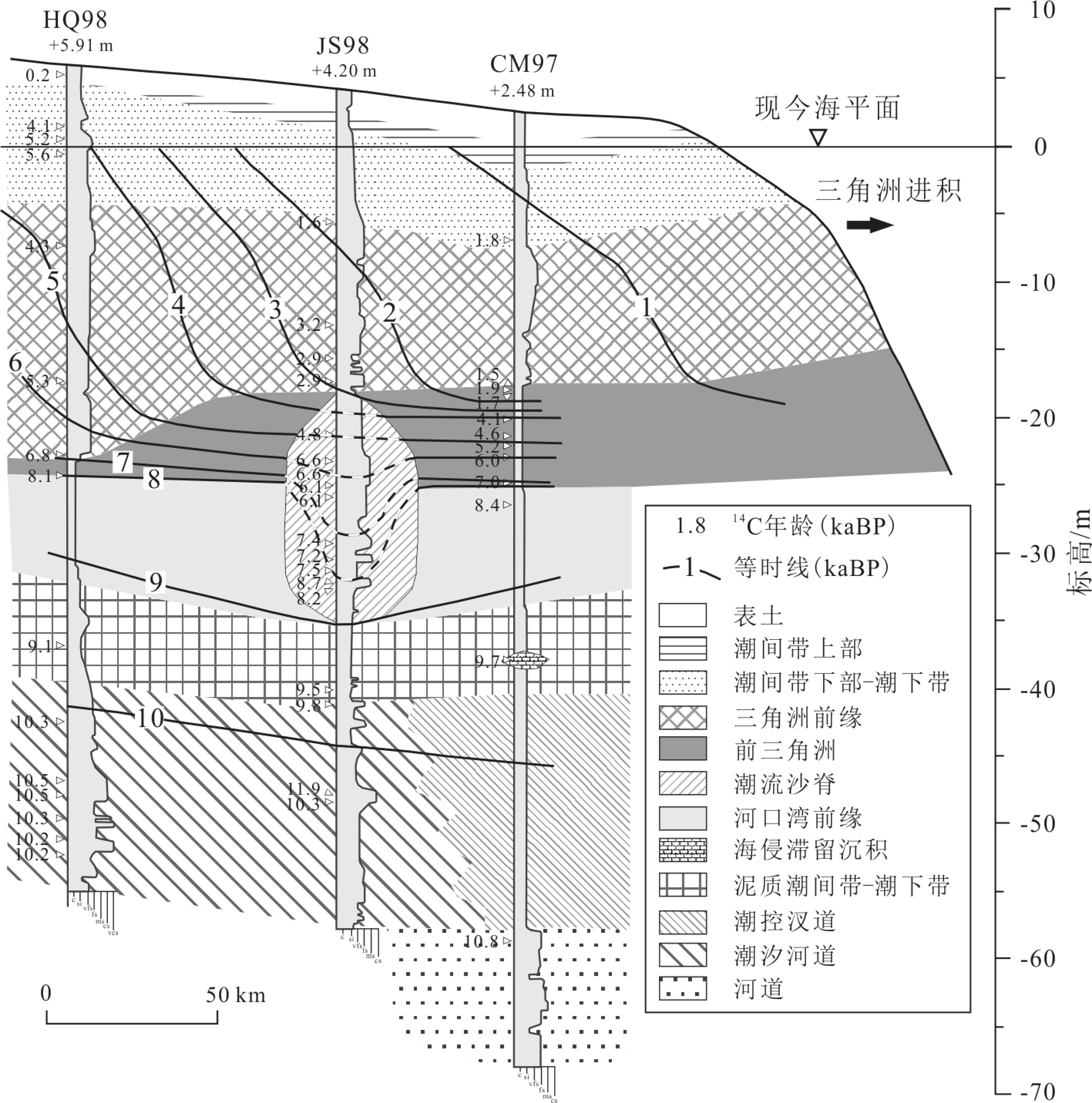
图 3 长江三角洲全新世层序地层结构[46]
a. 地层及等时线空间展布;b. 地层Wheeler图解。缩写:MFS,最大海泛面;TS,海侵面;HST,高水位体系域;TST,海侵体系域。
Figure 3. Holocene sequence stratigraphy across the Yangtze River mouth [46]
(a)Chronostratigraphic chart. Blue lines represent the chronostratigraphic boundaries. (b)Wheeler diagram. Abbreviation: MFS, Maximum flooding surface; TS, transgressive surface; HST, highstand systems tract; TST, transgressive systems tract.
![]()
![]()
![]()
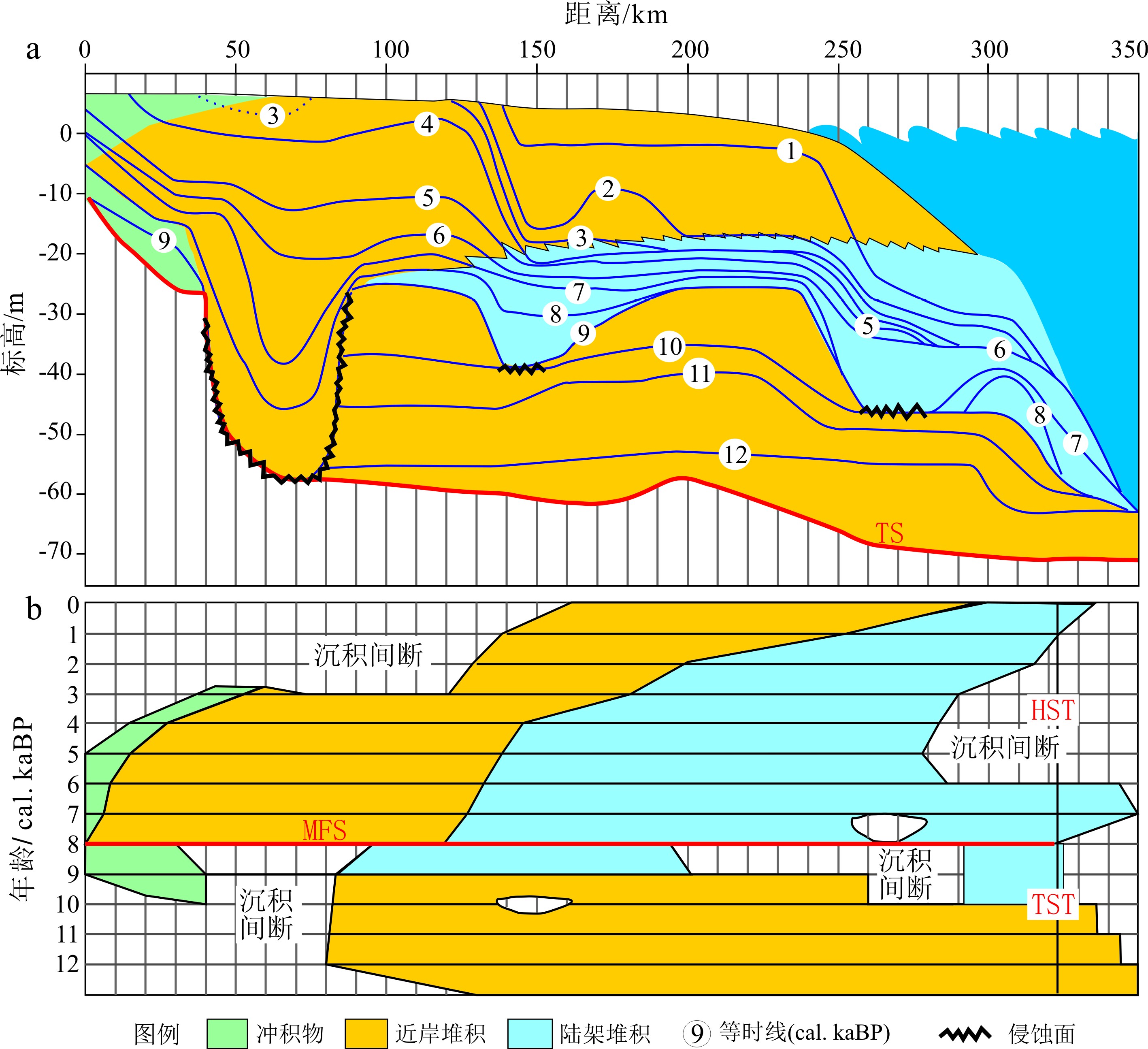
图 6 红河三角洲冰后期沉积物A-B和C-D纵剖面层序地层解释[10]
缩写:MxFS,最大海泛面;TS,海侵面;HST,高水位体系域;TST,海侵体系域;LST,低水位体系域;IFS,初始海泛面;SB,层序边界。
Figure 6. Sequence stratigraphy of the post-LGM sediments of the longitudinal sections A−B and C−D[10]
Abbreviation: MxFS, Maximum flooding surface; TS, transgressive surface; HST, highstand systems tract; TST, transgressive systems tract; LST, lowstand systems tract; IFS, initial flooding surface; SB, sequence boundary.
![]()
![]()
表 1 五大三角洲开始建造时间对比
Table 1 A comparison of delta initiation time in South and East Asian
 下载: 导出CSV
表 2 东、南亚五大河流建坝前水文泥沙特征
Table 2 Characteristics of Hydrology and sediment load before dam construction for Eeast and South Asia rivers
下载: 导出CSV
-
[1] Gilbert G. The topographic features of lake shores [J]. Nature, 1886, 34(873): 269-270. doi: 10.1038/034269a0
[2] Barrell J. Criteria for the recognition of ancient delta deposits [J]. GSA Bulletin, 1912, 23(1): 377-446. doi: 10.1130/GSAB-23-377
[3] Scruton P C. Delta building and the deltaic sequence[M]//Shepard F P, Phleger F B, Van Andel T H. Recent Sediments Northwest Gulf of Mexico. Tulsa: American Association of Petroleum Geologists Symposium Volume, 1960: 82-102.
[4] Coleman J M, Wright L D. Modern river delta: vari-ability of processes and sand bodies[M]//Broussard M L. Deltas: Models for Exploration. Houston, TX: Houston Geological Society, 1975: 99-149.
[5] Galloway W E. Process framework for describing the morphologic and stratigraphic evolution of deltaic depositional systems[M]//Broussard M L. Deltas: Models for Exploration. Houston, TX: Houston Geological Society, 1975: 87-98.
[6] Stanley D J, Warne A G. Worldwide initiation of Holocene marine deltas by deceleration of sea-level rise [J]. Science, 1994, 265(5169): 228-231. doi: 10.1126/science.265.5169.228
[7] Hori K, Tanabe S, Saito Y, et al. Delta initiation and Holocene sea-level change: example from the Song Hong (Red River) delta, Vietnam [J]. Sedimentary Geology, 2004, 164(3-4): 237-249. doi: 10.1016/j.sedgeo.2003.10.008
[8] Hori K, Saito Y, Zhao Q H, et al. Evolution of the coastal depositional systems of the Changjiang (Yangtze) River in response to late Pleistocene-Holocene sea-level changes [J]. Journal of Sedimentary Research, 2002, 72(6): 884-897. doi: 10.1306/052002720884
[9] Song B, Li Z, Saito Y, et al. Initiation of the Changjiang (Yangtze) delta and its response to the mid-Holocene sea level change [J]. Palaeogeography, Palaeoclimatology, Palaeoecology, 2013, 388: 81-97. doi: 10.1016/j.palaeo.2013.07.026
[10] Tanabe S, Saito Y, Vu Q L, et al. Holocene evolution of the Song Hong (Red River) delta system, northern Vietnam [J]. Sedimentary Geology, 2006, 187(1-2): 29-61. doi: 10.1016/j.sedgeo.2005.12.004
[11] Ta T K O, Nguyen V L, Tateishi M, et al. Holocene delta evolution and depositional models of the Mekong River Delta, southern Vietnam[M]//Giosan L, Bhattacharya J P. River Deltas—Concepts, Models, and Examples. Tulsa: SEPM Society for Sedimentary Geology, 2005: 453-466.
[12] Li Y X, Törnqvist T E, Nevitt J M, et al. Synchronizing a sea-level jump, final Lake Agassiz drainage, and abrupt cooling 8200 years ago [J]. Earth and Planetary Science Letters, 2012, 315-316: 41-50. doi: 10.1016/j.jpgl.2011.05.034
[13] Zong Y Q, Huang K Y, Yu F L, et al. The role of sea-level rise, monsoonal discharge and the Palaeo-landscape in the early Holocene evolution of the Pearl River delta, southern China [J]. Quaternary Science Reviews, 2012, 54: 77-88. doi: 10.1016/j.quascirev.2012.01.002
[14] Goodbred Jr S L, Kuehl S A. The significance of large sediment supply, active tectonism, and eustasy on margin sequence development: late Quaternary stratigraphy and evolution of the Ganges-Brahmaputra delta [J]. Sedimentary Geology, 2000, 133(3-4): 227-248. doi: 10.1016/S0037-0738(00)00041-5
[15] Bard E, Hamelin B, Arnold M, et al. Deglacial sea-level record from Tahiti corals and the timing of global meltwater discharge [J]. Nature, 1996, 382(6588): 241-244. doi: 10.1038/382241a0
[16] Hanebuth T, Stattegger K, Grootes P M. Rapid flooding of the sunda shelf: a late-glacial sea-level record [J]. Science, 2000, 288(5468): 1033-1035. doi: 10.1126/science.288.5468.1033
[17] Shackleton N J. The 100, 000-year ice-age cycle identified and found to lag temperature, carbon dioxide, and orbital eccentricity [J]. Science, 2000, 289(5486): 1897-1902. doi: 10.1126/science.289.5486.1897
[18] Yokoyama Y, Lambeck K, De Deckker P, et al. Timing of the Last Glacial Maximum from observed sea-level minima [J]. Nature, 2000, 406(6797): 713-716. doi: 10.1038/35021035
[19] Siddall M, Rohling E J, Almogi-Labin A, et al. Sea-level fluctuations during the last glacial cycle [J]. Nature, 2003, 423(6942): 853-858. doi: 10.1038/nature01690
[20] Bassett S E, Milne G A, Mitrovica J X, et al. Ice sheet and solid earth influences on far-field sea-level histories [J]. Science, 2005, 309(5736): 925-928. doi: 10.1126/science.1111575
[21] Peltier W R, Fairbanks R G. Global glacial ice volume and Last Glacial Maximum duration from an extended Barbados sea level record [J]. Quaternary Science Reviews, 2006, 25(23-24): 3322-3337. doi: 10.1016/j.quascirev.2006.04.010
[22] Bard E, Hamelin B, Fairbanks R G. U-Th ages obtained by mass spectrometry in corals from Barbados: sea level during the past 130, 00 years [J]. Nature, 1990, 346(6283): 456-458. doi: 10.1038/346456a0
[23] Hori K, Saito Y. An early Holocene sea-level jump and delta initiation [J]. Geophysical Research Letters, 2007, 34(18): L18401. doi: 10.1029/2007GL031029
[24] Reed D J. Sea-level rise and coastal marsh sustainability: geological and ecological factors in the Mississippi delta plain [J]. Geomorphology, 2002, 48(1-3): 233-243. doi: 10.1016/S0169-555X(02)00183-6
[25] 李高聪, 高抒, 高建华. 全新世以来亚洲七个主要河口三角洲的生长极限[J]. 海洋地质与第四纪地质, 2018, 38(1):11-22. [LI Gaocong, GAO Shu, GAO Jianhua. Modeling the growth limit of seven major Holocene river deltas in Asia [J]. Marine Geology & Quaternary Geology, 2018, 38(1): 11-22. [26] Coleman J M. Brahmaputra River: channel processes and sedimentation [J]. Sedimentary Geology, 1969, 3(2-3): 129-239. doi: 10.1016/0037-0738(69)90010-4
[27] Wang Y J, Cheng H, Edwards R L, et al. A high-resolution absolute-dated Late Pleistocene monsoon record from Hulu Cave, China [J]. Science, 2001, 249(5550): 2345-2348.
[28] Fleitmann D, Burns S J, Mudelsee M, et al. Holocene forcing of the Indian monsoon recorded in a stalagmite from southern Oman [J]. Science, 2003, 300(5626): 1737-1739. doi: 10.1126/science.1083130
[29] Yuan D X, Cheng H, Edwards R L, et al. Timing, duration, and transitions of the last interglacial Asian monsoon [J]. Science, 2004, 304(5670): 575-578. doi: 10.1126/science.1091220
[30] Li C X, Chen Q Q, Zhang J Q, et al. Stratigraphy and paleoenvironmental changes in the Yangtze delta during the Late Quaternary [J]. Journal of Asian Earth Sciences, 2000, 18(4): 453-469. doi: 10.1016/S1367-9120(99)00078-4
[31] Li C X, Wang P, Sun H P, et al. Late Quaternary incised-valley fill of the Yangtze delta (China): its stratigraphic framework and evolution [J]. Sedimentary Geology, 2002, 152(1-2): 133-158. doi: 10.1016/S0037-0738(02)00066-0
[32] Hori K, Saito Y, Zhao Q H, et al. Sedimentary facies of the tide-dominated paleo-Changjiang (Yangtze) estuary during the last transgression [J]. Marine Geology, 2001, 177(3-4): 331-351. doi: 10.1016/S0025-3227(01)00165-7
[33] Wang Z H, Zhuang C C, Saito Y, et al. Early mid-Holocene sea-level change and coastal environmental response on the southern Yangtze delta plain, China: implications for the rise of Neolithic culture [J]. Quaternary Science Reviews, 2012, 35: 51-62. doi: 10.1016/j.quascirev.2012.01.005
[34] Wang Z H, Zhan Q, Long H Y, et al. Early to mid-Holocene rapid sea-level rise and coastal response on the southern Yangtze delta plain, China [J]. Journal of Quaternary Science, 2013, 28(7): 659-672. doi: 10.1002/jqs.2662
[35] Zong Y, Huang G, Switzer A D, et al. An evolutionary model for the Holocene formation of the Pearl River delta, China [J]. The Holocene, 2009, 19(1): 129-142. doi: 10.1177/0959683608098957
[36] Tanabe S, Hori K, Saito Y, et al. Sedimentary facies and radiocarbon dates of the Nam Dinh-1 core from the Song Hong (Red River) delta, Vietnam [J]. Journal of Asian Earth Sciences, 2003, 21(5): 503-513. doi: 10.1016/S1367-9120(02)00082-2
[37] Nguyen V L, Ta T K O, Saito Y. Early Holocene initiation of the Mekong River delta, Vietnam, and the response to Holocene sea-level changes detected from DT1 core analyses [J]. Sedimentary Geology, 2010, 230(3-4): 146-155. doi: 10.1016/j.sedgeo.2010.07.006
[38] Tamura T, Saito Y, Sieng S, et al. Initiation of the Mekong River delta at 8 ka: evidence from the sedimentary succession in the Cambodian lowland [J]. Quaternary Science Reviews, 2009, 28(3-4): 327-344. doi: 10.1016/j.quascirev.2008.10.010
[39] Tjallingii R, Stattegger K, Wetzel A, et al. Infilling and flooding of the Mekong River incised valley during deglacial sea-level rise [J]. Quaternary Science Reviews, 2010, 29(11-12): 1432-1444. doi: 10.1016/j.quascirev.2010.02.022
[40] 李国刚, 胡邦琦, 毕建强, 等. 黄河三角洲ZK1孔晚第四纪以来沉积层序演化及其古环境意义[J]. 沉积学报, 2013, 31(6):1050-1058. [LI Guogang, HU Bangqi, BI Jianqiang, et al. Stratigraphic evolution of the Huanghe Delta (Bohai Sea) since the Late Quaternary and its Paleoenvironmental implications: evidence from core ZK1 [J]. Acta Sedimentologica Sinica, 2013, 31(6): 1050-1058. [41] 成国栋, 薛春汀. 黄河三角洲沉积地质学[M]. 北京: 地质出版社, 1997. CHENG Guodong, XUE Chunting. Sedimentary Geology of the Yellow River Delta[M]. Beijing: Geology Press, 1997.
[42] 庄振业, 许卫东, 刘东生, 等. 渤海南部S3孔晚第四纪海相地层的划分及环境演变[J]. 海洋地质与第四纪地质, 1999, 19(2):27-35. [ZHUANG Zhenye, XU Weidong, LIU Dongsheng, et al. Division and environmental evolution of Late Quaternary marine beds of S3 hole in the Bohai Sea [J]. Marine Geology & Quaternary Geology, 1999, 19(2): 27-35. [43] 阎玉忠, 王宏, 李凤林, 等. 渤海湾西岸BQ1孔揭示的沉积环境与海面波动[J]. 地质通报, 2006, 25(3):357-382. [YAN Yuzhong, WANG Hong, LI Fenglin, et al. Sedimentary environment and sea-level fluctuations revealed by borehole BQ1 on the west coast of the Bohai Bay, China [J]. Geological Bulletin of China, 2006, 25(3): 357-382. doi: 10.3969/j.issn.1671-2552.2006.03.006 [44] Liu J, Saito Y, Wang H, et al. Stratigraphic development during the Late Pleistocene and Holocene offshore of the Yellow River delta, Bohai Sea [J]. Journal of Asian Earth Sciences, 2009, 36(4-5): 318-331. doi: 10.1016/j.jseaes.2009.06.007
[45] 庞家珍, 司书亨. 黄河河口演变 I. 近代历史变迁[J]. 海洋与湖沼, 1979, 10(2):136-141. [PANG Jiazhen, SI Shuheng. The estuary changes of Huanghe River I. Changes in modern time [J]. Oceanologia et Limnologia Sinica, 1979, 10(2): 136-141. [46] Wang Z H, Saito Y, Zhan Q, et al. Three-dimensional evolution of the Yangtze River mouth, China during the Holocene: impacts of sea level, climate and human activity [J]. Earth-Science Reviews, 2018, 185: 938-955. doi: 10.1016/j.earscirev.2018.08.012
[47] Tamura T, Saito Y, Nguyen V L, et al. Origin and evolution of inter distributary delta plains; insights from Mekong River delta [J]. Geology, 2012, 40(4): 303-306. doi: 10.1130/G32717.1
[48] Walker M J C, Berkelhammer M, Björck S, et al. Formal subdivision of the Holocene series/epoch: a discussion paper by a working group of intimate (integration of ice-core, marine and terrestrial records) and the subcommission on quaternary stratigraphy (international commission on stratigraphy) [J]. Journal of Quaternary Science, 2012, 27(7): 649-659. doi: 10.1002/jqs.2565
[49] Bridge J S. Fluvial facies models: recent developments[M]//Posamentier H W, Walker R. Facies Models Revisited. Tulsa: SEPM, 2006: 85-170.
[50] 王张华, Liu J P, 赵宝成. 全新世长江泥沙堆积的时空分布及通量估算[J]. 古地理学报, 2007, 9(4):419-429. [WANG Zhanghua, Liu J P, ZHAO Baocheng. Spatial and temporal distribution of Changjiang sediments and estimation of sediment budget during the Holocene [J]. Journal of Palaeogeography, 2007, 9(4): 419-429. doi: 10.3969/j.issn.1671-1505.2007.04.008 [51] 陈吉余, 沈焕庭, 恽才兴, 等. 长江河口动力过程和地貌演变[M]. 上海: 上海科学技术出版社, 1988: 205. CHEN Jiyu, SHEN Huanting, YUN Caixing, et al. Process of Dynamics and Geomorphology of the Changjiang Estuary[M]. Shanghai: Shanghai Scientific and Technical Publishers, 1988: 205.
-
期刊类型引用(1)
1. 康勇,郑希龙,魏建和,李榕涛,李伟杰,邓开丽,符丽,杨海建,杨新全. 西沙群岛植物资源物种组成及药用植物多样性研究. 中国现代中药. 2023(03): 462-470 .  百度学术
百度学术
其他类型引用(1)


计量
- 文章访问数: 4541
- HTML全文浏览量: 1086
- PDF下载量: 198
- 被引次数: 2
