Holocene extreme flood events in the Yangtze River Basin: Research progress and implications
-
摘要:
随着全球气候变暖和人类活动加剧,全球洪水事件的发生频率与强度正在快速变化,揭示洪水发生规律及其驱动机制是当前古洪水水文学和全球变化研究的热点问题。长江流域作为中国洪涝灾害最为严重的区域之一,其洪水活动近年来呈现快速异常变化,较短的现代器测记录已不能满足未来洪水灾害风险预测的需求,迫切需要通过各种长时间尺度记录揭示过去时期长江流域洪水事件与气候变化之间的关系。本文通过综述各种极端洪水事件的地质记录和历史记录,确定全新世以来极端洪水事件的频发期,并与区域关键气候代用指标进行对比,发现洪水事件频发期主要跟气候的急剧突变和强烈的人类活动有关。然而准确预测长江流域洪水事件未来演化趋势,需不断加强各种代用记录的综合研究,进一步探索洪水发生机制与气候变化和人类活动耦合关系,并加强有关数值模拟方面的研究,以便于为未来长江流域的洪涝灾害防御、城乡规划优化布局、资源合理开发利用提供科学依据和决策支持。
Abstract:With global warming and the intensification of human activities, the frequency and magnitude of large river flood events are increasing in recent years. To reveal the regularity of flood occurrence and its driving mechanism is a hot issue in the study of paleoflood hydrology and global change. As one of the regions with the most severe flood disasters in China, the Yangtze River Basin has shown rapid and abnormal changes in flood activities in recent years. Short modern measurement records can no longer meet the needs of future flood disaster risk prediction, and it is urgent to reveal the relationship between flood events and climate change in the Yangtze River Basin in the past through various long-term records. By summarizing the geological and historical records of various extreme flood events, the frequent periods of extreme flood events since the Holocene were determined and compared with key regional climate proxies. However, to accurately predict the future evolution trend of flood events in the Yangtze River Basin, it is necessary to strengthen continuously the comprehensive research of various proxy records, to further explore the coupling relationship of flood occurrence mechanisms to climate changes and human activities, and to strengthen research on numerical simulation. This study provided a scientific basis and decision support for future flood disaster prevention, urban and rural planning optimization layout, and rational resource development and utilization in the Yangtze River Basin.
-
Keywords:
- paleoflood events /
- sedimentary record /
- global warming /
- human activities /
- the Yangtze River
-
平北地区面积近1 800 km2(图1),自1988年钻探宝云亭1井以来,经过30年的勘探开发,已建成投产3个油气田,主要勘探目的层为中上始新统平湖组。勘探初期由于缺少三维地震资料,多利用二维地震测线开展工作,主要以勘探构造油气藏为主,预探井多布署在构造高点。随着三维地震资料覆盖率的增加,勘探及开发工作的不断深入,发现部分已钻的构造圈闭不落实,圈闭无效,钻遇的气藏为构造―岩性复合气藏;同时3个气田的多口开发井也证实,砂体在平面上连续性差,气藏多受构造和岩性双重因素控制,因此,平北地区构造―岩性复合圈闭具有较大的勘探潜力。平北地区剩余构造圈闭数量少,条件差,资源规模小,可钻探性低,截止目前,平北地区探井密度约为0.017口/km2,勘探程度低,勘探潜力大,因此,构造―岩性复合圈闭、岩性圈闭应为下一步的主要勘探方向。
对于断陷期构造―岩性复合圈闭的勘探而言,砂体的展布范围不仅控制了圈闭规模的大小,更从根本上决定了圈闭是否存在,因此,弄清砂体的展布形态至关重要。前人研究表明,砂体的分布及富集受多重地质因素的控制。贾承造等认为盆地的构造运动、古气候变迁、古物源等因素控制了砂体形成和分布[1];李丕龙等认为陆相断陷盆地不同断裂形成的断阶、段坡或断裂坡折带等对砂体发育与分布起着重要的控制作用[2];邹才能等提出陆相断陷盆地内砂体分布主要受控于斜坡、断裂和水深3个重要因素[3];冯有良提出层序界面控制了地层油气藏的发育,盆缘的沟谷和构造坡折带控制的层序低位体系域和高位体系域砂体是岩性油气藏的主要储集体[4]。赵贤正等以二连盆地为例,认为砂体的展布主要受到构造带类型、同沉积断层组合样式、体系域类型、坡折带类型及沉积相类型的控制[5-6]。
通过对西湖凹陷保俶斜坡带平北地区砂体的形成和分布的研究认为该区为缓坡背景,砂体分布主要受到构造古地貌、坡折带类型、层序样式及沉积微相类型的控制。
1. 构造古地貌及可容纳空间控制地层厚度及沉积体规模
西湖凹陷自西向东可以划分为保俶斜坡带、三潭深凹带、中央背斜带、白堤深凹带及天屏断阶带5个次级构造单元。平北地区位于保俶斜坡带中段,总体上呈西南高、北东低的斜坡。主力勘探目的层中上始新统平湖组为一个从水进到水退的过程[7],从下至上可划分为平下段、平中段及平上段3个段,平下段可进一步划分为平下下、平下上2个亚段。
平湖组早期继承了基底先存古地貌,自南向北发育宝云亭、武云亭、孔雀亭3个古鼻隆,具有隆洼相间的地貌格局,西部海礁凸起长期遭受剥蚀,为主要物源区,沉积物通过古地貌沟谷、断槽物源通道大量卸载于具有较大可容纳空间的古地貌低洼区,造成古隆起上下地层厚度差别大,在古地貌低洼区可达800 m以上,斜坡大部分地区为200~300 m(图2)。同时,受古地貌限制,沉积体及砂体展布范围较局限。
![图 2 平湖组不同时期古地貌图、地层厚度图、沉积体展布范围对比图]() 图 2 平湖组不同时期古地貌图、地层厚度图、沉积体展布范围对比图Figure 2. Diagram of paleogeomorphy, strata thickness and depositional areas in different stages of Pinghu Formation
图 2 平湖组不同时期古地貌图、地层厚度图、沉积体展布范围对比图Figure 2. Diagram of paleogeomorphy, strata thickness and depositional areas in different stages of Pinghu Formation平下上段,构造活动及古地貌分隔性有所减弱,但该时期古地貌依然是沉积体发育的主要控制因素,地层厚度为0~600 m,沉积物仍主要卸载于古地貌低势区(图2)。同时,该期为平湖组最大海泛期,A/S比较高,整体上沉积体及砂体规模较小,但也不乏局部古地貌低洼处较厚砂体富集。例如C5井,在平下段单层厚度>30 m,累计储层厚度>70 m的砂层。
平中段进入断拗转换阶段,构造活动大幅减弱,随着海进到海退的转换,整个斜坡以填平补齐作用为主,地层展布范围大,厚度更加均衡,沉积体规模增大(图2),以向海方向进积的三角洲为主,砂体分布范围更大,连续性更好。
平上段平北地区形成一个宽缓的斜坡,构造古地貌对沉积体控制作用基本消失,沉积类型以规模较平中段更大的三角洲为主,地层厚度为0~300 m,厚度差进一步减小(图2),砂体更加发育,连续性增强。
2. 同沉积断裂坡折带控制砂体的展布
长期活动的同沉积断裂形成的“构造坡折带”制约着盆地充填可容纳空间的变化,控制着低水位体系域、高水位体系域三角洲―岸线体系的发育部位,对沉积体系的发育和砂体分布起重要的控制作用[8-10]。平湖组沉积于中―晚始新世断陷―断拗转换期,断裂活动对砂体的发育展布具有较强的控制作用,尤其是断层活动较强的平下下段及平下上段。
平北地区发育二级―五级断裂,其中三级及以上断裂组成的断裂坡折带对沉积及砂体具有明显的控制作用。在始新世持续性北西―南东方向扭张力作用下形成一系列NE―SW走向的断裂体系(图3)。同时,受控于先存古地貌,平北地区自南向北发育4种断裂系统组合样式。
![图 3 平北地区断裂体系、组合方式及控砂模式图]() 图 3 平北地区断裂体系、组合方式及控砂模式图Figure 3. Map of fractures system and their distribution patterns and their control over sandbodies in Pingbei region
图 3 平北地区断裂体系、组合方式及控砂模式图Figure 3. Map of fractures system and their distribution patterns and their control over sandbodies in Pingbei region2.1 帚状断阶断裂坡折带及砂体分布样式
帚状断裂坡折带见于A区,以发育一条控凹的二级边界主断裂为特征,垂向断距最大可达4 000 m,主断裂北部末端呈帚状撒开,分枝成若干条三级―四级次级伴生断裂,其中三级断裂的平面延伸长度约10 km,垂向断距约1 000 m,对沉积及砂体的展布具有较强的控制作用。四级断裂垂向断距约500 m,对砂体的控制作用较小。这种断裂的形成一般与凹陷走滑作用有关。帚状断裂坡折带对沉积体及砂体的控制作用主要表现为主干断裂捕获其上升盘水系,控制碎屑体系向凹陷内的推进方向,主干断裂的延伸方向及发散部位控制着沉积中心及砂体分布。在主干断裂主体部位下降盘或内叉角的构造低部位砂体厚度较大,形成“断角砂体”。该区位于主干断裂下降盘的A3井平下段均发育厚层砂体。而帚状末端四级断裂控制的A5井砂体则欠发育(图3)。
2.2 垒堑组合断裂坡折带及砂体分布样式
垒堑组合型断裂坡折带发育于B区、C区。这种断裂坡折带的主要特征为发育2组相对倾向的断裂,平面上与斜坡倾向相同的顺向断裂(B区)呈平行式展布,多为三级断裂,与斜坡倾向相反的反向断裂(C区)多为反“y”字型组合,垂向上形成多个反向翘倾的半地堑构造。这种断裂坡折带组合的发育与宝云亭古隆鼻的有关。垒堑相间型断裂坡折带对沉积及砂体的控制作用主要体现在反向大断裂捕获其上游的沉积体,使沉积物沿限定型地堑的大断裂根部向前推进,垂直于断裂,沿翘倾方向砂体逐渐减薄尖灭。每个三级反向断裂控制一个半地堑,形成一个沉积中心(图3)。C5井靠近反向断裂根部,平下段发育多层厚层砂体,向翘倾方向C4井砂体逐渐减薄,而位于翘倾端的C3井砂体已尖灭,发育泥岩。而地垒上砂体整体发育欠佳,较厚层的砂体主要发育于古隆起上的次级低洼区。
2.3 顺向翘倾断块断裂坡折带及砂体分布样式
顺向翘倾断块型断裂坡折带主要发育于D区,以伸展构造样式为主。平面上2~3条NE―SW走向的三级弧形断裂形成一个控沉积坡折带,由斜坡高部位到低部位发育4个断裂坡折带,垂向上由坡折带形成逐级下掉的顺向翘倾断块。顺向翘倾断块断裂坡折带对沉积的控制作用一方面体现在两条断层相交处容易形成沉积物输送通道,另一方面,沉积体垂直于断层走向上沿断阶逐级沉积,由于翘倾作用,断层根部具有相对较大的可容空间,形成较厚砂体堆积(图3)。D区的8口钻井均钻探在靠近断层根部处,均在平下段钻遇较厚砂体。
3. 体系域类型控制砂体的时空配置
据经典层序地层学原理,可将一套完整的层序运用三分法划分出低位体系域、海侵体系域和高位体系域。体系域的形成与可容空间变化有着十分密切的联系,随着可容空间的变化,不同类型体系域控制了各沉积体系砂体的形成与分布[11-15]。西湖凹陷始新统平湖组为一个完整的二级层序。在二级层序格架内划分了低位体系域平下下段,海侵体系域平下上段及高位体系域平中―上段。
3.1 低位体系域(LST)
低位体系域(LST)期,基准面上升缓慢,沉积物供给速率大于可容空间增加速率,通常情况下以发育富砂质的扇三角洲、辫状河三角洲沉积。平北地区低位体系域发育时期受到强烈的断陷作用及古地貌格局的限制,发育近物源,限定型的潮控三角洲沉积(图2)。钻井揭示平下下段的厚层砂岩发育,多为中粗砂岩,常含砾,测井曲线多呈箱型,具有正旋回。砂地比为30%~50%(图5),研究认为:当地层砂地比>60%,发育构造圈闭,砂地比<30%发育岩性圈闭,介于两者中间的多发育构造―岩性复合圈闭[6]。因此,就沉积序列而言,平下段适合构造―岩性复合圈闭的发育,同时,其上覆的平下上段大规模海侵泥岩也具备形成区域性盖层的条件,具备很好的储盖组合匹配条件(图4,图5)。而目前,平北地区平下下多口钻井均揭示构造―岩性复合圈闭,直接证明平下下段具备发育复合圈闭的地质条件。
![图 5 平北地区典型钻井层序对比图]() 图 5 平北地区典型钻井层序对比图Figure 5. Sequence stratigraphic profile of typical wells in Pingbei region
图 5 平北地区典型钻井层序对比图Figure 5. Sequence stratigraphic profile of typical wells in Pingbei region![图 4 平北地区层序模式图(以垒堑型为例)]() 图 4 平北地区层序模式图(以垒堑型为例)Figure 4. Sequence stratigraphy of the Pingbei region(Take the horst-graben pattern for example)
图 4 平北地区层序模式图(以垒堑型为例)Figure 4. Sequence stratigraphy of the Pingbei region(Take the horst-graben pattern for example)3.2 海侵体系域(TST)
海侵体系域(TST),基准面快速上升,沉积物供给速率远小于新增可容空间速率,通常易形成退积型近岸水下扇砂体。平北地区海侵体系域发育时期,断陷作用逐渐趋弱,但海平面快速的上升仍然使可容空间增加速率远大于沉积物供给速率。沉积体快速向陆方向退积,虽然仍发育受古地貌限定型的辫状河三角洲沉积,但沉积体规模缩小。钻井揭示平下上段地层具有“泥包砂”的特征,大多数钻井泥地比在70%以上,是一套泥岩厚度大,横向分布稳定,具有一定可对比性的区域性盖层(图4)。只在局部断层“聚砂”作用强烈处见具有一定厚度的砂岩发育。这种沉积建造对于岩性圈闭的发育提供很好的条件,孤立的砂岩被泥岩包裹,具有很好的生排烃条件及封堵条件。同时由于泥岩生烃等作用容易在砂岩中形成高压,对储层物性起到较好的保护作用。C区的C5井在平下上段钻遇的这类气藏物性好,产量高(图4)。
3.3 高位体系域(HST)
在高水位时期,受气候、构造及外部水系等因素影响基准面呈高频率的变化,沉积物供给速率等于或大于新增可容空间速率,通常发育加积型或进积型扇三角洲砂体。平中―上段西湖凹陷进入断拗转换阶段,构造趋于稳定,平北地区发育填平补齐的沉积作用,发育规模较大的受潮汐影响三角洲沉积。钻井揭示平上段砂体层数多,厚度大,砂地比最高可达80%,砂体横向连续性变好(图5)。在较高的砂地比条件下,不利于岩性圈闭的形成,侧向需要依靠断层形成封堵。同时,平湖组高位体系域上覆为渐新统花港组低位域富砂沉积,缺乏区域性泥岩盖层,不利于油气藏的保存,对于岩性圈闭的勘探应主要关注三角洲前缘砂地比降低至60%以下的地区。
4. 沉积相带控制砂体的储层物性
盆地的构造、沉积背景决定其沉积体系的形成和展布,不同类型沉积相对砂体的储集特征具有重要的控制作用,不同类型砂体的沉积构造、沉积韵律、厚度、岩性储集特征都存在着差异[16]。西湖凹陷平湖组具有局限海湾的沉积背景,发育辫状河三角洲―潮坪共生沉积体系。
平下下及平下上段,断陷作用形成较大的可容空间,在河流及轴向潮流的作用下发育潮控三角洲及河口湾沉积,河口湾前端发育放射状湾口型砂脊(图6)。砂体类型有三角洲前缘分流河道砂、潮道砂、潮坪砂、河口湾砂坝砂及潮汐砂脊砂。在潮汐能量较强的水动力环境下,三角洲前缘水下分流河道与潮道常具有相似的岩电特征,难以区分,统称为水道。目前,平北地区钻井已证实具有良好储集性能的砂体类型有:水道砂及河口湾砂坝砂。水道砂单层厚度一般为20~70 m,岩性以浅灰色中―粗砂岩为主,底部多含砾,测井曲线多呈微齿化箱型或钟型,岩心多见强水动力作用形成的板状交错层理、底砾及侵蚀面等(表1)。在埋深4 000 m以下仍保留部分原生孔隙,平均孔隙度为12.5%,平均渗透率可达5 mD。是平北地区深层优质的储层。河口湾砂坝主要发育在平北北部地区,钻井上单层厚度为10~30 m,以浅灰色细―粗砂岩为主(表1),偶含砾,测井曲线呈微齿化箱型或钟型,岩心上以较强水流形成的板状和平行层理为主。这类砂体由于受到潮汐水流的反复淘洗,成熟度高,抗压实能力强,在埋深大于4 100 m时仍保留部分原生孔隙,并常见溶孔和铸模孔。孔隙度为10%~20%,渗透率约为0.49~145 mD,平面上具有较强的非均质性。
表 1 平北地区不同类型砂体特征Table 1. The characteristics of different sandbodies in Pingbei region砂体类型 平下段 平中-上段 水道 河口湾砂坝 水下分流河道 单砂厚 20~70m 10~30m 10~40m 颜色 浅灰、灰白 浅灰、灰白 浅灰、灰白 岩性 砂岩 砂岩 砂岩 粒度 中-粗砂,含砾 细-粗砂,偶含砾 细砂-砾岩 岩电特征 


沉积构造 


孔隙度(%) 9.9~15(12.5) 9~19.56(13.77) 8~22.23(13.12) 渗透率(mD) 0.5~31.6(5.1) 0.49~145(21.88) 1~227(35.98) 平中―上段斜坡区构造稳定,断层活动微弱或停止活动,填平补齐及持续性海退,海湾内主要以平行岸线的潮流作用为主,沉积体以规模逐渐增大的受潮汐影响的非对称三角洲为主,三角洲逐渐向凹陷中央推进,三角洲前端发育受潮汐改造形成的与岸线斜交的潮汐砂脊(图7)。储集条件较好的砂体类型主要有三角洲前缘水下分流河道砂、潮汐砂脊砂。钻井揭示的三角洲前缘水下分流河道砂岩厚度多为30 m,岩性以浅灰色细砂岩―砾岩为主,测井曲线呈微齿化箱型,岩心上可见圆―次圆状的砾石定向排列及板状交错层理等反应牵引流沉积构造(表1)。水下分流河道砂岩在4 200 m埋深下仍保持部分原生孔隙,孔隙度多在10%以上,渗透率多大于1 mD,为平中上段有利储层。同时,砂脊砂目前虽未有钻井揭示,但从成因上,潮汐砂脊是三角洲前缘砂体经过潮汐等较强水流改造形成的,砂岩通常具有厚度大,成熟度高,抗压实能力强的特征,推测应具有较好的储层物性。并且潮汐砂脊常成群成带分布,易形成叠合连片的规模储量,是优质的勘探目标。
5. 结论
(1)平北地区砂体的发育及展布受古地貌及可容纳空间、同沉积断裂破折带、体系域类型以及沉积相类型多重因素控制。
(2)古地貌及可容纳空间从宏观上控制了地层厚度及沉积体规模,在此基础上由同沉积断裂坡折带及体系域类型具体控制了砂体的展布和时空配置关系,而沉积相类型控制了砂体的储集物性。
(3)平北地区平湖组平下下及平下上段是构造―岩性圈闭发育的主要层段,勘探方向为低位体系域控沉积断层下降盘的地势低洼汇砂区,而平中上段砂岩相对更发育,有利的岩性圈闭勘探区为三角洲前缘砂地比低或三角洲前端发育的潮汐砂脊带。
-
![]()
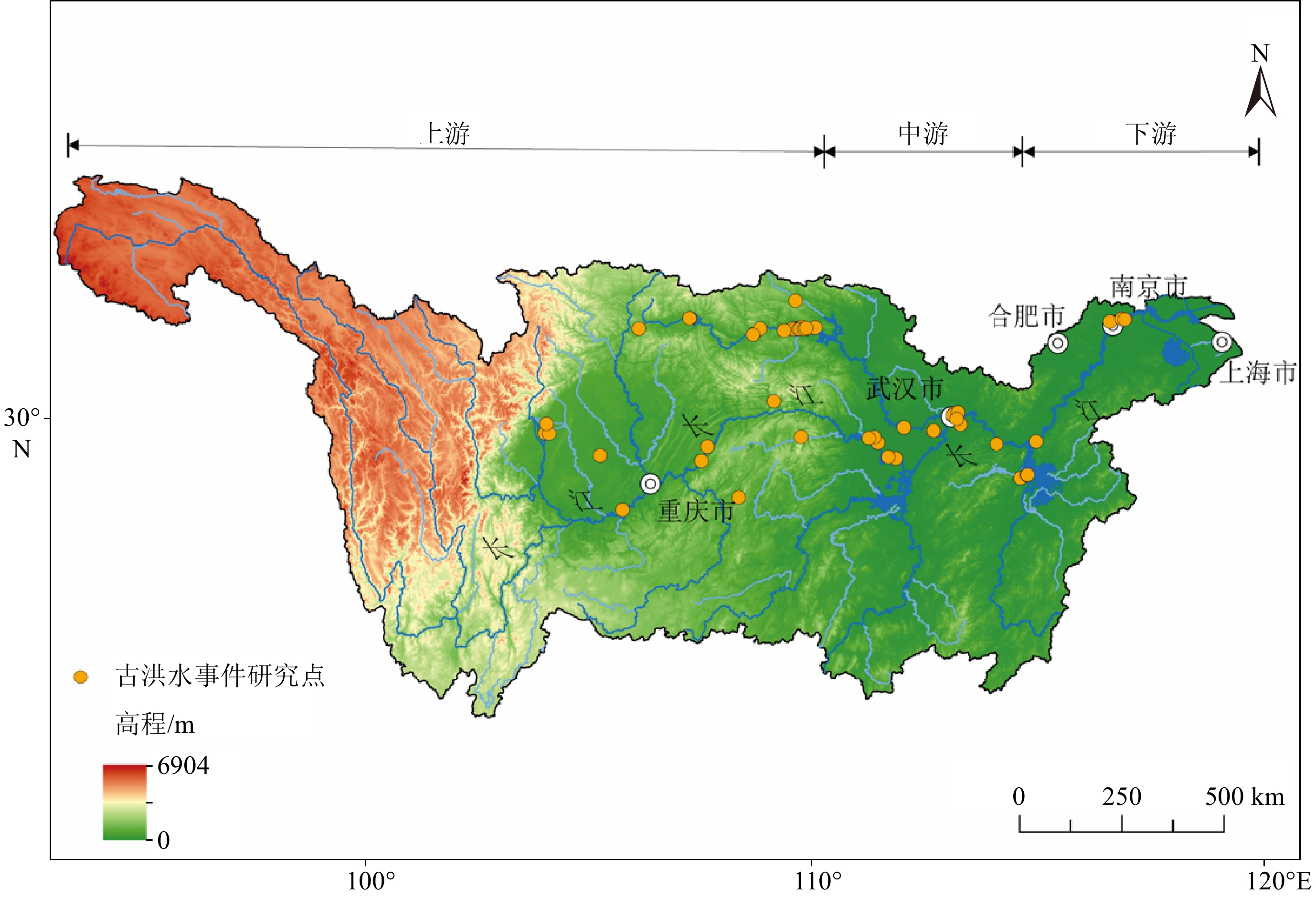
图 1 长江流域极端洪水记录研究点分布
Figure 1. Study sites of extreme events in the Yangtze River Basin
![]()
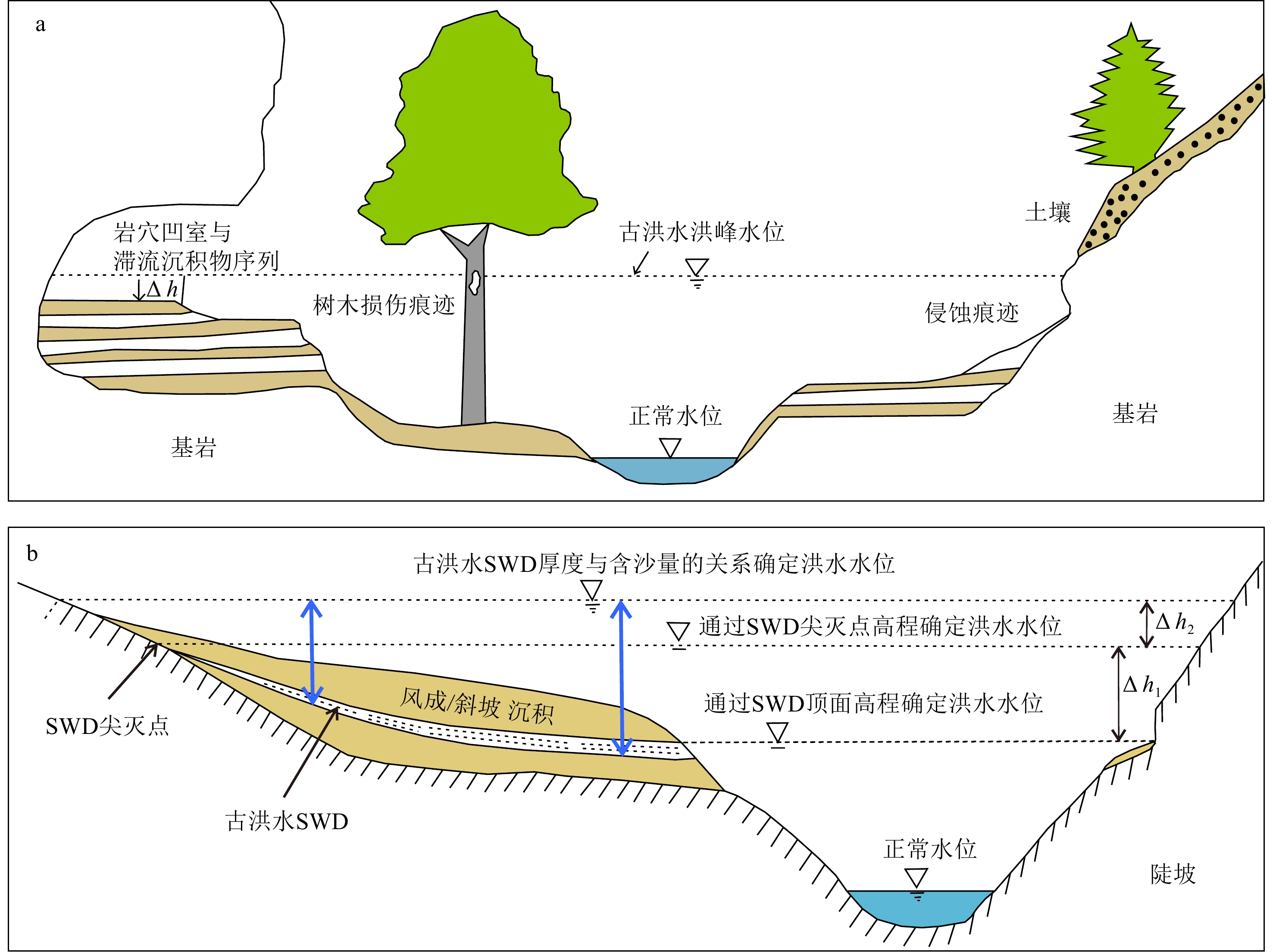
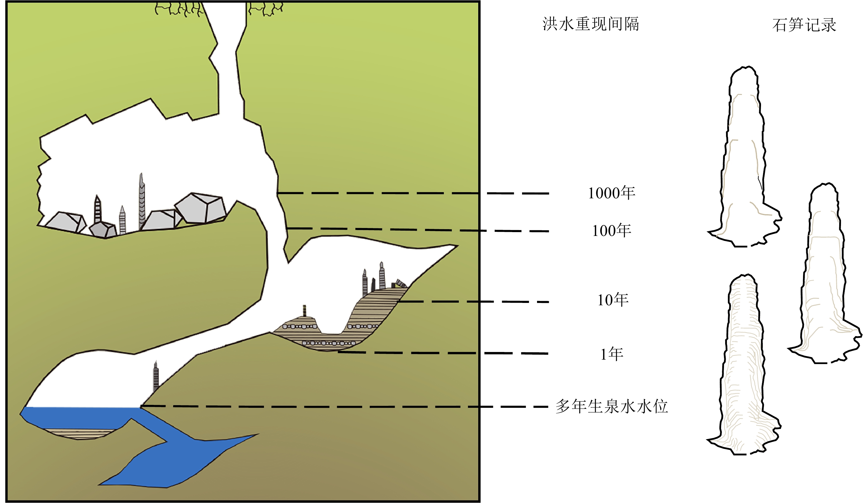
图 2 古洪水滞流沉积物野外位置及重建洪水方法
a:古洪水滞流沉积物示意图[65],b: 三种确定洪水水位方法示意图[66](据文献[65-66]修改)。
Figure 2. Field location of paleoflood sediment and flood reconstruction method
a: The schematic diagram of paleoflood SWD[65],b: Schematic diagram of three methods for determining flood level[66] (Modified according to references [65-66]).
![]()
![]()
![]()
![]()
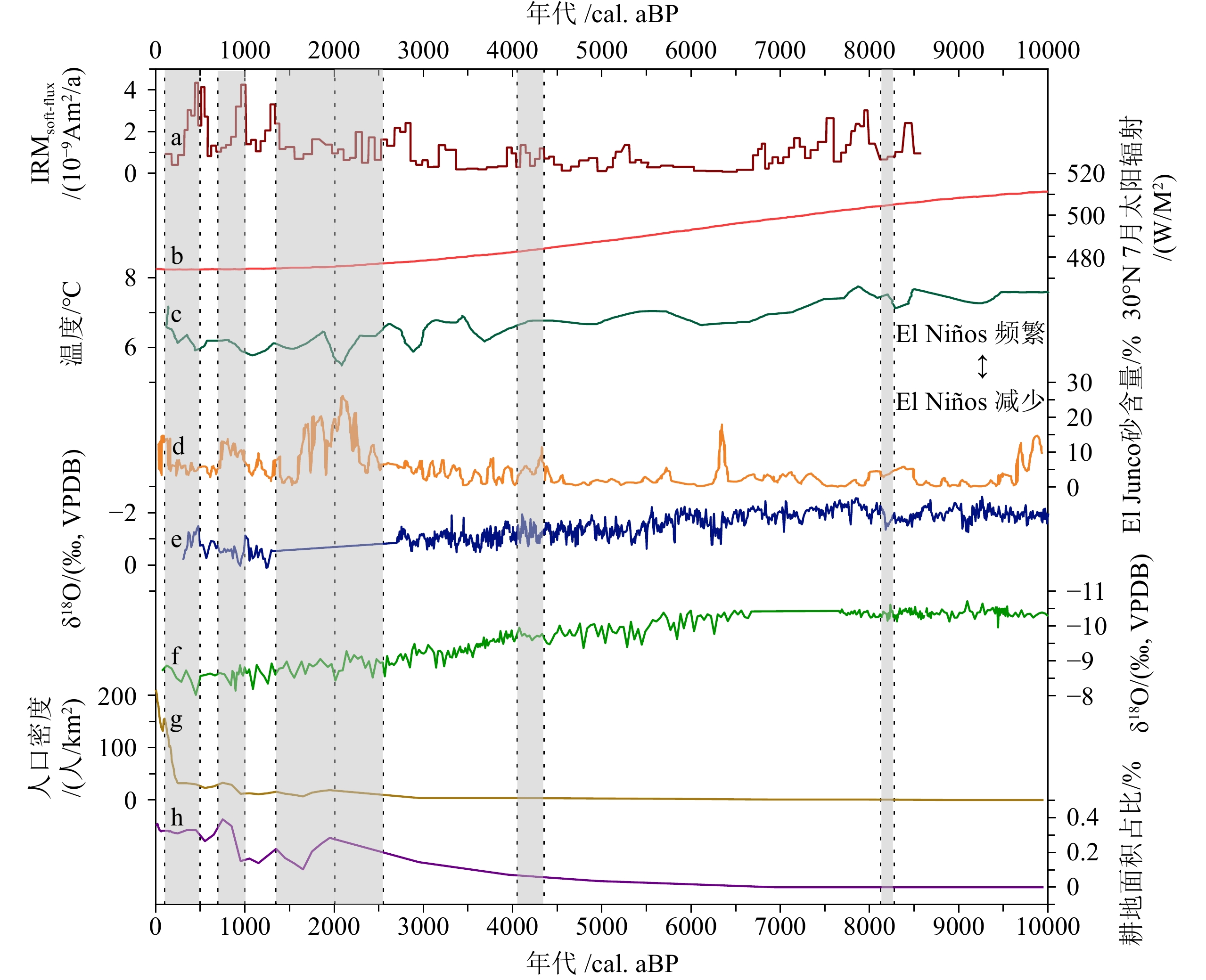
图 7 长江流域全新世洪水记录及其与气候和人类活动记录的对比
a: 和尚洞石笋HS4的IRMsoft-flux[101], b: 10 000 cal. aBP以来北半球夏季太阳辐射变化[120], c: Huang等重建的10 000以来气温变化[121],d: 10 000 cal. aBP以来El Junco粉砂记录的ENSO变化情况[122], e: 阿曼Qunf洞穴石笋所记录的δ18O数据指示西南季风变化[123], f: 湖北神农架地区三宝洞石笋所记录的δ18O指示东亚季风变化[124], g: HYDE3.0数据库10 000 cal. aBP以来江汉平原地区人口密度变化[125], h: HYDE3.0数据库10 000 cal. aBP以来江汉平原地区耕地垦殖率变化[125](图中6处阴影从左至右分别对应LIA-小冰期、MCA-中世纪气候异常、DACP-黑暗时代冷期、RWP-罗马暖期、4.2ka寒冷事件、8.2ka寒冷事件)。
Figure 7. The Holocene flood records in the Yangtze River Basin and their comparison with climatic and human activity records
a: IRMsoft-flux in stalagmite HS4, Heshang Cave[101], b: changes of solar radiation in the northern hemisphere during summer since 10000 cal.aBP[120], c: changes in temperature over the past 10,000 years as reconstructed by Huang et al.[121], d: changes of ENSO recorded in El Junco silt since 10000 cal. aBP[122], e: the δ18O data recorded by stalagmites in Qunf Cave, Oman, indicate changes in the southwest monsoon[123], f: the δ18O recorded by stalagmites in Sanbao Cave, Shennongjia area, Hubei Province indicates the change of East Asian monsoon[124],g: the change of population density in Jianghan Plain area since 10000 cal. aBP is obtained by HYDE3.0 database [125] ,h: changes of cropland cultivation ratio in Jianghan Plain since 10000 cal. aBP[125] (The six shadows in the figure correspond from left to right to LIA- Little Ice Age, MCA-Medieval Climate Anomaly, DACP-Dark Age Cold Period, RWP-Roman Warm Period, 4.2ka cold event, and 8.2ka cold event respectively).
表 1 长江流域极端洪水事件研究剖面位置及代用指标
Table 1 Site and proxy of research profiles of extreme flood events in Yangtze River Basin
序号 河段 剖面位置 经纬度 地质记录类型 文献来源 1 上游 中坝遗址 30.34°N、108.45°E 文化遗址 [12] 2 玉溪遗址 30.03°N、107.86°E 文化遗址 [13] 3 红桥村 30.68°N、103.88°E 文化遗址 [14] 4 金沙遗址 30.68°N、104.00°E 文化遗址 [15] 5 马街遗址 30.89°N、103.92°E 文化遗址 [16] 6 张家湾遗址 31.27°N、109.77°E 文化遗址 [17] 7 汉东城遗址 29.00°N、105.84°E 文化遗址 [18] 8 涪碛口遗址 29.20°N、108.75°E 文化遗址 [19] 9 中游 曲远河 32.87°N、110.62°E 自然剖面 [20] 10 尚家河 32.84°N、110.46°E 自然剖面 [21] 11 庹家洲 32.85°N、110.39°E 自然剖面 [22] 12 庹家湾 32.86°N、110.39°E 自然剖面 [23] 13 李家咀 32.82°N、110.77°E 自然剖面 [24] 14 晏家棚 32.83°N、110.43°E 自然剖面 [25] 15 归仙河口 32.82°N、110.54°E 自然剖面 [22] 16 弥陀寺 32.82°N、110.58°E 自然剖面 [26] 17 前坊村 32.83°N、110.98°E 自然剖面 [27] 18 辽瓦店 32.82°N、110.68°E 自然剖面 [24] 19 黄坪村 32.84°N、110.74°E 自然剖面 [28] 20 万春村 33.19°N、107.69°E 自然剖面 [29] 21 祥龙洞 33.00°N、106.33°E 自然剖面 [30] 22 尾笔村 30.39°N、114.47°E 自然剖面 [31] 23 焦家台子 32.82°N、110.16°E 自然剖面 [32] 24 罗家滩 32.78°N、109.35°E 自然剖面 [33] 25 楼子滩 33.46°N、110.51°E 自然剖面 [34] 26 泥沟口 32.89°N、109.53°E 自然剖面 [35] 27 立石村 30.20°N、105.30°E 自然剖面 [36] 28 新滩村 32.76°N、109.33°E 自然剖面 [37] 29 杜家沟 33.19°N、107.67°E 自然剖面 [38] 30 三房湾 30.46°N、113.04°E 自然剖面 [39] 31 江北农场二砖厂 30.18°N、112.34°E 自然剖面 [40] 32 消泗剖面 30.32°N、113.78°E 自然剖面 [41] 33 武汉 30.64°N、114.34°E 自然剖面 [42] 34 SK10 30.60°N、114.31°E 自然剖面 [43] 35 ZK145 30.66°N、114.44°E 自然剖面 [44-45] 36 钟桥遗址 30.31°N、112.27°E 文化遗址 [46] 37 中游 JH001 30.52°N、114.39°E 自然剖面 [47] 38 扬子江剖面 30.30°N、112.12°E 自然剖面 [48] 39 网湖 29.86°N、115.33°E 自然剖面 [49] 40 中洲子 29.80°N、112.75°E 自然剖面 [50] 41 天鹅洲 29.85°N、112.57°E 自然剖面 [51] 42 下游 修河 29.05°N、115.83°E 自然剖面 [52] 43 赣江 29.10°N、116.00°E 自然剖面 [52] 44 黄茅潭 29.80°N、116.35°E 自然剖面 [52] 45 大汊湖 29.10°N、116.01°E 自然剖面 [52] 46 东门镇林峰桥 32.14°N、118.70°E 自然剖面 [53] 47 宝华山-和平冲 32.16°N、119.02°E 自然剖面 [54] 48 宝华山 32.13°N、119.09°E 自然剖面 [54]  下载: 导出CSV
表 2 长江流域滞流沉积物与冲积平原沉积物宏观特征对比
Table 2 Comparison of macroscopic characteristics of slack water deposits in the Yangtze River Basin and overbank flooding deposits in the floodplain
下载: 导出CSV
-
[1] Baker V R. Paleoflood hydrology and extraordinary flood events[J]. Journal of Hydrology, 1987, 96(1-4):79-99. doi: 10.1016/0022-1694(87)90145-4
[2] 顾西辉, 张强, 孔冬冬. 中国极端降水事件时空特征及其对夏季温度响应[J]. 地理学报, 2016, 71(5):718-730 doi: 10.11821/dlxb201605002 GU Xihui, ZHANG Qiang, KONG Dongdong. Spatiotemporal patterns of extreme precipitation with their responses to summer temperature[J]. Acta Geographica Sinica, 2016, 71(5):718-730.] doi: 10.11821/dlxb201605002
[3] 王立琨, 陶祖钰, 杨阳, 等. 1998年长江洪水大暴雨的卫星云图分析[J]. 北京大学学报: 自然科学版, 2000, 36(1):87-94 WANG Likun, TAO Zuyu, YANG Yang, et al. Analysis of satellite image characters of severe storm rainfall during the flood of Yangtze River in 1998[J]. Acta Scicentiarum Naturalum Universitis Pekinesis, 2000, 36(1):87-94.]
[4] 新华社. 河南郑州"7·20"特大暴雨灾害调查报告公布[EB/OL]. [2-11-26]. http://www.gov.cn/xinwen/2022-01/21/content_5669723.htm. Xinhua News Agency. Investigation Report on "7·20" Heavy Rainstorm Disaster in Zhengzhou[EB/OL]. [2022-11-26]. http://www.gov.cn/xinwen/2022-01/21/content_5669723.htm.
[5] 余锡平, 单楷越. 华北平原极端暴雨洪水事件共性机制探讨及对策建议[J]. 中国水利, 2023, 58(18):24-28 doi: 10.3969/j.issn.1000-1123.2023.18.007 YU Xiping, SHAN Kaiyue. Common mechanisms and disaster prevention strategies for catastrophic rainfall and flooding events in the North China Plain[J]. China Water Resources, 2023, 58(18):24-28.] doi: 10.3969/j.issn.1000-1123.2023.18.007
[6] Yu S Y, Li W J, Zhou L, et al. Human disturbances dominated the unprecedentedly high frequency of Yellow River flood over the last millennium[J]. Science Advances, 2023, 9(8):eadf8576. doi: 10.1126/sciadv.adf8576
[7] 高启慧, 秦圆圆, 梁媚聪, 等. IPCC第六次评估报告综合报告解读及对我国的建议[J]. 环境保护, 2023, 51(Z2):82-84 GAO Qihui, QIN Yuanyuan, LIANG Meicong, et al. Interpretation of the main conclusions and suggestions of IPCC AR6 synthesis report[J]. Environmental Protection, 2023, 51(Z2):82-84.]
[8] Ely L L, Enzel Y, Baker V R, et al. A 5000-year record of extreme floods and climate change in the southwestern United States[J]. Science, 1993, 262(5132):410-412. doi: 10.1126/science.262.5132.410
[9] Ely L L. Response of extreme floods in the southwestern United States to climatic variations in the Late Holocene[J]. Geomorphology, 1997, 19(3-4):175-201. doi: 10.1016/S0169-555X(97)00014-7
[10] Gong D Y, Zhu J H, Wang S W. Flooding 1990s along the Yangtze River, has it concern of global warming?[J]. Journal of Geographical Sciences, 2001, 11(1):43-52. doi: 10.1007/BF02837375
[11] Trenberth K E, Dai A G, Rasmussen R M, et al. The changing character of precipitation[J]. Bulletin of the American Meteorological Society, 2003, 84(9):1205-1218. doi: 10.1175/BAMS-84-9-1205
[12] Zhu C, Zheng C G, Ma C M, et al. Identifying paleoflood deposits archived in Zhongba Site, the Three Gorges reservoir region of the Yangtze River, China[J]. Chinese Science Bulletin, 2005, 50(21):2493-2504. doi: 10.1007/BF03183641
[13] Zhu C, Ma C M, Xu W F, et al. Characteristics of paleoflood deposits archived in unit T0403 of Yuxi Site in the Three Gorges reservoir areas, China[J]. Chinese Science Bulletin, 2008, 53(S1):1-17. doi: 10.1007/s11434-008-5005-8
[14] Huang M, Zhu C, Ma C M, et al. The hongqiaocun site: the earliest evidence of ancient flood sedimentation of the water conservancy facilities in the Chengdu Plain, China[J]. CATENA, 2020, 185:104296. doi: 10.1016/j.catena.2019.104296
[15] Jia T J, Ma C M, Zhu C, et al. Depositional evidence of palaeofloods during 4.0-3.6 ka BP at the Jinsha site, Chengdu Plain, China[J]. Quaternary International, 2017, 440:78-89. doi: 10.1016/j.quaint.2016.07.008
[16] 朱诚, 徐佳佳, 黄明, 等. 成都平原马街遗址古洪水事件遗存考古发现与研究[J]. 地学前缘, 2021, 28(2):181-201 ZHU Cheng, XU Jiajia, HUANG Ming, et al. Archaeological discoveries and research on the remains of an ancient flood event at the Majie Site in the Chengdu Plain[J]. Earth Science Frontiers, 2021, 28(2):181-201.]
[17] 张芸, 朱诚. 长江三峡大宁河流域大昌地区环境考古[J]. 科学通报, 2008, 53(S1): 121-131 ZHANG Yun, ZHU Cheng. Environmental archaeology of the dachang region in the Daning Valley, the Three Gorges reservoir region of the Yangtze River, China[J]. Chinese Science Bulletin, 2008, 53(S1): 140-152.]
[18] 李兰, 白九江, 代玉彪. 重庆永川汉东城遗址地层记录的长江上游唐代洪水事件[J]. 第四纪研究, 2020, 40(2):556-567 doi: 10.11928/j.issn.1001-7410.2020.02.24 LI Lan, BAI Jiujiang, DAI Yubiao. Flood event recorded by the layer of handongcheng site and its significance to the Upper reaches of yangtze river[J]. Quaternary Sciences, 2020, 40(2):556-567.] doi: 10.11928/j.issn.1001-7410.2020.02.24
[19] 李杰, 郑卓, 邹后曦, 等. 重庆阿蓬江涪碛口遗址近3000年来环境变化研究[J]. 第四纪研究, 2011, 31(3):554-565 doi: 10.3969/j.issn.1001-7410.2011.03.19 LI Jie, ZHENG Zhuo, ZOU Houxi, et al. Evironmental research of a 3000 year record from fuqikou archaeological sites in apeng river, chongqing[J]. Quaternary Sciences, 2011, 31(3):554-565.] doi: 10.3969/j.issn.1001-7410.2011.03.19
[20] 郑树伟, 庞奖励, 黄春长, 等. 汉江上游郧县曲远河河口段全新世古洪水水文状态研究[J]. 长江流域资源与环境, 2013, 22(12):1608-1613 ZHENG Shuwei, PANG Jiangli, HUANG Chunchang, et al. Palaeoflood hydrological study in the quyuanhekou reach in the Upper reaches of the hanjiang river[J]. Resources and Environment in the Yangtze Basin, 2013, 22(12):1608-1613.]
[21] Zha X, Huang C C, Pang J L, et al. Reconstructing the palaeoflood events from slackwater deposits in the Upper reaches of Hanjiang River, China[J]. Quaternary International, 2015, 380-381:358-367. doi: 10.1016/j.quaint.2014.06.029
[22] Mao P N, Pang J L, Huang C C, et al. A multi-index analysis of the extraordinary paleoflood events recorded by slackwater deposits in the Yunxi Reach of the Upper Hanjiang River, China[J]. CATENA, 2016, 145:1-14. doi: 10.1016/j.catena.2016.05.016
[23] 查小春, 黄春长, 庞奖励, 等. 汉江上游郧西段全新世古洪水事件研究[J]. 地理学报, 2012, 67(5):671-680 doi: 10.11821/xb201205009 ZHA Xiaochun, HUANG Chunchang, PANG Jiangli, et al. The Holocene palaeoflood events in the yunxi reach in the Upper reaches of Hanjiang River[J]. Acta Geographica Sinica, 2012, 67(5):671-680.] doi: 10.11821/xb201205009
[24] 查小春, 黄春长, 庞奖励, 等. 汉江上游沉积记录的东汉时期古洪水事件考证研究[J]. 地理学报, 2017, 72(9):1634-1644 doi: 10.11821/dlxb201709008 ZHA Xiaochun, HUANG Chunchang, PANG Jiangli, et al. The palaeoflood events recorded by slackwater deposits in sedimentary profiles during the eastern Han Dynasty in the Upper reaches of the Hanjiang River[J]. Acta Geographica Sinica, 2017, 72(9):1634-1644.] doi: 10.11821/dlxb201709008
[25] 吉琳, 庞奖励, 黄春长, 等. 汉江上游晏家棚段全新世古洪水研究[J]. 地球科学进展, 2015, 30(4):487-494 JI Lin, PANG Jiangli, HUANG Chunchang, et al. Holocene palaeoflood studies of the Yanjiapeng reach in the Upper Hanjiang River, China[J]. Advances in Earth Science, 2015, 30(4):487-494.]
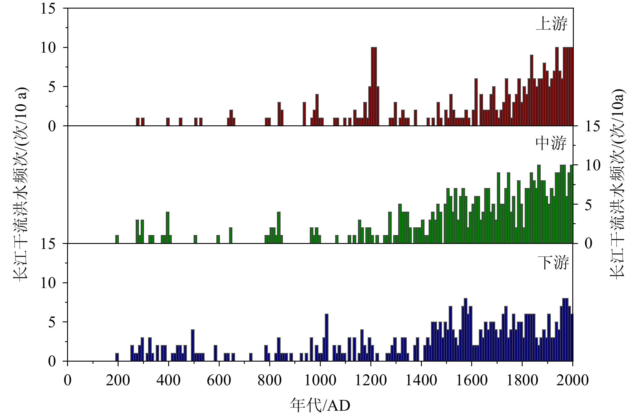
[26] 郑树伟, 庞奖励, 黄春长, 等. 湖北弥陀寺汉江段北宋时期古洪水研究[J]. 自然灾害学报, 2015, 24(3):153-160 ZHENG Shuwei, PANG Jiangli, HUANG Chunchang, et al. Study on palaeoflood in northern Song Period at Mituosi segment of Hanjiang River, Hubei province[J]. Journal of Natural Disasters, 2015, 24(3):153-160.]
[27] Huang C C, Pang J L, Zha X, et al. Extraordinary hydro-climatic events during the Period AD 200−300 recorded by slackwater deposits in the Upper Hanjiang River valley, China[J]. Palaeogeography, Palaeoclimatology, Palaeoecology, 2013, 374:274-283. doi: 10.1016/j.palaeo.2013.02.001
[28] 郑树伟, 庞奖励, 黄春长, 等. 汉江上游黄坪村段古洪水滞流沉积物研究及意义[J]. 土壤通报, 2014, 45(5):1025-1031 ZHENG Shuwei, PANG Jiangli, HUANG Chunchang, et al. The significance of palaeoflood slack water deposit in Huang Ping Site in Hanjiang River[J]. Chinese Journal of Soil Science, 2014, 45(5):1025-1031.]
[29] Guo Y Q, Huang C C, Zhou Y L, et al. Sedimentary record and luminescence chronology of palaeoflood events along the Gold Gorge of the Upper Hanjiang River, Middle Yangtze River Basin, China[J]. Journal of Asian Earth Sciences, 2018, 156:96-110. doi: 10.1016/j.jseaes.2017.12.034
[30] Tan L C, Cai Y J, Cheng H, et al. Centennial-to decadal-scale monsoon precipitation variations in the Upper Hanjiang River region, China over the past 6650 years[J]. Earth and Planetary Science Letters, 2018, 482:580-590. doi: 10.1016/j.jpgl.2017.11.044
[31] Guo Y Q, Huang C C, Zhou Y L, et al. Extraordinary flood events and the response to monsoonal climatic change during the last 3000 years along the Middle Yangtze River valley, China[J]. Palaeogeography, Palaeoclimatology, Palaeoecology, 2016, 462:70-84. doi: 10.1016/j.palaeo.2016.09.005
[32] 李晓刚, 黄春长, 庞奖励, 等. 汉江上游白河段万年尺度洪水水文学研究[J]. 地理科学, 2012, 32(8):971-978 LI Xiaogang, HUANG Chunchang, PANG Jiangli, et al. Palaeoflood hydrological study in the baihe reach in the Upper reaches of the Hanjiang River[J]. Scientia Geographica Sinica, 2012, 32(8):971-978.]
[33] Zhang Y Z, Huang C C, Pang J L, et al. Holocene paleofloods related to climatic events in the Upper reaches of the Hanjiang River valley, Middle Yangtze River Basin, China[J]. Geomorphology, 2013, 195:1-12. doi: 10.1016/j.geomorph.2013.03.032
[34] Li X G, Huang C C, Zhang Y Z, et al. Hydrological reconstruction of extreme palaeoflood events 9000-8500 a BP in the Danjiang River Valley, tributary of the Danjiangkou Reservoir, China[J]. Arabian Journal of Geosciences, 2020, 13:137. doi: 10.1007/s12517-020-5132-3
[35] Wang L S, Huang C C, Pang J L, et al. Paleofloods recorded by slackwater deposits in the Upper reaches of the Hanjiang River valley, Middle Yangtze River Basin, China[J]. Journal of Hydrology, 2014, 519:1249-1256. doi: 10.1016/j.jhydrol.2014.08.002
[36] 周亮, 黄春长, 周亚利, 等. 汉江上游安康东段古洪水事件光释光测年研究[J]. 地质学报, 2013, 87(11):1703-1714 ZHOU Liang, HUANG Chunchang, ZHOU Yali, et al. OSL dating of the palaeoflood events in the ankang east reach in the Upper Hanjiang River valley[J]. Acta Geologica Sinica, 2013, 87(11):1703-1714.]
[37] Guo Y Q, Huang C C, Pang J L, et al. Investigating extreme flood response to Holocene palaeoclimate in the Chinese monsoonal zone: a palaeoflood case study from the Hanjiang River[J]. Geomorphology, 2015, 238:187-197. doi: 10.1016/j.geomorph.2015.03.014
[38] Mao P N, Pang J L, Huang C C, et al. Paleoflood evidence for an Upper limit of the maximum flood magnitudes along the Gold Gorge, the Upper Hanjiang River, China[J]. CATENA, 2022, 212:106111. doi: 10.1016/j.catena.2022.106111
[39] Jia M, Li C, Mao X, et al. Climate–human–environment interactions in the middle Yangtze Basin (central China) during the middle Holocene, based on pollen and geochemical records from the Sanfangwan Site[J]. Catena, 2021, 204:105357. doi: 10.1016/j.catena.2021.105357
[40] 张玉芬, 李长安, 陈亮, 等. 基于磁组构特征的江汉平原全新世古洪水事件[J]. 地球科学: 中国地质大学学报, 2009, 34(6):985-992 doi: 10.3799/dqkx.2009.112 ZHANG Yufen, LI Chang’an, CHEN Liang, et al. Magnetic fabric of Holocene palaeo-floods events in Jianghan plain[J]. Earth Science: Journal of China University of Geosciences, 2009, 34(6):985-992.] doi: 10.3799/dqkx.2009.112
[41] 陈亮, 张玉芬, 李长安, 等. 江汉平原消泗剖面沉积物磁组构特征[J]. 工程地球物理学报, 2007, 4(3):190-195 doi: 10.3969/j.issn.1672-7940.2007.03.005 CHEN Liang, ZHANG Yufen, LI Chang’an, et al. Magnetic fabric characteristics of the sediments in the xiaosi profile of Jianghan Plain of Hubei province[J]. Chinese Journal of Engineering Geophysics, 2007, 4(3):190-195.] doi: 10.3969/j.issn.1672-7940.2007.03.005
[42] Liu X J, Min F Y, Kettner A J. The impact of large to extreme flood events on floodplain evolution of the Middle and Lower reaches of the Yangtze River, China[J]. CATENA, 2019, 176:394-409. doi: 10.1016/j.catena.2019.01.027
[43] 张跞颖, 李长安, 张玉芬, 等. 长江武汉段4.5~2.5 ka沉积地层与古洪水标志识别[J]. 地质论评, 2019, 65(4):973-982 ZHANG Luoying, LI Chang'an, ZHANG Yufen, et al. Sedimentary strata and paleoflood identification indexes of Wuhan section, Yangtze River, during 4.5~2.5 ka BP[J]. Geological Review, 2019, 65(4):973-982.]
[44] 熊智秋, 张玉芬, 毛欣, 等. 武汉地区ZK145钻孔沉积物磁性特征及对古洪水的记录[J]. 地球科学, 2020, 45(2):663-671 XIONG Zhiqiu, ZHANG Yufen, MAO Xin, et al. Magnetic characteristics of ZK145 borehole sediments in Wuhan area and its[J]. Earth Science, 2020, 45(2):663-671.]
[45] 朱海, 张玉芬, 李长安. 端元分析在长江武汉段古洪水识别中的应用[J]. 沉积学报, 2020, 38(2):297-305 ZHU Hai, ZHANG Yufen, LI Chang'an. The application of end-member analysis in identification of paleo-floods in wuhan section of the Yangtze River[J]. Acta Sedimentologica Sinica, 2020, 38(2):297-305.]
[46] 吴立, 朱诚, 李枫, 等. 江汉平原钟桥遗址地层揭示的史前洪水事件[J]. 地理学报, 2015, 70(7):1149-1164 doi: 10.11821/dlxb201507011 WU Li, ZHU Cheng, LI Feng, et al. Prehistoric flood events recorded at the Zhongqiao neolithic site in the Jianghan Plain, Central China[J]. Acta Geographica Sinica, 2015, 70(7):1149-1164.] doi: 10.11821/dlxb201507011
[47] Guan S, Yang Q, Li Y N, et al. River flooding response to ENSO-related monsoon precipitation: evidence from Late Holocene core sediments in the Jianghan Plain[J]. Palaeogeography, Palaeoclimatology, Palaeoecology, 2022, 589:110834. doi: 10.1016/j.palaeo.2022.110834
[48] 罗淑元, 郑丽匀, 曹向明, 等. 长江中游河漫滩沉积序列对洪水事件的指示: 以荆州扬子江剖面为例[J]. 人民长江, 2021, 52(1):6-12 LUO Shuyuan, ZHENG Liyun, CAO Xiangming, et al. Indication of flood events based on floodplain sedimentary sequence in Middle reaches of Changjiang River since 19th century: case of Yangzijiang profile in Jingzhou city[J]. Yangtze River, 2021, 52(1):6-12.]
[49] 史小丽, 秦伯强. 近百年来长江中游网湖沉积物粒度特征及其环境意义[J]. 海洋地质与第四纪地质, 2009, 29(2):117-122 SHI Xiaoli, QIN Boqiang. Grain-size characteristics and their environmental significance of wanghu lake sediments in the Middle reach of yangtze river[J]. Marine Geology & Quaternary Geology, 2009, 29(2):117-122.]
[50] 袁世飞. 近百年来长江中游牛轭湖沉积记录的高分辨率环境演变研究[D]. 上海师范大学硕士学位论文, 2014 YUAN Shifei. High-resolution environmental evolution of Oxbow Lake sedimentary records in the Middle reaches of the Yangtze River in the last hundred years[D]. Master Dissertation of Shanghai Normal University, 2014.]
[51] 王峰. 近百年来长江中游牛轭湖沉积特征及其环境意义: 以长江荆江段牛轭湖群为例[D]. 上海师范大学硕士学位论文, 2015 WANG Feng. Sedimentary characteristics and environmental significance of Oxbow Lake in the Middle reaches of Yangtze River in the last hundred years[D]. Master Dissertation of Shanghai Normal University, 2015.]
[52] 曹向明. 长江中下游地区高分辨率河湖相沉积记录的洪水事件及其规律[D]. 江西师范大学硕士学位论文, 2020 CAO Xiangming. Flood events recorded by high-resolution fluvial and lacustrine deposits in the Middle and Lower reaches of the yangtze river and their properties[D]. Master Dissertation of Jiangxi Normal University, 2020.]
[53] 朱诚, 于世永, 史威, 等. 南京江北地区全新世沉积与古洪水研究[J]. 地理研究, 1997, 16(4):23-30 ZHU Cheng, YU Shiyong, SHI Wei, et al. Holocene deposits and paleo-floods on the north bank of the Yangtze River, Nanjing area[J]. Geographical Research, 1997, 16(4):23-30.]
[54] Yu S Y, Zhu C, Wang F B. Radiocarbon constraints on the Holocene flood deposits of the Ning‐Zhen Mountains, Lower Yangtze River area of China[J]. Journal of Quaternary Science, 2003, 18(6):521-525. doi: 10.1002/jqs.767
[55] Baker V R. Paleoflood hydrologic techniques for the extension of streamflow records[J]. Transportation Research Record, 1983, 4(922):18-23.
[56] Kochel R C, Baker V R. Paleoflood hydrology[J]. Science, 1982, 215(4531):353-361. doi: 10.1126/science.215.4531.353
[57] Baker V R, Kochel R C, Patton P C. Flood geomorphology[M]. Wiley, 1988.
[58] Wright M N, Bird B W, Gibson D K, et al. Fluvial responses to Late Holocene hydroclimate variability in the midcontinental United States[J]. Quaternary Science Reviews, 2023, 301:107939. doi: 10.1016/j.quascirev.2022.107939
[59] Macklin M G, Lewin J. River sediments, great floods and centennial‐scale Holocene climate change[J]. Journal of Quaternary Science, 2003, 18(2):101-105. doi: 10.1002/jqs.751
[60] Wilhelm B, Arnaud F, Sabatier P, et al. Palaeoflood activity and climate change over the last 1400 years recorded by lake sediments in the north‐west European Alps[J]. Journal of Quaternary Science, 2013, 28(2):189-199. doi: 10.1002/jqs.2609
[61] 杨劲松, 刘林敬, 赵华, 等. 黄河故道区晚全新世沉积记录及其对洪水灾害事件的响应[J]. 中国地质, 2023, 50(4):1004-1015 doi: 10.12029/gc20220323001 YANG Jinsong, LIU Linjing, ZHAO Hua, et al. Late Holocene sedimentary records along the abandoned channel areas of the Yellow River and their response to flood hazards[J]. Geology in China, 2023, 50(4):1004-1015.] doi: 10.12029/gc20220323001
[62] Huang C C, Pang J L, Zha X, et al. Holocene palaeoflood events recorded by slackwater deposits along the Lower Jinghe River valley, Middle Yellow River Basin, China[J]. Journal of Quaternary Science, 2012, 27(5):485-493. doi: 10.1002/jqs.2536
[63] Baker V R. Paleoflood hydrology: origin, progress, prospects[J]. Geomorphology, 2008, 101(1-2):1-13. doi: 10.1016/j.geomorph.2008.05.016
[64] 谢悦波, 杨达源. 古洪水平流沉积基本特征[J]. 河海大学学报: 自然科学版, 1998, 26(6):5-10 XIE Yuebo, YANG Dayuan. Basic characteristics of paleoflood slack water deposits[J]. Journal of Hohai University: Natural Sciences, 1998, 26(6):5-10.]
[65] Jarrett R D. Paleohydrology and its value in analyzing floods and droughts[J]. US Geological Survey Water-Supplementary Paper, 1991, 2375:105-116.
[66] Guo Y Q, Huang C C, Pang J L, et al. Reconstruction palaeoflood hydrology using slackwater flow depth method in the Yanhe River valley, Middle Yellow River Basin, China[J]. Journal of Hydrology, 2017, 544:156-171. doi: 10.1016/j.jhydrol.2016.11.017
[67] 吴帅虎, 庞奖励, 黄春长, 等. 汉江上游河谷古洪水滞流沉积物特征[J]. 土壤通报, 2013, 44(2):271-276 WU Shuaihu, PANG Jiangli, HUANG Chunchang, et al. The palaeoflood slackwater sediments feature in the valley of the Upper reaches of the Hanjiang River[J]. Chinese Journal of Soil Science, 2013, 44(2):271-276.]
[68] 李晓刚, 黄春长, 庞奖励. 丹江上游全新世早期古洪水滞流沉积物粒度特征研究[J]. 干旱区地理, 2014, 37(4):646-655 LI Xiaogang, HUANG Chunchang, PANG Jiangli. Grain-size characteristics of the early Holocene flood Slackwater deposits in the Upper reaches of Danjiang River[J]. Arid Land Geography, 2014, 37(4):646-655.]
[69] Wohl E. An integrative conceptualization of floodplain storage[J]. Reviews of Geophysics, 2021, 59(2):e2020RG000724. doi: 10.1029/2020RG000724
[70] Normally N R. Definition and identification of channel and overbank deposits and their respective roles in flood plain Formation[J]. The Professional Geographer, 1967, 19(1):1-4. doi: 10.1111/j.0033-0124.1967.00001.x
[71] 杨劲松, 王永, 尹金辉, 等. 我国冲积平原区洪水事件重建研究进展及展望[J]. 地球科学, 2022, 47(11):3944-3959 YANG Jinsong, WANG Yong, YIN Jinhui, et al. Progress and prospects in reconstruction of flood events in Chinese alluvial plains[J]. Earth Science, 2022, 47(11):3944-3959.]
[72] 张振克, 王苏民. 中国湖泊沉积记录的环境演变: 研究进展与展望[J]. 地球科学进展, 1999, 14(4):417-422 doi: 10.3321/j.issn:1001-8166.1999.04.018 ZHANG Zhenke, WANG Sumin. Advance and prospects of lake sediments and environmental changes study in China[J]. Advance in Earth Sciences, 1999, 14(4):417-422.] doi: 10.3321/j.issn:1001-8166.1999.04.018
[73] 张凌华. 长江南京—镇江段现代河漫滩沉积特征与环境意义[D]. 南京大学博士学位论文, 2015 ZHANG Linghua. Sediment characteristics and overbank sediments in the Nanjing-Zhenjiang reaches of the Yangtze River and their environmental implication[D]. Doctor Dissertation of Nanjing University, 2015.]
[74] 何报寅. 江汉平原湖泊的成因类型及其特征[J]. 华中师范大学学报: 自然科学版, 2002, 36(2):241-244 HE Baoyin. The origin types and their characteristics of the lakes in Jianghan Plain[J]. Journal of Central China Normal University: Natural Science, 2002, 36(2):241-244.]
[75] 赵炳炎, 胡建芳, 刘丰豪, 等. 长江下游南漪湖沉积记录的全新世以来温度变化[J]. 第四纪研究, 2021, 41(4):1044-1055 doi: 10.11928/j.issn.1001-7410.2021.04.14 ZHAO Bingyan, HU Jianfang, LIU Fenghao, et al. Variation of temperature in lake nanyi sediments from the Lower yangtze river region since the last 12.0 ka B. P.[J]. Quaternary Sciences, 2021, 41(4):1044-1055.] doi: 10.11928/j.issn.1001-7410.2021.04.14
[76] Wu L, Zhu C, Ma C M, et al. Mid-Holocene palaeoflood events recorded at the Zhongqiao Neolithic cultural site in the Jianghan Plain, Middle Yangtze River Valley, China[J]. Quaternary Science Reviews, 2017, 173:145-160. doi: 10.1016/j.quascirev.2017.08.018
[77] Wilhelm B, Ballesteros Cánovas J A, Macdonald N, et al. Interpreting historical, botanical, and geological evidence to aid preparations for future floods[J]. WIREs Water, 2019, 6(1):e1318. doi: 10.1002/wat2.1318
[78] 朱诚, 于世永, 卢春成. 长江三峡及江汉平原地区全新世环境考古与异常洪涝灾害研究[J]. 地理学报, 1997, 52(3):268-278 doi: 10.3321/j.issn:0375-5444.1997.03.010 ZHU Cheng, YU Shiyong, LU Chuncheng. The study of Holocene environmental archaeology and extreme flood disaster in the three gorges of the Changjiang River and the Jianghan Plain[J]. Acta Geographica Sinica, 1997, 52(3):268-278.] doi: 10.3321/j.issn:0375-5444.1997.03.010
[79] 吴立. 江汉平原中全新世古洪水事件环境考古研究[D]. 南京大学博士学位论文, 2013 WU Li. Environmental Archaeology of the Mid-Holocene palaeofloods in the Jianghan Plain, Central China[D]. Doctor Dissertation of Nanjing University, 2013.]
[80] 连丽聪, 凌超豪, 李晓峰, 等. 河漫滩沉积体系对洪水事件的指示: 以修河为例[J]. 沉积学报, 2019, 37(1):135-142 LIAN Licong, LING Chaohao, LI Xiaofeng, et al. Indicator of flood events based on floodplain sediments: a case study of Xiu River[J]. Acta Sedimentologica Sinica, 2019, 37(1):135-142.]
[81] 谢悦波, 王文辉, 王平. 古洪水平流沉积粒度特征[J]. 水文, 2000, 20(4):18-20 doi: 10.3969/j.issn.1000-0852.2000.04.005 XIE Yuebo, WANG Wenhui, WANG Ping. Characteristics of grain size for palaeoflood slackwater deposits[J]. Journal of China Hydrology, 2000, 20(4):18-20.] doi: 10.3969/j.issn.1000-0852.2000.04.005
[82] 谢远云, 李长安, 王秋良, 等. 江汉平原近3 000年来古洪水事件的沉积记录[J]. 地理科学, 2007, 27(1):81-84 doi: 10.3969/j.issn.1000-0690.2007.01.013 XIE Yuanyun, LI Chang’an, WANG Qiuliang, et al. Sedimentary records of paleoflood events during the last 3000 years in Jianghan Plain[J]. Scientia Geographica Sinica, 2007, 27(1):81-84.] doi: 10.3969/j.issn.1000-0690.2007.01.013
[83] 李长安, 张玉芬. 长江中游洪水沉积特征与标志初步研究[J]. 水科学进展, 2004, 15(4):485-488 doi: 10.3321/j.issn:1001-6791.2004.04.015 LI Chang'an, ZHANG Yufen. Flood sedimental characteristic and its mark on the Middle reaches of Yangtze River[J]. Advances in Water Science, 2004, 15(4):485-488.] doi: 10.3321/j.issn:1001-6791.2004.04.015
[84] 张灿, 周爱锋, 张晓楠, 等. 湖泊沉积记录的古洪水事件识别及与气候关系[J]. 地理科学进展, 2015, 34(7):898-908 doi: 10.18306/dlkxjz.2015.07.011 ZHANG Can, ZHOU Aifeng, ZHANG Xiaonan, et al. Identification of Paleaoflood events by lacustrine archives and their links to climatic conditions[J]. Progress in Geography, 2015, 34(7):898-908.] doi: 10.18306/dlkxjz.2015.07.011
[85] 吴霜, 刘倩, 曹向明, 等. 赣北黄茅潭湖泊沉积记录的240年以来古洪水事件[J]. 地理科学进展, 2017, 36(11):1413-1422 doi: 10.18306/dlkxjz.2017.11.010 WU Shuang, LIU Qian, CAO Xiangming, et al. A 240-year sedimentary record of paleoflood events from the Huangmaotan Lake, northern Jiangxi province[J]. Progress in Geography, 2017, 36(11):1413-1422.] doi: 10.18306/dlkxjz.2017.11.010
[86] Gilli A, Anselmetti F S, Glur L, et al. Lake sediments as archives of recurrence rates and intensities of past flood events[M]//Schneuwly-Bollschweiler M, Stoffel M, Rudolf-Miklau F. Dating Torrential Processes on Fans and Cones: Methods and Their Application for Hazard and Risk Assessment. Dordrecht: Springer, 2013: 225-242.
[87] Brown S L, Bierman P R, Lini A, et al. 10 000 yr record of extreme hydrologic events[J]. Geology, 2000, 28(4):335-338. doi: 10.1130/0091-7613(2000)28<335:YROEHE>2.0.CO;2
[88] Osleger D A, Heyvaert A C, Stoner J S, et al. Lacustrine turbidites as indicators of Holocene storminess and climate: Lake Tahoe, California and Nevada[J]. Journal of Paleolimnology, 2009, 42(1):103-122. doi: 10.1007/s10933-008-9265-8
[89] Fairchild I J, Treble P C. Trace elements in speleothems as recorders of environmental change[J]. Quaternary Science Reviews, 2009, 28(5-6):449-468. doi: 10.1016/j.quascirev.2008.11.007
[90] Cheng H, Edwards R L, Broecker W S, et al. Ice age terminations[J]. Science, 2009, 326(5950):248-252. doi: 10.1126/science.1177840
[91] Tan L C, Cai Y J, Cheng H, et al. Climate significance of speleothem δ18O from central China on decadal timescale[J]. Journal of Asian Earth Sciences, 2015, 106:150-155. doi: 10.1016/j.jseaes.2015.03.008
[92] Dykoski C A, Edwards R L, Cheng H, et al. A high-resolution, absolute-dated Holocene and deglacial Asian monsoon record from Dongge Cave, China[J]. Earth and Planetary Science Letters, 2005, 233(1-2):71-86. doi: 10.1016/j.jpgl.2005.01.036
[93] Wang X F, Edwards R L, Auler A S, et al. Hydroclimate changes across the Amazon lowlands over the past 45, 000 years[J]. Nature, 2017, 541(7636):204-207. doi: 10.1038/nature20787
[94] Tan L C, Cai Y J, An Z S, et al. A Chinese cave links climate change, social impacts and human adaptation over the last 500 years[J]. Scientific Reports, 2015, 5(1):12284. doi: 10.1038/srep12284
[95] Wang Z J, Chen S T, Wang Y J, et al. A high-resolution stalagmite record from Luoshui Cave, Central China over the past 23.5 kyr[J]. Quaternary Science Reviews, 2022, 282:107443. doi: 10.1016/j.quascirev.2022.107443
[96] Xie S C, Evershed R P, Huang X Y, et al. Concordant monsoon-driven postglacial hydrological changes in peat and stalagmite records and their impacts on prehistoric cultures in central China[J]. Geology, 2013, 41(8):827-830. doi: 10.1130/G34318.1
[97] Lascu I, Feinberg J M. Speleothem magnetism[J]. Quaternary Science Reviews, 2011, 30(23-24):3306-3320. doi: 10.1016/j.quascirev.2011.08.004
[98] Maher B A, Thompson R. Paleorainfall reconstructions from pedogenic magnetic susceptibility variations in the Chinese loess and paleosols[J]. Quaternary Research, 1995, 44(3):383-391. doi: 10.1006/qres.1995.1083
[99] Strauss B E, Strehlau J H, Lascu I, et al. The origin of magnetic remanence in stalagmites: Observations from electron microscopy and rock magnetism[J]. Geochemistry, Geophysics, Geosystems, 2013, 14(12):5006-5025. doi: 10.1002/2013GC004950
[100] Bourne M D, Feinberg J M, Strauss B E, et al. Long-term changes in precipitation recorded by magnetic minerals in speleothems[J]. Geology, 2015, 43(7):595-598. doi: 10.1130/G36695.1
[101] Zhu Z M, Feinberg J M, Xie S C, et al. Holocene ENSO-related cyclic storms recorded by magnetic minerals in speleothems of central China[J]. Proceedings of the National Academy of Sciences of the United States of America, 2017, 114(5):852-857.
[102] 黄忠恕. 长江流域历史水旱灾害分析[J]. 人民长江, 2003, 34(2):1-3 doi: 10.3969/j.issn.1001-4179.2003.02.001 HUANG Zhongshu. Analysis on historic flood and drought disasters of the Yangtze river[J]. Yangtze River, 2003, 34(2):1-3.] doi: 10.3969/j.issn.1001-4179.2003.02.001
[103] 李雨凡, 周亮, 于世永, 等. 过去两千年长江干流历史洪水事件的时空变化研究[J]. 地球与环境, 2022, 50(2):241-251 LI Yufan, ZHOU Liang, YU Shiyong, et al. Temporal and spatial variations of flood events of the Yangtze River over the past 2000 years[J]. Earth and Environment, 2022, 50(2):241-251.]
[104] 温克刚. 中国气象灾害大典: (重庆卷)[M]. 北京: 气象出版社, 2008 WEN Kegang. The Meteorological Disaster Encyclopedia of China: Chongqing Volume[M]. Beijing: China Meteorological Press, 2008.]
[105] 廖淦标, 范代读. 全球变暖是否导致台风增强: 古风暴学研究进展与启示[J]. 科学通报, 2008, 53(13):1489-1502 doi: 10.3321/j.issn:0023-074X.2008.13.001 LIAO Ganbiao, FAN Daidu. Perspectives on the linkage between typhoon activity and global warming from recent research advances in paleotempestology[J]. Chinese Science Bulletin, 2008, 53(13):1489-1502.] doi: 10.3321/j.issn:0023-074X.2008.13.001
[106] Baker V R, Kochel R C, Patton P C, et al. Palaeohydrologic analysis of Holocene flood slack‐water sediments[J]. Modern and ancient fluvial systems, 1983: 229-239.
[107] Benito G, Sánchez-Moya Y, Sopeña A. Sedimentology of high-stage flood deposits of the Tagus River, Central Spain[J]. Sedimentary Geology, 2003, 157(1-2):107-132. doi: 10.1016/S0037-0738(02)00196-3
[108] 杨轶文, 杨青惠. 窟野河流域水文特性分析[J]. 水资源与水工程学报, 2006, 17(1):57-60,64 doi: 10.3969/j.issn.1672-643X.2006.01.013 YANG Yiwen, YANG Qinghui. Analysis of hydrologic characteristics in Kuye river Basin[J]. Journal of Water Resources and Water Engineering, 2006, 17(1):57-60,64.] doi: 10.3969/j.issn.1672-643X.2006.01.013
[109] Li X G, Huang C C, Pang J L, et al. Sedimentary and hydrological studies of the Holocene palaeofloods in the Shanxi-Shaanxi Gorge of the Middle Yellow River, China[J]. International Journal of Earth Sciences, 2015, 104(1):277-288. doi: 10.1007/s00531-014-1067-9
[110] Storozum M, Lu P, Wang S Y, et al. Geoarchaeological evidence of the AD 1642 Yellow River flood that destroyed Kaifeng, a former capital of dynastic China[J]. Scientific Reports, 2020, 10(1):3765. doi: 10.1038/s41598-020-60169-1
[111] Crookshanks S, Gilbert R. Continuous, diurnally fluctuating turbidity currents in Kluane Lake, Yukon Territory[J]. Canadian Journal of Earth Sciences, 2008, 45(10):1123-1138. doi: 10.1139/E08-058
[112] Wilhelm B, Amann B, Corella J P, et al. Reconstructing paleoflood occurrence and magnitude from lake sediments[J]. Quaternary, 2022, 5(1):9. doi: 10.3390/quat5010009
[113] Wilhelm B, Vogel H, Crouzet C, et al. Frequency and intensity of palaeofloods at the interface of Atlantic and Mediterranean climate domains[J]. Climate of the Past, 2016, 12(2):299-316. doi: 10.5194/cp-12-299-2016
[114] 周凤琴. 荆江近5000年来洪水位变迁的初步探讨[J]. 历史地理, 1986, 6(1):46-53 ZHOU Fengqin. Preliminary study on flood level change in recent 5000 year in Jingjiang River[J]. Historical Geography, 1986, 6(1):46-53.]
[115] Knox J C. Sensitivity of modern and Holocene floods to climate change[J]. Quaternary Science Reviews, 2000, 19(1-5):439-457. doi: 10.1016/S0277-3791(99)00074-8
[116] 葛兆帅, 杨达源, 李徐生, 等. 晚更新世晚期以来的长江上游古洪水记录[J]. 第四纪研究, 2004, 24(5):555-560 doi: 10.3321/j.issn:1001-7410.2004.05.012 GE Zhaoshuai, YANG Dayuan, LI Xusheng, et al. The paleoflooding record along the up-reaches of the Changjiang River since the Late Pleistocene Epoch[J]. Quaternary Sciences, 2004, 24(5):555-560.] doi: 10.3321/j.issn:1001-7410.2004.05.012
[117] 王娜, 查小春, 黄春长, 等. 汉江上游晚冰期以来古洪水事件发生的气候背景分析[J]. 长江流域资源与环境, 2020, 29(10):2250-2260 WANG Na, ZHA Xiaochun, HUANG Chunchang, et al. Climate background about the palaeoflood events since Lateglacial Epoch in the Upper reaches of Hanjiang River, China[J]. Resources and Environment in the Yangtze Basin, 2020, 29(10):2250-2260.]
[118] 朱诚, 于世永, 张兵, 等. 南京宝华山地区全新世沉积环境研究[J]. 地理科学, 1997, 17(3):253-258 ZHU Cheng, YU Shiyong, ZHANG Bing, et al. Study on Holocene sedimentary environment in Baohuashan area of Nanjing[J]. Scientia Geographica Sinica, 1997, 17(3):253-258.]
[119] 王江月, 白伟明, 王照波, 等. 中国东部地区全新世气候演化及其与气候事件的对应性[J]. 海洋地质与第四纪地质, 2022, 42(2):167-177 WANG Jiangyue, BAI Weiming, WANG Zhaobo, et al. The Holocene climatic evolution in eastern China and its bearing on climatic events[J]. Marine Geology & Quaternary Geology, 2022, 42(2):167-177.]
[120] Berger A, Loutre M F. Insolation values for the climate of the last 10 million years[J]. Quaternary Science Reviews, 1991, 10(4):297-317. doi: 10.1016/0277-3791(91)90033-Q
[121] Huang X Y, Meyers P A, Jia C L, et al. Paleotemperature variability in central China during the last 13 ka recorded by a novel microbial lipid proxy in the Dajiuhu peat deposit[J]. The Holocene, 2013, 23(8):1123-1129. doi: 10.1177/0959683613483617
[122] Conroy J L, Overpeck J T, Cole J E, et al. Holocene changes in eastern tropical Pacific climate inferred from a Galápagos lake sediment record[J]. Quaternary Science Reviews, 2008, 27(11-12):1166-1180. doi: 10.1016/j.quascirev.2008.02.015
[123] Fleitmann D, Burns S J, Mangini A, et al. Holocene ITCZ and Indian monsoon dynamics recorded in stalagmites from Oman and Yemen (Socotra)[J]. Quaternary Science Reviews, 2007, 26(1-2):170-188. doi: 10.1016/j.quascirev.2006.04.012
[124] Dong J G, Wang Y J, Cheng H, et al. A high-resolution stalagmite record of the Holocene East Asian monsoon from Mt Shennongjia, central China[J]. The Holocene, 2010, 20(2):257-264. doi: 10.1177/0959683609350393
[125] Klein Goldewijk K, Beusen A, Doelman J, et al. Anthropogenic land use estimates for the Holocene–HYDE 3.2[J]. Earth System Science Data, 2017, 9(2):927-953. doi: 10.5194/essd-9-927-2017
[126] 施雅风, 姜彤, 苏布达, 等. 1840年以来长江大洪水演变与气候变化关系初探[J]. 湖泊科学, 2004, 16(4):289-297 doi: 10.3321/j.issn:1003-5427.2004.04.001 SHI Yafeng, JIANG Tong, SU Buda, et al. Preliminary analysis on the relation between the evolution of heavy floods in the Yangtze River catchment and the climate changes since 1840[J]. Journal of Lake Sciences, 2004, 16(4):289-297.] doi: 10.3321/j.issn:1003-5427.2004.04.001
[127] 葛兆帅. 长江上游全新世特大洪水对西南季风变化的响应[J]. 地理研究, 2009, 28(3):592-600 doi: 10.3321/j.issn:1000-0585.2009.03.004 GE Zhaoshuai. The response of Holocene extreme floods in the Upper Changjiang River to changes of southwest monsoon[J]. Geographical Research, 2009, 28(3):592-600.] doi: 10.3321/j.issn:1000-0585.2009.03.004
[128] Trenberth K E. Changes in precipitation with climate change[J]. Climate Research, 2011, 47(1-2):123-138.
[129] Xie S P, Philander S G H. A coupled ocean‐atmosphere model of relevance to the ITCZ in the eastern Pacific[J]. Tellus A: Dynamic Meteorology and Oceanography, 1994, 46(4):340-350. doi: 10.3402/tellusa.v46i4.15484
[130] Bischoff T, Schneider T. Energetic constraints on the position of the intertropical convergence zone[J]. Journal of Climate, 2014, 27(13):4937-4951. doi: 10.1175/JCLI-D-13-00650.1
[131] 李晓峰, 郭品文, 董丽娜, 等. 夏季索马里急流的建立及其影响机制[J]. 南京气象学院学报, 2006, 29(5):599-605 LI Xiaofeng, GUO Pinwen, DONG Lina, et al. Onset process of summer somali jet and the possible influenced mechanism[J]. Journal of Nanjing Institute of Meteorology, 2006, 29(5):599-605.]
[132] Chang W Y B, King G. Centennial climate changes and their global associations in the Yangtze River (Chang Jiang) Delta, China and subtropical Asia[J]. Climate Research, 1994, 4(2):95-103.
[133] Dilley M, Heyman B N. ENSO and disaster: droughts, floods and El Niño/southern Oscillation warm events[J]. Disasters, 1995, 19(3):181-193. doi: 10.1111/j.1467-7717.1995.tb00338.x
[134] 冯利华, 张强. 1998年长江巨洪与厄尔尼诺事件[J]. 东海海洋, 2001, 19(4):13-16 FENG Lihua, ZHANG Qiang. Large flood along the Changjiang River in 1998 and El Nio event[J]. Donghai Marine Science, 2001, 19(4):13-16.]
[135] Tong J, Qiang Z, Deming Z, et al. Yangtze floods and droughts (China) and teleconnections with ENSO activities (1470-2003)[J]. Quaternary International, 2006, 144(1):29-37. doi: 10.1016/j.quaint.2005.05.010
-
期刊类型引用(10)
1. 张瑞. 东海地区油基钻井液评价及优化研究. 石化技术. 2025(06)  百度学术
百度学术
2. 屈童,黄志龙,李天军,杨易卓,王柏然,王瑞. 西湖凹陷平北地区武云亭凝析气田形成条件与成藏特征. 地质学报. 2024(01): 247-265 . 百度学术
3. 俞伟哲,胡伟. 中深层天然气分流河道型储层逐级刻画技术研究与应用. 低碳世界. 2024(05): 28-30 . 百度学术
4. 覃军,熊萍,何新建,沈冠华,王瑞霞,梅廉夫,吕志欢,叶青. 东海盆地石门潭组属于裂陷期地层序列吗?. 地层学杂志. 2024(04): 380-391 . 百度学术
5. 李倩,李昆,庄建建,陈子健,王丹萍,王修平,晏玉环,刘名杨. 西湖凹陷西斜坡断层—岩性圈闭形成条件探讨. 海洋石油. 2022(02): 14-22+38 . 百度学术
6. 周荔青,江东辉,周兴海,李昆,庄建建,刘闯. 东海西湖凹陷西斜坡断层—岩性油气藏富集评价体系与勘探方向. 石油实验地质. 2022(05): 747-754 . 百度学术
7. 庄建建,李喆,巩兴会,万丽芬. 西湖凹陷WBT地区平湖组下段有利储层预测. 海洋石油. 2021(01): 8-14+21 . 百度学术
8. 李斌,杨鹏程,蒋彦,陈现,李倩,李喆. 西湖凹陷西斜坡W构造异常高压特征及对油气成藏的影响. 海洋石油. 2021(02): 11-19+36 . 百度学术
9. 江东辉,蒲仁海,苏思羽,范昌育,周锋,杨鹏程. 断陷盆地斜坡带大型油气田成藏条件——西湖凹陷平北缓坡断裂与岩性控藏有利区. 天然气工业. 2021(11): 33-42 . 百度学术
10. 周荔青,江东辉,张尚虎,周兴海,杨鹏程,李昆. 东海西湖凹陷大中型油气田形成条件及勘探方向. 石油实验地质. 2020(05): 803-812 . 百度学术
其他类型引用(2)