Provenance and environmental evolution indicated by magnetic characteristics of lake sediments in the lower Yellow River
-
摘要:
湖泊沉积物是记录黄河决溢、改道和沉积环境变化的重要地质载体。由于以往研究很难有效区分出黄河物质以及区域内其他物质的信息,导致对黄河下游湖泊物源解析和沉积过程探讨不精准,影响了对下游黄河变迁和沉积环境演化的认知。本文基于黄河下游现代沉积物及湖泊钻孔磁性矿物特征研究,探析大野泽钻孔洪泛沉积物潜在物源和黄墩洼地钻孔沉积物记录的重要沉积过程,提取相关黄河下游河道和沉积环境变化信息。基于磁性矿物类型、粒径和组分差异,识别出大野泽钻孔洪泛沉积物主要物源为黄河泥沙,证实了磁性矿物特征分析在物源识别中的有效性并可以用来探究湖泊沉积过程。进一步通过高分辨率的环境磁学指标与粒度、总有机碳(TOC)等环境代用指标的综合分析,揭示苏北黄墩洼地沉积环境发生了重要转变。黄墩洼地自早/中全新世(约
9712 aBP)以来经历了截然不同的沉积过程,即由接收陆源碎屑沉积到逐渐转化为河流洪泛物质沉积。两种沉积环境转变大致出现在4201 aBP,暗示了黄河最早影响苏北黄墩地区的时间。以上基于磁性矿物特征的物源分析和沉积环境变化探讨,为深入理解黄河下游的变迁规律及其与湖泊的相互关系提供了重要科学参考。Abstract:Lake sediments in the Yellow River reached are important geological carriers that record the overflow, diversion, and sedimentary environment changes of the river. Previously, it was difficult to effectively distinguish the Yellow-River-soured materials from those from other sources in the region, our knowledge of provenance and sedimentation in the lakes in the lower Yellow River reaches were inaccurate, which affected the comprehension of the changes in the lower Yellow River and the evolution of the sedimentary environment. The magnetic mineral characteristics of modern sediments and lake boreholes in the lower reaches of the Yellow River were studied. The sources of floodplain sediments in the Dayeze Lake borehole and the major sedimentary processes recorded in the Huangdun Depression borehole sediments in the northern Jiangsu were analyzed, from which key information of changes in river channel and sedimentary environment of the lower Yellow River reaches was extracted. Based on the differences in magnetic mineral types, particle sizes, and components, the main source of flood sediments in the Dayeze Lake borehole was identified as Yellow River silt, which confirms the effectiveness of magnetic mineral characteristic analysis in source identification and can be used to explore lake sedimentary processes. Furthermore, through the comprehensive analysis of high-resolution environmental magnetic indicators and environmental proxy indicators such as particle size and total organic carbon (TOC), it was revealed that since the early/middle Holocene (~
9712 aBP), the sedimentary environment in the Huangdun Depression underwent very different sedimentation processes and the major transition from lacustrine terrigenous clastic facies to river flood facies took place at ~4201 aBP, indicating the earliest time when the Yellow River affected the Huangdun area in the northern Jiangsu. The above provenance analysis based on magnetic mineral characteristics and the discussion on sedimentary environment changes provide important scientific references for a deeper understanding of the changes in the lower reaches of the Yellow River and its relationship with lakes. -
黄河下游河道因受黄土高原泥沙淤积以及黄淮海平原构造地貌的影响,在强度高、变率大的东亚夏季风降水诱发下,地质历史时期频繁地发生泛滥、决溢、改道[1-2],给两岸经济社会发展带来巨大损失[3-5]。因此,厘清黄河下游河道在地质历史时期的演化规律,有利于科学合理地治理黄河以及洪灾防范。黄河下游湖泊是黄河在黄淮海平原纵横摆荡的产物,即一旦湖泊所在地区被黄河洪泛淹没,相应的沉积过程就会发生。因此,黄河下游湖泊成为记录黄河河道变迁和沉积环境演变的天然档案[6-7]。吴艳宏等[8]通过对南四湖南部微山湖与北部独山湖沉积环境分析,揭示了南四湖3 000年以来南北沉积环境的显著差异并指出这些差异与黄河洪泛过程密切相关;侯战方等[9]通过对梁山泊柱状岩芯沉积物研究,发现940—
1215 AD以来,在黄河的多次溢流、改道影响下,梁山泊经历了不断扩张、淤积、再扩张和逐渐消失的演化过程;魏本杰等[10] 结合大野泽钻孔沉积特征,发现大野泽从1194 AD开始由湖沼相沉积逐渐转变为河流相沉积,这一转变与黄河于1194 AD南迁入黄海的时期相一致。以往研究多基于沉积粒度、孢粉、总有机碳(TOC)、元素等常规地球生物化学指标展开探索,对识别河流洪泛沉积过程产生重要作用[11-12]。然而,黄河下游湖泊物质来源复杂,既受到黄河频繁洪泛的影响[13],又接受区域内其他河流及其他物质的影响[14-15]。根据沉积特征及粒度、元素、孢粉等指标很难有效区别出黄河物质与当地物质的贡献,最终导致提取的黄河河道变迁和沉积环境变化信息不一定精准。亟需更多高效、环境指示意义明确的指标应用于黄河下游湖泊沉积物来源和环境演化识别中去。磁性矿物在沉积物中普遍存在,已成为指示过去气候环境变迁的重要指标[16-18]。最近二三十年随着环境磁学和岩石磁学研究手段的大力发展和不断革新,特征性磁学参数的环境意义被进一步明确和细化[19-20],能够灵敏地反映沉积过程中沉积动力及水、热环境变化[21-23],同时有效实现了沉积物中不同磁组分判识[24-33]和提取[34-41]。基于这些方法和手段,已有研究识别出湖泊沉积物的物源并揭示沉积环境演化。Wu等[42]通过研究云南星云湖沉积物中相关磁性参数的变化并结合磁性矿物的热磁和磁滞特性,发现在离湖心不同距离的地点,其入湖物质的来源和组成不同,提取出湖泊沉积物中农作区输入的成壤磁性组分信号;Lisé-Pronovos等[43]通过沉积物剩磁特性研究,发现等温剩磁的反向中间磁场可以反映通过风力或短距离悬浮携带的中等或粗的磁性颗粒含量变化,进而得出巴塔哥尼亚东南部Laguna Potrok Aike湖中主要磁性矿物是由经南半球西风带来的粉尘物质贡献的,重建了该区域沉积演化历史;Zhong等[44]利用磁滞回线、FORC图、IRM曲线及χARM/SIRM和χARM/χ等多种磁学指标的综合对比研究,识别出西南岭湖泊沉积物中磁性矿物多来自于湖泊集水区地表土壤侵蚀带来的碎屑物质,揭示了地表侵蚀演变过程;Fu等[45]通过对松内平原潜水湖泊中磁性物质分析,发现第四纪河流相沉积物和集水区富含腐殖质的黑色土壤主要包含自然来源的亚铁磁性矿物,但是含量较低。然而,在之后的沉积物中,磁铁矿在磁性矿物中所占的比例大为增加,这与人类活动息息相关,进而有效地揭示了研究区人类世开始的时间。
虽然磁性矿物特征研究在湖泊研究中已经取得了较为丰硕的成果,但在沉积环境复杂多变的黄河下游湖泊研究中仍较为欠缺。本研究首先通过对黄河下游现代沉积物(黄河河漫滩样品、大汶河河漫滩样品和莱泰山区碎屑岩石样品)与大野泽钻孔洪泛沉积物磁性矿物研究,揭示不同来源沉积物的磁性特征差异,明确磁性特征分析在物源识别中的有效性,进而用来指导识别黄河下游湖泊沉积物的潜在物源。其次,不同来源物质的磁性差异集中体现在不同磁性参数上,基于特征性磁性参数探析苏北黄墩洼地钻孔沉积物记录的沉积过程, 并结合粒度、粒度端元组分、TOC等指标,提取黄河下游河道变迁和沉积环境变化信息。
1. 研究区沉积环境与湖泊演化概况
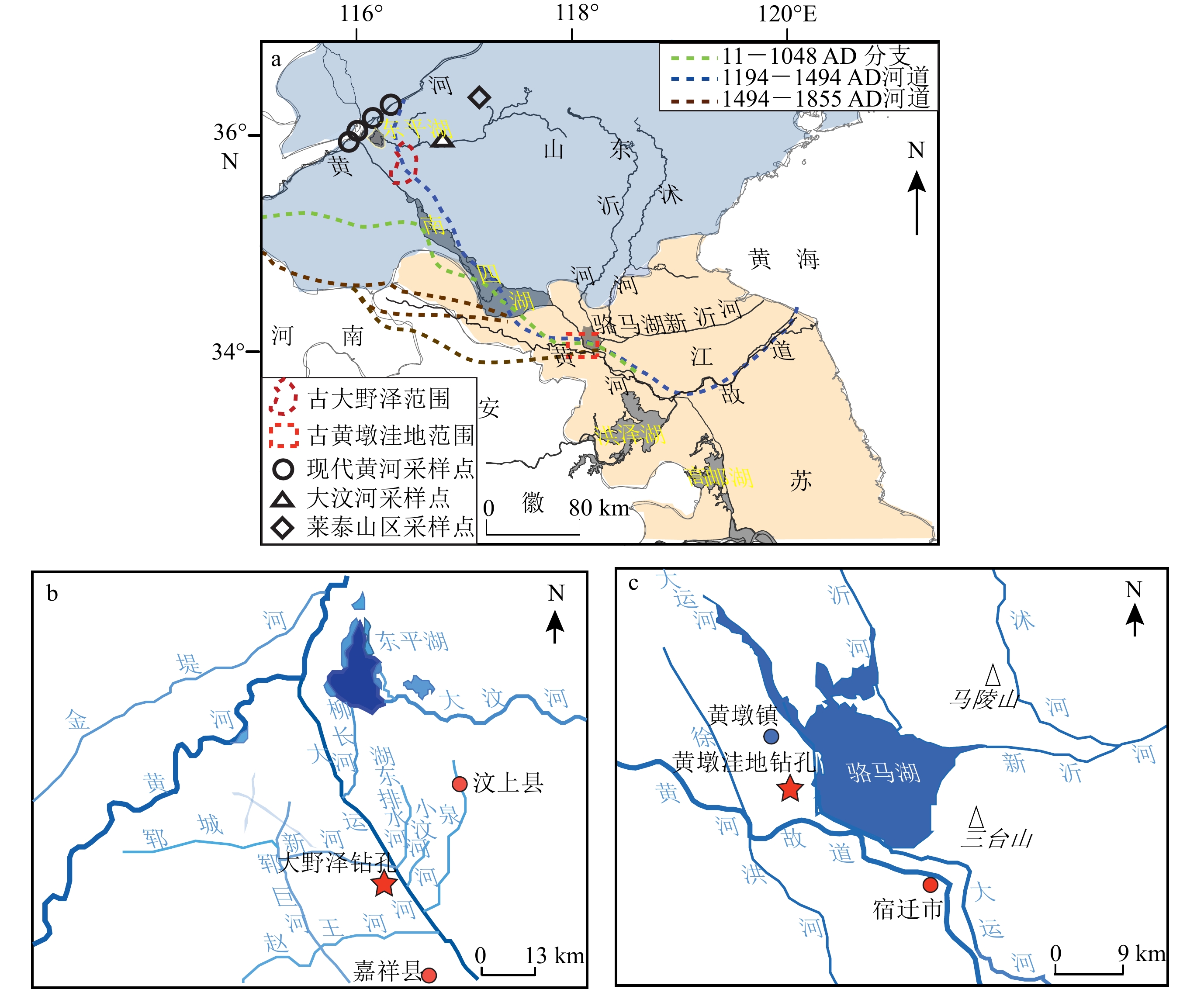
黄河下游自晚更新世以来曾先后出现过180多个湖泊、积水洼地[7],其中鲁西南地区的平原浅水型湖泊众多。随着黄河的泛滥、改道,这些湖泊不断地演化、迁移甚至消亡[46]。大野泽就是其中的典型代表 (图1a—b)。大野泽,又名巨野泽,根据《左传》记载,最早现于春秋战国时期,之后深受黄河变迁的影响[47]:公元前132年,黄河在瓠子决口,黄河水第一次侵入大野泽;公元11年黄河再次决溢、改道,河水注入大野泽,之后大野泽多次接受和失去黄河水注入,其面积不断盈缩;经受黄河多次淤积抬高之后,大野泽于公元944年北扩至梁山以北,至北宋注入大野泽的黄河洪泛日益频繁,湖面不断扩大,形成梁山泊;公元1194年黄河于阳武决口,再次侵入大野泽,但是短暂洪水注入之后发生了严重淤积,之后随着黄河南迁,湖水退却,大野泽和梁山泊于清朝中期之后消亡[47]。因此,大野泽湖盆分布区的沉积物记录了黄河北流路径上的变迁历史[9-10]。
![图 1 研究区及采样点位置]() 图 1 研究区及采样点位置Figure 1. Study area and location of sampling pointsa: The approximate locations of ancient Dayeze Lake and ancient Huangdun Depression (based on literatures[9, 49, 51], regional geological maps, and field investigations), as well as the modern sampling points in the lower reaches of the Yellow River; b: location and local environment of drilling hole in Dayeze Lake; c: location and local environment of drilling hole in Huangdun Depression.
图 1 研究区及采样点位置Figure 1. Study area and location of sampling pointsa: The approximate locations of ancient Dayeze Lake and ancient Huangdun Depression (based on literatures[9, 49, 51], regional geological maps, and field investigations), as well as the modern sampling points in the lower reaches of the Yellow River; b: location and local environment of drilling hole in Dayeze Lake; c: location and local environment of drilling hole in Huangdun Depression.苏北黄墩洼地则与黄河南迁过程密切相关(图1a、 c)。黄墩洼地地处苏北平原,属于沂沭泗河流域[48],东侧紧邻骆马湖,位于郯庐断裂带中的一组北北西向断裂切割所形成的断块上[49]。黄墩洼地作为区域集水中心,自公元前四世纪到公元11年,开始有部分黄河水道流入黄墩洼地[3,50]。公元1494年,黄河袭泗夺淮之后,由于黄墩洼地东部被马陵山阻隔,南部又有黄河夺泗河道加积,黄河、沂水等水系频繁泛滥,在洼地不断汇集、扩大,由此形成骆马湖[49]。因此,在骆马湖形成与演化的各个阶段,区域性河流洪泛物质及黄河携带的大量黄土、泥沙物质会汇聚并堆积在古黄墩洼地的地层之中。古黄墩洼地沉积物成为记录黄河河道变迁,尤其是整体南流时期,黄河下游决溢、改道的重要地质载体。
2. 材料与方法
2.1 样品采集
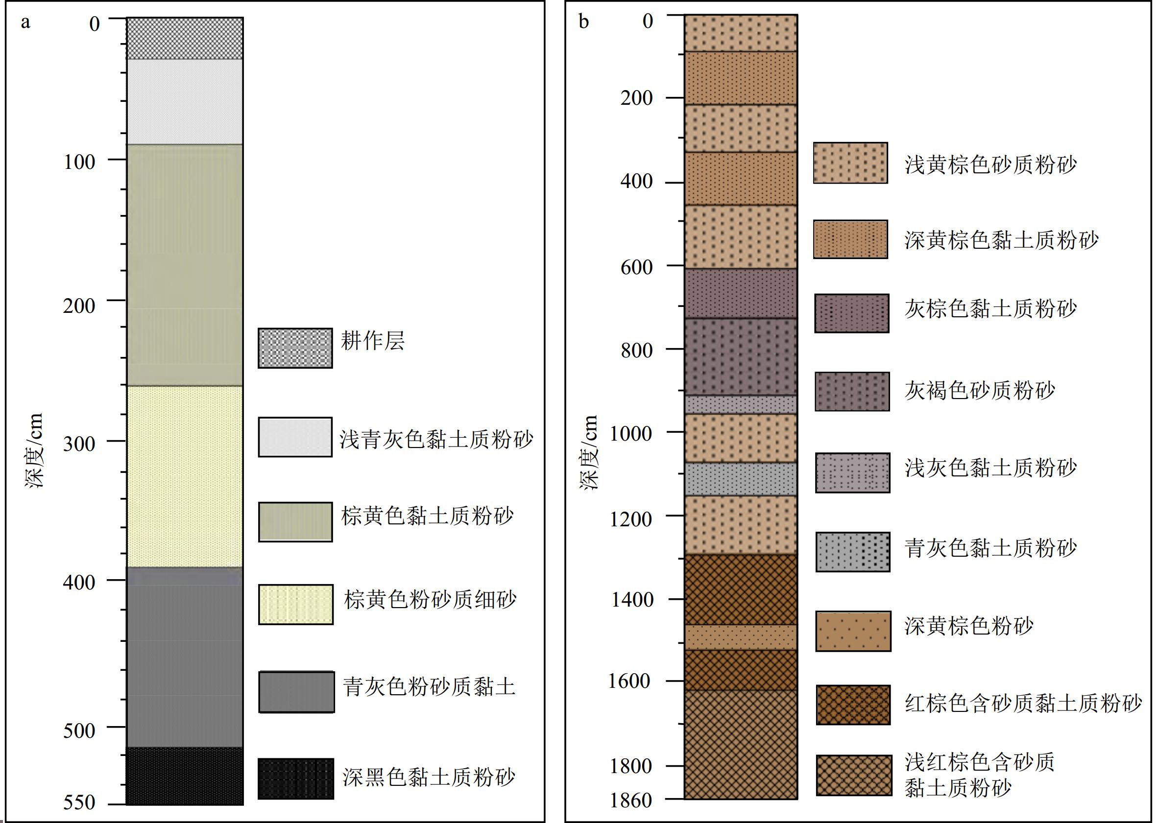
根据已有大野泽钻孔柱状岩芯(图2a)[10, 12],选取37.04 cm和51.15 cm处深受河流洪泛过程影响的样品作为大野泽洪泛层典型样品(DYZ)。选取现代黄河山东济南以西段采样点4处,获取典型黄河河漫滩样品(HH)4个。鲁西南古湖作为典型的黄河下游浅水型湖泊,除了受黄河频繁决溢、改道的影响外,还与区域性河流演化密切相关。因此,选择大野泽重要的区域性水源——古汶水(现代大汶河)采样点1处,获取现代大汶河河漫滩典型样品(DW)1个。此外,大汶河沉积物受莱泰山区碎屑物质影响较深,因此采集莱泰山区碎屑岩石样品(TS)1个。样品用于环境磁学和岩石磁学指标测试,并基于测试结果进行物源分析。
![图 2 黄河下游湖泊钻孔岩性]()
根据已有黄墩洼地钻孔柱状岩芯(ZN)(图2b)[52], 选取1个植物残体和2个有机沉积物样品进行AMS 14C测年。年代经过INTCAL20 dataset程序校正,且以两个典型黄河改道事件出现年代作为控制点进行年代检验,运用“Undatable”软件构建了年代-深度模型(黄墩钻孔具体沉积年代的构建请参考Zhang等[52])。最终界定钻孔底部年代大致为
9712 aBP。选取276个样品用于磁化率和等温剩磁等磁学指标测试,选取124个样品进行TOC和粒度指标测试。根据前期研究[52],基于沉积相、粒度及粒度端元组分等变化将ZN钻孔分为上下两个部分,分界线大致位于13 m处(相应年代为4201 aBP)。另外,选取32个黄土高原现代表土样品,进行相关磁学指标测试,用以辅助分析。基于上述样品,探讨古黄墩洼地的沉积环境演化。2.2 实验方法
2.2.1 磁学指标测量
在室温条件下,使用Bartington MS2磁化率仪在不同频率下(
4700 、470 Hz)下可以获取高频磁化率(χhf)、低频磁化率(χlf),并计算出频率磁化率(χfd=χlf– χhf )。使用ASC scientific脉冲磁力仪获得相关样品的剩磁。然后,使用AGRCO JR-6A旋转磁力仪进行剩磁测量,获得饱和等温剩磁(SIRM)和不同反向磁场等温剩磁。IRM-100 mT和IRM-300 mT分别为首先获得SIRM后,再施加100 mT和300 mT反向磁场获得的剩磁。高矫顽力组分携带的剩磁可以用HIRM来表示,表达公式为:HIRM=0.5*(SIRM+IIRM-300 mT )。非磁滞剩磁(ARM)的获取是先用Magnon International AF Demagnetizer交变退磁仪(施加的恒定弱直流场为0.05 mT,交变磁场为100 mT)获得剩磁,然后通过AGRCO JR-6A旋转磁力仪测量剩磁(精度:2×10⁻⁶ A/m)。对ARM标准归一处理后得到χARM。PMC振动样品磁力仪(MicroMag
3900 )用来测量样品磁滞回线、一阶反转曲线(FORC)及等温剩磁曲线。通过磁滞回线测量可以获取相关磁滞参数。利用非线性端元模型[35]对等温剩磁曲线进行分离,可以获取不同磁性组分信息。AGICO MFK1-FA Kappabridge 磁化率仪在通氩气的环境中可以测量磁化率随温度的变化情况,即热磁曲线(χ-T曲线)。MPMS-XL5超导量子干涉仪可以在零磁场中由300 K冷却到20 K,然后施加2.5 T磁场获得SIRM。之后,逐渐升温到300 K,获得等温剩磁随温度变化曲线,即ZFC-FC曲线。2.2.2 非磁学指标测量
利用Mastersizer 2000型激光粒度仪,在转速为
1500 转/min、80 Hz的超声频率下,对样品进行粒度测试。仪器测量范围为0.02~2 000 µm,实验误差≤0.1%。在样品进行粒度测试之前,需要对样品进行前处理。首先,将0.23~0.26 g去除杂质和植物根系的样品放入烧杯,注入10 mL双氧水溶液并加热,直至反应完全。之后,置入10 mL 盐酸溶液,继续反应,待反应结束、冷却后注满蒸馏水,静置12 h后将上层清液抽出,使烧杯中剩余20 mL溶液。最后,向烧杯中注入10 mL 的分散剂溶液进行超声波震荡,5 min后将高分散颗粒悬浮液放入激光粒度仪中进行测量。利用端元模型[53]对测试获得的粒度参数进行分离,获取不同粒级组分信息。基于Multi N/C3100型总有机碳分析仪,在0~30 000 mg/L的测试范围内获取样品总有机碳(TOC)。在测试之前需对样品进行前处理。首先,利用5~6 mL浓度为10%的HCL去除样品中的碳酸钙;之后,离心并用去离子水冲洗样品数次,直到悬浮液呈中性,冷冻干燥48 h;最后,使用玛瑙研钵研磨干燥的样品并进行测量。
3. 结果与分析
3.1 磁性矿物类型
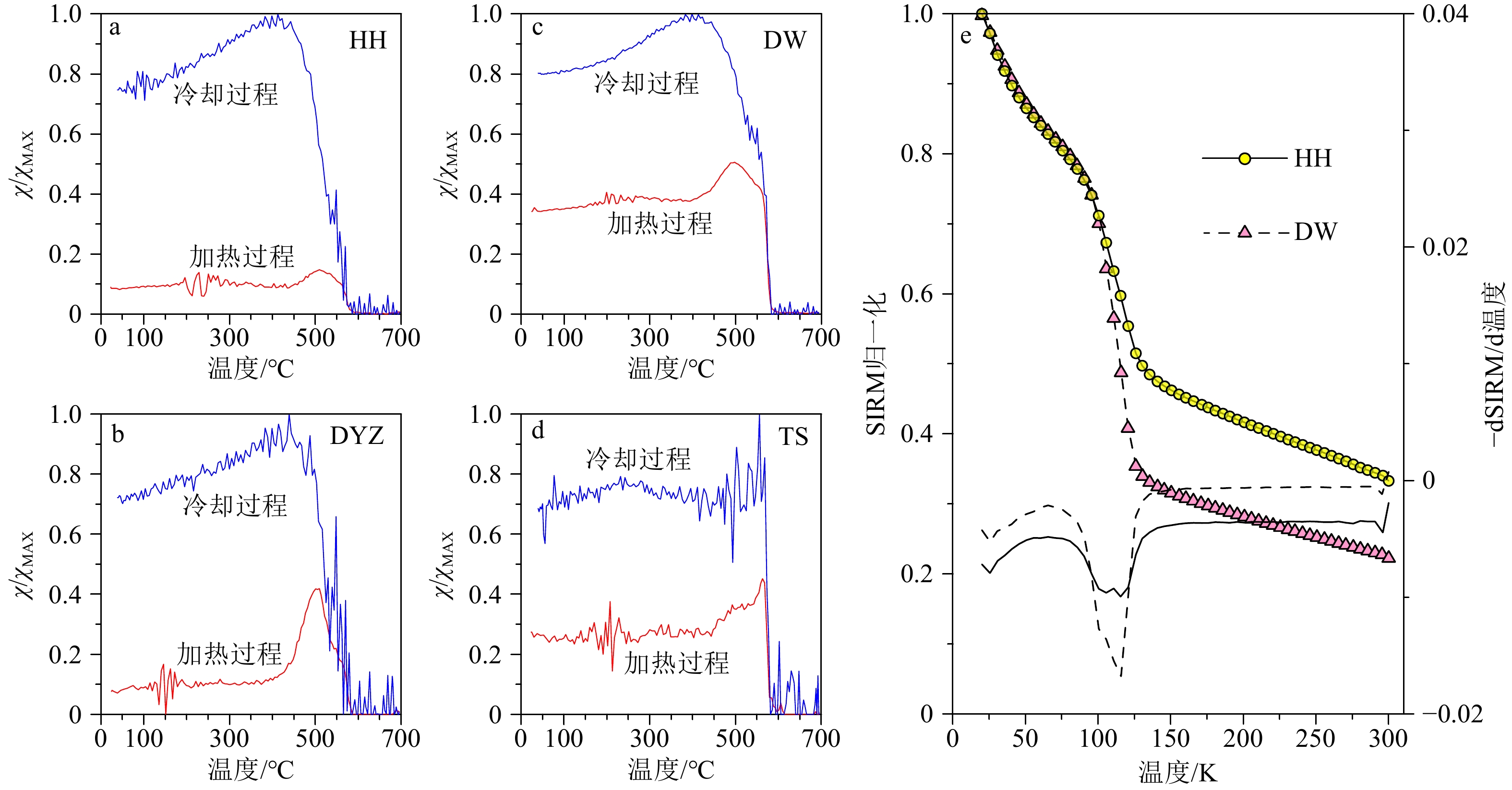
χ-T结果(图3a—d)显示HH和DYZ样品表现为相似的磁性特征,DW和TS样品表现为相似的磁性特征。HH和DYZ样品的 χ-T曲线(图3a—b)显示初始磁化率较低,说明磁性矿物受沉积后环境的改造作用影响,一些强磁性矿物被还原成磁性较弱的矿物。其加热曲线和冷却曲线之间的差值较大,说明在加热的过程中有一些新的磁性矿物生成。DW和TS样品(图3c—d)初始磁化率略高于HH和DYZ样品,指示强磁性矿物受沉积后环境的改造作用没有HH和DYZ样品明显。但是,磁性矿物冷却曲线仍高于加热曲线,反映在加热过程中也生成了相应的磁性矿物。两类样品初始磁化率的差异,体现了二者在磁性矿物组成上存在差异。此外,DW和TS样品在580℃左右磁化率存在明显的断崖式降低,对应典型磁铁矿的居里温度,指示磁铁矿的存在。HH和DYZ样品在520℃之后磁化率不断降低,在580℃左右降到最低,指示磁铁矿依然为主要的磁性矿物,但是磁铁矿在一定程度上受到沉积过程的影响和改造。
![图 3 典型样品热磁特征]() 图 3 典型样品热磁特征a-d: 磁化率随温度变化曲线(χ-T);e:低温环境中直流与交流变换系统下磁化强度变化曲线(ZFC)(黄色圆和红色三角组成的曲线,纵坐标为“SIRM 归一化”)及其一阶导数(黑色实线和虚线,纵坐标为-dSIRM/d温度)。HH为黄河样品,DYZ为大野泽洪泛沉积样品,DW为大汶河样品,TS为莱泰碎屑岩石样品。Figure 3. Thermomagnetic characteristics of typical samplesa-d: Temperature dependent curve of magnetic susceptibility (χ-T); e: magnetization intensity variation curve (ZFC) (the curves composed of yellow circles and red triangles with the vertical axis being “SIRM normalization”) and its first derivative (black solid and dashed lines with the vertical axis are “-dSIRM/dT”) under DC and AC conversion systems in low-temperature environments. HH: the Yellow River sample; DYZ: the Dayeze Lake fluvial sediments sample; DW: Dawen River sample; TS: the Laitai clastic rock sample.
图 3 典型样品热磁特征a-d: 磁化率随温度变化曲线(χ-T);e:低温环境中直流与交流变换系统下磁化强度变化曲线(ZFC)(黄色圆和红色三角组成的曲线,纵坐标为“SIRM 归一化”)及其一阶导数(黑色实线和虚线,纵坐标为-dSIRM/d温度)。HH为黄河样品,DYZ为大野泽洪泛沉积样品,DW为大汶河样品,TS为莱泰碎屑岩石样品。Figure 3. Thermomagnetic characteristics of typical samplesa-d: Temperature dependent curve of magnetic susceptibility (χ-T); e: magnetization intensity variation curve (ZFC) (the curves composed of yellow circles and red triangles with the vertical axis being “SIRM normalization”) and its first derivative (black solid and dashed lines with the vertical axis are “-dSIRM/dT”) under DC and AC conversion systems in low-temperature environments. HH: the Yellow River sample; DYZ: the Dayeze Lake fluvial sediments sample; DW: Dawen River sample; TS: the Laitai clastic rock sample.ZFC曲线揭示随着温度的增加等温剩磁逐渐降低(图3e)。当温度超过120 K时,HH和DW样品携带剩磁的能力均显著降低,但HH携带的剩磁显著高于DW。当温度继续增加到300 K,HH样品仍保持30%以上的剩磁,DW样品所携带的剩磁仅为20%左右。两个样品的ZFC一阶导数在120 K左右表现出明显的Verwey转化特征谷,指示亚铁磁性矿物磁铁矿的存在。这与χ-T曲线鉴定出的两类样品中主要的磁性矿物为磁铁矿相一致。与此同时,HH样品的Verwey转化特征谷高于DW样品,揭示在黄河沉积物中磁铁矿很可能受到沉积过程的影响和改造,磁铁矿不断发生氧化,使Verwey转化特征谷发生一定程度上的变形。ZFC曲线及其一阶导数以及χ-T结果相互一致,共同指示不同来源的沉积物其磁性矿物类型存在差异。
3.2 磁性成分和粒径大小
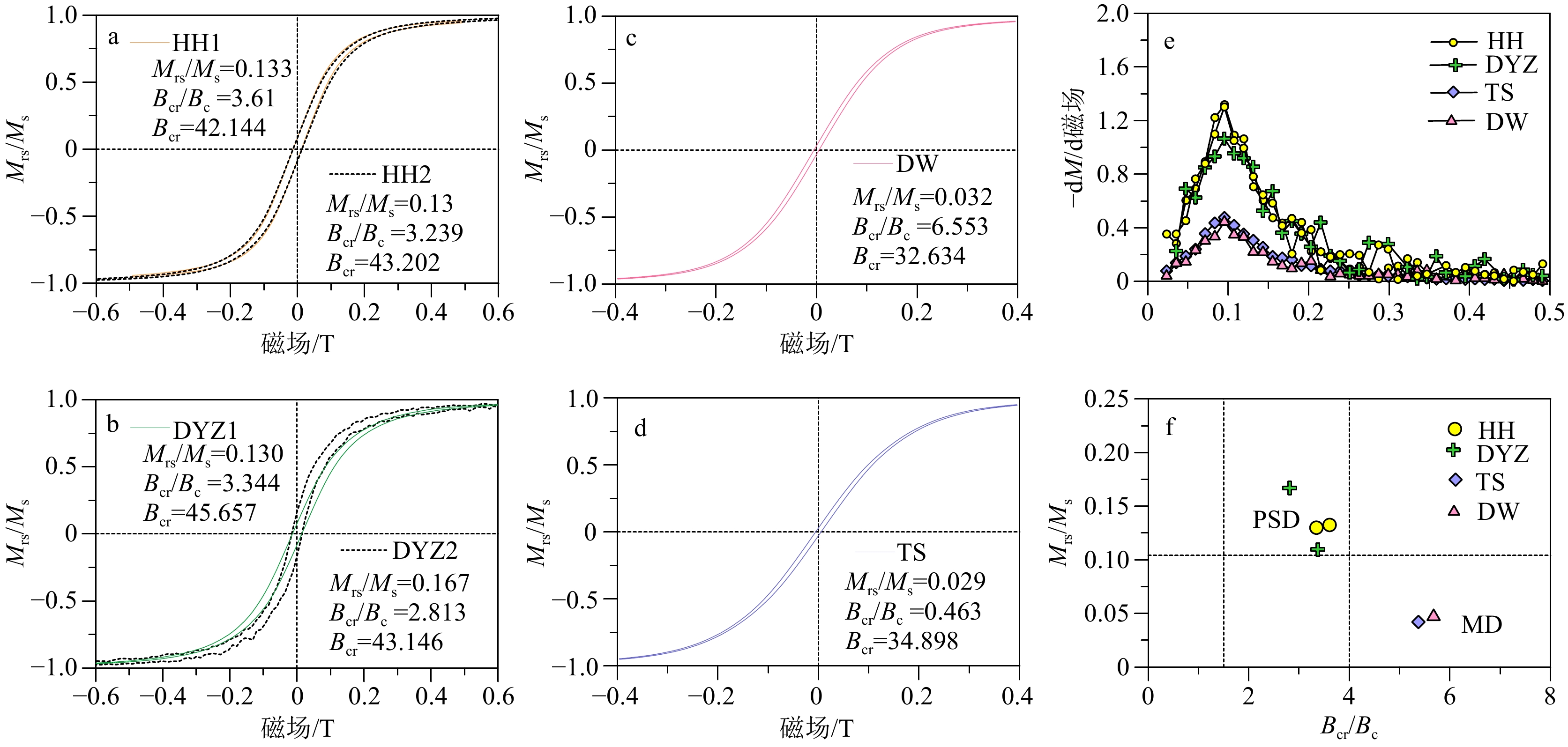
HH和DYZ样品的磁滞回线(图4a—b)表现为典型的细腰型,在0.6 T外加磁场之前没有发生闭合,指示软磁性矿物和硬磁性矿物组分共同存在。DW和TS样品的磁滞回线(图4c—d)上升和下降分支曲线更趋近于重合,并且在0.3 T外加磁场处出现完全闭合,指示磁性组分以软磁性矿物为主,高矫顽力成分贡献微小。从磁滞参数上看,HH和DYZ样品的剩磁矫顽力相似,在42~45 mT范围,DW和TS样品的剩磁矫顽力低于前者(分别为32.6和34.9 mT)。此外,磁滞回线的一阶导数结果(图4e)显示所有样品均在100 mT之前出现软磁性成分特征峰值,但是HH和DYZ样品的特征峰显著高于DW和TS样品的特征峰。在300 mT左右,HH和DYZ显示高矫顽力组分赤铁矿特征峰,而在DW和TS中没有出现此峰,说明HH和DYZ样品的赤铁矿含量显著高于DW和TS样品。
![图 4 典型样品磁滞特征]() 图 4 典型样品磁滞特征a-d:磁滞回线, e: 磁滞回线上下两条分支曲线差值相对于外加磁场一阶导数曲线(-dΔM/d磁场), f: Day 氏图。HH,DYZ,DW和TS样品同图3。Figure 4. Hysteresis characteristics of typical samplesa-d: Hysteresis loops, e: the difference between the upper and lower branch curves of the hysteresis loop and the first-order derivative curve relative to the applied magnetic field (-dΔM/d magnetic field), f:the Day Plot. HH, DYZ, DW, and TS are the same to those in Fig. 3.
图 4 典型样品磁滞特征a-d:磁滞回线, e: 磁滞回线上下两条分支曲线差值相对于外加磁场一阶导数曲线(-dΔM/d磁场), f: Day 氏图。HH,DYZ,DW和TS样品同图3。Figure 4. Hysteresis characteristics of typical samplesa-d: Hysteresis loops, e: the difference between the upper and lower branch curves of the hysteresis loop and the first-order derivative curve relative to the applied magnetic field (-dΔM/d magnetic field), f:the Day Plot. HH, DYZ, DW, and TS are the same to those in Fig. 3.从Day氏图(图4f)中可以看出,HH和DYZ样品均落在假单畴(PSD)区域,DW和TS样品落在多畴(MD)区域,说明DW和TS样品有着比HH和DYZ样品更粗的磁性颗粒。然而,由于在不同的地质沉积环境中,大小磁性颗粒常常是混合在一起的,而且磁性颗粒间的磁相互作用也会影响磁滞参数[54],进而综合表现为PSD状态。 因此,相比于Day氏图,Néel图[55](图5a)和 Lascu图[56](图5b)能够更好地展现磁性颗粒的磁畴大小以及不同磁性颗粒混合情况。Néel图显示DW和TS样品集中于MD区域,说明这两类样品磁粒径较粗。HH和DYZ样品分布较为靠近,且与MD区域存在一定距离,说明二者MD颗粒含量不及DW和TS样品。此外,HH和DYZ样品靠近单轴单畴+超顺磁(USD+SP)颗粒三角形分布区的右下角区域,指示样品受到USD和SP颗粒的混合影响但是总体影响较小。Lascu图(图5b)显示磁性颗粒间的相互作用对这些样品影响较小,但是不同粒径大小磁性颗粒的混合产生了比较大的影响。DW和TS样品更靠近典型MD颗粒区域,整体粒径大于HH和DYZ样品。相比于Néel图,Lascu图更好地揭示了HH和DYZ样品之间的差异。HH样品更靠近MD-SD混合曲线,而DYZ样品更接近MD-UNISD(单轴非相互作用单畴)混合曲线,揭示DYZ样品含有部分UNISD颗粒而HH样品中几乎没有。已有研究表明在湖泊沉积物中生物来源的磁性颗粒往往是UNISD颗粒的重要组成部分[57]。因此,Lascu图中DYZ样品与HH样品的磁性差异,主要归因于湖相沉积过程的改造作用。即便如此,HH和DYZ样品磁性颗粒组成和粒径的相似程度远远高于DW和TS样品,反映了相似的物质来源。
![图 5 典型样品的磁畴状态]() 图 5 典型样品的磁畴状态a: Néel图[55], b: Lascu图[56] 。SD:单畴, MD:多畴, SP:超顺磁颗粒, PSD:假单畴, USD:单轴单畴, CSD:稳定立方单畴, ISD:磁相互作用单畴, UNISD:单轴非相互作用单畴。HH,DYZ,DW和TS样品同图3。Figure 5. Magnetic domain states of typical samplesa: The Néel plot[55], b: the Lascu plot[56]. SD: single domain, MD: multi-domain, SP: superparamagnetic particles, PSD: pseudo-single domain, USD: uniaxial single domain, CSD: cubic single domain, ISD: interacting single domain, UNISD: uniaxial noninteracting single domain. HH, DYZ, DW, and TS are the same to those in Fig. 3.
图 5 典型样品的磁畴状态a: Néel图[55], b: Lascu图[56] 。SD:单畴, MD:多畴, SP:超顺磁颗粒, PSD:假单畴, USD:单轴单畴, CSD:稳定立方单畴, ISD:磁相互作用单畴, UNISD:单轴非相互作用单畴。HH,DYZ,DW和TS样品同图3。Figure 5. Magnetic domain states of typical samplesa: The Néel plot[55], b: the Lascu plot[56]. SD: single domain, MD: multi-domain, SP: superparamagnetic particles, PSD: pseudo-single domain, USD: uniaxial single domain, CSD: cubic single domain, ISD: interacting single domain, UNISD: uniaxial noninteracting single domain. HH, DYZ, DW, and TS are the same to those in Fig. 3.3.3 不同端元磁组分
基于BatchUnMix方法[37]获得的IRM分离结果显示HH和DYZ样品、TS和DW样品分别具有相似的磁组分(图6a—h)。HH和DYZ的组分1展现较宽的矫顽力(B1/2)分布(DP数值较大),其峰值分别集中在53.8 mT和56.8 mT,分别贡献了90.6%和86.1%左右的剩磁,成为最主要的磁组分。该组分对应被改造的碎屑磁铁矿[58],但是其B1/2略小于典型黄土中被改造的碎屑磁铁矿,这可能与河流和湖泊沉积过程的改造作用有关。此外,沉积物中磁铁矿化石也表现为相似的特征[59-60],表明HH和DYZ样品中也包含一部分生物贡献的碎屑磁铁矿。另外两个组分呈现低的剩磁贡献率(在HH中分别为3.4%和6%,在DYZ中分别为3%和10.9%),是HH和DYZ样品中的次要组分。此外,在HH和DYZ样品中组分2的B1/2数值均高于组分1,指示少量碎屑磁赤铁矿[58]的存在。但组分2在HH和DYZ样品中差异较大,反映不同沉积环境对碎屑磁赤铁矿的改造程度存在差异。组分3在HH和DYZ样品中差异较小,高的B1/2数值对应高矫顽力磁性矿物-碎屑赤铁矿[58]。
![图 6 典型样品的磁组分]() 图 6 典型样品的磁组分Figure 6. Magnetic components of typical samples
图 6 典型样品的磁组分Figure 6. Magnetic components of typical samplesDW和TS样品具有相似的低矫顽力组分(组分1),该组分对剩磁的贡献最大,为两个样品最主要的成分。其B1/2集中在40 mT左右,低于HH和DYZ组分1的B1/2。 矫顽力受磁性颗粒粒径大小的影响,通常当粒径位于PSD-MD区间内,随着颗粒变粗矫顽力不断降低[61]。根据Day氏图结果(图4f),DW和TS样品的磁性颗粒(集中在MD区域)远远大于HH和DYZ样品(集中在PSD区域)。此外,相比于HH样品,DW样品的FORC图(图6i-j)沿横轴展布的等值线中心更向左偏,沿纵轴展布的等值线开口更大,指示DW样品有着更大的磁性颗粒[31, 62]。因此,DW和TS样品组分1代表的是粗颗粒碎屑磁铁矿。DW和TS样品的组分2与被改造的碎屑磁铁矿表现为相似的特征[58],但是DW样品的B1/2略高于TS样品,说明在不同沉积环境中碎屑磁铁矿被改造的程度存在差异。此外,值得注意的是,DW和TS样品的组分3截然不同。DW样品组分3的B1/2介于其组分1和组分2之间(B1/2=50.1 mT),可能反映了生物成因硬磁组分的贡献。然而,TS样品组分3的B1/2高达
1000 mT,高于碎屑赤铁矿的矫顽力,可能反映了碎屑赤铁矿与更高矫顽力磁性矿物(如针铁矿)的混合物。3.4 相关磁性参数
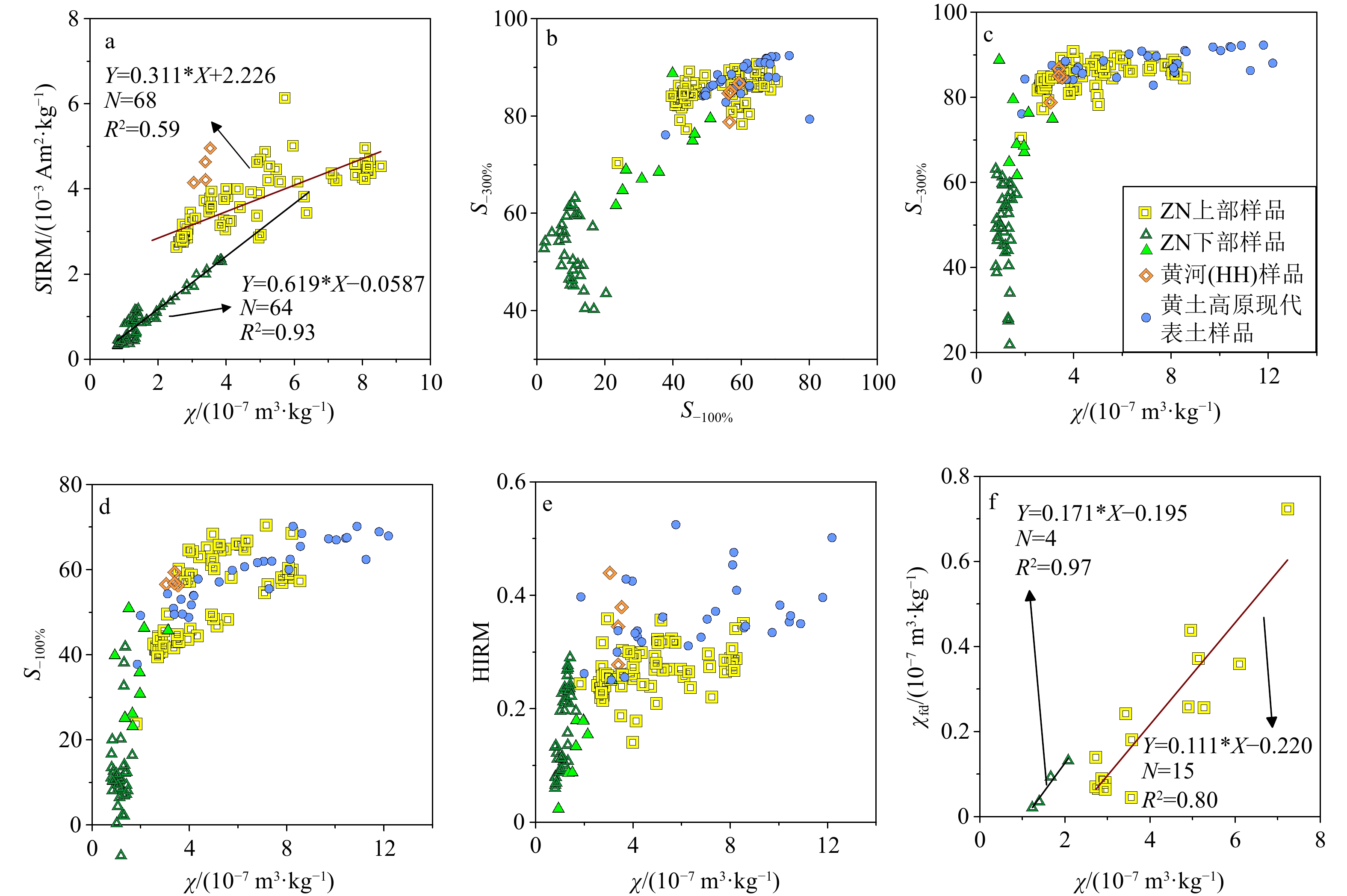
χ和SIRM是指示沉积物中磁性矿物总体浓度变化的重要指标,反映沉积物集合体整体特征[18]。其中,MD、PSD和SD级别的亚铁磁性矿物颗粒能够携带稳定剩磁,是SIRM的主要贡献者。由于SP颗粒弛豫时间快,几乎无法携带剩磁,导致SIRM不能提供沉积物中SP颗粒变化的信息。与之不同,SP颗粒具有较高的χ。此外,反铁磁性矿物赤铁矿能够携带剩磁,但是磁性较弱,其χ低于亚铁磁性矿物。因此,通过对χ和SIRM的相关性分析,能够大致判断沉积物中主要磁性颗粒的类型。图7a显示在黄墩洼地钻孔(ZN)下部样品中,其χ与SIRM具有很好的相关性(R2=0.93),说明亚铁磁性矿物为主要磁性矿物,磁性颗粒大小分布较为均匀。在ZN上部样品中,χ与SIRM均显著高于ZN下部样品,但二者相关性低于下部样品,指示磁性组成较ZN下部复杂。此外,ZN上部样品的χ和SIRM的相关性分布与典型黄河样品更为相似,指示相似的磁性颗粒组成,揭示ZN上部沉积物与黄河物质有着密切联系。
![图 7 典型样品的磁学参数相关性分析]() 图 7 典型样品的磁学参数相关性分析Figure 7. Correlation analysis of magnetic parameters of typical samples
图 7 典型样品的磁学参数相关性分析Figure 7. Correlation analysis of magnetic parameters of typical samples在各种类型沉积物中,成壤作用形成的亚铁磁性矿物,如磁铁矿,很容易被反向100 mT磁场去除掉它们的磁贡献。碎屑来源磁铁矿的矫顽力高于成壤磁铁矿,但是反向300 mT磁场也能够有效去除他们携带的剩磁信号。因此,S-100%和S-300%分别反映软磁性组分对磁性的部分和全部贡献[24]。图7b显示ZN上部样品的S-100%大多大于40%,S-300%基本在80%以上,且与典型黄河和黄土高原现代表土样品的S-100%和S-300%的相关分布相似。ZN下部样品的S-100%与S-300%呈现出两种相反的分布模式:第一种模式表现为S-100%和S-300%数值均较低且二者呈现负相关(暗绿色空心三角样品);第二种模式是S-100%和S-300%数值较高但二者呈现正相关(亮绿色实心三角样品)。这两种不同的分布模式,显示ZN下部样品包含两种不同类型的磁组分,而且ZN下部样品与黄河、黄土高原现代表土和上部样品分布区间相互分离,体现与之截然不同的沉积环境。进一步的S-300%与χ、S-100%与χ以及HIRM与χ的相关性分析(图7c—e)发现,ZN下部模式一样品的S-100%及S-300%数值均低于模式二样品,但是HIRM却略高于模式二样品,说明模式一样品属性受到高矫顽力反铁磁性矿物的深刻影响。黄河、黄土高原现代表土和ZN上部样品的χ、S-100%及S-300%数值均显著高于ZN下部样品,指示在这些样品中亚铁磁性组分为磁性主要贡献者。与此同时,较高的HIRM数值,反映这些样品比ZN下部样品富含更多的高矫顽力磁组分。此外,ZN下部典型样品的χfd与χ的相关系数高达0.97,远高于ZN上部典型样品的0.8,说明ZN下部样品中磁性矿物深受成壤作用影响,揭示了ZN上下两部分沉积物形成于不同的沉积环境。
4. 讨论
4.1 黄河下游湖泊沉积物磁性特征与物源识别
在研究的相关样品中,大野泽沉积物为典型洪泛层物质,其可能源自于黄河的决溢改道,也可能与大汶河的洪泛息息相关,而大汶河沉积物受莱泰山区基岩物质影响深刻。如果磁学指标可以区别不同来源的物质,那么大野泽样品可能与黄河样品或大汶河样品表现为相似的磁性特征,大汶河样品应与其主要源区的莱泰山区风化岩石样品具有相似的磁性特征,物源显著不同的黄河与大汶河样品的磁性特征应存在明显差异。
通过一系列岩石磁学指标测试,发现样品HH和DYZ的χ -T曲线(图3a—b)、磁滞回线(图4a—b)、Day氏图位置(4f)、Néel图位置(图5a)及IRM分离组分(图6e—f)均表现为相似的特征,说明HH与DYZ具有类似的磁性矿物类型、磁粒径大小和磁组分构成,DYZ样品受到黄河物质显著影响。样品DW与TS的磁学指标表现形式一致,说明DW与TS具有类似的磁性矿物类型、磁粒径大小和磁组分构成,DW受莱泰山区物质影响显著。
进一步对各个磁学指标分析,如:χ-T曲线显示580℃居里点(图3a—b)及–dΔM/d磁场显示约0.1 T特征峰(图4e)揭示HH和DYZ样品主要磁性矿物类型为磁铁矿;二者磁滞回线呈细长型且在0.5 T之后才逐渐闭合,且–d△M/d磁场显现约 0.3 T小峰,指示HH和DYZ样品中除了磁铁矿还存在一些高矫顽力组分;样品DW与TS的磁滞回线在0.3 T之前早已闭合(图4c—d)、–d△M/d磁场仅有约0.1 T显著高峰却无约0.3 T小峰(图4e),指示DW与TS的磁性矿物为磁铁矿。此外,HH样品的–dSIRMnorm/d温度(图3e)显示的Verwey转化特征谷高于DW,说明黄河沉积物的磁铁矿可能受到了一定程度改造。因此,受黄河显著影响的样品(HH和DYZ)与受莱泰山区物质影响的样品(DW与TS)在磁性矿物类型上存在差别。
HH和DYZ样品落在Day氏图中的PSD区域且在Néel图中偏离MD区域,而DW和TS样品则落在Day氏图的MD区域和Néel图中典型MD位置(图4f、图5a)。与此同时,相比于HH样品,DW样品的FORC图(图6i—j)沿横轴展布的等值线中心更向左偏,沿纵轴展布的等值线开口更大。此外,HH样品的ZFC曲线变化幅度小于DW(图3e)。这些结果指示DW和TS样品的磁粒径远大于HH和DYZ样品[62-63]。因此,受黄河显著影响的样品与受莱泰山区物质影响的样品在磁性颗粒大小上存在差别。
以上两类不同来源的沉积物在磁性矿物组成和磁粒径上的显著差异也可整体表现为不同的磁组分。IRM分离结果揭示HH和DYZ样品、TS和DW样品分别具有相似的磁组分(图6a—h)。HH和DYZ样品具有相似的低矫顽力和高矫顽力组分(分别反映碎屑磁铁矿和高矫顽力碎屑赤铁矿),指示黄河泥沙为大野泽洪泛层沉积物的重要物质来源。DW和TS样品存在相同的主要组分,即低矫顽力粗颗粒碎屑磁铁矿,揭示在大汶河沉积物中有很大一部分源自于莱泰山区碎屑物质。然而,DW和TS样品在另外两个组分上的差异,反映除了莱泰山区碎屑物质,可能还有其他少量物质汇入大汶河,这些物质中包含了生物成因硬磁组分,很可能对应地表径流携带的区域物质。
综合以上磁学结果,黄河和大野泽沉积物样品中主要的磁性矿物为磁铁矿(遭受一定程度改造)及少量高矫顽力矿物。与之相比,受莱泰山区物质影响的大汶河沉积物样品中磁性矿物较为单一,主要为磁铁矿且较少遭到改造,而且磁粒径远大于黄河和大野泽物质。因此,基于磁性矿物特征可以识别出大野泽典型洪泛层中主要物源为黄河泥沙。此外,基于磁性分离手段可以提供大野泽洪泛层中不同来源磁组分信息,可以定量获取洪泛层中黄河泥沙组分的变化,为进一步理清黄河下游洪泛改道事件提供可能。
4.2 黄河下游湖泊沉积物磁性矿物特征揭示的沉积环境演化
在对大野泽洪泛沉积物与黄河下游地区现代沉积物的磁性矿物研究中,证实了磁性矿物特征分析在物源识别中的有效性。与此同时,一些特征性环境磁学参数可以体现磁性矿物特征(如类型、粒径 和含量等)差异,因此可以用来探究湖泊沉积过程及沉积环境变化。此外,磁性矿物特征分析还发现大野泽洪泛沉积物虽然主要源自于黄河泥沙,但二者之间仍存在一些差异。Lascu图较好地揭示了这些差异(图5b)。在Lascu图中,HH样品更靠近MD-SD混合曲线,而DYZ样品更接近MD-UNISD混合曲线,说明DYZ样品含有部分生物作用的UNISD颗粒[57],揭示了湖相沉积过程对磁性矿物颗粒的改造作用。因此,为更好地解释黄河下游湖泊沉积物记录的信息,也需要探讨沉积过程和环境。环境磁学参数提供了沉积环境演化的重要线索。
通过对沉积序列较为完整的黄墩古洼地沉积物(ZN钻孔)研究,发现各磁性参数在不同沉积层位存在显著差异(图7)。在ZN上部样品中,χ与SIRM数值均显著高于ZN下部样品,但二者相关性低于下部样品,指示磁性组成较ZN下部复杂。此外,ZN上部样品的χ和SIRM的相关性分布与典型黄河样品更为相似,揭示ZN上部沉积物与黄河洪泛过程联系密切。进一步的S-100%与S-300%、S-100%与χ、S-300%与χ以及HIRM与χ相关性分析显示,黄河、黄土高原现代表土及ZN上部样品各磁性参数分布模式相似,富含大量的亚铁磁性组分及部分高矫顽力磁组分,且两类磁性组分含量均高于ZN下部样品。这些磁性参数揭示黄墩洼地上部沉积物受到黄河洪泛过程的影响深刻,具备黄河携带的大量黄土物质的磁性特征。然而,黄墩洼地下部沉积物与黄河物质联系不大。此外,ZN下部典型样品的χfd与χ的相关系数高达0.97,远高于ZN上部典型样品的0.8,说明ZN下部样品中磁性矿物深受成壤作用影响,进一步揭示了ZN上下两部分沉积物形成于不同的沉积环境。
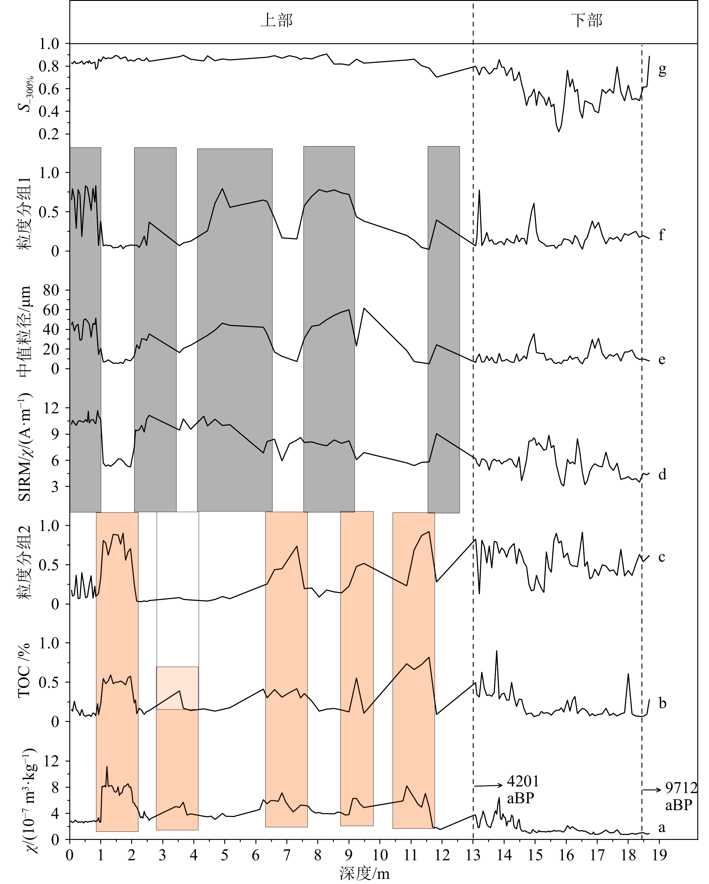
结合其他环境代用指标分析(图8),发现χ、TOC和粒度组分2[52]在上部沉积物中存在一致变化,峰值和谷值依次交替出现。峰值对应较细的沉积物粒径,谷值对应较粗的沉积物粒径,这与黄河洪泛形成的典型沉积二元结构(即砂质粉砂-黏土质粉砂互层,详见Zhang等[52])相一致。此外,基于χ与χfd较好的相关性(R2=0.8)(图7f),说明在上部沉积物中存在与成壤作用相关的细粒亚铁磁性颗粒。这些磁性颗粒可能是源区成壤磁性颗粒被黄河洪水搬运输入的,也可能是源区物质输入到黄墩洼地后经过成壤作用形成的。然而,如果黄墩洼地发生后期成壤过程,则需要黄河洪水彻底退出黄墩洼地,且洼地转化为氧化环境(即洼地干涸)。一旦洼地干涸,水生或半水生植物就会大大减少甚至死亡,此时TOC值应该会大为降低。然而黄墩洼地此阶段的TOC峰值与磁化率峰值呈现出很好的对应关系。因此,黄墩洼地这一沉积阶段不管是磁性矿物还是有机植物残体很大程度上均来自于黄河洪泛过程。根据前期研究[52],粒度组分2能够很好地表征这些物质,它们可能还包括当地的成土物质、风成物和一些区域内河流贡献的物质。在下部沉积物中,χ和TOC整体数值较低,没有出现明显的峰、谷变化,且下部沉积序列不再表现出典型的黄河洪泛沉积二元结构[52],指示黄河洪泛过程的影响微弱。不同于χ和TOC,在此阶段粒度组分2整体数值没有明显降低,反映局地细粒物质贡献增加,进一步证实此阶段几乎没有受到黄河洪泛过程的影响。
![图 8 黄墩洼地(ZN钻孔)磁性参数与其他环境代用指标变化]() 图 8 黄墩洼地(ZN钻孔)磁性参数与其他环境代用指标变化a: 磁化率(χlf), b: TOC, c: 粒度分离获得的组分2[52], d: SIRM/χlf, e: 中值粒径, f:粒度分离获得的组分1[52], g: S-300%。13 m处(左侧黑色虚线)为不同沉积环境分界线,对应4 201 aBP[52]。钻孔底部年龄(右侧黑色虚线)为9 712 aBP[52]。橙粉色和灰色分别对应河流作用下二元结构中的细颗粒和粗颗粒成分。Figure 8. Changes in magnetic parameters and other environmental indicators in the Huangdun ancient depression (ZN borehole)a: Magnetic susceptibility (χlf), b: TOC, c: component 2 obtained from grain-size unmixing[52], d: SIRM/χlf, e: median grain-size, f: component 1 obtained from grain-size unmixin[52], g: S-300%. The “13 m” (left-black dashed line) represents the boundary between different sedimentary environments, corresponding to 4 201 aBP[52]. The age at the bottom of the borehole (right-black dashed line) is 9 712 aBP[52]. The orange pink and gray areas correspond to the fine and coarse particle components in the binary structure under fluvial deposition, respectively.
图 8 黄墩洼地(ZN钻孔)磁性参数与其他环境代用指标变化a: 磁化率(χlf), b: TOC, c: 粒度分离获得的组分2[52], d: SIRM/χlf, e: 中值粒径, f:粒度分离获得的组分1[52], g: S-300%。13 m处(左侧黑色虚线)为不同沉积环境分界线,对应4 201 aBP[52]。钻孔底部年龄(右侧黑色虚线)为9 712 aBP[52]。橙粉色和灰色分别对应河流作用下二元结构中的细颗粒和粗颗粒成分。Figure 8. Changes in magnetic parameters and other environmental indicators in the Huangdun ancient depression (ZN borehole)a: Magnetic susceptibility (χlf), b: TOC, c: component 2 obtained from grain-size unmixing[52], d: SIRM/χlf, e: median grain-size, f: component 1 obtained from grain-size unmixin[52], g: S-300%. The “13 m” (left-black dashed line) represents the boundary between different sedimentary environments, corresponding to 4 201 aBP[52]. The age at the bottom of the borehole (right-black dashed line) is 9 712 aBP[52]. The orange pink and gray areas correspond to the fine and coarse particle components in the binary structure under fluvial deposition, respectively.SIRM/χ与χ、TOC和粒度组分2的变化相反,尤其是在上部沉积环境中表现明显。SIRM/χ主要用来表征磁铁矿的富集程度[64],其在上部沉积环境中与χ等参数变化相反,说明碎屑来源的磁铁矿是SIRM/χ的主要贡献者。SIRM/χ高值对应平均粒径和粒度组分1高值。根据前期研究[52],粒度组分1为黄河或当地河流贡献的粗粒碎屑物质。因此,SIRM/χ高值揭示的碎屑来源磁铁矿源自黄河或其他当地河流洪泛物质。在下部沉积物中,SIRM/χ的整体数值明显低于上部,说明不管是黄河还是当地河流贡献的碎屑磁铁矿显著降低。与此同时,下部沉积物中χ与χfd极好的相关性(R2=0.97),说明主要的磁性贡献者为成壤磁铁矿,证实下部沉积物中有更多陆源成壤物质的贡献。因此,与上部沉积环境相比,下部沉积环境几乎不再受河流洪泛过程的影响。S-300%反映亚铁磁性矿物的总体贡献,其在上部沉积物中变化稳定且数值显著高于下部,进一步揭示了两种截然不同的沉积环境。
磁性参数和其他环境指标的综合分析揭示了古黄墩洼地自
9712 aBP以来沉积环境发生了变化,从接收陆源碎屑沉积转变成河流洪泛物质沉积。沉积环境改变的节点为13 m处,即4201 aBP[52],说明黄墩地区从4201 aBP开始不断受到河流洪泛过程的影响,尤其是黄河的影响。这一时期与气候事件造成的黄河中游特大洪水出现的时间(4200 aBP)相吻合[65]。也有研究认为这一转变时期与黄河演化由主要受气候控制转变为人类活动主导的过渡时期相一致[66]。之后,在人类-环境相互作用过程中,人类活动的影响愈发显著[67]。人口增加、农业扩张、社会经济发展造成黄河频繁决溢、改道[68],自此黄墩洼地不断受到黄河下游洪泛的影响。5. 结论
(1)χ-T曲线、磁滞回线、–dΔM/d磁场曲线特征峰值、ZFC及ZFC一阶曲线揭示在大野泽洪泛沉积物和黄河物质中主要磁性矿物类型为磁铁矿(遭受一定程度改造)并伴有少量高矫顽力矿物,而大汶河物质和莱泰山区碎屑岩石主要磁性矿物为磁铁矿。Day 氏图、Néel图和FORC图结果显示大汶河物质和莱泰山区碎屑岩石的磁粒径相似,且远大于黄河物质和大野泽洪泛沉积物的磁粒径。IRM分离结果显示黄河物质和大野泽洪泛沉积物具有相似的主要磁组分,而大汶河物质和莱泰山区碎屑岩石具有相似的主要磁组分。基于磁性矿物特征可以识别出大野泽典型洪泛层中主要物源为黄河泥沙,这为在黄河下游湖泊沉积物中提取黄河决溢、改道信息提供借鉴。
(2)有关SIRM、χ、χfd、S-100%、S-300%及HIRM等参数的相关性分析显示黄河及古黄墩洼地上部样品各磁性参数分布模式相似,揭示黄墩洼地上部沉积物受到黄河洪泛过程的深刻影响。然而,黄墩洼地下部沉积物与黄河物质联系不大,但是极高的χfd与χ相关系数指示古黄墩洼地下部样品中磁性矿物深受成壤作用影响,反映了陆源碎屑沉积过程。磁学参数与粒度、TOC等指标的对比分析,进一步证实了古黄墩洼地上下两部分沉积物形成于不同的沉积环境,这两种沉积环境转变大致出现在
4201 aBP。自4201 aBP后,苏北黄墩地区不断受到黄河下游洪泛的影响。基于磁性矿物特征的环境磁学参数对揭示黄河下游湖泊演化过程及追溯黄河下游河道变迁具有重要意义。致谢:江苏师范大学于世永教授和聊城大学侯战方副教授在野外采样过程中提供指导和帮助,谨此感谢!
-
![]()
图 1 研究区及采样点位置
a: 古大野泽与古黄墩洼地大致位置(依据文献资料[9, 49, 51]、区域地质图及野外考察确定)以及黄河下游现代采样点位置,b: 大野泽钻孔位置及局域环境, c: 黄墩洼地钻孔位置及局域环境。
Figure 1. Study area and location of sampling points
a: The approximate locations of ancient Dayeze Lake and ancient Huangdun Depression (based on literatures[9, 49, 51], regional geological maps, and field investigations), as well as the modern sampling points in the lower reaches of the Yellow River; b: location and local environment of drilling hole in Dayeze Lake; c: location and local environment of drilling hole in Huangdun Depression.
![]()
![]()
图 3 典型样品热磁特征
a-d: 磁化率随温度变化曲线(χ-T);e:低温环境中直流与交流变换系统下磁化强度变化曲线(ZFC)(黄色圆和红色三角组成的曲线,纵坐标为“SIRM 归一化”)及其一阶导数(黑色实线和虚线,纵坐标为-dSIRM/d温度)。HH为黄河样品,DYZ为大野泽洪泛沉积样品,DW为大汶河样品,TS为莱泰碎屑岩石样品。
Figure 3. Thermomagnetic characteristics of typical samples
a-d: Temperature dependent curve of magnetic susceptibility (χ-T); e: magnetization intensity variation curve (ZFC) (the curves composed of yellow circles and red triangles with the vertical axis being “SIRM normalization”) and its first derivative (black solid and dashed lines with the vertical axis are “-dSIRM/dT”) under DC and AC conversion systems in low-temperature environments. HH: the Yellow River sample; DYZ: the Dayeze Lake fluvial sediments sample; DW: Dawen River sample; TS: the Laitai clastic rock sample.
![]()
图 4 典型样品磁滞特征
a-d:磁滞回线, e: 磁滞回线上下两条分支曲线差值相对于外加磁场一阶导数曲线(-dΔM/d磁场), f: Day 氏图。HH,DYZ,DW和TS样品同图3。
Figure 4. Hysteresis characteristics of typical samples
a-d: Hysteresis loops, e: the difference between the upper and lower branch curves of the hysteresis loop and the first-order derivative curve relative to the applied magnetic field (-dΔM/d magnetic field), f:the Day Plot. HH, DYZ, DW, and TS are the same to those in Fig. 3.
![]()
图 5 典型样品的磁畴状态
a: Néel图[55], b: Lascu图[56] 。SD:单畴, MD:多畴, SP:超顺磁颗粒, PSD:假单畴, USD:单轴单畴, CSD:稳定立方单畴, ISD:磁相互作用单畴, UNISD:单轴非相互作用单畴。HH,DYZ,DW和TS样品同图3。
Figure 5. Magnetic domain states of typical samples
a: The Néel plot[55], b: the Lascu plot[56]. SD: single domain, MD: multi-domain, SP: superparamagnetic particles, PSD: pseudo-single domain, USD: uniaxial single domain, CSD: cubic single domain, ISD: interacting single domain, UNISD: uniaxial noninteracting single domain. HH, DYZ, DW, and TS are the same to those in Fig. 3.
![]()
图 6 典型样品的磁组分
a-d:IRM获得曲线,e-h: 使用Batch UnMix方法[37]获得的组分模型, i-j: 一阶反转曲线(FORC)图。HH,DYZ,DW和TS与图3一致。
Figure 6. Magnetic components of typical samples
a-d: IRM acquisition curve, e-h: component model based on Batch UnMix method[37], i-j: first-order reversal curve (FORC) diagram. HH, DYZ, DW, and TS are the same to those in Fig. 3.
![]()
图 7 典型样品的磁学参数相关性分析
Figure 7. Correlation analysis of magnetic parameters of typical samples
![]()
图 8 黄墩洼地(ZN钻孔)磁性参数与其他环境代用指标变化
a: 磁化率(χlf), b: TOC, c: 粒度分离获得的组分2[52], d: SIRM/χlf, e: 中值粒径, f:粒度分离获得的组分1[52], g: S-300%。13 m处(左侧黑色虚线)为不同沉积环境分界线,对应4 201 aBP[52]。钻孔底部年龄(右侧黑色虚线)为9 712 aBP[52]。橙粉色和灰色分别对应河流作用下二元结构中的细颗粒和粗颗粒成分。
Figure 8. Changes in magnetic parameters and other environmental indicators in the Huangdun ancient depression (ZN borehole)
a: Magnetic susceptibility (χlf), b: TOC, c: component 2 obtained from grain-size unmixing[52], d: SIRM/χlf, e: median grain-size, f: component 1 obtained from grain-size unmixin[52], g: S-300%. The “13 m” (left-black dashed line) represents the boundary between different sedimentary environments, corresponding to 4 201 aBP[52]. The age at the bottom of the borehole (right-black dashed line) is 9 712 aBP[52]. The orange pink and gray areas correspond to the fine and coarse particle components in the binary structure under fluvial deposition, respectively.
-
[1] Wang Y J, Su Y J. The geo‐pattern of course shifts of the Lower Yellow River[J]. Journal of Geographical Sciences, 2011, 21(6):1019-1036. doi: 10.1007/s11442-011-0897-7
[2] Tan L C, Shen C C, Cai Y J, et al. Great flood in the middle-lower Yellow River reaches at 4000 a BP inferred from accurately-dated stalagmite records[J]. Science Bulletin, 2018, 63(4):206-208. doi: 10.1016/j.scib.2018.01.023
[3] Chen Y Z, Syvitski J P M, Gao S, et al. Socio‐economic impacts on flooding: a 4000‐year history of the Yellow River, China[J]. AMBIO, 2012, 41(7):682-698. doi: 10.1007/s13280-012-0290-5
[4] Kidder T R, Zhuang Y J. Anthropocene archaeology of the Yellow River, China, 5000-2000 BP[J]. The Holocene, 2015, 25(10):1627-1639. doi: 10.1177/0959683615594469
[5] Storozum M J, Qin Z, Ren X L, et al. The collapse of the North Song dynasty and the AD1048-1128 Yellow River floods: geoarchaeological evidence from northern Henan Province, China[J]. The Holocene, 2018, 28(11):1759-1770. doi: 10.1177/0959683618788682
[6] 张振克, 王苏民, 沈吉, 等. 黄河下游南四湖地区黄河河道变迁的湖泊沉积响应[J]. 湖泊科学, 1999, 11(3):231-236 doi: 10.18307/1999.0307 ZHANG Zhenke, WANG Sumin, SHEN Ji, et al. River channel changes recorded by lake sediments in Nansihu Lake, the lower reaches of the Yellow River[J]. Journal of Lake Sciences, 1999, 11(3):231-236.] doi: 10.18307/1999.0307
[7] 陈诗越, 侯战方, 陈影影, 等. 黄河下游地区湖泊沉积与环境[M]. 南京: 江苏凤凰科学技术出版社, 2017: 1-173 CHEN Shiyue, HOU Zhanfang, CHEN Yingying, et al. Sedimentation and Environment of Lakes in the Lower Yellow River Region[M]. Nanjing: Jiangsu Phoenix Science and Technology Press, 2017: 1-173.]
[8] 吴艳宏, 沈吉, 夏威岚, 等. 南四湖3000年来南北沉积差异[J]. 古地理学报, 1999, 1(2):78-83 doi: 10.3969/j.issn.1671-1505.1999.02.010 WU Yanhong, SHEN Ji, XIA Weilan, et al. Sedimentary difference between north and south Nansihu Lake, Shandong province[J]. Journal of Palaeogeography, 1999, 1(2):78-83.] doi: 10.3969/j.issn.1671-1505.1999.02.010
[9] 侯战方, 陈诗越, 孟静静, 等. 近1200 a来黄河下游梁山泊沉积记录的环境变迁[J]. 湖泊科学, 2018, 30(1):245-255 doi: 10.18307/2018.0124 HOU Zhanfang, CHEN Shiyue, MENG Jingjing, et al. Environmental changes in the lower reaches of Yellow River area during the last 1200 years revealed by multiple proxies from the Lake Liangshanpo[J]. Journal of Lake Sciences, 2018, 30(1):245-255.] doi: 10.18307/2018.0124
[10] 魏本杰, 侯战方, 陈诗越, 等. 黄河下游大野泽沉积物粒度特征及其对环境演化的指示[J]. 海洋地质与第四纪地质, 2019, 39(3):151-161 WEI Benjie, HOU Zhanfang, CHEN Shiyue, et al. Grain-size characteristics of Dayeze lake sediments in the lower reach of Yellow River and their environmental implications[J]. Marine Geology & Quaternary Geology, 2019, 39(3):151-161.]
[11] Chen Y Y, Chen S Y, Ma C M, et al. Palynological evidence of natural and anthropogenic impacts on aquatic environmental changes over the last 150 years in Dongping Lake, North China[J]. Quaternary International, 2014, 349:2-9. doi: 10.1016/j.quaint.2014.04.033
[12] 伏梦璇, 魏本杰, 衣雅男, 等. 黄河下游大野泽流域的侵蚀变化与气候演变[J]. 海洋湖沼通报, 2021, 43(3):8-16 FU Mengxuan, WEI Benjie, YI Yanan, et al. Erosional changes and climatic evolution of the lake Dayeze in the lower Yellow River[J]. Transactions of Oceanology and Limnology, 2021, 43(3):8-16.]
[13] Wang S, Fu B J, Piao S L, et al. Reduced sediment transport in the Yellow River due to anthropogenic changes[J]. Nature Geoscience, 2016, 9(1):38-41. doi: 10.1038/ngeo2602
[14] Zhang M, Xia J, Hong C. New challenges and opportunities for flood control in the Huai River: addressing a changing river‐lake relationship[J]. Bulletin of the Chinese Academy of Sciences, 2012, 26(1):40-47.
[15] Yu L S, Liu H B, Wan F, et al. Geochemical records of the sediments and their significance in Dongping Lake Area, the lower reach of Yellow River, North China[J]. Journal of Groundwater Science and Engineering, 2021, 9(2):140-151.
[16] Hu S Y, Deng C L, Appel E, et al. Environmental magnetic studies of lacustrine sediments[J]. Chinese Science Bulletin, 2002, 47(7):613-616. doi: 10.1360/02tb9141
[17] Thompson R, Oldfield F. Environmental Magnetism[M]. Dordrecht: Springer, 1986: 1-220.
[18] Maher B A. Palaeoclimatic records of the loess/palaeosol sequences of the Chinese Loess Plateau[J]. Quaternary Science Reviews, 2016, 154:23-84. doi: 10.1016/j.quascirev.2016.08.004
[19] Liu Q S, Roberts A P, Larrasoaña J C, et al. Environmental magnetism: principles and applications[J]. Reviews of Geophysics, 2012, 50(4):RG4002.
[20] Orgeira M J, Egli R, Compagnucci R H. A quantitative model of magnetic enhancement in loessic soils[M]//Petrovský E, Ivers D, Harinarayana T, et al. The Earth's Magnetic Interior. Dordrecht: Springer, 2011: 361-397.
[21] Liu Z F, Liu Q S, Torrent J, et al. Testing the magnetic proxy χFD/HIRM for quantifying paleoprecipitation in modern soil profiles from Shaanxi Province, China[J]. Global and Planetary Change, 2013, 110:368-378. doi: 10.1016/j.gloplacha.2013.04.013
[22] Nie J S, Song Y G, King J W, et al. Six million years of magnetic grain-size records reveal that temperature and precipitation were decoupled on the Chinese Loess Plateau during~ 4.5-2.6 Ma[J]. Quaternary Research, 2013, 79(3):465-470. doi: 10.1016/j.yqres.2013.01.002
[23] Hatfield R G, Stoner J S, Reilly B T, et al. Grain size dependent magnetic discrimination of Iceland and South Greenland terrestrial sediments in the northern North Atlantic sediment record[J]. Earth and Planetary Science Letters, 2017, 474:474-489. doi: 10.1016/j.jpgl.2017.06.042
[24] Liu Q S, Roberts A P, Torrent J, et al. What do the HIRM and S-ratio really measure in environmental magnetism?[J]. Geochemistry, Geophysics, Geosystems, 2007, 8(9):Q09011.
[25] Roberts A P, Zhao X, Heslop D, et al. Hematite (α-Fe2O3) quantification in sedimentary magnetism: limitations of existing proxies and ways forward[J]. Geoscience Letters, 2020, 7(1):8. doi: 10.1186/s40562-020-00157-5
[26] Carter‐Stiglitz B, Moskowitz B, Solheid P, et al. Low‐temperature magnetic behavior of multidomain titanomagnetites: TM0, TM16, and TM35[J]. Journal of Geophysical Research: Solid Earth, 2006, 111(B12):B12S05.
[27] Chang L, Heslop D, Roberts A P, et al. Discrimination of biogenic and detrital magnetite through a double Verwey transition temperature[J]. Journal of Geophysical Research: Solid Earth, 2016, 121(1):3-14. doi: 10.1002/2015JB012485
[28] Egli R. Analysis of the field dependence of remanent magnetization curves[J]. Journal of Geophysical Research: Solid Earth, 2003, 108(B2):2081.
[29] Jackson M, Solheid P. On the quantitative analysis and evaluation of magnetic hysteresis data[J]. Geochemistry, Geophysics, Geosystems, 2010, 11(4):Q04Z15.
[30] Dunlop D J. Theory and application of the Day plot (M rs/M s versus H cr/H c) 1. Theoretical curves and tests using titanomagnetite data[J]. Journal of Geophysical Research: Solid Earth, 2002, 107(B3):2056.
[31] 秦华峰, 刘青松, 潘永信. 一阶反转曲线(FORC)图的原理及应用实例[J]. 地球物理学报, 2008, 51(3):743-751 doi: 10.3321/j.issn:0001-5733.2008.03.015 QIN Huafeng, LIU Qingsong, PAN Yongxin. The first-order reversal curve (FORC) diagram: theory and case study[J]. Chinese Journal of Geophysics, 2008, 51(3):743-751.] doi: 10.3321/j.issn:0001-5733.2008.03.015
[32] Roberts A P, Heslop D, Zhao X, et al. Understanding fine magnetic particle systems through use of first-order reversal curve diagrams[J]. Reviews of Geophysics, 2014, 52(4):557-602. doi: 10.1002/2014RG000462
[33] Ilse S E, Groß F, Schütz G, et al. Understanding the interaction of soft and hard magnetic components in NdFeB with first-order reversal curves[J]. Physical Review B, 2021, 103(2):024425. doi: 10.1103/PhysRevB.103.024425
[34] Heslop D, Roberts A P. A method for unmixing magnetic hysteresis loops[J]. Journal of Geophysical Research: Solid Earth, 2012, 117(B3):B03103.
[35] Heslop D. Numerical strategies for magnetic mineral unmixing[J]. Earth-Science Reviews, 2015, 150:256-284. doi: 10.1016/j.earscirev.2015.07.007
[36] Maxbauer D P, Feinberg J M, Fox D L. MAX UnMix: a web application for unmixing magnetic coercivity distributions[J]. Computers & Geosciences, 2016, 95:140-145.
[37] 白帆, 常燎, 薛鹏飞, 等. 等温剩磁曲线分解方法及其批量处理工具BatchUnMix[J]. 地球物理学报, 2022, 65(12):4789-4801 doi: 10.6038/cjg2022Q0232 BAI Fan, CHANG Liao, XUE Pengfei, et al. Decomposing isothermal remanent curves and development of a batch processing tool BatchUnMix[J]. Chinese Journal of Geophysics, 2022, 65(12):4789-4801.] doi: 10.6038/cjg2022Q0232
[38] Harrison R J, Muraszko J, Heslop D, et al. An improved algorithm for unmixing first-order reversal curve diagrams using principal component analysis[J]. Geochemistry, Geophysics, Geosystems, 2018, 19(5):1595-1610. doi: 10.1029/2018GC007511
[39] Roberts A P, Heslop D, Zhao X, et al. Unlocking information about fine magnetic particle assemblages from first-order reversal curve diagrams: recent advances[J]. Earth-Science Reviews, 2022, 227:103950. doi: 10.1016/j.earscirev.2022.103950
[40] Zhang R, Necula C, Heslop D, et al. Unmixing hysteresis loops of the late Miocene-early Pleistocene loess-red clay sequence[J]. Scientific Reports, 2016, 6(1):29515. doi: 10.1038/srep29515
[41] Bellon U D, Trindade R I F, Williams W. Unmixing of magnetic hysteresis loops through a modified gamma‐Cauchy exponential model[J]. Geochemistry, Geophysics, Geosystems, 2023, 24(8):e2023GC011048. doi: 10.1029/2023GC011048
[42] Wu D, Zhou A F, Chen X M, et al. Hydrological and ecosystem response to abrupt changes in the Indian monsoon during the last glacial, as recorded by sediments from Xingyun Lake, Yunnan, China[J]. Palaeogeography, Palaeoclimatology, Palaeoecology, 2015, 421:15-23. doi: 10.1016/j.palaeo.2015.01.005
[43] Lisé-Pronovost A, St-Onge G, Gogorza C, et al. Rock-magnetic proxies of wind intensity and dust since 51, 200 cal BP from lacustrine sediments of Laguna Potrok Aike, southeastern Patagonia[J]. Earth and Planetary Science Letters, 2015, 411:72-86. doi: 10.1016/j.jpgl.2014.11.007
[44] Zhong W, Wei Z Q, Shang S T, et al. A 15, 400-year record of environmental magnetic variations in sub-alpine lake sediments from the western Nanling Mountains in South China: implications for palaeoenvironmental changes[J]. Journal of Asian Earth Sciences, 2018, 154:82-92. doi: 10.1016/j.jseaes.2017.12.005
[45] Fu H, Li M K, Bao K S, et al. Environment change recorded by lake sediment magnetism in the Songnen Plain, northeastern China[J]. Science of the Total Environment, 2024, 919:170938. doi: 10.1016/j.scitotenv.2024.170938
[46] 张汉洁. 黄河下游山东段古湖泽的变迁[J]. 人民黄河, 1987(5):67-69 ZHANG Hanjie. Process of lakes along the lower Yellow River in ancient time[J]. Yellow River, 1987(5):67-69.]
[47] 喻宗仁, 窦素珍, 赵培才, 等. 山东东平湖的变迁与黄河改道的关系[J]. 古地理学报, 2004, 6(4):469-479 doi: 10.3969/j.issn.1671-1505.2004.04.009 YU Zongren, DOU Suzhen, ZHAO Peicai, et al. Relationship between changes of Dongping Lake and shifting of the Yellow River in Shandong Province[J]. Journal of Palaeogeography, 2004, 6(4):469-479.] doi: 10.3969/j.issn.1671-1505.2004.04.009
[48] 吕鸿燕, 祁德丽, 蒋雯, 等. 基于4G物联网卡的黄墩湖滞洪区远程视频监控系统应用探讨[J]. 治淮, 2019(3):28-29 doi: 10.3969/j.issn.1001-9243.2019.03.016 LV Hongyan, QI Deli, JIANG Wen, et al. Discussion on the application of remote video monitoring system in Huangdun Lake flood detention area based on 4G IoT Card[J]. Harnessing the Huaihe River, 2019(3):28-29.] doi: 10.3969/j.issn.1001-9243.2019.03.016
[49] 杨迈里, 王云飞. 骆马湖的成因与演变[J]. 湖泊科学, 1989, 1(1):37-44 doi: 10.18307/1989.0105 YANG Maili, WANG Yunfei. The origin and evolution of Luoma Lake[J]. Scientia Limnologica Sinica, 1989, 1(1):37-44.] doi: 10.18307/1989.0105
[50] Xue C T. Historical changes in the Yellow River delta, China[J]. Marine Geology, 1993, 113(3-4):321-330. doi: 10.1016/0025-3227(93)90025-Q
[51] 江苏省地方志编纂委员会. 江苏江河湖泊志[M]. 南京: 江苏凤凰教育出版社, 2019 Jiangsu Provincial Local Chronicles Compilation Committee. Records of Rivers and Lakes in Jiangsu[M]. Nanjing: Jiangsu Phoenix Education Publishing House, 2019.]
[52] Zhang R, Xing L, Yu S Y, et al. Holocene overflow events of the lower Yellow River recorded in Huangdun ancient lake, northern Jiangsu Plain, China[J]. Journal of Quaternary Science, 2024, 39(3):443-456. doi: 10.1002/jqs.3599
[53] Yu S Y, Colman S M, Li L X. BEMMA: a hierarchical Bayesian end-member modeling analysis of sediment grain-size distributions[J]. Mathematical Geosciences, 2016, 48(6):723-741. doi: 10.1007/s11004-015-9611-0
[54] Roberts A P, Hu P X, Harrison R J, et al. Domain state diagnosis in rock magnetism: evaluation of potential alternatives to the day diagram[J]. Journal of Geophysical Research: Solid Earth, 2019, 124(6):5286-5314. doi: 10.1029/2018JB017049
[55] Tauxe L, Bertram H N, Seberino C. Physical interpretation of hysteresis loops: micromagnetic modeling of fine particle magnetite[J]. Geochemistry, Geophysics, Geosystems, 2002, 3(10):1055.
[56] Lascu I, Banerjee S K, Berquó T S. Quantifying the concentration of ferrimagnetic particles in sediments using rock magnetic methods[J]. Geochemistry, Geophysics, Geosystems, 2010, 11(8):Q08Z19.
[57] Egli R, Chen A P, Winklhofer M, et al. Detection of noninteracting single domain particles using first‐order reversal curve diagrams[J]. Geochemistry, Geophysics, Geosystems, 2010, 11(1):Q01Z11.
[58] Spassov S, Heller F, Kretzschmar R, et al. Detrital and pedogenic magnetic mineral phases in the loess/palaeosol sequence at Lingtai (Central Chinese Loess Plateau)[J]. Physics of the Earth and Planetary Interiors, 2003, 140(4):255-275. doi: 10.1016/j.pepi.2003.09.003
[59] Egli R. Characterization of individual rock magnetic components by analysis of remanence curves, 1. Unmixing natural sediments[J]. Studia Geophysica et Geodaetica, 2004, 48(2):391-446. doi: 10.1023/B:SGEG.0000020839.45304.6d
[60] Xue P F, Chang L, Pei Z W, et al. Discovery of giant magnetofossils within and outside of the Palaeocene-Eocene Thermal Maximum in the North Atlantic[J]. Earth and Planetary Science Letters, 2022, 584:117417. doi: 10.1016/j.jpgl.2022.117417
[61] Hartstra R L. Grain-size dependence of initial susceptibility and saturation magnetization -related parameters of four natural magnetites in the PSD-MD range[J]. Geophysical Journal International, 1982, 71(2):477-495. doi: 10.1111/j.1365-246X.1982.tb05998.x
[62] Franco V, Dodrill B. Magnetic Measurement Techniques for Materials Characterization[M]. Cham: Springer, 2021: 1-805.
[63] Smirnov A V. Low-temperature magnetic properties of magnetite using first-order reversal curve analysis: implications for the pseudo-single-domain state[J]. Geochemistry, Geophysics, Geosystems, 2006, 7(11):Q11011.
[64] Peters C, Dekkers M J. Selected room temperature magnetic parameters as a function of mineralogy, concentration and grain size[J]. Physics and Chemistry of the Earth, Parts A/B/C, 2003, 28(16-19):659-667. doi: 10.1016/S1474-7065(03)00120-7
[65] Huang C C, Pang J L, Zha X C, et al. Extraordinary floods related to the climatic event at 4200 a BP on the Qishuihe River, middle reaches of the Yellow River, China[J]. Quaternary Science Reviews, 2011, 30(3-4):460-468. doi: 10.1016/j.quascirev.2010.12.007
[66] Yu S Y, Li W J, Zhou L, et al. Human disturbances dominated the unprecedentedly high frequency of Yellow River flood over the last millennium[J]. Science Advances, 2023, 9(8):eadf8576. doi: 10.1126/sciadv.adf8576
[67] Xie L Y, Daudjee Z, Liu C F, et al. Settlement relocation, urban construction, and social transformation in China's central plain, 2300-1500 B. C[J]. Asian Perspectives, 2020, 59(2):299-329. doi: 10.1353/asi.2020.0016
[68] Chen Y Z. Flood dynamics of the lower Yellow River over the last 3000 years: characteristics and implications for geoarchaeology[J]. Quaternary International, 2019, 521:147-157. doi: 10.1016/j.quaint.2019.05.040
 下载:
下载: