Sediment grain size characteristics of the Core SH-CL38 in the Shenhu area on the northern continental slope of the South China Sea
-
摘要: 南海北部陆坡神狐海域发育众多海底峡谷,其物质来源、地貌形态、水动力条件、沉积过程复杂,海底滑坡和浊流频发。虽然通过地球物理(多波束和反射地震等)能够识别出数米至百米的滑坡体,但对于浅层海底重力流、浊流和异重流等沉积体系的高分辨率识别还受到很多限制。本研究以南海北部陆坡海底峡谷群12号峡谷脊部下游的SH-CL38站位岩芯沉积物为研究对象,通过粒度测试和浮游有孔虫氧同位素组成分析,将该站位岩芯划分为3个层段:第Ⅰ层段(0~285 cm)、第Ⅱ层段(285~615 cm)以及第Ⅲ层段(615~800 cm)。其中第Ⅱ层段的粒度参数、有孔虫的氧同位素组成明显不同于其他层段,这表明该层段形成时的水动力条件、沉积环境发生了突变。而且第II层段的285~505 cm和505~615 cm具有明显不同的概率累积曲线特征,粒度数据也分布在C-M图上不同的区域。基于此,我们认为该站位的异常沉积层是受深水沉积作用和末次冰期海平面变化的影响,285~505 cm层段发育浊流沉积,而505~615 cm层段可能是浊流或重力流引发的沉积物失稳。Abstract: A number of submarine canyons has been found in the Shenhu area on the northern continental slope of the South China Sea. Sediment sources, topographic features, hydrodynamic conditions, and depositional processes in these canyons are very complex, owing to the occurrence of submarine landslides and related turbidity currents. Landslides are found, by means of geophysical surveys, such as multi-beam bathymetric survey and high-resolution multi-channel seismic profiles, varying in scale from several to hundred meters. However, the high-resolution identification of the depositional systems, such as gravity flow, turbidity current, and hyperpycnal current on the shallow seafloor remains difficult. In this study, we analyzed the columnar sediments taken from the sampling station of SH-CL38 which is located in the lower reaches of the canyon on the northern slope of the South China Sea. According to the grain size distribution patterns of sediments and the oxygen isotope composition of foraminifera, the core sediments of SH-CL38 can be subdivided into the three units: Unit Ⅰ (0~285 cm), Unit Ⅱ (285~615 cm) and the Unit Ⅲ (615~800 cm). The physical and geochemical features of the Unit II, including grain size and the oxygen isotope composition of foraminifera are obviously different from those of the other two units. This suggests that the hydrodynamic conditions and depositional environment have been sharply changed while the Unit II was deposited. The grain size distribution patterns and the probability cumulative curves at 285~505 cm and 505~615 cm in depth are completely different and located in different areas of the C-M diagram. Based on the data mentioned above, it is concluded that the sediments of SH-CL38 is deposited in a deep-water environment under the influence of sea level change. The sediments of 285~505 cm is related to the turbidity current, while the 505~615 cm is formed in an instable environment under the influence of turbidity current or gravity flow.
-
晚第四纪深海沉积物通常被认为可以提供较为准确且连续的沉积记录,从而更好地重建大陆和海洋沉积环境的耦合演化[1]。南海北部陆坡沉积环境复杂,重力流和浊流广泛发育,是陆源碎屑沉积物进入深海平原的主要路径,已成为研究深水沉积的热点地区之一[2-3]。尤其是珠江口外海底峡谷的东北侧600~1600 m的水深范围,发育着多条呈NNW-SSE向分布的线状海底负地形[4]。然而目前已有的研究大多是地球物理资料,尤其是多波束及2D或3D地震剖面,大尺度上研究中晚更新世发育的深水水道[5]或海底峡谷的沉积物失稳[6],直接针对海底峡谷群沉积物的微观地球化学研究相对较少,导致其搬运方式仍然存在很大的争议[7]。
海洋沉积物一般记录着古环境、古海洋、古地貌和古气候的演化。沉积物的粒度分布是沉积物的基本特征之一,与沉积环境密切相关[8]。尤其是海底峡谷区沉积物的粒度参数及其组合特征,记录了沉积物的搬运方式、水动力条件和沉积环境的演变[9]。例如许莎莎等[10]对南海西北部陆坡ZK3岩芯沉积物的AMS14C定年、粒度及地球化学元素分析,结合萨哈-兰迪姆相浊流环境判别及C-M图识别出4个特征明显的浊积层,其中有3次是发生在末次冰期。章伟艳等[11]以南海东部3个站位的岩芯沉积物为研究对象,根据粒度参数、概率累积曲线和有孔虫的碳氧同位素组成等综合分析,识别出多次浊流沉积事件,年龄均为晚更新世中晚期,全新世未见发育。赵玉龙等[12]通过粒度参数和XRF元素扫描及电子探针测试对南海南部MD05-2895站位末次冰期的深海沉积物进行分析,共发现5处浊流沉积层且均具有向上变细的正粒序特征。周杨锐等[13]通过对南海北部A和B两个岩芯沉积物进行粒度分析,认为A岩芯沉积物出现地层倒转现象与沉积物失稳和滑塌所引起的浊流沉积有关。
南海北部陆坡区流系十分复杂,不同沉积动力之间相互影响、相互触发[14-15]。研究表明,南海北部陆坡区神狐海域海底峡谷群的沉积物经常发生失稳,甚至有的已经发生滑塌[16]。通过地震反射剖面和数值模拟的差异性,研究者在大范围和宏观上对神狐海域海底峡谷群的深水沉积作用和沉积相进行了详细的类型划分和特征描述,认为广泛发育重力流及浊流沉积[17]。通过2D/3D地震资料,Su等[18]认为南海北部陆坡沉积物主要是以重力流搬运方式为主。Chen等[19]利用高密度的地震资料建立海底峡谷群的沉积模式,不仅识别出深水沉积体系,而且还分析了沉积物供给和沉积物失稳对峡谷群的不同影响。这些研究多集中在神狐海域的含水合物层或峡谷的上游区,这些区域大多含甲烷水合物,具有典型的沉积物特征[20]、沉积速率[21]、生物指标[22]、沉积相[23]和地震反射特征[3],对峡谷区下部沉积物的研究较少,具体的沉积特征、水动力条件和制约因素仍不清楚。
本文以神狐海域海底峡谷群12号峡谷脊部下游的SH-CL38站位岩芯沉积物为研究对象,根据沉积物岩性特征、粒度参数及有孔虫的氧同位素组成并结合AMS14C年龄进行综合分析,发现该区存在两处异常沉积层,它们具有不同的沉积特征、水动力条件和影响因素,为深水沉积体系下研究沉积物的微观变化、水动力改变和环境演化研究提供依据。
1. 区域概况
南海是西太平洋最重要的边缘海之一,位于欧亚板块、太平洋板块和印度洋板块的交汇处,面积约为350×104 km2,平均水深约1350 m[24]。南海北部陆坡为被动型大陆边缘,水深为500~3500 m,属于深水沉积环境[25]。大陆架平坦开阔,陆坡地形较为复杂,底流十分活跃,发育大量峡谷水道、海底滑坡、泥底辟和海底断层等地貌[26]。
神狐海域位于南海北部陆坡中段神狐暗沙的东南海域附近,即西沙海槽与东沙群岛之间,构造上属于珠江口盆地珠Ⅱ凹陷的白云凹陷[27](图1A)。中中新世以来,受河流输入和陆坡地形的影响,白云凹陷发生侧向迁移和垂向叠加从而发育大量深水水道、海底峡谷和沉积物失稳等,呈现类型多样、相互叠置、成因复杂的深水沉积特征[28-29]。该区域发育有17条海底峡谷群(图1B),垂直于陆坡并呈NNW-SEE向线状分布,区内水深约500~1500 m,是深水沉积物搬运的重要通道和陆源碎屑物质的重要沉积场所。此外,海底峡谷也是浊流和滑塌的频发区域[30-31]。
2. 材料和方法
SH-CL38站位位于南海北部陆坡神狐海域,珠江口外海底峡谷群12号峡谷的脊部下游(图1B),于2018年7月由广州海洋地质调查局HYSH201805航次通过重力取样获得。SH-CL38站位水深为1288 m,岩芯长约800 cm。沉积物取到甲板上之后,按照0.5 m间距进行切割,将首尾密封好后立即封存在4 ℃冰箱中。我们以2 cm等间距分样,密封冷冻保存,等待分析。
2.1 粒度分析
对岩芯沉积物以10 cm为间隔进行取样,先选取67个样品进行粒度测试,后对异常沉积层进行加密,每两个样品间隔为2 cm,增加了22个样品。因此,本研究共对89个样品进行了粒度测试分析。
粒度分析的前处理步骤如下:首先取0.5~1 g样品放入离心管底部,加入15 mL浓度为15%的H2O2去除有机质杂质,充分震荡摇匀后静置24 h;待反应完全后,加入5 mL浓度为10%的HCl去除钙质生物,微晃动离心管使样品和HCl混合均匀,再静置12 h;待沉积物中的钙质充分反应后,加入MiliQ水,并反复离心直至离心管中的剩余沉积物呈中性。粒度测试在自然资源部国家海洋局第一海洋研究所完成。仪器为英国Malvern公司产Mastersizer2000激光粒度分析仪,粒径范围为0.02~2 000 μm,测试的相对误差<2%。
2.2 有孔虫的氧同位素组成
为获得分辨率较高的氧同位素数据,我们对沉积物共进行两次取样。第一次取样是以20 cm为间隔,挑选38个沉积物样品,第二次取样以1 m为间隔,挑选8个加密样品,共计46个沉积物样品。测试时,首先按照微体古生物分析方法对有孔虫进行挑选和处理:用超纯水浸泡24 h使沉积物充分分散后,将沉积物放在240目(孔径为63 μm)标准铜筛上,用去离子水冲洗并震荡以完全除去泥质沉积物,分离出粒径超过63 μm的粗组分。然后将粗组分在常温下晾干,在显微镜下挑选20~30枚壳体完整、无黑点、无泥质充填的浮游有孔虫(G.ruber)用于氧同位素测试。上机前,先将挑选好的有孔虫移至玻璃小管中,在显微镜下将壳体压为2~3瓣,同时抛弃大块填充物。这些碎的壳体首先用浓度为10%的双氧水浸泡30 min;移出废液,再加入浓度为99.9%的无水乙醇,用40 kHz的超声波清洗1 min;最后用去离子水冲洗至中性。将清洗后的样品用60 ℃的烘箱干燥 5 h,再转移到Gasbench质谱联用装置中测定碳氧同位素比值。该测试是在青岛海洋科学与技术试点国家实验室完成,测试仪器为Thermo Fisher公司的Delta V稳定同位素比质谱仪。仪器分析精度为0.05‰,样品池温度为72 ℃,反应时间为1 h,标准参照中国国家碳酸钙标准(GBW04405)和国际标准 (NBS19)。
2.3 AMS14C定年
本研究共挑选12个沉积物样品进行AMS14C测年。在浸泡、过筛、冲洗烘干后,在显微镜下挑选完整、未污染的单种浮游有孔虫(G.ruber),每个样品至少10 mg。样品制备方法与有孔虫氧同位素组成测试的前处理方法相同。然后送往青岛海洋科学与技术试点国家实验室测试。测试仪器为National Electrostatics Corporation (NEC, Middleton, Wisconsin, USA)加速器质谱仪,测试条件为0.5MV Pelletron。
3. 结果
3.1 岩性和粒度参数特征
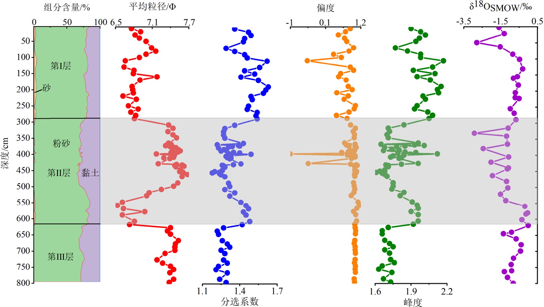
SH-CL38站位的岩芯沉积物主要由粉砂和黏土组成(图2)。其中粉砂组分的平均含量为74%;545 cm层位的含量为83%;455 cm层位的含量为67%。黏土组分的平均含量为24%,455 cm层位的含量为33%;545 cm层位的含量为15%。砂组分含量较少,平均含量仅为2%。
SH-CL38站位岩芯沉积物在垂向上岩性和粒度参数呈不均一变化(图2)。根据粒度参数的变化将该岩芯划分为3个层段:第Ⅰ层段(0~285 cm)砂组分平均含量为2.71%,平均粒径为6.62~7.18Φ,分选系数为1.29~1.63,分选较差,偏度为−0.47~1.03,峰度为1.77~2.17。第Ⅱ层段(285~615 cm)沉积物的砂含量减少,颗粒表现为粗-细-粗的变化过程。粒度参数波动频率较大,平均粒径为6.53~7.68Φ,分选系数为1.18~1.49,分选较差,偏度为−1.00~1.16,峰度为1.61~2.12。第Ⅲ层段(615~800 cm)不含砂组分,粉砂的平均含量为73%,黏土的平均含量为27%,各粒度参数变化较小,平均粒径为7.18~7.53Φ,分选系数为1.21~1.32,偏度为0.99~1.04,峰度为1.63~1.76。
3.2 有孔虫的氧同位素组成
SH-CL38站位有孔虫的氧同位素组成为−2.66‰~0.27‰(图2)。岩芯第Ⅱ层段(285~615 cm)的氧同位素组成变化较大,在331 cm处为最低值(−2.66‰),619 cm处为最高值(0.27‰)。
3.3 AMS14C定年
根据AMS14C定年结果(表1)、浮游有孔虫的氧同位素组成(图2)并参照LR04站位氧同位素组成[35]构建SH-CL38站位的年代框架。首先岩芯0~102 cm划分为氧同位素1期,有孔虫的δ18O值变化为−0.20‰~−2.53‰,代表着MIS1温暖的沉积环境。130~132 cm层段的年龄为26348 cal.aBP,155~157 cm层段的年龄为37368 cal.aBP,平均沉积速率为2.27 cm/ka,因次将137 cm层位作为氧同位素2期和3期的界线。不过该岩芯MIS2层段的沉积物记录较少,MIS3又未见底,因此,SH-CL38站位岩芯沉积物记录的是50 kaBP以来的全新世沉积和晚更新世沉积。
表 1 SH-CL38站位的AMS14C定年结果Table 1. AMS14C dating results of SH-CL38 station深度/cm 测试材料 测年结果/aBP 2σ范围/cal.aBP 校正年龄/cal.aBP 0~2 G.ruber 2070±25 1617~1802 1710 48~50 G.ruber 6555±40 7013~7239 7126 100~102 G.ruber 12745±45 14159~14784 14472 130~132 G.ruber 22470±120 26028~26668 26348 155~157 G.ruber 33500±190 36608~38127 37368 255~257 G.ruber >43500 >43500 >43500 365~367 G.ruber 42410±390 >43500 >43500 405~407 G.ruber 34280±230 37733~38946 38340 462~464 G.ruber >43500 >43500 >43500 521~523 G.ruber >43500 >43500 >43500 645~647 G.ruber >43500 >43500 >43500 798~800 G.ruber >43500 >43500 >43500 值得注意的是,出现255~257和365~567 cm层位年龄数据均超过43500 cal.aBP、而405~407 cm层位的年龄变年轻仅为38340 cal.aBP的现象。462~464 cm以下的地层年龄均大于43500 cal.aBP,超过AMS14C的准确定年范围(表1),其余年龄利用Calib 6.01软件中的Marine09数据库将14C年龄校正为日历年龄。
4. 讨论
4.1 SH-CL38站位的沉积特征
沉积物的粒度参数记录了物质搬运、沉积、再悬浮以及再沉积的水动力特点,能够反演沉积环境中的水动力条件和搬运方式[36-37]。其中粒度参数的偏度和峰度能敏感地反映粒度粗细端元的变化,对区分不同搬运动力和沉积环境有重要意义[38]。
SH-CL38站位岩芯沉积物的平均粒径为6.53~7.68Φ,与神狐海域GMGS01区的4个站位平均粒径分布范围(6.2~7.9Φ)相似[28]。SH-CL38站位岩芯第Ⅰ层段(0~285 cm)砂组分的平均含量为2.71%,平均粒径为6.62~7.18Φ,分选较差,有孔虫的δ18O值为−2.53‰~−0.04‰,表明该层段属于水动力较强的半深海沉积环境。虽然255~257 cm层段的年龄大于43500 cal.aBP,但该层段的粒度参数和岩性组成并没有明显变化。但在285 cm层位以后,沉积物的粒度明显变细,分选系数和峰度值也变小,有孔虫的δ18O值出现降低并波动变化(图2),表明岩芯在285 cm层位沉积环境发生了变化。岩芯第Ⅱ层段(285~615 cm)存在两段明显不同的粒度参数特征,据此分为285~505和505~615 cm两个层段进行研究。其中285~505 cm层段的沉积物颗粒较细,仅在361~371、383~399和407~425 cm等层位出现少量砂组分,粒度参数波动频率大并出现峰值(图2)。其中395 cm的平均粒径为7.17Φ,459 cm的平均粒径为7.68Φ,平均粒径的变化呈现粒度向上变细的正粒序特征;沉积物的偏度在该层段的395和425 cm处出现负值;分选系数(1.27—1.49—1.18)和峰度(1.65—2.12—1.61)也呈现先增大后减小的韵律变化,并均于395 cm层位达最大值。505~615 cm层段的平均粒径为7.05~6.53Φ,该层段平均粒径变小,即颗粒较285~505 cm层段变粗;分选系数为1.32~1.48,分选变差;偏度变化较小;峰度为1.81~1.96。浮游有孔虫的δ18O值在505~615 cm层段为−0.95‰~0.24‰,而在上部285~505 cm层段可达到−2.66‰~−0.80‰,出现一定的负异常现象,这比南海其他站位氧同位素变化幅度更大[39-40]。岩芯第Ⅲ层段(615~800 cm)的沉积物全部由粉砂和黏土组成,平均粒径为7.18~7.53Φ,偏度、峰度变化均较小(图2),有孔虫的δ18O值为−1.08‰~0.27‰,指示了水动力较弱的深海沉积环境。
浊流和海底滑塌都是海洋中常见的重力流活动,常表现为沉积物粒度的突然变化,因此,沉积物的粒度参数被认为是识别浊流和海底滑塌最可靠的标志[15]。李军等[41]对冲绳海槽A23孔的研究认为,沉积物粒度参数和粒度组成的突然变化代表了浊流沉积,通常具有粒径变粗、分选变差、偏度出现负值及砂含量增加等特征,这与SH-CL38站位岩芯第Ⅱ层段异常沉积层的粒度参数变化相似。然而,岩芯第II层段的粒度分布并没有呈现出浊流沉积典型的鲍马序列特征。章伟艳等[11]指出并不是所有的浊流沉积层都能记录完整的鲍马序列。Shanmugam[42]对世界各海区长达6000多米的岩芯进行了观察和描述,认为浊流沉积的判别标志为颗粒向上变细的正粒序及沉积物底部发育冲刷构造。SH-CL38站位岩芯第Ⅱ层段发育两段粒度参数明显不同的层段,其中385~395和459~555 cm层段沉积物的平均粒径指示了向上变细的正粒序,285~505 cm层段的偏度出现两次负值,分选系数和峰度呈现一定的韵律变化。浮游有孔虫的δ18O值呈一定的负偏(图2),加之,SH-CL38站位沉积物AMS14C年龄在岩芯第II层段还出现新老倒转现象,这些证据均表明岩芯第II层段受到了事件沉积的影响,发育非正常沉积层。zhao等[12]发现南海南部MD05-2895站位末次冰期的浊流沉积层也出现类似的粒度特征。
4.2 异常沉积层的判别及成因机制
海底峡谷沉积物的搬运方式和沉积过程一直是深水沉积体系研究的关键[43]。南海北部陆坡神狐海域海底峡谷群的地质构造及水动力条件复杂,是研究深水沉积的理想地区[44]。研究表明,神狐海域峡谷群的11-17号海底峡谷沉积物搬运的主要动力是由构造作用控制的重力流沉积,如滑动、滑塌、碎屑流及浊流等[40]。
4.2.1 异常沉积层的判别
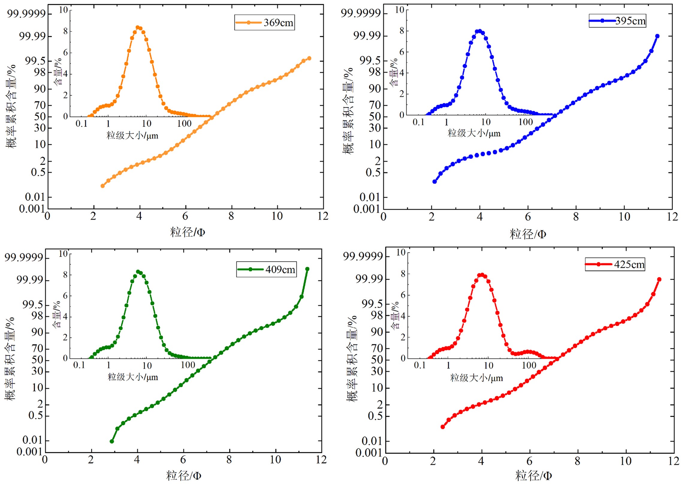
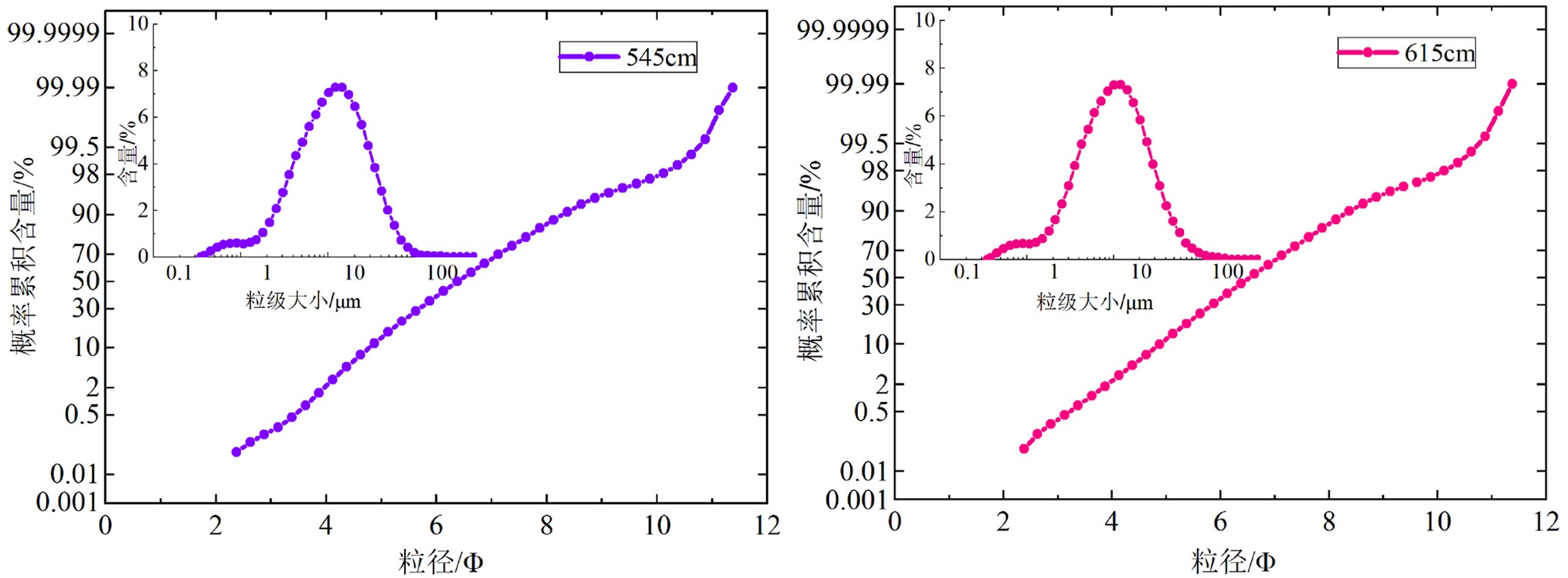
除岩性和粒度参数外,粒度的概率累积曲线可以反映沉积环境水动力的搬运方式。当粒度频率曲线为正态分布时,概率累积曲线应为一条直线。具有不同粒级组分时,概率累积曲线则表现为不同斜率相互叠加的直线段,斜率越大说明分选性越好,代表着推移、跃移和悬浮三种不同的搬运方式[45-46]。SH-CL38站位的粒度频率曲线多以单峰的正态分布为主,第Ⅰ层段多数峰宽且平缓,第Ⅱ层段有粒度分布较为集中的高峰,也出现宽缓的单峰,第Ⅲ层段分选较好,为粒度分布较为集中且众数小于10 μm的单峰。可见岩芯第Ⅰ层段和第Ⅲ层段的沉积环境较为稳定,第II层段沉积环境较为复杂。下文将重点讨论岩芯第II层段(285~615 m)异常沉积层的沉积环境。由于第II层段存在两段明显不同的粒度参数特征,因此将第II层段分为两部分进行分析。
(1)285~505 cm层段
岩芯285~505 cm层段的粒度频率曲线为粒度集中分布的单峰(图3),众数小于10 μm。概率累积曲线表现为斜率较缓的一段式和两段式分布,分选较差,表明沉积物是以悬浮组分为主。其中395 cm层位的概率累积曲线为悬浮组分大于85%的一段式;369、409和425 cm层位的概率累积曲线表明沉积物的悬浮组分大于90%,分选较差,悬浮总体对应的粒度区间较宽,主要粒径为4~9Φ。
(2)505~615 cm层段
岩芯505~615 cm层段的粒度频率曲线呈宽缓的单峰分布(图4),众数大于10 μm,颗粒较285~505 cm层段变粗。概率累积曲线呈以悬浮组分为主的两段式分布,悬浮组分大于90%,主要粒径为3~9Φ,呈现受重力流影响快速堆积的特征。
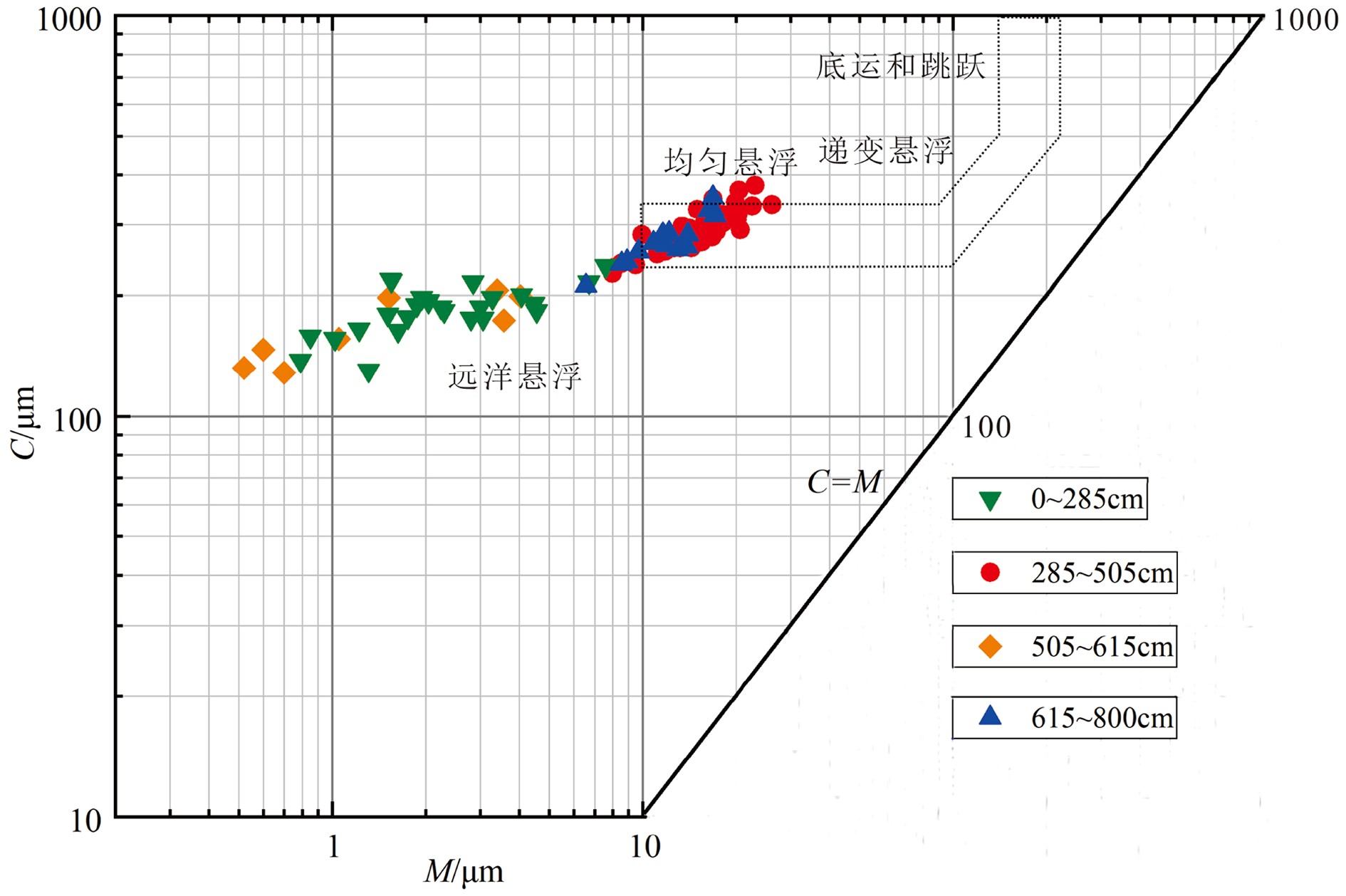
粒度C-M图是研究沉积环境的理想指标之一,其中C值是概率累积曲线上1%对应的粒径,M值是50%处对应的粒径[47]。浊流及重力流是携带物质发生的快速搬运沉积,沉积物几乎都是以悬浮的搬运方式为主,因此浊流沉积的样品点一般在粒度C-M图上落在悬浮区,与C=M基线平行并呈线性排列,不同于牵引流沉积的三段式[48-49]。在粒度C-M图上,285~505 cm层段的粒度M值为8~25,C值为200~400,C与M成比例增加,表现为近平行于C=M基线的递变悬浮方式(图5),为浊流沉积的典型特征,其他3个层段的样品点均分散分布并主要位于深海静水远洋悬浮区域。结合岩芯粒度参数变化及该站位位于峡谷脊部下游的深水环境,判断岩芯285~505 cm层段发育浊流沉积,505~615 cm层段推测可能受重力流影响较大,但该层段的总体砂含量均较少,可能是由于浊流或重力流的幅度较小,仅影响了小范围的沉积物。后续研究中我们会对异常层段的沉积物和正常层段沉积物的物源信息进行对比,以期解决这个问题。
4.2.2 异常沉积层的成因探讨
南海北部陆坡神狐海域海底峡谷的沉积物除受海平面变化、河流输入等影响较大外,风尘、海底底流及重力流活动也有重大贡献[7]。研究站位位于峡谷脊部下游的深水环境,其中风尘输入对沉积物的影响较稳定,而沉积物被底流持续改造一般会表现出牵引流的沉积特征,分选较好,且具有向上突变的接触关系[50]。因此,风尘和底流不足以引起SH-CL38站位岩芯第II层段粒度参数及有孔虫δ18O值的异常变化。
(1)深水沉积作用
深海沉积作用类型多样,沉积过程复杂[51]。南海北部峡谷内的深水沉积主要为重力流、等深流和内波作用[52]。重力流一般具有间断性和爆发性,常伴随大量碎屑物质的快速堆积。等深流作用主要通过黑潮南海分支和中层环流水对沉积物进行侵蚀搬运,而内波作用则是对底部沉积物进行持续改造[40]。海洋沉积中,海底峡谷内重力流和浊流频发,浊流是最常见的重力流活动之一,多发育在陆架斜坡和深海盆地[53]。王一凡等[15]认为珠江的河流会穿过南海北部陆架输送大量陆源物质搬运至海底峡谷,常引起边坡失稳甚至造成沉积物滑塌,使峡谷内成为浊流易发区。SH-CL38站位岩芯沉积物的颗粒较细,以黏土质粉砂为主,而岩芯第II层段505~615 cm与发育浊流沉积的285~505 cm层段粒度参数明显不同,颗粒明显变粗,分选变差,以悬浮组分为主,推测可能是受重力流的影响发生了沉积物失稳。该站位岩芯沉积物在海底峡谷内不仅受南海中层与深层环流水的共同作用,还被重力流或浊流等深水沉积作用在很大程度上进行分选改造,影响着沉积物的再搬运和再沉积过程。
(2)海平面的变化
末次冰期以来,全球海平面的变化十分活跃(图6),发生了多次海平面快速变化的事件,海平面最低可达到−130 m左右,直到全新世才逐渐趋于稳定[54]。SH-CL38站位位于神狐海域海底峡谷群12号峡谷脊部的下游,岩芯第II层段异常沉积层(285~615 m)属于末次冰期,全新世发育正常沉积。异常沉积层具有两段明显不同的粒度参数变化,本研究通过岩性、粒度参数及有孔虫的δ18O值变化的综合分析,认为285~505 cm层段发育浊流沉积,而505~615 cm层段推测是受重力流影响发生的沉积物失稳,为沉积物再搬运和再沉积的产物。因此,我们推断该站位的异常沉积层与海平面变化密切相关。海平面在末次冰期持续降低,大量陆源物质被搬运到南海北部陆坡沉积,同时海底峡谷较陡的地形也为浊流沉积提供了有利条件。海平面变化时期,沉积事件之间常相互影响,相互作用,海底峡谷内频繁发生重力流或浊流活动,浊流搬运进一步引起沉积物失稳[55-56]。地球物理资料表明在海底峡谷下游沉积物经常发生失稳造成滑塌,从而引发浊流[45]。不过,海平面波动可能并不是直接因素,引发浊流通常是一些阵发性事件,如坍塌、海啸、火山及地震等[57]。因此,结合SH-CL38站位末次冰期的沉积特征和对异常沉积层影响因素的综合研究,我们认为该站位发育的异常沉积受深水沉积作用和海平面变化的影响较大,其中285~505 cm层段发育浊流沉积,而505~615 cm层段可能是浊流或重力流引发的沉积物失稳。
5. 结论
(1)SH-CL38站位发育约50 ka以来的沉积,沉积物为黏土质粉砂,颗粒较细。根据岩性组成、粒度参数和有孔虫氧同位素组成变化将该岩芯划分为3个层段,其中第Ⅰ层段(0~285 cm)为水动力较强的半深海沉积环境;第Ⅱ层段(285~615 cm)具有两段明显不同的粒度参数特征,浮游有孔虫δ18O值出现负偏,AMS14C年龄也出现新老倒转现象,表明该层段沉积环境复杂,发育异常沉积层;第Ⅲ层段(615~800 cm)为水动力较弱的深海沉积环境。
(2)该站位岩芯第Ⅱ层段(285~615 cm)的异常沉积层根据粒度参数和有孔虫δ18O值的变化分为285~505和505~615 cm两个层段,结合概率累积曲线和粒度C-M图进一步分析其沉积环境,认为285~505 cm层段发育浊流沉积,而505~615 cm层段推测可能是重力流引发的沉积物失稳。
(3)通过对海底峡谷脊部下游SH-CL38站位的微观地球化学分析,认为在海底峡谷的复杂深水环境中,该站位岩芯第Ⅱ层段发育的异常沉积层不仅受到深水沉积作用的分选改造,而且还与末次冰期海平面的变化密切相关。
-
表 1 SH-CL38站位的AMS14C定年结果
Table 1 AMS14C dating results of SH-CL38 station
深度/cm 测试材料 测年结果/aBP 2σ范围/cal.aBP 校正年龄/cal.aBP 0~2 G.ruber 2070±25 1617~1802 1710 48~50 G.ruber 6555±40 7013~7239 7126 100~102 G.ruber 12745±45 14159~14784 14472 130~132 G.ruber 22470±120 26028~26668 26348 155~157 G.ruber 33500±190 36608~38127 37368 255~257 G.ruber >43500 >43500 >43500 365~367 G.ruber 42410±390 >43500 >43500 405~407 G.ruber 34280±230 37733~38946 38340 462~464 G.ruber >43500 >43500 >43500 521~523 G.ruber >43500 >43500 >43500 645~647 G.ruber >43500 >43500 >43500 798~800 G.ruber >43500 >43500 >43500 -
[1] 龚跃华, 张光学, 郭依群, 等. 南海北部神狐西南海域天然气水合物成矿远景[J]. 海洋地质与第四纪地质, 2013, 33(2):97-104 GONG Yuehua, ZHANG Guangxue, GUO Yiqun, et al. Prospect of gas hydrate resources in the area to southwest Shen-Hu of northern South China Sea [J]. Marine Geology & Quaternary Geology, 2013, 33(2): 97-104.
[2] 郭依群, 杨胜雄, 梁金强, 等. 南海北部神狐海域高饱和度天然气水合物分布特征[J]. 地学前缘, 2017, 24(4):24-31 GUO Yiqun, YANG Shengxiong, LIANG Jinqiang, et al. Characteristics of high gas hydrate distribution in the Shenhu area on the northern slope of the South China Sea [J]. Earth Science Frontiers, 2017, 24(4): 24-31.
[3] He Y, Zhong G F, Wang L L, et al. Characteristics and occurrence of submarine canyon-associated landslides in the middle of the northern continental slope, South China Sea [J]. Marine and Petroleum Geology, 2014, 57: 546-560. doi: 10.1016/j.marpetgeo.2014.07.003
[4] 刘杰, 孙美静, 杨睿, 等. 泥底辟输导流体机制及其与天然气水合物成藏的关系[J]. 现代地质, 2016, 30(6):1399-1407 doi: 10.3969/j.issn.1000-8527.2016.06.022 LIU Jie, SUN Meijing, YANG Rui, et al. Diapir conduit fluid mechanism and its relationship with gas hydrate accumulations [J]. Geoscience, 2016, 30(6): 1399-1407. doi: 10.3969/j.issn.1000-8527.2016.06.022
[5] Zhu M Z, Graham S, Pang X, et al. Characteristics of migrating submarine canyons from the middle Miocene to present: implications for paleoceanographic circulation, northern South China Sea [J]. Marine and Petroleum Geology, 2010, 27(1): 307-319. doi: 10.1016/j.marpetgeo.2009.05.005
[6] 王珊珊, 王永波, 扶卿华, 等. 珠江口水体组分的吸收特性分析[J]. 环境科学, 2014, 35(12):4511-4521 WANG Shanshan, WANG Yongbo, FU Qinghua, et al. Spectral absorption properties of the water constituents in the estuary of Zhujiang River [J]. Environmental Science, 2014, 35(12): 4511-4521.
[7] 袁圣强, 吴时国, 赵宗举, 等. 南海北部陆坡深水区沉积物输送模式探讨[J]. 海洋地质与第四纪地质, 2010, 30(4):39-48 YUAN Shengqiang, WU Shiguo, ZHAO Zongju, et al. Deepwater sediment transportation models for northern South China Sea slopes [J]. Marine Geology & Quaternary Geology, 2010, 30(4): 39-48.
[8] Doeglas D J. Grain-size indices, classification and environment [J]. Sedimentology, 1968, 10(2): 83-100. doi: 10.1111/j.1365-3091.1968.tb01101.x
[9] Xie X N, Müller R D, Ren J Y, et al. Stratigraphic architecture and evolution of the continental slope system in offshore Hainan, northern South China Sea [J]. Marine Geology, 2008, 247(3-4): 129-144. doi: 10.1016/j.margeo.2007.08.005
[10] 许莎莎, 冯秀丽, 冯利, 等. 南海西北部莺琼陆坡36.6ka以来的浊流沉积[J]. 海洋地质与第四纪地质, 2020, 40(5):15-24 XU Shasha, FENG Xiuli, FENG Li, et al. Turbidite records since 36.6ka at the Yingqiong continental slope in the northwest of South China Sea [J]. Marine Geology & Quaternary Geology, 2020, 40(5): 15-24.
[11] 章伟艳, 张富元, 张霄宇, 等. 南海东部海域柱样沉积物浊流沉积探讨[J]. 热带海洋学报, 2003, 22(3):36-43 doi: 10.3969/j.issn.1009-5470.2003.03.006 ZHANG Weiyan, ZHANG Fuyuan, ZHANG Xiaoyu, et al. Characteristics of turbidity deposits from sediment cores in eastern South China Sea [J]. Journal of Tropical Oceanography, 2003, 22(3): 36-43. doi: 10.3969/j.issn.1009-5470.2003.03.006
[12] Zhao Y L, Liu Z F, Colin C, et al. Turbidite deposition in the southern South China Sea during the last glacial: Evidence from grain-size and major elements records [J]. Chinese Science Bulletin, 2011, 56(33): 3558-3565. doi: 10.1007/s11434-011-4685-7
[13] 周杨锐, 朱友生, 周松望, 等. 南海北部东沙隆起西侧陆坡坡折处浊流沉积[J]. 海洋科学, 2018, 42(2):23-33 doi: 10.11759/hykx20171101003 ZHOU Yangrui, ZHU Yousheng, ZHOU Songwang, et al. Turbidites at the continental slope on the west side of Dongsha uplift in the northern South China Sea [J]. Marine Sciences, 2018, 42(2): 23-33. doi: 10.11759/hykx20171101003
[14] 邵磊, 李学杰, 耿建华, 等. 南海北部深水底流沉积作用[J]. 中国科学 D辑: 地球科学, 2007, 50(7):1060-1066 doi: 10.1007/s11430-007-0015-y SHAO Lei, LI Xuejie, GENG Jianhua, et al. Deep water bottom current deposition in the northern South China Sea [J]. Science in China Series D: Earth Sciences, 2007, 50(7): 1060-1066. doi: 10.1007/s11430-007-0015-y
[15] 王一凡, 苏正, 苏明, 等. 南海北部陆坡神狐海域沉积物失稳类型探讨[J]. 海洋地质与第四纪地质, 2017, 37(5):184-194 WANG Yifan, SU Zheng, SU Ming, et al. Sediment failures in the Shenhu area, northern continental slope of the south China Sea [J]. Marine Geology & Quaternary Geology, 2017, 37(5): 184-194.
[16] Chen D X, Wang X J, Völker D, et al. Three dimensional seismic studies of deep-water hazard-related features on the northern slope of South China Sea [J]. Marine and Petroleum Geology, 2016, 77: 1125-1139. doi: 10.1016/j.marpetgeo.2016.08.012
[17] Felix M. Flow structure of turbidity currents [J]. Sedimentology, 2002, 49(3): 397-419. doi: 10.1046/j.1365-3091.2002.00449.x
[18] Su M, Yang R, Wang H B, et al. Gas hydrates distribution in the Shenhu Area, northern South China Sea: comparisons between the eight drilling sites with gashydrate petroleum system [J]. Geologica Acta, 2016, 14(2): 79-100.
[19] Chen H, Xie X N, Mao K N, et al. Depositional characteristics and formation mechanisms of deep-water canyon systems along the northern South China Sea margin [J]. Journal of Earth Science, 2020, 31(4): 808-819. doi: 10.1007/s12583-020-1284-z
[20] 陈芳, 周洋, 苏欣, 等. 南海神狐海域含水合物层粒度变化及与水合物饱和度的关系[J]. 海洋地质与第四纪地质, 2011, 31(5):95-100 CHEN Fang, ZHOU Yang, SU Xin, et al. Gas hydrate saturation and its relation with grain size of the hydrate-bearing sediments in the Shenhu area of northern South China Sea [J]. Marine Geology & Quaternary Geology, 2011, 31(5): 95-100.
[21] 陈芳, 苏新, 周洋. 南海神狐海域水合物钻探区钙质超微化石生物地层与沉积速率[J]. 地球科学—中国地质大学学报, 2013, 38(1):1-9 doi: 10.3799/dqkx.2013.001 CHEN Fang, SU Xin, ZHOU Yang. Late miocene-pleistocene calcareous nannofossil biostratigraphy of Shenhu gas hydrate drilling area in the South China Sea and variations in sedimentation rates [J]. Earth Science—Journal of China University of Geosciences, 2013, 38(1): 1-9. doi: 10.3799/dqkx.2013.001
[22] 陈芳, 苏新, 周洋, 等. 南海北部陆坡神狐海域晚中新世以来沉积物中生物组分变化及意义[J]. 海洋地质与第四纪地质, 2009, 29(2):1-8 CHEN Fang, SU Xin, ZHOU Yang, et al. Variations in biogenic components of late miocene-holocene sediments from Shenhu area in the northern South China Sea and their geological implication [J]. Marine Geology & Quaternary Geology, 2009, 29(2): 1-8.
[23] 马俊明, 薛林福, 付少英, 等. 南海神狐海域地震-沉积相分析与沉积环境演化[J]. 世界地质, 2013, 32(2):359-365 doi: 10.3969/j.issn.1004-5589.2013.02.021 MA Junming, XUE Linfu, FU Shaoying, et al. Seismic-sedimentary facies analysis and evolution of sedimentary environment in Shenhu area, South China Sea [J]. Global Geology, 2013, 32(2): 359-365. doi: 10.3969/j.issn.1004-5589.2013.02.021
[24] Yu X H, Wang J Z, Liang J Q, et al. Depositional characteristics and accumulation model of gas hydrates in northern South China Sea [J]. Marine and Petroleum Geology, 2014, 56: 74-86. doi: 10.1016/j.marpetgeo.2014.03.011
[25] 刘杰, 苏明, 乔少华, 等. 珠江口盆地白云凹陷陆坡限制型海底峡谷群成因机制探讨[J]. 沉积学报, 2016, 34(5):940-950 LIU Jie, SU Ming, QIAO Shaohua, et al. Forming mechanism of the slope-confined submarine canyons in the Baiyun sag, pearl river mouth basin [J]. Acta Sedimentologica Sinica, 2016, 34(5): 940-950.
[26] 孙启良, 解习农, 吴时国. 南海北部海底滑坡的特征、灾害评估和研究展望[J]. 地学前缘, 2021, 28(2):258-270 SUN Qiliang, XIE Xinong, WU Shiguo. Submarine landslides in the northern South China Sea: characteristics, geohazard evaluation and perspectives [J]. Earth Science Frontiers, 2021, 28(2): 258-270.
[27] Li X S, Zhou Q J, Su T Y, et al. Slope-confined submarine canyons in the Baiyun deep-water area, northern South China sea: variation in their modern morphology [J]. Marine Geophysical Research, 2016, 37(2): 95-112. doi: 10.1007/s11001-016-9269-0
[28] 姜衡, 苏明, 邬黛黛, 等. 南海北部陆坡神狐海域GMGS01区块细粒浊积体的识别特征及意义[J]. 海洋地质与第四纪地质, 2017, 37(5):131-140 JIANG Heng, SU Ming, WU Daidai, et al. Fine-grained turbidites in GMGS01 of the Shenhu area, northern south China sea and its significance [J]. Marine Geology & Quaternary Geology, 2017, 37(5): 131-140.
[29] 吴时国, 秦蕴珊. 南海北部陆坡深水沉积体系研究[J]. 沉积学报, 2009, 27(5):922-930 WU Shiguo, QIN Yunshan. The research of deepwater depositional system in the northern South China Sea [J]. Acta Sedimentologica Sinica, 2009, 27(5): 922-930.
[30] Ding W W, Li J B, Li J, et al. Morphotectonics and evolutionary controls on the pearl river canyon system, South China Sea [J]. Marine Geophysical Research, 2013, 34(3): 221-238.
[31] 吴嘉鹏, 王英民, 邱燕, 等. 南海北部神狐陆坡限制型滑塌体特征及成因机理[J]. 沉积学报, 2012, 30(4):639-645 WU Jiapeng, WANG Yingmin, QIU Yan, et al. Characteristic and formation mechanism of the frontally confined landslide in Shenhu slope, northern South China Sea [J]. Acta Sedimentologica Sinica, 2012, 30(4): 639-645.
[32] Su M, Alves T M, Li W, et al. Reassessing two contrasting late miocene-holocene stratigraphic frameworks for the pearl river mouth basin, northern South China sea [J]. Marine and Petroleum Geology, 2019, 102: 899-913. doi: 10.1016/j.marpetgeo.2018.12.034
[33] Yang J X, Wang X J, Jin J P, et al. The role of fluid migration in the occurrence of shallow gas and gas hydrates in the south of the pearl river mouth basin, South China Sea [J]. Interpretation, 2017, 5(3): SM1-SM11. doi: 10.1190/INT-2016-0197.1
[34] 杨胜雄, 梁金强, 陆敬安, 等. 南海北部神狐海域天然气水合物成藏特征及主控因素新认识[J]. 地学前缘, 2017, 24(4):1-14 Yang Shengxiong, Liang Jinqiang, Lu Jingan, et al. New understandings on the characteristics and controlling factors of gas hydrate reservoirs in the Shenhu area on the northern slope of the South China Sea [J]. Earth Science Frontiers, 2017, 24(4): 1-14.
[35] Huang J, Li A C, Wan S M. Sensitive grain-size records of Holocene East Asian summer monsoon in sediments of northern South China Sea slope [J]. Quaternary Research, 2011, 75(3): 734-744. doi: 10.1016/j.yqres.2011.03.002
[36] Lisiecki L E, Raymo M E. A pliocene-pleistocene stack of 57 globally distributed benthic δ18O records [J]. Paleoceanography, 2005, 20(1): PA1003.
[37] 张晋, 李安春, 万世明, 等. 南海南部表层沉积物粒度分布特征及其影响因素[J]. 海洋地质与第四纪地质, 2016, 36(2):1-10 ZHANG Jin, LI Anchun, WAN Shiming, et al. Grain size distribution of surface sediments in the southern South China Sea and influencing factors [J]. Marine Geology & Quaternary Geology, 2016, 36(2): 1-10.
[38] Jan Weltje G, Prins M A. Muddled or mixed? Inferring palaeoclimate from size distributions of deep-sea clastics [J]. Sedimentary Geology, 2003, 162(1-2): 39-62. doi: 10.1016/S0037-0738(03)00235-5
[39] 金秉福. 粒度分析中偏度系数的影响因素及其意义[J]. 海洋科学, 2012, 36(2):129-135 JIN Bingfu. Influencing factors and significance of the skewness coefficient in grain size analysis [J]. Marine Sciences, 2012, 36(2): 129-135.
[40] 王星星. 南海珠江口外峡谷深水沉积作用及响应[D]. 浙江大学博士学位论文, 2019. WANG Xingxing. Deep-water sedimentary processes and response in the Pearl River Canyon, South China Sea[D]. Doctor Dissertation of Zhejiang University, 2019.
[41] 李军, 高抒, 孙有斌. 冲绳海槽南部A23孔浊流沉积层的粒度特征[J]. 海洋地质与第四纪地质, 2005, 25(2):11-16 LI Jun, GAO Shu, SUN Youbin. Grain-size characteristics of turbidite sediments in core a23 from the Southern Okinawa Trough [J]. Marine Geology & Quaternary Geology, 2005, 25(2): 11-16.
[42] Shanmugam G. The bouma sequence and the turbidite mind set [J]. Earth-Science Reviews, 1997, 42(4): 201-229. doi: 10.1016/S0012-8252(97)81858-2
[43] 曹超, 雷怀彦. 南海北部有孔虫碳氧同位素特征与晚第四纪水合物分解的响应关系[J]. 吉林大学学报: 地球科学版, 2012, 42(S1):162-171 CAO Chao, LEI Huaiyan. The response relationship between carbon and oxygen isotopic characteristics of foraminifera in the northern South China Sea and hydrate decomposition in the late quaternary [J]. Journal of Jilin University: Earth Science Edition, 2012, 42(S1): 162-171.
[44] Lüdmann T, Wong H K, Dinu C, et al. Characterization of gas hydrate and free gas occurrences in the western black sea[C]//Abstracts of the Second International Symposium on Continental Margin Tectonics and Georesources. Qingdao: Chinese Society of Oceanography and Limnology, 2007: 18.
[45] 张一辉. 南海典型沉积区粒度分形特征研究[D]. 合肥工业大学硕士学位论文, 2019. ZHANG Yihui. A study of fractal characteristic features of typical sediments from the South China Sea[D]. Master Dissertation of Hefei University of Technology, 2019.
[46] 范天来, 范育新. 频率分布曲线和概率累积曲线在沉积物粒度数据分析中应用的对比[J]. 甘肃地质, 2010, 19(2):32-37 FAN Tianlai, FAN Yuxin. A comparison of grain size expression methods: a case study [J]. Acta Geologica Gansu, 2010, 19(2): 32-37.
[47] Passega R. Grain size representation by CM patterns as a geologic tool [J]. Journal of Sedimentary Research, 1964, 34(4): 830-847. doi: 10.1306/74D711A4-2B21-11D7-8648000102C1865D
[48] 张宝方. 南海北部陆坡区更新世以来沉积物粒度特征及沉积环境演化[D]. 中国海洋大学硕士学位论文, 2015. ZHANG Baofang. Grain size distribution and sedimentary environment evolution in northern South China Sea slope since pleistocene abstract[D]. Master Dissertation of Ocean University of China, 2015.
[49] 冯轩, 吴永华, 杨宝菊, 等. 冲绳海槽西南端1.3ka以来异重流沉积记录及其古气候响应[J/OL]. 沉积学报, 2020.[2020-03-30]. https://kns.cnki.net/KCMS/detail/detail.aspx?dbcode=CJFQ&dbname=CAPJLAST&filename=CJXB20200327002. FENG Xuan, WU Yonghua, YANG Baoju, et al. Records of hyperpycnal flow deposits in the southwestern Okinawa trough and their paleoclimatic response since 1.3 ka[J/OL]. Acta Sedimentologica Sinica, 2020. [2020-03-30]. https://kns.cnki.net/KCMS/detail/detail.aspx?dbcode=CJFQ&dbname=CAPJLAST&filename=CJXB2020032700.
[50] 徐尚, 王英民, 彭学超, 等. 台湾峡谷HD133柱状样中重力流、底流交互沉积的证据[J]. 地质学报, 2012, 86(11):1792-1798 doi: 10.3969/j.issn.0001-5717.2012.11.008 XU Shang, WANG Yingmin, PENG Xuechao, et al. Evidence for the interactive deposition between gravity and bottom currents revealed by core HD133 from Taiwan canyon [J]. Acta Geologica Sinica, 2012, 86(11): 1792-1798. doi: 10.3969/j.issn.0001-5717.2012.11.008
[51] 苏纪兰. 南海环流动力机制研究综述[J]. 海洋学报, 2005, 27(6):1-8 SU Jilan. Overview of the South China Sea circulation and its dynamics [J]. Acta Oceanologica Sinica, 2005, 27(6): 1-8.
[52] 徐景平. 海底浊流研究百年回顾[J]. 中国海洋大学学报, 2014, 44(10):98-105 XU Jingping. Turbidity current research in the past century: an overview [J]. Periodical of Ocean University of China, 2014, 44(10): 98-105.
[53] 李明坤. 南海西北部36 kyr BP以来的古气候环境演变与驱动机制[D]. 中国科学院大学博士学位论文, 2018. LI Mingkun. Paleoclimate and paleoenvironment evolutions in the Northwestern South China Sea over the past 36 kyr BP and the forcing mechanisms[D]. Doctor Dissertation of University of Chinese Academy of Sciences, 2018.
[54] Huang J, Jiang F Q, Wan S M, et al. Terrigenous supplies variability over the past 22, 000 yr in the southern South China Sea slope: Relation to sea level and monsoon rainfall changes [J]. Journal of Asian Earth Sciences, 2016, 117: 317-327. doi: 10.1016/j.jseaes.2015.12.019
[55] Clarke S, Hubble T, Webster J, et al. Sedimentology, structure and age estimate of five continental slope submarine landslides, eastern Australia [J]. Australian Journal of Earth Sciences, 2016, 63(5): 631-652. doi: 10.1080/08120099.2016.1225600
[56] Pope E L, Talling P J, Urlaub M, et al. Are large submarine landslides temporally random or do uncertainties in available age constraints make it impossible to tell? [J]. Marine Geology, 2015, 369: 19-33. doi: 10.1016/j.margeo.2015.07.002
[57] Woodroffe C D, McGregor H V, Lambeck K, et al. Mid-Pacific microatolls record sea-level stability over the past 5000 yr [J]. Geology, 2012, 40(10): 951-954. doi: 10.1130/G33344.1
[58] Thom B G, Roy P S. Sea level change in New South Wales over the past 15, 000 years[M]//Hopley D. Australian Sea Levels in the Last 15000 Years: A Review. James Cook: University of North Queensland, 1983: 64-85.
[59] Chappell J, Polach H. Post-glacial sea-level rise from a coral record at Huon Peninsula, Papua New Guinea [J]. Nature, 1991, 349(6305): 147-149. doi: 10.1038/349147a0
[60] Grant K M, Rohling E J, Ramsey C B, et al. Sea-level variability over five glacial cycles [J]. Nature, 2014, 5: 5076.
-
期刊类型引用(4)
1. YANG Jun, ZHANG Guanglu, ZHAO Yanyan, WEI Haotian, LIU Sheng, LI Sanzhong, XU Jishang, ZHANG Yang, WANG Nan. Asynchronous Evolution of Sea Surface Temperature in the Northern and Southern South China Sea During the Holocene. Journal of Ocean University of China. 2025(04)  必应学术
必应学术
2. 张雅茹,张广璐,杨俊,赵彦彦,管红香,刘盛. 南海不同沉积环境黄铁矿的矿物学及原位微区地球化学研究. 古地理学报. 2024(06): 1498-1515+1543-1545 .  百度学术
百度学术
3. 杨丹丹,刘盛,张志顺,赵彦彦,杨俊,魏浩天,张广璐,孙国静,郭晓强. 南海北部神狐海域不同粒级沉积物的地球化学特征及其物源指示意义. 中国海洋大学学报(自然科学版). 2022(10): 109-126 .  百度学术
百度学术
4. 张广璐,杨俊,龙海燕,赵彦彦,邹立,魏浩天,刘盛,杨丹丹,孙国静. 南海东北部陆坡区浮游有孔虫壳体的原位微区Mg/Ca分析. 海洋地质与第四纪地质. 2022(06): 43-58 .  本站查看
本站查看
其他类型引用(2)


 下载:
下载:


![图 6 西太平洋海平面变化图[57-60]](/fileHYDZYDSJDZ/journal/article/hydzydsjdz/2021/5/2021011001-6.jpg)


