Origin and provenance of the surficial sediments in the subenvironments of the East China Sea
-
摘要: 通过对东海外陆架-陆坡-冲绳海槽表层沉积物粒度和黏土矿物组成的分析, 探讨了3个不同沉积单元底质沉积物成因及物质来源。结果表明, 东海外陆架→陆坡→冲绳海槽, 沉积物粒度整体上逐渐变细。东海外陆架沉积物具有明显海滩砂或者破浪带砂的特征, 为晚更新世冰消期海侵的产物, 属于“残留沉积”。海槽西坡沉积物粒度参数具有重力流沉积特征, 反映了沉积物由外陆架向海槽以滑塌或重力流的搬运方式。海槽槽底细颗粒沉积物悬移组分占主导的特点体现了半深海沉积特征, 其主要来源于台湾和中国大陆长江、闽江等入海河流。物质来源一方面反映了黑潮对于细颗粒台湾源物质的输运的巨大作用; 另一方面体现了来源于中国大陆源细颗粒物质存在以近底侧向搬运、“冬贮夏输”悬浮搬运等多种输运机制。Abstract: Grain size and clay mineral composition are analyzed for the surface sediments in various depositional units of the East China Sea including its outer shelf and slope, and the Okinawa Trough.Upon the basis, the origin and provenance of the sediments are discussed.Results show that the grain size of the sediments becomes finer gradually from the outer continental shelf, slope, to the Okinawa Trough.The sediments in the outer continental shelf are dominated by beach sands or breaker zone deposits formed during the deglacial transgression of late Pleistocene, and belong to the so-called "relict sediment", while the sediment on the western slope of the Okinawa Trough is characterized by gravity flow deposits, indicating a transportation pattern from the outer continental shelf to the Trough.Suspended deposits predominate the bottom fine sediment of the Okinawa Trough, having the characteristics of bathyal deposits.They are mainly from the rivers of Taiwan and Mainland China, such as the Changjiang and Minjiang Rivers.Provenance study reveals that the fine materials from Taiwan is mainly transported by Kuroshio Current, and the fine sediments from Mainland China are mainly transported by various transportation mechanisms, such as the"near-bottom lateral transportation"and"storage in winter and transporting in summer."
-
东亚被动大陆边缘形成独特的陆架-沟-弧-盆体系, 在平面上构成了中国东部海域陆架、陆坡、冲绳海槽3个连续的、不同的沉积单元。3个不同沉积环境下形成的底质沉积物各有其独特的沉积特点:东海陆架沉积物一部分是现代沉积物, 形成近岸浙闽沿岸泥质沉积体和远岸济州岛西南泥质沉积体[1-6], 另一部分是末次冰期低海面时期和冰消期海面急剧上升期形成的残留或改造沉积物[7-9]; 东海陆坡作为东海外陆架与冲绳海槽的过渡带, 发育有若干条横切陆坡和陆架外缘的海底峡谷, 对沉积物起到捕获“陷阱”和输送通道的作用, 陆坡碎屑沉积物通过滑塌和重力流的方式向海槽搬运, 形成块状堆积体[10]; 冲绳海槽是大陆风化剥蚀产物搬运入海的一个重要的“汇”, 是具有连续沉积记录的半深海盆地。
东海泥质体由于其沉积环境较为稳定, 且沉积体连续性好, 成为古环境和古气候研究的热点区域, 多年以来, 在东海泥质沉积体的空间展布、物质来源、形成机制、沉积演化和古环境等多方面取得了一系列可喜的研究成果[2-6, 11]。由于青藏高原的隆升和琉球岛弧的阻隔, 长期以来, 冲绳海槽一直是大陆风化剥蚀产物搬运入海的一个重要的汇聚盆地, 研究冲绳海槽物质来源及沉积环境, 对于深刻认识中国内陆及台湾岛与西太平洋之间海陆相互作用过程和厘定陆架底质沉积物延伸范围都具有重要意义。许多学者从冲绳海槽沉积物矿物、元素地球化学、磁性特征、Sr-Nd同位素等方面开展了大量研究, 并取得了较好的成果[12-19]。然而, 以往研究往往以单一沉积单元为主, 鲜见东海外陆架-陆坡-冲绳海槽3个不同沉积单元系统性研究报道。本文采用近年来在东海陆架-冲绳海槽取得的高密度表层沉积物样品, 开展底质沉积物的粒度与黏土矿物组分系统研究, 分析东海外陆架-陆坡-冲绳海槽的沉积动力条件, 沉积物的输运和沉积过程, 旨在探讨不同沉积单元底质沉积物成因及物质来源。
1. 区域地质背景
东海是位于亚洲大陆前缘与西北太平洋岛弧之间的边缘海之一, 东海大陆架水深较浅且地势平坦, 平均水深约120m, 东海外陆架是指水深60~200m的区域, 地形平坦, 坡度近为0.03°~0.04°[20]; 东海大陆坡宽度73~94km, 平均88km, 上部边界为东海大陆边缘, 水深为85~142m, 下界则接近南冲绳海槽海床, 水深为1700~2030m。位于东海陆架外缘的冲绳海槽是太平洋板块向西俯冲而形成的沟-弧-盆体系中的一个半深海弧后盆地, 地处西太平洋中部, 东部以琉球群岛为界, 西部以东海大陆坡折处为界, 南起中国台湾北部, 北至日本西南岸外, 其轴线呈北北东—南南西方向延伸, 整体上呈微向太平洋突起的弓字型。海槽南北长约1200km, 东西宽140~200km, 总面积约22.9万km2。
与东海陆架地形、水深及沉积物分布相伴随的是东海流系, 主要为黑潮、台湾暖流及浙闽沿岸流[2, 3]。黑潮是冲绳海槽的重要海流, 其携带的高温高盐水经台湾东部流入冲绳海槽继而北上, 对东亚气候和该区海洋沉积物的分布及表层生产力有着极大的影响, 现代黑潮常随冬、夏季风的变化而有位置偏移[21]。台湾暖流在东海西部陆架终年存在, 主要沿50~100m等深线向北流动, 其在近底层具有显著的爬坡和向岸移动的趋势[2-6, 20]。浙闽沿岸流主要分布在长江口以南的浙闽沿岸, 其流向随季节而变, 冬季沿岸南下, 而夏季则沿岸北上[2-6, 20]。
2. 材料与方法
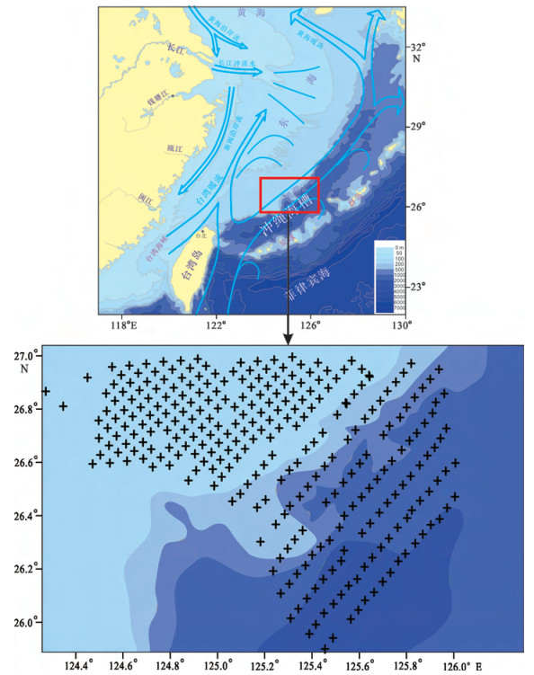
2014—2015年, 青岛海洋地质研究所通过箱式取样器采取了293个表层沉积物样品, 本文测试所用样品都取在浅表层0~2cm。涉及的沉积物区域范围覆盖东海外陆架、陆坡、冲绳海槽3个不同沉积单元。各个站位具体分布见图 1。
![图 1 研究区地质背景及站位分布]() 图 1 研究区地质背景及站位分布Figure 1. Geological background of the research area, and samples location
图 1 研究区地质背景及站位分布Figure 1. Geological background of the research area, and samples location从293个原始样品中各取样10~20g进行粒度分析。经双氧水和稀盐酸浸泡处理, 除掉有机质和碳酸盐, 然后洗盐, 用六偏磷酸钠溶液经超声波分散后, 用英国马尔文(MLVERN)公司生产的Mastersizer-2000型激光粒度分析仪进行粒度测试。该仪器的测量范围为0.02~2000μm, 偏差 < 1%, 重现性Φ50 < 1%。最后对测量数据采用矩法计算了平均粒径、分选系数、偏态和峰态等粒度参数[22]。
选取陆坡及冲绳海槽139个深水表层沉积物样品进行黏土矿物分析, 经蒸馏水水洗两次剔除盐分, 加入适量H2O2剔除有机质, 然后加入浓度为0.1mol/L的六偏磷酸钠分散剂, 静置过夜, 依据Stokes沉降原理提取 < 2μm的悬浊液, 至少提取5次, 利用真空泵把黏土矿物抽滤到0.45μm微孔滤膜上, 把附有黏土矿物的微孔滤膜置于乙二醇蒸气浴中浸泡, 24h后上机分析。黏土矿物测试所用仪器为日本产D/Max-rA型X射线衍射仪(Cu靶、管电40kV、管电流80mA、步进长度(2θ) 0.02°)。
黏土矿物的鉴定和解释主要依据三种测试条件下获得的XRD叠加波谱的综合对比, 每个波峰参数的半定量计算参照文献[23, 24], 使用Jade 5.0软件在乙二醇曲线上进行, 分析误差约5%。黏土矿物的相对含量主要使用(001)晶面衍射峰的面积比, 蒙脱石(含伊利石/蒙脱石随机混层矿物)采用1.7nm (001)晶面, 伊利石采用其1nm (001)晶面, 高岭石(001)和绿泥石(002)使用0.7nm叠加峰, 他们的相对比例通过拟合0.357nm/0.354nm峰面积比确定。粒度和黏土矿物测试分析均在国土资源部海洋地质实验检测中心完成。
3. 结果
3.1 表层沉积物粒度组分特征
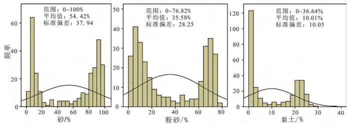
研究区沉积物颗粒按粒径大小可分为砂(2~0.063mm)、粉砂(0.063~0.004mm)和黏土(< 0.004mm) 3个粒级组分。根据粒度分析结果, 绘制了砂、粉砂和黏土粒级组分百分含量统计图(图 2)。可以看出, 砂粒级组分是研究区的优势粒级, 平均含量高达54.42%, 其次为粉砂粒级组分(均值为35.58%), 黏土粒级组分含量最低(均值为10.01%)。此外, 研究区砂粒组分和粉砂粒级的百分含量变化范围较大, 标准偏差也有类似规律。
![图 2 研究区表层沉积物各粒度组分百分含量频率图]() 图 2 研究区表层沉积物各粒度组分百分含量频率图Figure 2. Grain size frequency diagrams of surface sediment of the research area
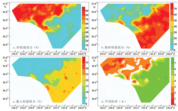
图 2 研究区表层沉积物各粒度组分百分含量频率图Figure 2. Grain size frequency diagrams of surface sediment of the research area砂粒级、粉砂粒级及黏土粒级组分平面分布如图 3a, b, c所示。砂粒级组分高值区主要分布在东海外陆架, 而低值区主要分布在冲绳海槽内。从东海外陆架→陆坡→冲绳海槽, 砂粒组分百分含量从最高的100%减小到0, 全距值高达100%。虽然东海外陆架在3个沉积单元中水深最浅, 但水深仍高达100~150m, 砂粒级组分高值区出现在东海外陆架, 应与全新世早期的“残留沉积”有关(见下文的讨论)。然而, 粉砂和黏土粒级组分百分含量平面分布特征与砂粒级组分相反, 其高值区主要分布在冲绳海槽内, 而低值区主要位于东海外陆架。研究区沉积物粒度整体呈现为随着水深的增加沉积物粒度逐渐变细。这一现象可从沉积物平均粒径平面分布图上看出, 随着水深的增加平均粒径Φ值逐渐变大。
![图 3 研究区表层沉积物砂粒级组分(a)、粉砂粒级组分(b)、黏土粒级组分(c)及平均粒径(d)平面分布图]() 图 3 研究区表层沉积物砂粒级组分(a)、粉砂粒级组分(b)、黏土粒级组分(c)及平均粒径(d)平面分布图Figure 3. Spatial distribution maps of sand, silt, and clay and mean grain size of the surface sediment in the research area
图 3 研究区表层沉积物砂粒级组分(a)、粉砂粒级组分(b)、黏土粒级组分(c)及平均粒径(d)平面分布图Figure 3. Spatial distribution maps of sand, silt, and clay and mean grain size of the surface sediment in the research area3.2 表层沉积物沉积类型特征
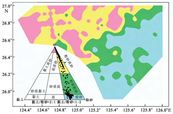
沉积物分类和命名采用Fork等人[25]提出的沉积物分类三角图解法。研究区底质类型主要由砂、粉砂质砂、砂质粉砂、粉砂组成(图 4)。东海外陆架沉积物类型主要以砂质粉砂和砂为主, 局部分布粉砂沉积物。东海陆坡沉积物类型主要以粉砂质砂、砂为主, 零星分布砂质粉砂。冲绳海槽沉积物类型主要以粉砂为主, 局部分布砂质粉砂。
![图 4 研究区表层沉积物类型平面分布图]() 图 4 研究区表层沉积物类型平面分布图Figure 4. Distribution map of surface sediments in the research area
图 4 研究区表层沉积物类型平面分布图Figure 4. Distribution map of surface sediments in the research area3.3 表层沉积物黏土矿物特征
东海陆坡及冲绳海槽表层沉积物黏土矿物测试结果见表 1。可以看出, 黏土矿物以伊利石的含量最高, 为31.0%~76.2%, 平均含量为70.0%, 标准偏差4.7;绿泥石的含量次之, 为14.8%~23.9%, 平均值为20.6%, 标准偏差1.7;高岭石含量位居第三, 为5.1%~51.2%, 平均值为7.8%, 标准偏差4.9;蒙脱石含量最低, 为0~8.0%, 平均值为1.7%, 标准偏差1.5。伊利石/蒙皂石的比值范围为8.7至无穷大; 绿泥石/高岭石的比值范围为0.3~4.6, 平均值为2.9, 标准偏差为0.5。
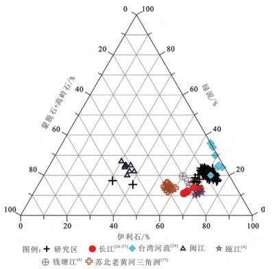
表 1 研究区及物源端元表层沉积物样品中黏土矿物含量统计Table 1. Clay mineral content in surface sediment and provenance end-members研究区 特征值 蒙皂石/% 伊利石/% 高岭石/% 绿泥石/% 伊利石/蒙皂石 绿泥石/高岭石 本文研究区 最小值 0 31.0 5.1 14.8 8.7 0.3 最大值 8.0 76.2 51.2 23.9 无穷大 4.6 平均值 1.7 70.0 7.8 20.6 2.9 标准偏差 1.5 4.7 4.9 1.7 0.5 长江[26, 27] 平均值 7.0 67.5 13.0 12.5 10.5 1.0 钱塘江[4] 2.5 62.9 17.1 6.9 44.6 0.4 瓯江[4] 8.6 65.2 9.2 11.2 11.9 1.2 闽江[4] 0.3 34.3 41.9 23.8 13.7 0.6 台湾河流[28] 0 73.3 3.5 23.3 无穷大 6.6 巽他陆架[29] 86.3 1.0 8.5 4.2 0 0.5 黄河[26] 15.2 62.5 9.7 12.5 4.1 1.3 研究区表层沉积物黏土矿物主要由伊利石-绿泥石-高岭石-蒙脱石组成, 组合类型与台湾河流物质及瓯江物质相一致, 与长江、钱塘江、闽江、巽他陆架以及黄河物质有所不同。伊利石/蒙脱石比值, 以及绿泥石/高岭石比值显示, 该区黏土矿物特征整体上与台湾河流入海泥沙的黏土矿物特征相近。通过研究区表层沉积物黏土矿物组成与潜在物源端元比较, 发现研究区黏土矿物主体上来源于台湾源入海泥沙的供应, 而个别站位可能受到闽江入海泥沙的影响。
4. 讨论
4.1 底质沉积物成因
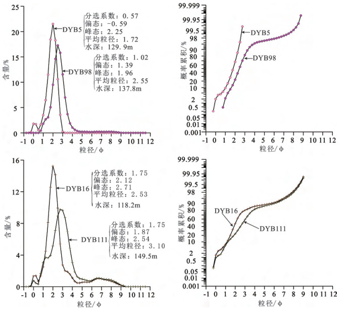
粒度分析是一种常规的沉积学研究方法, 在沉积环境和沉积过程研究中被广泛应用, 依据沉积物的粒度组成、粒度参数及各种图解可以揭示沉积环境和沉积过程特征[30]。东海外陆架大面积的砂和粉砂质砂, 分布在110~150m水深范围内(图 3)。从东海外陆架代表性站位粒度特征来看(图 5), 沉积物类型为砂的站位分选较好或者中等, 而粉砂质砂沉积物分选性差, 但它们的频率曲线上有一个明显的尖锐主峰, 频率曲线形态不对称, 正偏态值偏向粗端(2~2.5Φ); 概率曲线具有滚、跳两段式或者滚、跳、悬三段式特征, 且主要以跳移组分为主(图 5), 它们的粒度特征具有明显的海滩砂或者破浪带砂的特点[31], 与现在所处的相对低能的沉积环境不相适应。因此, 这种远离岸边分布的粗粒物质不符合一般的沉积规律, 与其现在所处的沉积动力环境不一致, 这些砂质沉积物不可能为现代河流或者沿岸侵蚀碎屑物质入海堆积所形成。AMS14 C的年代和古地磁数据显示, 东海外陆架粗粒沉积物年代较老, 一般为15~7kaBP[32, 33], 表明这些沉积物是晚更新世冰消期海侵的产物, 并非现代沉积。末次盛冰期, 当时的海面低于现今海面120~140m[34], 东海陆架外缘刚好处于滨岸沉积环境, 当时这些砂质沉积物形成于滨岸, 即临滨带高能环境; 随着冰消期海平面的上升, 临滨带向陆后退而形成区域性的海侵面, 海侵过程中因海岸带沉积物的簸选、再改造而留下相对粗粒的砂质沉积物堆积在该海侵面上往往形成席状砂[35-37]。全新世高海面以来, 中国大陆河流及台湾河流入海泥沙由于受到台湾暖流以及黑潮的阻隔而又很难扩散到东海外陆架[38], 导致这些早期形成的“残留沉积”无法被现代细粒物质所覆盖而在海底留存至今。因此, 研究区的砂以及粉砂质砂应属于古滨岸沉积环境下的“残留沉积”[8, 39, 40]。
![图 5 东海外陆架典型沉积物站位(DYB5、DYB98、DYB16、DYB111)粒径频率与概率累积曲线图]() 图 5 东海外陆架典型沉积物站位(DYB5、DYB98、DYB16、DYB111)粒径频率与概率累积曲线图Figure 5. Particle size frequency and probability cumulative curves of typical sediments in the outer continental shelf (sample DYB5、DYB98、DYB16、DYB111)
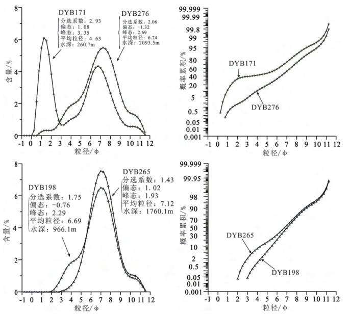
图 5 东海外陆架典型沉积物站位(DYB5、DYB98、DYB16、DYB111)粒径频率与概率累积曲线图Figure 5. Particle size frequency and probability cumulative curves of typical sediments in the outer continental shelf (sample DYB5、DYB98、DYB16、DYB111)冲绳海槽西坡典型沉积物类型由砂质粉砂组成, 沉积物分选很差, 其频率曲线呈现明显的尖锐双峰, 频率曲线形态不对称, 正偏态值偏向粗端(1.5Φ)。概率曲线具有滚、跳、悬三段式特征, 且主要以悬移组分为主, 次为滚移组分, 跳移组分含量极低(图 6), 它反映沉积水体为高密度流, 能量下降时, 搬运的悬浮负载大量迅速下沉, 随着密度降低, 重力分异, 水流牵引作用有所显露[41]。基于冲绳海槽西部陆坡沉积物粒度特征, 可以看出, 冲绳海槽西部陆坡存在重力流沉积。以往对冲绳海槽西坡开展的单道地震测量, 发现冲绳海槽西坡浊流是非常发育的, 滑塌和重力流是冲绳海槽西部陆坡碎屑沉积物向槽底搬运的重要方式, 滑塌常出现在上陆坡的断裂带处, 而重力流多位于滑塌的下方[10, 42]。
![图 6 冲绳海槽西坡、槽底典型沉积物站位(DYB171、DYB276、DYB198、DYB265)粒径频率及概率累积曲线图]() 图 6 冲绳海槽西坡、槽底典型沉积物站位(DYB171、DYB276、DYB198、DYB265)粒径频率及概率累积曲线图Figure 6. Particle size frequency and probability cumulatives curves of typical sediments in western and bottom of the Okinawa Trough (sample DYB171、DYB276, DYB198, DYB265)
图 6 冲绳海槽西坡、槽底典型沉积物站位(DYB171、DYB276、DYB198、DYB265)粒径频率及概率累积曲线图Figure 6. Particle size frequency and probability cumulatives curves of typical sediments in western and bottom of the Okinawa Trough (sample DYB171、DYB276, DYB198, DYB265)冲绳海槽槽底沉积物主要由砂质粉砂和粉砂组成, 沉积物分选较好, 其频率曲线具有明显的尖峰, 频率曲线形态不对称, 正偏态值偏向细端(7Φ) (图 6)。概率曲线具有跳、悬两段式特征, 悬移组分占比例大(图 6), 即曲线基本是由悬浮总体所组成, 体现了浊流沉积特征[41]。从我们研究区表层沉积物类型上可以看出, 槽底砂质粉砂主要沿槽轴纵向分布(图 4)。以往研究发现, 冲绳海槽西侧的陆坡宽度窄, 坡度陡, 陆坡峡谷广泛发育[42], 这种地形结构导致海槽西侧滑塌和重力流出现, 使得水深大于1000m的槽底分布有纵向形态并不连续浊积物[8, 43]; 此外, 悬浮总体主导又体现了冲绳海槽具有半深海沉积特征, 细颗粒物质通过陆架向海槽的近底侧向搬运[44-46], 或者由陆源细颗粒物质以悬浮体向外海输运的形式, 搬运至冲绳海槽沉积[46, 47]。另外, 来自槽底柱样沉积速率特征同样表明槽底具有半深海沉积特征, 槽底沉积物速率明显小于陆架而大于深海区[43]。
4.2 黏土矿物来源
黏土粒级沉积物作为边缘海环境中最细的组分, 既可以记录源区风化剥蚀、环流强度的演化、季风气候演变等环境综合信息, 又指示沉积物物质来源及搬运途径、海区沉积动力过程、河流和风尘搬运模式等物质来源信息[48-50]。一般来讲, 高岭石主要形成于温暖和潮湿的气候条件, 伊利石和绿泥石形成于相对寒冷和干旱的气候条件, 而蒙脱石与火山岩的化学风化作用密切相关[6]。本文研究区沉积物中黏土矿物组成主要受物源区的岩性, 以及搬运过程分异的制约, 通过研究区黏土矿物组成特征与物源区进行对比, 可以判别其来源。研究发现, 东海陆坡及冲绳海槽潜在的物源区包括长江、台湾河流、福建沿岸河流[4, 15, 26]。台湾河流黏土矿物以高的伊利石和绿泥石含量, 不含高岭石和蒙脱石, 且伊利石结晶度值较小为特征[28, 50]; 而长江黏土矿物以高的伊利石和少量蒙脱石, 且伊利石结晶度值较大为特征[26]。福建沿岸河流的黏土矿物则以极高的高岭石含量为特征[4]。菲律宾巽他陆架沉积物黏土矿物以极高蒙脱石含量、极低伊利石含量为特征[51]。
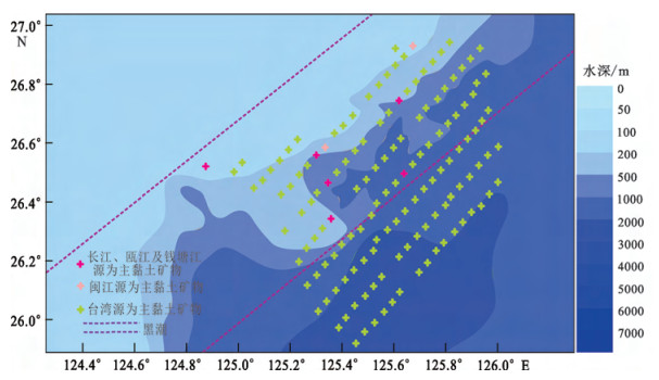
冲绳海槽中部沉积物物源研究发现, 海槽中部碎屑物质主要来源于亚洲的大河, 尤其是长江和黄河; 此外, 火山岛弧的阶段性火山喷发也为冲绳海槽提供了大量的火山碎屑物质[52]。然而, 研究区物源判别显示, 该区黏土物质主要来源于台湾岛和大陆长江、闽江等河流, 未见黄河源及火山源物质(图 7, 8)。上述与以往研究有所区别的是, 研究区域位于冲绳海槽的西南部, 更易受到台湾源物质的影响, 因而台湾物质在黏土矿物中占比例更高。我们与以往报道间的差异, 可能主要是由于我们研究区域位于冲绳海槽的西南部。在全新世中期至今, 黑潮重新进入冲绳海槽, 并将大量的台湾源物质带入冲绳海槽[15-19], 导致研究区大多数站位的黏土特征明显接近台湾源物质(图 7)。
![图 7 东海陆坡-冲绳海槽底质沉积物黏土矿物三角端元图]() 图 7 东海陆坡-冲绳海槽底质沉积物黏土矿物三角端元图Figure 7. Ternary diagram of clay minerals for the ECS continental shelf and the Okinawa Trough sediments
图 7 东海陆坡-冲绳海槽底质沉积物黏土矿物三角端元图Figure 7. Ternary diagram of clay minerals for the ECS continental shelf and the Okinawa Trough sediments![图 8 东海陆坡-冲绳海槽黏土矿物物源判别平面分布图]() 图 8 东海陆坡-冲绳海槽黏土矿物物源判别平面分布图Figure 8. Clay minerals provenance discrimination map of the ECS continental shelf and the Okinawa Trough
图 8 东海陆坡-冲绳海槽黏土矿物物源判别平面分布图Figure 8. Clay minerals provenance discrimination map of the ECS continental shelf and the Okinawa Trough此外, 从物源判别的结果来看, 东海陆坡个别站位黏土矿物组成与长江和闽江源组分十分接近(图 7, 8), 显示了中国大陆物质对冲绳海槽的影响。这些黏土矿物可以通过三种方式输运冲绳海槽:一是东海外陆架低海平面时期形成的中国大陆源的河湖相、三角洲相沉积物, 其细颗粒物质在潮流作用下不断被淘洗搬运至海槽[15, 42]; 二是东海外陆架沉积物通过滑塌和重力流的方式在陆坡形成堆积体, 存在着悬浮体由陆架向海槽的近底侧向搬运[44-46]; 三是中国大陆入海沉积物悬浮体, 以“冬贮夏输”的形式由陆架海区向深海运移[46, 47], 上述搬运模式都可以将中国大陆入海悬浮体搬运至冲绳海槽, 使得表层沉积物体现中国大陆的物源属性。
5. 结论
(1) 砂粒级组分是研究区的优势粒级, 平均含量高达54.42%, 其次为粉砂粒级组分(35.58%), 黏土粒级组分含量最低(10.01%)。本区表层沉积物底质类型主要包括砂、粉砂质砂、砂质粉砂、粉砂。从东海外陆架→陆坡→冲绳海槽, 沉积物粒度整体上逐渐变细。
(2) 外陆架-陆坡-冲绳海槽沉积物特征体现了不同沉积单元底质沉积物成因。东海外陆架沉积物具有明显的海滩砂或者破浪带砂的特征, 应为晚更新世冰消期海侵的产物, 属于“残留沉积”。冲绳海槽西坡沉积物属于重力流沉积。槽底沉积物悬移组分占主导, 一方面体现了浊流沉积特征, 另一方面体现了冲绳海槽具有半深海沉积特征。
(3) 研究区表层沉积物黏土矿物主要来源以台湾源为主, 体现了黑潮对于台湾源物质的输运; 部分黏土矿物来源于中国大陆长江、闽江等河流, 个别站位黏土矿物组成与中国大陆河流十分接近, 这些沉积物通过近底搬运、悬浮搬运等多种输运方式, 最终在冲绳海槽沉积。
致谢: 感谢2014-2015年海洋区域地质调查航次的全体科学家和船员的辛苦工作. -
![]()
图 1 研究区地质背景及站位分布
Figure 1. Geological background of the research area, and samples location
![]()
图 2 研究区表层沉积物各粒度组分百分含量频率图
Figure 2. Grain size frequency diagrams of surface sediment of the research area
![]()
图 3 研究区表层沉积物砂粒级组分(a)、粉砂粒级组分(b)、黏土粒级组分(c)及平均粒径(d)平面分布图
Figure 3. Spatial distribution maps of sand, silt, and clay and mean grain size of the surface sediment in the research area
![]()
图 4 研究区表层沉积物类型平面分布图
Figure 4. Distribution map of surface sediments in the research area
![]()
图 5 东海外陆架典型沉积物站位(DYB5、DYB98、DYB16、DYB111)粒径频率与概率累积曲线图
Figure 5. Particle size frequency and probability cumulative curves of typical sediments in the outer continental shelf (sample DYB5、DYB98、DYB16、DYB111)
![]()
图 6 冲绳海槽西坡、槽底典型沉积物站位(DYB171、DYB276、DYB198、DYB265)粒径频率及概率累积曲线图
Figure 6. Particle size frequency and probability cumulatives curves of typical sediments in western and bottom of the Okinawa Trough (sample DYB171、DYB276, DYB198, DYB265)
![]()
图 7 东海陆坡-冲绳海槽底质沉积物黏土矿物三角端元图
Figure 7. Ternary diagram of clay minerals for the ECS continental shelf and the Okinawa Trough sediments
![]()
图 8 东海陆坡-冲绳海槽黏土矿物物源判别平面分布图
Figure 8. Clay minerals provenance discrimination map of the ECS continental shelf and the Okinawa Trough
表 1 研究区及物源端元表层沉积物样品中黏土矿物含量统计
Table 1 Clay mineral content in surface sediment and provenance end-members
研究区 特征值 蒙皂石/% 伊利石/% 高岭石/% 绿泥石/% 伊利石/蒙皂石 绿泥石/高岭石 本文研究区 最小值 0 31.0 5.1 14.8 8.7 0.3 最大值 8.0 76.2 51.2 23.9 无穷大 4.6 平均值 1.7 70.0 7.8 20.6 2.9 标准偏差 1.5 4.7 4.9 1.7 0.5 长江[26, 27] 平均值 7.0 67.5 13.0 12.5 10.5 1.0 钱塘江[4] 2.5 62.9 17.1 6.9 44.6 0.4 瓯江[4] 8.6 65.2 9.2 11.2 11.9 1.2 闽江[4] 0.3 34.3 41.9 23.8 13.7 0.6 台湾河流[28] 0 73.3 3.5 23.3 无穷大 6.6 巽他陆架[29] 86.3 1.0 8.5 4.2 0 0.5 黄河[26] 15.2 62.5 9.7 12.5 4.1 1.3  下载: 导出CSV
-
[1] 郭志刚, 杨作升, 曲艳慧, 等.东海陆架泥质区沉积地球化学比较研究[J].沉积学报, 2000, 18 (22) :284-289. http://d.old.wanfangdata.com.cn/Periodical/cjxb200002020 GUO Zhigang, YANG Zuosheng, QU Yanhui, et al, Study on composition sedimentary geochemistry of mud area on East China continental shelf[J].Acta Sedimentologica Sinica, 2000, 18 (22) :284-289. http://d.old.wanfangdata.com.cn/Periodical/cjxb200002020
[2] Liu J P, Li A C, Xu K H, et al.Sedimentary features of the Yangtze River-derived alongshore clinoform deposit in the East China Sea[J].Continental Shelf Research, 2006, 26:2141-2156. doi: 10.1016/j.csr.2006.07.013
[3] Liu J P, Xu K H, Li A C, et al.Flux and fate of Yangtze River sediment delivered to the East China Sea[J].Geomorphology, 2007, 5 (3) :208-224. doi: 10.1016-j.geomorph.2006.03.023/
[4] Xu K H, Milliman J D, Li A C, et al.Yangtze-and Taiwanderived sediments on the inner shelf of East China Sea[J].Continental Shelf Research, 2009, 29 (18) :2240-2256. doi: 10.1016/j.csr.2009.08.017
[5] Xu K H, Li A C, Liu J P, et al.Provenance, structure, and formation of the mud wedge along inner continental shelf of the East China Sea:A synthesis of the Yangtze dispersal system[J].Marine Geology, 2012, 291-294:176-191. doi: 10.1016/j.margeo.2011.06.003
[6] Xu G, Liu J, Liu S F, et al.Modern muddy deposit along the Zhejiang coast in the East China Sea:response to large-scale human projects[J].Continental Shelf Research, 2016, 130:68-78. doi: 10.1016/j.csr.2016.10.007
[7] 李广雪, 杨子赓, 刘勇, 等.中国东部海域海底沉积环境成因研究[M].北京:科学出版社, 2005. LI Guangxue, YANG Zigeng, LIU Yong, et al.A Study on the Genesis of the Seabed Sedimentary Environment in the Eastern China Sea[M].Beijing:Science Press, 2005.
[8] 何起祥, 等.中国海洋沉积地质学[M].北京:海洋出版社, 2006. HE Qixiang, et al.Marine sedimentary geology of China[M].Beijing:Ocean Press, 2006.
[9] Liu Z X, Berné S, Saito Y, Yu H J, et al.Internal architecture and mobility of tidal sand ridges in the East China Sea[J].Continental Shelf Research, 2007, 27 (13) :1820-1834. doi: 10.1016/j.csr.2007.03.002
[10] 刘保华, 李西双, 赵月霞, 等.冲绳海槽西部陆坡碎屑沉积物的搬运方式:滑塌和重力流[J].海洋与湖沼, 2005, 36 (1) :1-9. doi: 10.3321/j.issn:0029-814X.2005.01.001 LIU Baohua, LI Xishuang, ZHAO Yuexia, et al.Debris transport of the western continental slope of the Okinawa Trough:Slumping and gravity flowing[J].Oceanologia et Etlimnologia Sinica, 2005, 36 (1) :1-9. doi: 10.3321/j.issn:0029-814X.2005.01.001
[11] 杨作升, Milliman J D.长江入海沉积物的输送及其入海后的运移[J].山东海洋学院学报, 1983, 13 (3) :1-12. YANG Zuosheng, Milliman J D.Characteristics of sediment transport of Changjiang River and its depsotion in the East China Sea[J].Journal of Shandong College of Oceanology, 1983, 13 (3) :1-12.
[12] 翟世奎, 陈志华, 徐善民, 等.冲绳海槽北部稀土元素沉积地球化学研究[J], 海洋地质与第四纪地质, 1996, 16 (2) :47-56. doi: 10.1007/BF02029074 ZHAI Shikui, CHEN Zhihua, XU Shanmin, et al.Geochemical characteristics of rare earth elements in the sediments of North Okinawa Trough[J].Marine Geology and Quaternary Geology, 1996, 16 (2) :47-56. doi: 10.1007/BF02029074
[13] 蒋富清, 李安春.冲绳海槽南部表层沉积物地球化学特征及其物源和环境指示意义[J].沉积学报, 2002, 20 (4) :680-686. doi: 10.3969/j.issn.1000-0550.2002.04.024 JIANG Fuqing, LI Anchun.Geochemical characteristics and their implications to provenance and environment of surface sediments from the South Okinawa Trough[J].Acta Sedimentologica Sinica, 2002, 20 (4) :680-686. doi: 10.3969/j.issn.1000-0550.2002.04.024
[14] 李萍, 李培英, 张晓龙, 等.冲绳海槽沉积物不同粒级的磁性特征及其与环境的关系[J].科学通报, 2005, 50 (3) :262-268. doi: 10.3321/j.issn:0023-074X.2005.03.011 LI Ping, LI Peiying, ZHANG Xiaolong, et al.Magnetic properties of different grain-sized particles of sediments from the Okinawa Trough and their relationships to sedimentary environment[J].Chinese Science Bulletin, 2005, 50 (3) :262-268. doi: 10.3321/j.issn:0023-074X.2005.03.011
[15] Dou Y G, Yang S Y, Liu Z X, et al.Provenance discrimination of siliciclastic sediments in the middle Okinawa Trough since 30ka:Constraints from rare earth element compositions[J].Marine Geology, 2010, 275 (1-4) :212-220. doi: 10.1016/j.margeo.2010.06.002
[16] Dou Y G, Yang S Y, Liu Z X, et al.Sr-Nd isotopic constraints on terrigenous sediment provenances and Kuroshio Current variability in the Okinawa Trough during the late Quaternary[J].Palaeogeography Palaeoclimatology Palaeoecology, 2012, 365-366 (9) :38-47. http://www.wanfangdata.com.cn/details/detail.do?_type=perio&id=5597ec4764e737369b98412caa762c73
[17] Dou Y G, Yang S Y, Shi X F, et al.Provenance weathering and erosion records in southern Okinawa Trough sediments since 28 ka:Geochemical and Sr-Nd-Pb isotopic evidences[J].Chemical Geology, 2016, 425:93-109. doi: 10.1016/j.chemgeo.2016.01.029
[18] Wang J Z, Li A C, Xu K H, et al.Clay mineral and grain size studies of sediment provenances and paleoenvironment evolution in the middle Okinawa Trough since 17ka[J].Marine Geology, 2015, 366:49-61. doi: 10.1016/j.margeo.2015.04.007
[19] Chen C T A, Kandasamy S, Chang Y P, et al.Geochemical evidence of the indirect pathway of terrestrial particulate material transport to the Okinawa Trough[J].Quaternary International, 2016, 441:51-61. http://www.wanfangdata.com.cn/details/detail.do?_type=perio&id=237c2bb966dd73470278a215c385a400
[20] 秦蕴珊, 赵一阳, 等.东海地质[M].北京:科学出版社, 1987. QIN Yunshan, ZHAO Yiyang, et al.Geology of the East China Sea[M].Beijing:Science Press, 1987.
[21] 向荣, 李铁刚, 杨作升, 等.冲绳海槽南部海洋环境改变的地质记录[J].科学通报, 2003, 48 (1) :78-82. http://d.old.wanfangdata.com.cn/Periodical/kxtb200301020 XIANG Rong, LI Tiegang, YANG Zuosheng, et al.Geological records of marine environmental changes in the southern Okinawa Trough[J].Chinese Science Bulletin, 2003, (2) :194-199. http://d.old.wanfangdata.com.cn/Periodical/kxtb200301020
[22] McManus J.Grain size determination and interpretation[C]//In: Tucker M, ed.Techniques in sedimentology.Blackwell, Oxford, 1988: 63-85.
[23] Biscaye P E.Mineralogy and sedimentation of recent deep-sea clay in the Atlantic Ocean and adjacent seas and oceans[J].GSA Bull, 1965, 76:803-832. doi: 10.1130/0016-7606(1965)76[803:MASORD]2.0.CO;2
[24] Biscaye P E, Grousset F E, Revel M, et al.Asian provenance of glacial dust (stage 2) in the Greenland Ice Sheet Project 2Ice Core, Summit, Greenland[J].Journal of Geophysical Research Oceans, 1997, 102:26765-26781. doi: 10.1029/97JC01249
[25] Folk R L, Andrews P B, Lewis D W.Detrital sedimentary rock classification and nomenclature for use in New Zealand[J].New Zealand Journal of Geology & Geophysics, 1970, 13:937-968.
[26] 范德江, 杨作升, 毛登, 等.长江与黄河沉积物中黏土矿物及地化成分的组成[J].海洋地质与第四纪地质, 2001, 21 (4) :7-12. http://www.cnki.com.cn/Article/CJFDTotal-HYDZ200104001.htm FAN Dejiang, YANG Zuosheng, MAO Deng, et al.Clay minerals geochemistry of the sediments from the Yangtze and Yellow River[J].Marine Geology and Quaternary Geology, 2001, 21 (4) :7-12. http://www.cnki.com.cn/Article/CJFDTotal-HYDZ200104001.htm
[27] Yang S Y, Jung H S, Lim D, et al.A review on the provenance discrimination of sediments in the Yellow Sea[J].Earth-Science Reviews, 2003, 63:93-120. doi: 10.1016/S0012-8252(03)00033-3
[28] Li C S, Shi X F, Kao S J, et al.Clay mineral composition and their sources for the fluvial sediments of Taiwanese rivers[J].Chinese Science Bulletin, 2012, 57 (6) :673-681. doi: 10.1007/s11434-011-4824-1
[29] Liu Z, Zhao Y, Colin C, et al.Chemical weathering in Luzon, Philippines from clay mineralogy and major-element geochemistry of river sediments[J].Applied Geochemistry, 2009, 24:2195-2205. doi: 10.1016/j.apgeochem.2009.09.025
[30] Gao S, Collins M B.Analysis of grain size trends, for defining sediment transport pathways in marine environments[J].Journal of Coastal Research, 1994, 10 (1) :70-78. doi: 10.1142/S0218127494001350
[31] 李粹中.南海中部沉积物的粒度结构和沉积环境[J].东海海洋, 1987, 5 (1-2) :109-116. LI Cuizhong.Grain-size parameters and depositional environment of modern sediments in Central South China Sea[J].Donghai Marine Science, 1987, 5 (1-2) :109-116.
[32] 杨光复, 董太禄徐善民等东海大陆架南部更新世末期以来的沉积特征[C]//中国科学院海洋研究所海洋地质研究室.黄东海地质.北京: 科学出版社, 1982: 67-81. YANG Guangfu, DONG Tailu, XU Shanmin, et al.Sedimentary characteristics on the southern shelf of the East China Sea since late stage of middle Pleistocene[C]//Research Laboratory of Marine Geology in Institute of Oceanology, Chinese Academy of Sciences (ed.).Geology of the Yellow Sea and the East China Sea.Beijing: SciencePress, 1982: 67-81.
[33] 王中波, 杨守业, 张志珣, 等.东海陆架中北部沉积物粒度特征及其沉积环境[J].海洋与湖沼, 2012, 43 (6) :1039-1049. http://d.old.wanfangdata.com.cn/Periodical/hyyhz201206003 WANG Zhongbo, YANG Shouye, ZHANG Zhixun, et al.The grains size compositions of the surface sediments in the East China Sea:Indication for sedimentary environments[J].Oceanologia et Limnologia Sinica, 2012, 43 (6) :1039-1049. http://d.old.wanfangdata.com.cn/Periodical/hyyhz201206003
[34] Yoo D G, Lee C W, Kim S P, et al.Late Quaternary transgressive and highstand systems tracts in the northern East China Sea mid-shelf[J].Marine Geology, 2002, 187:313-328. doi: 10.1016/S0025-3227(02)00384-5
[35] Goff J A, Swift D J P, Duncan S C, et al.High-resolution swath sonar investigations of sand ridge, dune and ribbon morphology in the offshore environment of the New Jersey margin[J].Marine Geology, 1999, 161:307-337. doi: 10.1016/S0025-3227(99)00073-0
[36] Duncan C S, Goff J A, Austin J.Tracking the last sea-level cycle:seafloor morphology and shallow stratigraphy of the latest Quaternary New Jersey middle continental shelf[J].Marine Geology, 2000, 170:395-424. doi: 10.1016/S0025-3227(00)00082-7
[37] 徐刚, 刘健, 温春, 等.南黄海西部陆架区表层沉积特征与物源分析[J].海洋地质与第四纪地质, 2010, 30 (4) :49-56. http://www.wanfangdata.com.cn/details/detail.do?_type=perio&id=hydzydsjdz201004007 Xu Gang, Liu Jian, Wen Chun, et al.Sedimentary characteristics and provenance of surficial sediments in the west South Yellow Sea[J].Marine Geology and Quaternary Geology, 2010, 30 (4) :49-56. http://www.wanfangdata.com.cn/details/detail.do?_type=perio&id=hydzydsjdz201004007
[38] Milliman J D, Shen H T, Yang Z S, et al.Transport and deposition of river sediment in the Changjiang estuary and adjacent continental shelf[J].Continental Shelf Research, 1985, 4:37-45. doi: 10.1016/0278-4343(85)90020-2
[39] 沈华悌.东海陆架残留沉积时代和成因模式[J].海洋学报, 1985, 7 (1) :67-77. http://www.hyxb.org.cn/aos/ch/reader/view_abstract.aspx?flag=1&file_no=19850108&journal_id=aos SHEN Huati.The residual sedimentary age and genetic model of the East China Sea shelf[J].Acta Oceanologica Sinica, 1985, 7 (1) :67-77. http://www.hyxb.org.cn/aos/ch/reader/view_abstract.aspx?flag=1&file_no=19850108&journal_id=aos
[40] 刘锡清.中国陆架的残留沉积[J].海洋地质与第四纪地质, 1987, 7 (1) :1-14. http://www.cnki.com.cn/Article/CJFDTotal-HYDZ198701000.htm LIU Xiqing.Relict sediments in China continental shelf[J].Marine Geology and Quaternary Geology, 1987, 7 (1) :1-14. http://www.cnki.com.cn/Article/CJFDTotal-HYDZ198701000.htm
[41] 郑浚茂.陆源碎屑沉积环境的粒度标志[D].武汉地质学院北京研究生部, 1982. ZHENG Junmao.Granularity markers of terrestrial detrital sedimentary environment[D].Graduate Department of Beijing Institute of Geology, Wuhan, 1982.
[42] 李巍然, 杨作升, 王琦, 等.冲绳海槽陆源碎屑峡谷通道搬运与海底扇沉积[J].海洋与湖沼, 2001, 32 (4) :371-380. doi: 10.3321/j.issn:0029-814X.2001.04.004 LI Weiran, YANG Zuosheng, WANG Qi, et al.Terrigenous transport through canyon and sedimentation of submarine fan in the Okinawa Trough[J].Oceanologia et Limnologia Sinica, 2001, 32 (4) :371-380. doi: 10.3321/j.issn:0029-814X.2001.04.004
[43] 袁迎如.冲绳海槽的浊流沉积物[J].地质论评, 1987, 33 (6) :499-505. doi: 10.3321/j.issn:0371-5736.1987.06.001 YUAN Yingru.Turbidities in the Okinawa Trough[J].Geological review, 1987, 33 (6) :499-505. doi: 10.3321/j.issn:0371-5736.1987.06.001
[44] Honda M, Kusakabe M, Nakabayashi S.Radiocarbon of sediment trap samples from the Okinawa Trough:lateral transport of 14C-poor sediment from the continental slope[J].Marine Chemistry, 2000, 68:231-247. doi: 10.1016/S0304-4203(99)00080-8
[45] Oguri K, Matsumoto E, Yamada M, et al.Sediment accumulation rates and budgets of deposing particles of the East China Sea[J].Deep Sea Research Part Ⅱ, 2003, 50:513-528. doi: 10.1016/S0967-0645(02)00465-4
[46] Iseki K, Okamura K, Kiyomoto Y.Seasonality and composition of downward particulate fluxes at the continental shelf and Okinawa Trough in the East China Sea[J].Deep Sea Research Part Ⅱ, 2003, 50:457-473. http://www.wanfangdata.com.cn/details/detail.do?_type=perio&id=f469580e853f4132985ed1f276bfb911
[47] 杨作升, 郭志刚.黄东海陆架悬浮体向其东部深海区输送的宏观格局[J].海洋学报, 1992, 14 (2) :81-90. doi: 10.1007/BF02677081 YANG Zuosheng, GUO Zhigang.The macro pattern of the suspended body of the Yellow Sea and the East China Sea to the eastern deep sea area[J].Acta Oceanologica Sinica, 1992, 14 (2) :81-90. doi: 10.1007/BF02677081
[48] 梁小龙, 杨守业, 印萍, 等.黄海与东海周边河流及泥质区沉积物黏土矿物的分布特征和控制因素[J].海洋地质与第四纪地质, 2015, 35 (6) :1-15. http://www.wanfangdata.com.cn/details/detail.do?_type=perio&id=hydzydsjdz201506001 LIANG Xiaolong, YANG Shouye, YIN Ping, et al.Distribution of clay mineral assemblage in the rivers entering Yellow Sea and East China Sea and the muddy shelve deposits and control factors[J].Marine Geology and Quaternary Geology, 2015, 35 (6) :1-15. http://www.wanfangdata.com.cn/details/detail.do?_type=perio&id=hydzydsjdz201506001
[49] 王亮, 范德江, 李巍然, 等.东海内陆架泥质区百年来黏土矿物组成变化及其环境意义[J].海洋学报, 2015, 37 (5) :87-100. doi: 10.3969/j.issn.0253-4193.2015.05.009 WANG Liang, FAN Dejing, LI Weiran, et al.The variation of clay minerals contents on the inner shelf of the East China Sea in the last one hundred years and its environmental implications[J].Acta Oceanologica Sinica, 2015, 37 (5) :87-100. doi: 10.3969/j.issn.0253-4193.2015.05.009
[50] Liu Z, Tuo S, Colin C, et al.Detrital fine-grained sediment contribution from Taiwan to the northern South China Sea and its relation to regional ocean circulation[J].Marine Geology, 2008, 255 (3-4) :149-155. doi: 10.1016/j.margeo.2008.08.003
[51] Xu Z K, Li T G, Wan S M, et al.Evolution of East Asian Monsoon:Clay mineral evidence in the western Philippine Sea over the past 700kyr[J].Journal of Asian Earth Sciences, 2012, 60:188-196. doi: 10.1016/j.jseaes.2012.08.018
[52] 赵德博, 万世明.冲绳海槽沉积物物源示踪研究进展[J].海洋地质前沿, 2015, 31 (2) :32-41. http://d.old.wanfangdata.com.cn/Periodical/hydzdt201502005 ZHAO Debo, WAN Shiming.Research progress of tracing sediment sources in Okinawa Trough[J].Marine Geology Frontiers, 2015, 31 (2) :32-41. http://d.old.wanfangdata.com.cn/Periodical/hydzdt201502005