SEDIMENT COMPACTION IN DEEPWATER BASIN OF SOUTH CHINA SEA AND EFFECTING FACTORS
-
摘要: 深水盆地沉积物的压实作用直接关系到沉积物本身的稳定性,沉积物压实不均衡可能引发严重的深水地质灾害,如海底滑坡、浅层气、浅水流等,同时对钻井工程也会造成严重影响,如出现井漏、井喷,甚至引发平台不稳定至坍塌。选取了南海深水盆地ODP184航次1144、1146、1148站位与IODP349航次U1431、U1432、U1433、U1435站位的测井数据进行分析,获得了南海深水盆地沉积物正常压实系数与沉积物组分、沉积速率、沉积物埋深等多个影响因素的关系,初步建立起南海深水盆地不同深度沉积物正常压实系数与初始孔隙度的变化规律。为今后研究南海深水盆地地质灾害,特别是超压地质灾害提供参考。Abstract: The stability of sediments is closely related to sediment compaction in deepwater basins. Facts suggest that uneven compaction of sediments may trigger serious geodisasters in deepwater, such as submarine landslides, shallow gas and shallow water flow, which may bring about serious impacts on the security of the drilling operation by leakages, blowouts, platform instability and even collapse. We analyzed in this paper the well-logging data of the ODP Leg 184 Sites 1144, 1146, 1148 and the IODP Leg 349 Sites U1431, U1432, U1433, U1435, and found the relationships between the normal compaction and the sediments composition, sedimentation rates and burial depth etc. Taking the deepwater basin of the South China Sea as examples. Established upon the research are the primary relationship of the coefficients of normal compaction and mudline porosity with depth in deepwater basin of the South China Sea. The results could be used as a reference for geohazards researches, especially for the overpressured geohazards in deepwater.
-
深水盆地沉积物的压实状态直接关系到沉积物本身的稳定性以及钻井工程的安全问题,随着近年南海北部深水盆地油气资源的开发,钻井灾害的预防越来越受到重视,特别是浅层地质灾害,如滑坡、浅水流、浅层气、天然气水合物等[1-4]。超压是引起大部分深水盆地地质灾害的主要因素,在南海北部珠江口盆地、莺歌海盆地、琼东南盆地等也已经进行了广泛研究[5-11]。超压主要是指沉积物孔隙压力高于静水压力,超压的形成和增长会驱使沉积物结构发生变化,导致岩层破裂形成断层或造成滑坡。钻井过程中,钻井液的注入低于超压值会造成井漏,而高于超压值会造成围岩破坏,未固结沉积物上涌[1-2, 4, 12]。超压问题的解决是南海北部深水盆地油气资源钻探开发的重点研究对象。
孔隙压力是指沉积物孔隙中流体的压力,现阶段主要的孔隙压力预测方法都是基于Eaton和Bowers的经典方法改进而来[13-20]。孔隙压力的预测需要利用沉积物正常压实系数来实现计算,正常压实系数是根据相关沉积物正常压实层段测井数据,如孔隙度、声波时差等进行拟合获得[8, 10, 21, 22]。沉积物的正常压实是通过上覆沉积物的不断沉积,对下伏沉积物加压使其孔隙内流体随时间、压力增加逐渐排出而进行的[14],这一过程可能受沉积物组成成分、沉积速率、沉积区域、沉积物埋藏深度、计算拟合方式等的影响,从而造成不同的结果。
本文旨在通过对ODP184航次1144、1146、1148站位与IODP349航次U1431、U1432、U1433、U1435站位的测井数据进行分析,通过正常压实沉积物孔隙度随深度呈指数变化的关系来拟合不同情况下南海深水盆地沉积物的正常压实系数与初始孔隙度,分析南海深水盆地沉积物正常压实系数的影响因素与变化规律,为今后南海深水盆地超压预测提供有效的借鉴与参考,获得更加有效、精确的超压预测值。
1. 地质背景
南海是西太平洋面积最大的边缘海,处于欧亚板块、太平洋板块和印度-澳大利亚板块3大板块的边界地带,共计约35 000 000 km2(图 1)。南海在各大板块与地幔物质的共同作用下经历了复杂的演化历史[23]。现今的南海主要是在渐新世-中新世时期洋壳沿WSW-ENE向扩张而成[24, 25]。新生代南海的构造演化主要分为始新世-渐新世裂谷期和新近纪-第四纪裂后沉降期两个阶段[26-29],经历了从早期湖泊相、海湾浅海相,到最终的开阔大洋沉积环境的演化过程[28, 29]。
![]() 图 1 研究区域构造划分与地形地貌Figure 1. The tectonic division and Geomorphologic map of the study area
图 1 研究区域构造划分与地形地貌Figure 1. The tectonic division and Geomorphologic map of the study areaODP184航次是中国南海首次深水钻探航次,主要钻探了南海北部陆坡6个站位的17口井,共钻取了5 463 m沉积物,其中32 Ma以来的深水沉积层序记录了南海扩张后的整个沉积环境演化历史[30]。1144站位位于南海北部陆坡的一个厚层沉积漂积体中,具有高沉积速率,水深2 037 m,最大钻进深度453 m,250 m以上平均沉积速率达0.87 mm/a(图 1)。1146站位位于南海北部中部陆坡小型裂谷盆地内,水深2 092 m,最大钻进深度607 m, 沉积速率较稳定,在更新世时期的最大平均沉积速率只有0.15 mm/a,分布着连续的半深海沉积层序。1148站位位于ODP184航次中南海北部陆坡边缘最深处,接近于洋陆边界,水深3 246 m,最大钻进深度853 m,沉积速率变化较大,中间还存在3 Ma的沉积缺失[31]。
IODP349航次在南海深水盆地主要钻探了5个站位,其中在扩张中心附近的3个(U1431, U1433和U1434)钻穿了洋壳[32](图 1)。U1431站位位于南海中央海盆残余扩张中心附近,水深4 237 m,最大钻进深度1 008 m,周围被洋壳上海山等洋底高地包围,属于远洋沉积。U1432站位位于1148站位南部约60 km处,处于洋陆边界地带,水深3 829 m,最大钻进深度110 m,钻取沉积物年龄不超过0.91 Ma。U1433站位位于南海中央海盆南部残余扩张中心附近,水深4 379 m,最大钻进深度857 m,早中新世到中中新世沉积物沉积速率极低(∠0.005 m/a), 晚中新世到早更新世沉积物沉积速率在0.05~0.09 mm/a,之后在1 Ma内快速上升到0.2 mm/a。U1435站位位于洋陆边界地带,作为U1432站位的补充,水深3 252 m,最大钻进深度300 m[32]。
2. 数据与方法
本研究使用的测井孔隙度数据均来自于ODP184航次与IODP349航次初始报告,是由岩心干湿样品的质量和体积测量获得。这一方法主要是利用对流烘箱将湿样放置在温度为100~110 ℃中烘干24 h,这样不仅除去了孔隙水,但也除去了大量存在于黏土矿物(如蒙脱石)内的层间水(结合水),导致计算的孔隙度偏大约20%[33]。层间水对有效压实的孔隙流体压力并无作用,所以本文使用孔隙度数据都经过了20%的误差校正。
沉积物正常压实孔隙度随深度(海底泥线以下)呈指数变化[20, 34]:
$$ {\phi _n} = {\phi _0}{e^{ - cz}} $$ (1) 式中,ϕn为实际孔隙度;ϕ0为初始孔隙度(海底泥线处);c 为沉积物正常压实系数;z 为海底泥线下深度。通过ODP184航次与IODP349航次各站位测井孔隙度数据随深度变化情况识别出正常压实沉积物层段,在科学绘图软件Grapher9.0上利用公式(1)对测井孔隙度数据与深度进行拟合,获得沉积物正常压实系数与初始孔隙度。
3. 结果与讨论
3.1 沉积物的正常压实
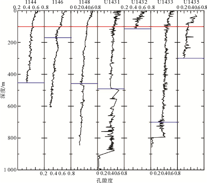
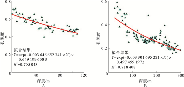
ODP184航次与IODP349航次各站位沉积物正常压实层段,孔隙度随深度(海底泥线以下,以下简称深度)呈指数变化趋势,其中1144站位正常压实层段沉积物深度为450 m, 1146站位为170 m,1148站位为460 m, U1431站位为500 m, U1432站位为120 m, U1433站位为700 m,U1435站位为300 m(图 2)。通过公式(1)对各站位钻井正常压实沉积物层段进行拟合,同时对所有站位钻井深度100 m以上沉积物进行拟合(图 3-7)。
![]() 图 2 南海深水盆地ODP184航次1144、1146、1148站位与IODP349航次U1431、U1432、U1433、U1435站位孔隙度随深度(海底泥线以下)变化趋势图(红线为钻井深度100 m所处位置,蓝线为各站位钻井沉积物正常压实层段深度所处位置)Figure 2. The porosity versus depth (below the mudine) at ODP Leg 184 Site 1144、1146、1148 and IODP Leg 349 Site U1431、U1432、U1433、U1435 in deepwater basin of the South China Sea(Red line is the location of 100 m drilling depth, blue line is the depth of the normal compaction sediments)
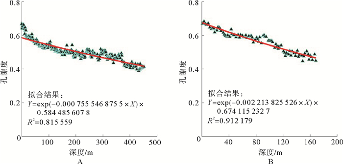
图 2 南海深水盆地ODP184航次1144、1146、1148站位与IODP349航次U1431、U1432、U1433、U1435站位孔隙度随深度(海底泥线以下)变化趋势图(红线为钻井深度100 m所处位置,蓝线为各站位钻井沉积物正常压实层段深度所处位置)Figure 2. The porosity versus depth (below the mudine) at ODP Leg 184 Site 1144、1146、1148 and IODP Leg 349 Site U1431、U1432、U1433、U1435 in deepwater basin of the South China Sea(Red line is the location of 100 m drilling depth, blue line is the depth of the normal compaction sediments)![]() 图 3 1144站位钻井沉积物正常压实层段(450 m)孔隙度与深度(海底泥线以下)拟合结果(A)及正常压实层段(170 m)孔隙度与深度(海底泥线以下)拟合结果(B)(红线为拟合曲线)Figure 3. A. Fitted result of porosity and depth (below the mudline) in normal compaction sediments (450 m) at Site 1144; B. Fitted result of the porosity and depth (below the mudline) in normal compaction sediments (170 m) at Site 1146;(Red lines are the fitted curves)
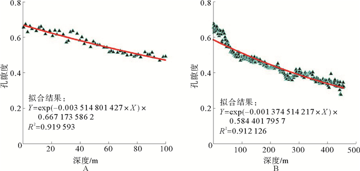
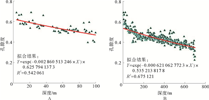
图 3 1144站位钻井沉积物正常压实层段(450 m)孔隙度与深度(海底泥线以下)拟合结果(A)及正常压实层段(170 m)孔隙度与深度(海底泥线以下)拟合结果(B)(红线为拟合曲线)Figure 3. A. Fitted result of porosity and depth (below the mudline) in normal compaction sediments (450 m) at Site 1144; B. Fitted result of the porosity and depth (below the mudline) in normal compaction sediments (170 m) at Site 1146;(Red lines are the fitted curves)![]() 图 4 1148站位钻井深度100 m以上沉积物正常压实孔隙度与深度(海底泥线以下)拟合结果(A)及钻井沉积物正常压实层段(460 m)孔隙度与深度(海底泥线以下)拟合结果(B)(红线为拟合曲线)Figure 4. A. Fitted result of porosity and depth (below the mudline) in 100 m drilling depth at Site 1148; B. Fitted result of the porosity and depth (below the mudline) in normal compaction sediments (460 m) at Site 1148(Red lines are the fitted curves)
图 4 1148站位钻井深度100 m以上沉积物正常压实孔隙度与深度(海底泥线以下)拟合结果(A)及钻井沉积物正常压实层段(460 m)孔隙度与深度(海底泥线以下)拟合结果(B)(红线为拟合曲线)Figure 4. A. Fitted result of porosity and depth (below the mudline) in 100 m drilling depth at Site 1148; B. Fitted result of the porosity and depth (below the mudline) in normal compaction sediments (460 m) at Site 1148(Red lines are the fitted curves)![]() 图 5 U1431站位钻井深度100 m以上沉积物正常压实孔隙度与深度(海底泥线以下)拟合结果(A)及沉积物正常压实层段(500 m)孔隙度与深度(海底泥线以下)拟合结果(B)(红线为拟合曲线)Figure 5. A. Fitted result of porosity and depth (below the mudline) in 100 m drilling depth at Site U1431; B. Fitted result of the porosity and depth (below the mudline) in normal compaction sediments (500 m) at Site U1431(Red lines are the fitted curves)
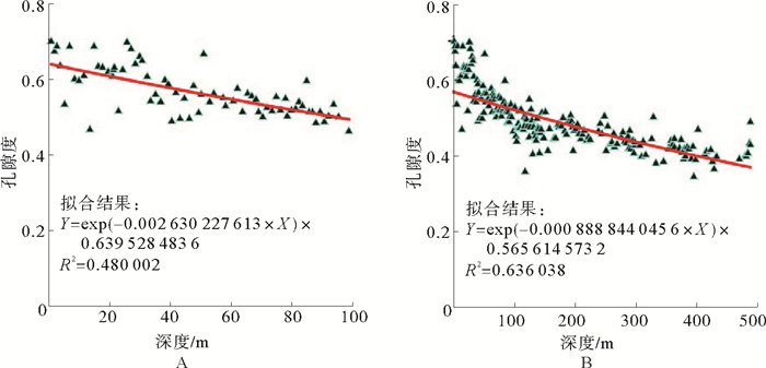
图 5 U1431站位钻井深度100 m以上沉积物正常压实孔隙度与深度(海底泥线以下)拟合结果(A)及沉积物正常压实层段(500 m)孔隙度与深度(海底泥线以下)拟合结果(B)(红线为拟合曲线)Figure 5. A. Fitted result of porosity and depth (below the mudline) in 100 m drilling depth at Site U1431; B. Fitted result of the porosity and depth (below the mudline) in normal compaction sediments (500 m) at Site U1431(Red lines are the fitted curves)![]() 图 6 U1432站位钻井沉积物正常压实层段(120 m)孔隙度与深度(海底泥线以下)拟合结果(A)及U1435站位钻井沉积物正常压实层段(300 m)孔隙度与深度(海底泥线以下)拟合结果(B)(红线为拟合曲线)Figure 6. A. Fitted result of porosity and depth (below the mudline) in normal compaction sediments (120 m) at Site U1432; B. Fitted result of the porosity and depth (below the mudline) in normal compaction sediments (300 m) at Site U1435(Red lines are the fitted curves)
图 6 U1432站位钻井沉积物正常压实层段(120 m)孔隙度与深度(海底泥线以下)拟合结果(A)及U1435站位钻井沉积物正常压实层段(300 m)孔隙度与深度(海底泥线以下)拟合结果(B)(红线为拟合曲线)Figure 6. A. Fitted result of porosity and depth (below the mudline) in normal compaction sediments (120 m) at Site U1432; B. Fitted result of the porosity and depth (below the mudline) in normal compaction sediments (300 m) at Site U1435(Red lines are the fitted curves)![]() 图 7 U1433站位钻井深度100 m以上沉积物正常压实孔隙度与深度(海底泥线以下)拟合结果(A)及钻井沉积物正常压实层段(700 m)孔隙度与深度(海底泥线以下)拟合结果(B)(红线为拟合曲线)Figure 7. A. Fitted result of porosity and depth (below the mudline) in 100 m drilling depth at Site U1433; B. Fitted result of the porosity and depth (below the mudline) in normal compaction sediments (700 m) at Site U1433(Red lines are the fitted curves)
图 7 U1433站位钻井深度100 m以上沉积物正常压实孔隙度与深度(海底泥线以下)拟合结果(A)及钻井沉积物正常压实层段(700 m)孔隙度与深度(海底泥线以下)拟合结果(B)(红线为拟合曲线)Figure 7. A. Fitted result of porosity and depth (below the mudline) in 100 m drilling depth at Site U1433; B. Fitted result of the porosity and depth (below the mudline) in normal compaction sediments (700 m) at Site U1433(Red lines are the fitted curves)通过对各站位钻井孔隙度与深度拟合的正常压实曲线可见(图 3-7),7个站位沉积物正常压实层段的指数拟合曲线决定系数都在0.6以上,具有很好的可靠性。其中ODP184航次的3个站位决定系数都在0.81以上,1146站位与1148站位更是在0.9以上,拟合程度非常好。IODP349航次5个站位拟合曲线决定系数都在0.6以上,较ODP184航次3个站位低,但具有可靠性。同时ODP184航次3个站位相比于IODP349航次的5个站位,数据相对于拟合曲线也表现出更明显的收敛效果。
3.2 沉积物正常压实系数影响因素分析
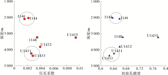
各站位正常压实沉积物由于沉积物组分、沉积速率、沉积区域与沉积物深度等的差异,其拟合的压实系数和初始孔隙度并没有明显的规律性(表 1)。通过拟合各站位钻井深度100 m以上沉积物压实系数来分析沉积物组分、沉积速率、沉积区域与沉积物深度等对沉积物压实效果的影响,其中U1435站位钻井正常压实层段沉积物(300 m)拟合与钻井深度100 m以上沉积物拟合分别表现出明显的过低初始孔隙度和过高初始孔隙度与异常压实系数,这可能与该站位浅层测井数据量有关,数据量的不足导致拟合计算过程中出现深部拟合忽略浅部少量数据和浅部拟合缺乏有效数据量收敛而出现误差,所以在分析过程中不做分析(表 2,图 8)。
表 1 各站位钻井沉积物正常压实层段孔隙度与深度(泥海底线以下)拟合结果Table 1. Fitted results of porosity and depth (below the mudline) in normal compaction sediments at all Sites站位 水深/m 拟合深度/m 压实系数 初始孔隙度 R2 1144 2 037 450 0.000 755 547 0.584 485 608 0.815 559 1146 2 092 170 0.002 213 826 0.674 115 233 0.912 179 1148 3 246 460 0.001 374 514 0.584 401 796 0.912 126 U1431 4 237 500 0.000 888 844 0.565 614 573 0.636 038 U1432 3 829 120 0.003 646 652 0.649 199 6 0.705 043 U1433 4 379 700 0.000 621 063 0.535 213 818 0.675 121 U1435 3 252 300 0.003 301 695 0.497 459 197 0.718 408 表 2 各站位钻井深度100 m以上沉积物正常压实孔隙度与深度(海底泥线以下)拟合结果Table 2. Fitted results of porosity and depth (below the mudline) in 100 m drilling depth at all Sites站位 水深/m 拟合深度/m 压实系数c 初始孔隙度ϕ0 R2 数据量 1144 2 037 100 0.002 175 931 0.635 431 987 0.871 93 73 1146 2 092 100 0.001 566 811 0.656 554 092 0.771 10 54 1148 3 246 100 0.003 514 827 0.667 174 148 0.919 59 53 U1431 4 237 100 0.002 630 228 0.639 528 484 0.480 00 71 U1432 3 829 100 0.003 993 244 0.656 653 229 0.677 15 57 U1433 4 379 100 0.002 860 513 0.625 794 137 0.542 06 57 U1435 3 252 100 0.009 452 971 0.775 503 404 0.552 29 21 ![]() 图 8 各站位钻井深度100 m以上沉积物正常压实孔隙度与深度(海底泥线以下)拟合压实系数与初始孔隙度分布Figure 8. Fitted coefficients of normal compaction and mudline porosity of porosity and depth (below the mudline) in 100 m drilling depth at all Sites
图 8 各站位钻井深度100 m以上沉积物正常压实孔隙度与深度(海底泥线以下)拟合压实系数与初始孔隙度分布Figure 8. Fitted coefficients of normal compaction and mudline porosity of porosity and depth (below the mudline) in 100 m drilling depth at all Sites通过公式(1)可知,在假设初始孔隙度相同的情况下,同一深度下,压实系数越大,孔隙度越小,沉积物压实效果越好。1144站位与1146站位水深相近,钻井深度100 m以上沉积物同属于更新世沉积[31],在拟合结果中,1146站位压实系数比1144站位小0.000 6,初始孔隙度差-0.02,1144站位区域钻井深度100 m以上沉积物相比1146站位区域较压实。1144站位所在区域是高速率沉积区,据计算1144站位钻井深度250 m以上平均沉积速率达0.87 mm/a。据Prell等(1999)研究报告, 1144站位位于南海北部陆坡的一个厚层沉积漂积体中,该处沉积漂积体是底流与南海暖流支流共同作用的结果[35],厚层沉积漂积体沉积过程中沉积物组分中较粗物质被底流冲刷带走,沉积较细的沉积物。1146站位所在区域沉积速率较稳定,在更新世时期的最大平均沉积速率只有0.15 mm/a。在钻井深度100 m以上沉积物的沉积过程中,1144站位区域沉积物普遍比1146站位区域沉积物沉积时期较新[31]。
U1431站位与U1433站位基本处于相近深度下,同属于远洋深海沉积,分别位于南海中央海盆中部残余扩张中心北侧与南海中央海盆南部残余扩张中心南侧。钻井深度100 m以上沉积物拟合压实系数相差0.000 2;初始孔隙度差-0.01。据Li等(2015)的IODP349航次报告,U1431站位钻井深度300 m以上沉积物的平均沉积速率约0.05 mm/a,100 m以上沉积物属于更新世以来沉积,主要是黏土与粉砂质黏土沉积,含有丰富的浊流形成沙质沉积物。U1433站位钻井深度200 m以上沉积物的平均沉积速率约0.2 mm/a,主要沉积黏土夹杂极少量薄层粉砂,300 m以上沉积物属于更新世以来沉积。在钻井深度100 m以上沉积物的沉积过程中,U1433站位区域沉积物明显比U1431站位区域沉积物沉积时期较新,同时沉积速率明显较快。
一般情况下,上覆低渗透率沉积物快速沉积会导致下伏沉积物孔隙中流体无法及时排除而造成高孔隙度,进而超压[14]。在钻井深度100 m以上沉积物中,1144站位与1146站位、U1431站位与U1433站位都是在相近水深处,沉积速率较快的站位区域(1144站位与U1433站位)出现沉积物压实效果更好的现象,这说明沉积速率对这两个对比区域的沉积物压实影响较小。1144站位与U1433站位钻井显示,钻井深度100 m以上沉积物组分分别要比1146站位与U1431站位沉积物组分细,这就导致了1146站位与U1431站位钻井深度100 m以上沉积物孔隙较大,压实效果较差。
通过图 8可见,在不同水深下的各站位钻井深度100 m以上沉积物压实系数并没有表现出很好的规律性。1144站位与1146站位同属于2 000 m水深,压实系数最小。U1431站位与U1433站位同属于4 300 m左右水深,压实系数大于1144站位与1146站位,但小于1148站位与U1432站位。除U1435站位拟合数据异常不做对比外,U1432站位钻井深度100 m以上沉积物压实系数最大,1148站位次之。U1432站位与1148站位位于南海北部洋陆边界地带,其中U1432站位基本处于边界上[31, 32],属于被动大陆边缘的陆隆区域。1144站位与1146站位位于南海北部陆坡上,而U1431站位与U1433站位位于南海中央海盆裂谷附近,属于远洋深海盆地沉积区域。可见不同沉积环境对沉积物正常压实具有不同的影响,南海北部洋陆边界区域压实效果最好,洋盆裂谷附近次之,陆坡上沉积物压实效果最差。
通过各站位正常压实沉积物拟合压实系数(表 1)与钻井深度100 m以上沉积物拟合压实系数(表 2)对比可见,不同深度正常压实沉积物拟合的压实系数不同。其中1148站位正常压实沉积物(460 m)拟合决定系数与钻井深度100 m以上沉积物拟合决定系数都在0.91以上,拟合效果非常好,但压实系数相差约0.002,初始孔隙度差约0.08(图 4)。U1431站位与U1433站位也表现出较大的差异性,压实系数相差约0.002,初始孔隙度分别相差约0.07与0.09(图 5, 7)。1148站位、U1431站位与U1433站位是研究井位中正常压实沉积物深度最大的3个站位,正常压实沉积物层段拟合压实系数与初始孔隙度相比钻井深度100 m以上沉积物拟合压实系数与初始孔隙度表现出明显的减小现象,压实系数减小值都在0.002左右,初始孔隙度减少值也极其相近,沉积物压实系数与初始孔隙度随深度增加呈现下降趋势。选取1144、1148与U1433站位分别代表南海北部陆坡、南海北部陆隆与洋盆沉积环境分析沉积物正常压实系数与初始孔隙度随深度的变化关系。
3.3 压实系数与初始孔隙度随深度变化趋势分析
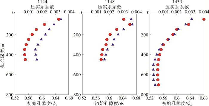
1144站位、1148站位与U1433站位从海底泥线开始,每隔50 m利用公式(1)进行一次拟合计算,每次拟合深度都是从海底泥线开始到目标深度层位,获得压实系数与初始孔隙度如图 9分布。1144站位与1148站位的拟合目标深度到450 m,共拟合9次,U1433站位的拟合目标深度到700 m,共拟合14次。
![]() 图 9 1144、1148、U1433站位各钻井深度上沉积物孔隙度与深度拟合的压实系数(红色圆点)与初始孔隙度(蓝色三角)随拟合深度(海底泥线以下)变化趋势Figure 9. Variation of the fitted coefficients of normal compaction (red dot) and mudline porosity (blue triangle) for porosity and depth (below the mudline) in different drilling depth at Site 1144、1148、U1433
图 9 1144、1148、U1433站位各钻井深度上沉积物孔隙度与深度拟合的压实系数(红色圆点)与初始孔隙度(蓝色三角)随拟合深度(海底泥线以下)变化趋势Figure 9. Variation of the fitted coefficients of normal compaction (red dot) and mudline porosity (blue triangle) for porosity and depth (below the mudline) in different drilling depth at Site 1144、1148、U1433U1433站位处于洋盆环境下,沉积速率与沉积物质都比较稳定,钻井深度700 m以上沉积物都处于正常压实状态下。通过图 9可见,U1433压实系数随深度增加呈先减小再趋于稳定的变化趋势,最后压实系数约在0.000 6左右,初始孔隙度也随深度增加呈先减小再趋于稳定的变化趋势,最终趋于0.53左右。1144站位位于南海北部陆坡沉积环境,属于受底流与暖流共同影响的厚层沉积漂积体,沉积颗粒较细,上覆钻井深度450 m以上沉积物较稳定,其压实系数随深度增加呈先减小再趋于稳定在约0.000 7左右的变化趋势,初始孔隙度也随深度增加呈先减小再趋于稳定在约0.58的变化趋势。而1148站位属于洋陆边缘沉积,其钻井深度50 m以上沉积物拟合压实系数与初始孔隙度在整体上表现出异常偏小值,压实系数随深度增加逐渐减小至0.001 4左右,初始孔隙度随深度增加逐渐减小至0.59左右,都还没有趋于稳定,变化趋势也没有1144站位与U1433站位平滑。
在正常压实环境下,1144站位与U1433站位显示,压实系数与初始孔隙度随深度增加会先减小后逐渐趋于稳定,这趋于稳定的深度应该是沉积物成岩并完全固结所在的深度。上覆浅层正常压实沉积物的拟合压实系数较大,是由于浅层沉积物孔隙中流体排除明显,而到下伏沉积物后,孔隙中流体基本已排除,沉积物已趋于完全压实固结。1148站位正常压实系数与初始孔隙度随深度增加还没有趋于稳定,可能存在孔隙流体异常与压力异常所致,沉积物还没有达到完全压实固结状态。
4. 结论
(1) 南海深水盆地沉积物正常压实效果受沉积物组分、沉积速率、沉积区域、沉积物深度等因素的影响,沉积物组分是影响正常压实系数的主要因素。南海北部陆坡、南海北部陆隆与南海洋盆等不同区域表现出明显不同的沉积物正常压实效果,其中处于洋陆边界地带的压实效果最好,压实系数最大,处于南海北部陆坡处的压实效果最差。
(2) 南海深水盆地中沉积物的压实随深度表现出明显的渐变过程。浅层沉积物孔隙度大,孔隙中流体含量充足,随着压实进行流体排出效果明显,压实系数较大。随着沉积物深度增加,压实系数逐渐减小到趋于稳定,到达沉积物已完全压实固结层位。这一压实系数的变化规律可以更好地厘定浅层正常压实沉积物层段深度,有助于今后在南海深水盆地沉积物孔隙压力和有效应力方面的研究。
-
![]()
图 1 研究区域构造划分与地形地貌
Figure 1. The tectonic division and Geomorphologic map of the study area
![]()
图 2 南海深水盆地ODP184航次1144、1146、1148站位与IODP349航次U1431、U1432、U1433、U1435站位孔隙度随深度(海底泥线以下)变化趋势图
(红线为钻井深度100 m所处位置,蓝线为各站位钻井沉积物正常压实层段深度所处位置)
Figure 2. The porosity versus depth (below the mudine) at ODP Leg 184 Site 1144、1146、1148 and IODP Leg 349 Site U1431、U1432、U1433、U1435 in deepwater basin of the South China Sea
(Red line is the location of 100 m drilling depth, blue line is the depth of the normal compaction sediments)
![]()
图 3 1144站位钻井沉积物正常压实层段(450 m)孔隙度与深度(海底泥线以下)拟合结果(A)及正常压实层段(170 m)孔隙度与深度(海底泥线以下)拟合结果(B)
(红线为拟合曲线)
Figure 3. A. Fitted result of porosity and depth (below the mudline) in normal compaction sediments (450 m) at Site 1144; B. Fitted result of the porosity and depth (below the mudline) in normal compaction sediments (170 m) at Site 1146;
(Red lines are the fitted curves)
![]()
图 4 1148站位钻井深度100 m以上沉积物正常压实孔隙度与深度(海底泥线以下)拟合结果(A)及钻井沉积物正常压实层段(460 m)孔隙度与深度(海底泥线以下)拟合结果(B)
(红线为拟合曲线)
Figure 4. A. Fitted result of porosity and depth (below the mudline) in 100 m drilling depth at Site 1148; B. Fitted result of the porosity and depth (below the mudline) in normal compaction sediments (460 m) at Site 1148
(Red lines are the fitted curves)
![]()
图 5 U1431站位钻井深度100 m以上沉积物正常压实孔隙度与深度(海底泥线以下)拟合结果(A)及沉积物正常压实层段(500 m)孔隙度与深度(海底泥线以下)拟合结果(B)
(红线为拟合曲线)
Figure 5. A. Fitted result of porosity and depth (below the mudline) in 100 m drilling depth at Site U1431; B. Fitted result of the porosity and depth (below the mudline) in normal compaction sediments (500 m) at Site U1431
(Red lines are the fitted curves)
![]()
图 6 U1432站位钻井沉积物正常压实层段(120 m)孔隙度与深度(海底泥线以下)拟合结果(A)及U1435站位钻井沉积物正常压实层段(300 m)孔隙度与深度(海底泥线以下)拟合结果(B)
(红线为拟合曲线)
Figure 6. A. Fitted result of porosity and depth (below the mudline) in normal compaction sediments (120 m) at Site U1432; B. Fitted result of the porosity and depth (below the mudline) in normal compaction sediments (300 m) at Site U1435
(Red lines are the fitted curves)
![]()
图 7 U1433站位钻井深度100 m以上沉积物正常压实孔隙度与深度(海底泥线以下)拟合结果(A)及钻井沉积物正常压实层段(700 m)孔隙度与深度(海底泥线以下)拟合结果(B)
(红线为拟合曲线)
Figure 7. A. Fitted result of porosity and depth (below the mudline) in 100 m drilling depth at Site U1433; B. Fitted result of the porosity and depth (below the mudline) in normal compaction sediments (700 m) at Site U1433
(Red lines are the fitted curves)
![]()
图 8 各站位钻井深度100 m以上沉积物正常压实孔隙度与深度(海底泥线以下)拟合压实系数与初始孔隙度分布
Figure 8. Fitted coefficients of normal compaction and mudline porosity of porosity and depth (below the mudline) in 100 m drilling depth at all Sites
![]()
图 9 1144、1148、U1433站位各钻井深度上沉积物孔隙度与深度拟合的压实系数(红色圆点)与初始孔隙度(蓝色三角)随拟合深度(海底泥线以下)变化趋势
Figure 9. Variation of the fitted coefficients of normal compaction (red dot) and mudline porosity (blue triangle) for porosity and depth (below the mudline) in different drilling depth at Site 1144、1148、U1433
表 1 各站位钻井沉积物正常压实层段孔隙度与深度(泥海底线以下)拟合结果
Table 1 Fitted results of porosity and depth (below the mudline) in normal compaction sediments at all Sites
站位 水深/m 拟合深度/m 压实系数 初始孔隙度 R2 1144 2 037 450 0.000 755 547 0.584 485 608 0.815 559 1146 2 092 170 0.002 213 826 0.674 115 233 0.912 179 1148 3 246 460 0.001 374 514 0.584 401 796 0.912 126 U1431 4 237 500 0.000 888 844 0.565 614 573 0.636 038 U1432 3 829 120 0.003 646 652 0.649 199 6 0.705 043 U1433 4 379 700 0.000 621 063 0.535 213 818 0.675 121 U1435 3 252 300 0.003 301 695 0.497 459 197 0.718 408  下载: 导出CSV
表 2 各站位钻井深度100 m以上沉积物正常压实孔隙度与深度(海底泥线以下)拟合结果
Table 2 Fitted results of porosity and depth (below the mudline) in 100 m drilling depth at all Sites
站位 水深/m 拟合深度/m 压实系数c 初始孔隙度ϕ0 R2 数据量 1144 2 037 100 0.002 175 931 0.635 431 987 0.871 93 73 1146 2 092 100 0.001 566 811 0.656 554 092 0.771 10 54 1148 3 246 100 0.003 514 827 0.667 174 148 0.919 59 53 U1431 4 237 100 0.002 630 228 0.639 528 484 0.480 00 71 U1432 3 829 100 0.003 993 244 0.656 653 229 0.677 15 57 U1433 4 379 100 0.002 860 513 0.625 794 137 0.542 06 57 U1435 3 252 100 0.009 452 971 0.775 503 404 0.552 29 21
下载: 导出CSV
-
[1] 董冬冬, 赵汗青, 吴时国, 等.深水钻井中浅水流灾害问题及其地球物理识别技术[J].海洋通报, 2007, 26(1): 114-120. doi: 10.3969/j.issn.1001-6392.2007.01.019 DONG Dongdong, ZHAO Hanqing, WU Shiguo, et al. SWF problem in deepwater drilling and its geophysical detection techniques[J]. Journal of Marine Science Bulletin, 2007, 26(1): 114-120. doi: 10.3969/j.issn.1001-6392.2007.01.019
[2] 刘锋, 吴时国, 孙运宝.南海北部陆坡水合物分解引起海底不稳定性的定量分析[J].地球物理学报, 2010, 53(4): 946-953. doi: 10.3969/j.issn.0001-5733.2010.04.019 LIU Feng, WU Shiguo, SUN Yunbao. A quantitative analysis for submarine slope instability of the northern South China Sea due to gas hydrate dissociation[J]. Chinese Journal of Geophysics, 2010, 53(4): 946-953. doi: 10.3969/j.issn.0001-5733.2010.04.019
[3] 孙运宝.南海北部陆坡深水区地质灾害机理与钻前预测[D].中国科学院研究生院(海洋研究所)博士学位论文, 2011. SUN Yunbao. The mechanism and prediction of deepwater geohazard in the northern of South China Sea[D]. Doctoral Dissertation of Chinese Academy of Sciences, Institute of Oceanology, 2011.
[4] 吴时国, 谢杨冰, 秦芹, 等.深水油气浅层钻井的"三浅"地质灾害[J].探矿工程:岩土钻掘工程, 2014, 41(9): 38-42. http://www.cnki.com.cn/Article/CJFDTotal-TKGC201409009.htm WU Shiguo, XIE Yangbing, QIN Qin, et al. Shallow drilling geological disasters of oil nd gas in deepwater[J]. Exploration Engineering: Rock & Soil Drilling and Tunneling, 2014, 41(9): 38-42. http://www.cnki.com.cn/Article/CJFDTotal-TKGC201409009.htm
[5] Xie X, Li S, He H, et al. Seismic evidence for fluid migration pathways from an overpressured system in the South China Sea[J]. Geofluids, 2003, 3(4): 245-253. doi: 10.1046/j.1468-8123.2003.00070.x
[6] 姜涛, 解习农.莺歌海盆地高温超压环境下储层物性影响因素[J].地球科学-中国地质大学学报, 2005, 30(2): 215-220. doi: 10.3321/j.issn:1000-2383.2005.02.015 JIANG Tao, XIE Xinong. Effects of high temperature and overpressure on reservoir quality in the Yinggehai Basin, south Chian Sea[J]. Earth Science-Journal of China University of Geosciences, 2005, 30(2): 215-220. doi: 10.3321/j.issn:1000-2383.2005.02.015
[7] 苏龙, 郑建京, 王琪, 等.琼东南盆地超压研究进展及形成机制[J].天然气地球科学, 2012, 23(4): 662-672. http://d.old.wanfangdata.com.cn/Periodical/trqdqkx201204007 SU Long, ZHENG Jianjing, WANG Qi, et al. Formation mechanism and research progress on overpressure in the Qiongdongnan Basin[J]. Natural Gas Geoscience, 2012, 23(4): 662-672. http://d.old.wanfangdata.com.cn/Periodical/trqdqkx201204007
[8] 孙运宝, 赵铁虎, 秦轲.基于沉积压实模型的压力演化特征数值模拟——以1148井为例[J].地球物理学进展, 2015, 30(2): 607-615. doi: 10.6038/pg20150217 SUN Yunbao, ZHAO Tiehu, QIN Ke. Forward modeling of compaction-driven pressure evolution: examples from ODP 1148 site[J]. Progress in Geophysics, 2015, 30(2): 607-615. doi: 10.6038/pg20150217
[9] 谢玉洪.莺歌海高温超压盆地压力预测模式及成藏新认识[J].天然气工业, 2011, 31(12): 21-25. doi: 10.3787/j.issn.1000-0976.2011.12.004 XIE Yuhong. Models of pressure prediction and new understandings of hydrocarbon accumulation in the Yinggehai Basin with high temperature and super-high pressure[J]. Natural Gas Industry, 2011, 31(12): 21-25. doi: 10.3787/j.issn.1000-0976.2011.12.004
[10] 张启明, 刘福宁, 杨计海.莺歌海盆地超压体系与油气聚集[J].中国海上油气(地质), 1996, 10(2): 65-75. doi: 10.1128-JB.01166-09/ ZHANG Qiming, LIU Funing, YANG Jihai. Overpressure system and hydrocarbon accumulation in the Yinggehai Basin[J]. China Offshore Oil and Gas(Geology), 1996, 10(2): 65-75. doi: 10.1128-JB.01166-09/
[11] 张迎朝, 徐新德, 王立锋, 等.南海北部超压低渗气藏成藏过程与成藏模式——以莺歌海盆地XF区XF13-1超压气田为例[J].天然气地球科学, 2015, 26(9): 1679-1688. doi: 10.11764/j.issn.1672-1926.2015.09.1679 ZHANG Yingzhao, XU Xinde, WANG Lifeng, et al. The accumulation process and model of overpressured low permeability gas pool in the North of South China Sea: a case study of XF13-1 overpressured gas field in XF Area of the Yinggehai Basin[J]. Natural Gas Geoscience, 2015, 26(9): 1679-1688. doi: 10.11764/j.issn.1672-1926.2015.09.1679
[12] 叶志, 樊洪海, 张国斌, 等.深水钻井地质灾害浅层水流问题研究[J].石油钻探技术, 2010, 38(6): 48-52. doi: 10.3969/j.issn.1001-0890.2010.06.011 YE Zhi, FAN Honghai, ZHANG Guobin, et al. Investigation of shallow water flow in deepwater drilling[J]. Petroleum Drilling Techniques, 2010, 38(6): 48-52. doi: 10.3969/j.issn.1001-0890.2010.06.011
[13] Azadpour M, Manaman N S, Kadkhodaie-Ilkhchi A, et al. Pore pressure prediction and modeling using well-logging data in one of the gas fields in south of Iran[J]. Journal of Petroleum Science and Engineering, 2015, 128: 15-23. doi: 10.1016/j.petrol.2015.02.022
[14] Bowers G L. Pore pressure estimation from velocity data: accounting for overpressure mechanisms besides undercompaction[J]. SPE Drilling & Completion, 1995, 10(2): 89-95. doi: 10.2118/27488-PA
[15] Bowers G L. Detecting high overpressure[J]. The Leading Edge, 2002, 21(2): 174-177. doi: 10.1190/1.1452608
[16] Dugan B, Flemings P B. Overpressure and fluid flow in the new jersey continental slope: implications for slope failure and cold seeps[J]. Science, 2000, 289(5477): 288-291. doi: 10.1126/science.289.5477.288
[17] EatonBA. The equation for geopressure prediction from well logs[C]//Fall Meeting of the Society of Petroleum Engineers of AIME. Dallas, Texas: SPE, 1975: 1-11.
[18] Singha D K, Chatterjee R, Sen M K, et al. Pore pressure prediction in gas-hydrate bearing sediments of Krishna-Godavari basin, India[J]. Marine Geology, 2014, 357: 1-11. doi: 10.1016/j.margeo.2014.07.003
[19] Tingay M R P, Hillis R R, Swarbrick R E, et al. Origin of overpressure and pore-pressure prediction in the Baram province, Brunei[J]. AAPG Bulletin, 2009, 93(1): 51-74. doi: 10.1306/08080808016
[20] Zhang J C. Pore pressure prediction from well logs: methods, modifications, and new approaches[J]. Earth-Science Reviews, 2011, 108(1-2): 50-63. doi: 10.1016/j.earscirev.2011.06.001
[21] Zhang J C. Effective stress, porosity, velocity and abnormal pore pressure prediction accounting for compaction disequilibrium and unloading[J]. Marine and Petroleum Geology, 2013, 45: 2-11. doi: 10.1016/j.marpetgeo.2013.04.007
[22] 董冬冬, 孙运宝, 吴时国.珠江口盆地深水区地层超压演化的数值模拟——以ODP1148站位为例[J].海洋地质与第四纪地质, 2015, 35(5): 165-172. http://www.wanfangdata.com.cn/details/detail.do?_type=perio&id=hydzydsjdz201505022 DONG Dongdong, SUN Yunbao, WU Shiguo. Numerical simulation of the overpressure in the deep-water area of the Pearl River Mouth Basin, northern South China Sea: a case from Site 1148, ODP Leg 184[J]. Marine Geology and Quaternary Geology, 2015, 35(5): 165-172. http://www.wanfangdata.com.cn/details/detail.do?_type=perio&id=hydzydsjdz201505022
[23] Shi X B, Qiu X L, Xia K Y, et al. Characteristics of surface heat flow in the South China Sea[J]. Journal of Asian Earth Sciences, 2003, 22(3): 265-277. doi: 10.1016/S1367-9120(03)00059-2
[24] Briais A, Patriat P, Tapponnier P. Updated interpretation of magnetic anomalies and seafloor spreading stages in the south China Sea: implications for the Tertiary tectonics of Southeast Asia[J]. Journal of Geophysical Research, 1993, 98(B4): 6299-6328. doi: 10.1029/92JB02280
[25] Taylor B, Hayes D E. Origin and History of the South China Sea Basin[M].Hayes D E. The Tectonic and Geologic Evolution of Southeast Asian Seas and Islands: Part 2. Washington, DC: American Geophysical Union, 1983: 23-56.
[26] Huang B J, Xiao X M, Zhang M Q. Geochemistry, grouping and origins of crude oils in the Western Pearl River Mouth Basin, offshore South China Sea[J]. Organic Geochemistry, 2003, 34(7): 993-1008. doi: 10.1016/S0146-6380(03)00035-4
[27] Ru K, Pigott J D. Episodic rifting and subsidence in the South China Sea[J]. AAPG Bulletin, 1986, 70(9): 1136-1155.
[28] Sun Q L, Wu S G, Cartwright J, et al. Shallow gas and focused fluid flow systems in the Pearl River Mouth Basin, northern South China Sea[J]. Marine Geology, 2012, 315-318: 1-14. doi: 10.1016/j.margeo.2012.05.003
[29] Zhu W L, Huang B J, Mi L J, et al. Geochemistry, origin, and deep-water exploration potential of natural gases in the Pearl River Mouth and Qiongdongnan Basins, South China Sea[J]. AAPG Bulletin, 2009, 93(6): 741-761. doi: 10.1306/02170908099
[30] Wang P X, Prell W, Blum P. Exploring the asian monsoon through drilling in the South China Sea[J]. Earth Science Frontiers, 2000, 7(S): 377.
[31] Prell W L, Wang P, Blum P, et al. Ocean drilling program: LEG 184 preliminary report: South China Sea[R]. Preliminary Report No. 84. College Station, TX: Texas A&M University, 1999.
[32] Li C F, Lin J, Kulhanek D K, et al. Expedition 349 summary[C]//Proceedings of theInternational Ocean Discovery Program. Texas: IODP, 2015.
[33] Blum P. Physical properties handbook: a guide to the shipboard measurement of physical properties of deep-sea cores[R]. ODP Technical Note 26, 1997.
[34] Athy L F. Density, porosity, and compaction of sedimentary rocks[J]. AAPG Bulletin, 1930, 14(1): 1-24. doi: 10.1306/3D93289E-16B1-11D7-8645000102C1856D
[35] 李华, 王英民, 徐强, 等.南海北部第四系深层等深流沉积特征及类型[J].古地理学报, 2013, 15(5): 741-750. doi: 10.7605/gdlxb.2013.05.061 LI Hua, WANG Yingmin, XU Qiang, et al. Sedimentary characteristics and types of the Quaternary deep water contourites in northern South China Sea[J]. Journal of Palaeogeography, 2013, 15(5): 741-750. doi: 10.7605/gdlxb.2013.05.061
-
期刊类型引用(1)
1. 张新康,贾国东. 沉积物埋藏深度和碳酸钙含量对南海沉积物干密度的影响. 海洋地质前沿. 2022(06): 25-33 .  百度学术
百度学术
其他类型引用(2)

计量
- 文章访问数: 2343
- HTML全文浏览量: 605
- PDF下载量: 27
- 被引次数: 3